![]()
![]()
![]()
1. GEOGRAPHY AND CLIMATE
Zambia (with a surface area of 740 720 km2) is situated on a plateau which varies between 1 000 and 1 500 m in altitude. Land of slightly higher elevation traverses the country from the centre to the northeast and forms the watershed between the Zambezi and Zaire Basins.
The climate is subtropical with pronounced seasons: winter (May to August) and summer (September to March). The main rainfall is concentrated into a single season from October to April.
Zambia is mainly an agricultural country, but with a developed mining industry in the north. There is some pastoralism on the floodplain flats, and three major barrages (Kariba, Kafue Gorge, and Itazhitezhi) have been installed for power generation.
2. HYDROGRAPHY (see Fig. 1)
2.1 Lakes
Zambia has abundant lacustrine resources which include significant portions of Lakes Tanganyika and Mweru as well as Lakes Bangweulu and Mweru Wa Ntipa. Smaller lakes include Ishila Ngandu, Lusiwashi and Ben. There are numerous lakes of varying sizes associated with the major floodplains.
2.3 Rivers, Floodplains and Swamps (mainly Welcomme, 1979a)
Part of two major river basins, the Zambezi and the Zaire, lie within Zambia. In the Zambezi Basin, the Zambezi River itself flows for 600 km through the country and forms the frontier successively with Namibia, Botswana, Zimbabwe and Mozambique for a further 825 km. The main tributaries are the Kafue (855 km) and the Luangwa (780 km).
In the Zaire Basin the Chambezi River (465 km) flows into the Bangweulu swamp/lake complex and the Luapula (555 km) flows out of it into Lake Mweru. The Luapula River forms the frontier with Zaire for much of its length.
Major floodplain/swamp systems associated with the rivers are: Barotse Floodplain (Zambezi River); Lukanga Swamp (Kafue River); Kafue Flats/Gorge Reservoir Complex (Kafue River); Luapula Floodplain (Kifukula Depression) (Luapula River). Two smaller swamps (Kapabi, containing Lake Wasa, and Chibwa) occur on headwater tributaries of the Luapula River. The Busanga Swamp is located on the Lufupa, a tributary of the Kafue.
2.3 Reservoirs
Forty-five percent of Lake Kariba (2 412 km2) lies within Zambia and two smaller reservoirs (Mulungushi and Mita Hills) are situated near Lusaka. There are large dams across the Kafue River at either end of the Kafue Flats floodplain; Itezhitezhi Dam forms a reservoir of 360 km2, while Kafue Gorge Dam controls, to some extent, the water level on the Kafue Flats. L'Heureux (1985) reported that there are some 479 major dams.
2.4 Coastal Lagoons: None; Zambia is landlocked.

Fig. 1. GEOGRAPHICAL LOCATION OF FISHERIES COVERED BY THE
FISHERIES STATISTICAL SURVEY
(Bazigos et al., 1975)
3. FISHERY PRODUCTION/POTENTIAL
3.1 Aquaculture
L'Heureux (1985) reported the aquaculture situation as follows:
"The extent of fish-farming in Zambia is not very well known. Most estimates give as 313 ha the total surface under production including 47 ha or 15% in government stations, 180 ha or 58% in commercial farms and the rest (86 ha or 27%) in rural ponds exploited mostly for self-consumption. This area estimate of 313 ha represents a substantial increase from the 1967 estimate of 100 ha.
"There are 19 government stations, with a total of 338 ponds, of 1 400 m2/pond on average. The number of commercial fish farmers is estimated at 90. Total number of ponds is estimated at 500, with an average of 3 600 m2/pond (including small reservoirs stocked for fish farming). There would be around 2 000 rural farmers which have included fish farming in their activities; they would exploit 2 162 ponds with an average of 400 m2/pond.
"Average yield for government stations is estimated at 2 t/ha, which represents a total annual production of 94 tons for that sector. Commercial fish farms are estimated to have average yields of 3 t/ha, which would give a total annual production of 540 tons. Rural ponds have estimated yields of 1 t/ha, for a total production of 86 tons. Thus total fish farming in Zambia would be about 710 tons. Those figures were estimated in collaboration with FAO/UNDP project management. This nevertheless represents a substantial increase from the 1967 level of production estimated at 88.7 tons.
“At its present state of development, fish farming production would represent less than 2% of total fish production in Zambia. But taking into account that output from fish farms is sold fresh, it represents around 5% of that fresh fish supply.”
Aquaculture production in 1987 reached 1 020 tons, including 918 tons of Oreochromis andersonii, 71 tons of various tilapia species, and 31 tons of Cyprinus carpio (Vincke, 1989, pers.comm.).
3.2 Fish production and per caput supply
Table 1. FISH PRODUCTION AND PER CAPUT SUPPLY - Zambia, 1970–1987
| Nominal Domestic Production (excluding exports) (t) 2 | Nominal Consumer Supply (excluding imports and exports (kg/person) | ||||||
| Year | Population '000 1 | Inland capture | Aquaculture 3 | Total | Inland capture | Aquaculture 3 | Total |
| 1970 | 4 189 | 48 400 | - 4 | 48 400 | 11.5 | - 4 | 11.5 |
| 1971 | 4 312 | 39 300 | - | 39 300 | 9.1 | - | 9.1 |
| 1972 | 4 439 | 34 800 | - | 34 800 | 7.8 | - | 7.8 |
| 1973 | 4 569 | 50 400 | - | 50 400 | 11.0 | - | 11.0 |
| 1974 | 4 703 | 46 929 | - | 46 929 | 10.0 | - | 10.0 |
| 1975 | 4 841 | 57 426 | - | 57 426 | 11.8 | - | 11.8 |
| 1976 | 4 988 | 54 267 | - | 54 267 | 10.9 | - | 10.9 |
| 1977 | 5 142 | 53 732 | - | 53 732 | 10.4 | - | 10.4 |
| 1978 | 5 303 | 47 567 | - | 47 567 | 8.9 | - | 8.9 |
| 1979 | 5 471 | 49 511 | - | 49 511 | 9.0 | - | 9.0 |
| 1980 | 5 648 | 50 987 | - | 50 987 | 9.0 | - | 9.0 |
| 1981 | 5 834 | 38 818 | - | 38 818 | 6.6 | - | 6.6 |
| 1982 | 6 029 | 55 737 | 72 5 | 55 809 | 9.2 | 0.01 | 9.2 |
| 1983 | 6 232 | 67 032 | 202 5 | 67 234 | 10.8 | 0.03 | 10.8 |
| 1984 | 6 445 | 64 282 | 339 5 | 64 621 | 10.0 | 0.05 | 10.0 |
| 1985 | 6 666 | 67 368 | 363 5 | 67 731 | 10.1 | 0.05 | 10.1 |
| 1986 | 6 898 | 67 504 | 695 5 | 68 199 | 9.8 | 0.10 | 9.9 |
| 1987 | 7 139 | 66 980 | 1 020 5 | 68 000 | 9.4 | 0.14 | 9.5 |
1 Source: FAO
2 Source: FAO Fisheries Department FISHDAB, based on National Statistics
3 included in “Inland capture” if not specified
4 - = data not available
5 Vincke, 1989 (pers.comm.)
3.3 Inland catch range and potential yield
Table 2.
| Water body | Period | Annual catch range (t) 1 | Potential annual yield (t) 1 |
| Bangweulu Lakes/Swamp Complex | 1982 | 11 006 | 20 000 |
| Lake Chisi | 1972 | 47 | - |
| Lake Ishiba Ngandu | - | - | - |
| Lake Lusiwashi | 1982 | 423 | 500 |
| Lake Mwange | - | - | - |
| Lake Mweru/Luapula Floodplain | 1982 | 7 907 | 17 000 |
| Lake Mweru Wa Ntipa | 1982 | 10 979 | 13 000 |
| Lake Tanganyika | 1988 | 14 000 | 18 000 |
| Luangwa River | 1980 | 786 | - |
| Middle Zambezi River | 1981 | 750 | - |
| Barotse Floodplain | 1982 | 5 200 | 14 000 |
| Lukanga Swamp | 1982 | 2 601 | 8 000 |
| Itezhitezhi Reservoir | 1981 | 400 | 1 800 |
| Kafue Flats/Gorge Reservoir Complex | 1982 | 8 907 | 17 000 |
| Kariba Reservoir | 1982 | 3 500 | 8 000 |
| Mita Hills Reservoir | - | - | - |
| Mulungushi Reservoir | - | - | - |
Total annual yield: 66 500 t
Potential annual yield: 117 300 t
4. STATE OF THE FISHERY
[redrawn after Welcomme (1979a) and Coopconsult-Propesca (1982)]
4.1 Yield
The fishing activities of Zambia are carried on in an extremely rich variety of lakes, swamps, rivers, floodplains and other bodies of water (both natural and man made) which are distributed throughout the country. Each fishery area is physically different from the others, and the fishing activity that is carried on varies accordingly.
The introduction of Limnothrissa miodon in Lake Kariba in 1968 and the subsequent commencement of commercial fishing has greatly improved the potential yield for this area. In Lake Tanganyika there may be room for increased production with intensified exploitation of Stolothrissa, but the Zambian waters are already among the most intensively fished on the lake, and it is doubtful whether any considerable increase can be made. The Lake Mweru/Luapula fishery has been in decline for many years, with a progressive decline of favoured fish species such as Labeo altivelis and Oreochromis macrochir. However, the tonnage has been maintained through the fishing-up process which now exploits the smaller and faster-growing Alestes. The level of Lake Mweru Wa Ntipa is very variable and catches fluctuate from year to year depending on the rainfall. Lake Bangweulu has undergone a fishing-up process similar to Lake Mweru, with increased catches of less desirable species. It is doubtful if the process can continue indefinitely, and active measures to protect the fishery were being instituted in 1974.
The fishery of the Kafue Flats has been altered by the installation of dams upstream and downstream of the floodplain. The fish catch is very sensitive to fluctuations in water level and the status of the fishery is in doubt, due to the recent hydrological management of the system.
Two fisheries which are at present seemingly underexploited are the flood-plain fisheries of the Zambezi, where considerable increase in catch can be anticipated, and the Lukanga Swamp.
The total production of the fisheries of Zambia is estimated at 60 000 t/yr on average. The catch/fisherman varies between a maximum of 2.8 t/yr on Lake Tanganyika and 2.6 t/yr in Mweru Wa Ntipa, down to 1.0 to 2.0 t/fisherman for the other fisheries.
Table 2 summarizes the production for each fishery.
4.2 Factors influencing yield
Several of the Zambian fisheries are on floodplains and are therefore sensitive to seasonal floods. Similarly, Lake Mweru Wa Ntipa fluctuates in level and yield. It is to be anticipated that the total fish catch from Zambia will vary widely, depending on the rainfall patterns.
In Lukanga, Bangweulu, Upper Zambezi, and the River Luapula, all floodplain or swamp fisheries, it is poor access and distance from main markets that depresses production. Overfishing does not generally appear to be a problem, although the increasing use of smaller meshes and improper techniques (such as fish driving and beach seines) give cause for concern. Many fisheries, particularly the floodplains and swamps, still have vast untouched areas.
Decline in the share of clupeids in catches of the industrial fleet of Lake Tanganyika is commonly attributed to effects of beach seines that are undoubtedly landing too many juveniles and immature fish, justifying their substitution.
4.3 Future development possibilities
The potential yield of Zambia's eight major fisheries (producing over 1 000 t/yr) can be estimated conservatively at 116 000 t/yr. In all of them except two, present yields are less than 55% of MSY. The exceptions are Mweru Wa Ntipa, where today's recorded output is equal to 84% of estimated MSY, and Lake Tanganyika (yielding 77% of potential). All the fishery areas except Mweru Wa Ntipa can support nearly double their present production levels, depending mainly on improved access and marketing. Increased yields can also be anticipated from the various reservoirs and from aquaculture.
5. KEY BIBLIOGRAPHY
Fishculture: L'Heureux, 1985
Fisheries surveys: Bazigos et al., 1975
Coopconsult-Propesca, S.p.A., 1982
Muncy, 1973
6. WATER BODIES DIRECTORY
| Lakes | ||
| Bangweulu Lakes/Swamp Complex | ||
| Beu | Lusiwashi | Mweru Wa Ntipa |
| Chisi | Mwange | Tanganyika |
| Ishiba Ngandu | Mweru | |
| Rivers | ||
| Kafue | Luapula | |
| Luangwa | Zambezi | |
| Floodplains and Swamps | ||
| Barotse Floodplain/Upper Zambezi River | ||
| Lukanga Swamp | ||
| Reservoirs | ||
| Itezhitezhi | Mulungushi | |
| Kariba | Kafue Flats/Gorge Reservoir Complex | |
| Mita Hills | ||
BANGWEULU LAKES/SWAMP COMPLEX
The Bangweulu system is a complex of interconnecting lakes and swamps. The largest water bodies are known as Lakes Bangweulu, Chifanauli, Kampolombo, Kangwena, Walilupe. Lakes Katilye, Chofwe, Kasala, Kampondo, Chaya, Bemba, Chali, Chibambo and Pook as well as numerous other smaller lakes are also present.
| Geographical data | ||
| Location: | Zambia - 10° 15'–12° 30'S; 29° 30'–30° 5'E | |
| Altitude: | 1 160 m | |
| Surface area: | Lake Bangweulu and adjoining lakes | 2 735 km2 |
| Swamp and floodplain | 12 271 km2 | |
| Lake islands | 218 km2 | |
| Swamp islands | 235 km2 | |
| Open waters in swamps | 334 km2 | |
Data on individual components: (after Toews, 1975)
| Lake Bangweulu | ||||
| Surface area: | 1 721 km2 | |||
| Max. length: | 74 km | |||
| Max. width: | 23 km | |||
| Depth: | 4.14 m (mean); 9.7 m (max) | |||
| Volume: | 7.44 km3 | |||
| Lake Walilupe | ||||
| Surface area: | 585 km2 | |||
| Max. length: | 34 km | |||
| Max. width: | 17 km (mean) | |||
| Depth: | 2.72 m (mean); 4.7 m (max) | |||
| Volume: | 1.66 km3 | |||
| Lake Chifanauli | ||||
| Surface area: | 225 km2 | |||
| Max. length: | 42 km | |||
| Max. width: | 5 km | |||
| Depth: | 2 m (mean); 3 m (max) | |||
| Volume: | 0.45 km3 | |||
| Lake Kampolombo | ||||
| Surface area: | 155 km2 | |||
| Max. length: | 29 km | |||
| Max. width: | 5 km | |||
| Depth: | 2 m (mean); 3 m (max) | |||
| Volume: | 0.31 km3 | |||
| Lake Kangwena | ||||
| Surface area: | 47 km2 | |||
| Max. length: | 16 km | |||
| Max. width: | 2.9 km | |||
| Depth: | 1.5 m (mean); 2.0 m (max) | |||
| Volume: | 71 × 106 m3 | |||
| Annual fluctuation in level: 1.2 m (mean) | ||||
| Major inflowing river: Chambezi | ||||
| Outflowing river: | Luapula | |||
| Catchment area: | 109 469 km2 | |||
Physical and chemical data:
| Lake Bangweulu | Lakes Chifanauli, Kampolombo & Kangwena | |||
| South | North | |||
| Surf. temp. °C: | 18.3–26.6 | 18.3–27.1 | 18.8–26.6 | |
| pH: | 6.9–7.2 | 6.8–7.2 | 7.0–8.4 | |
| Conductivity: (K25 μ S/cm) | 21.4–29.5 | 20.1–29.6 | 21.9–30.0 | |
| Alkalinity: (mg/l CaCO3) | 8.5–11.6 | 7.6–11.6 | 8.6–12.1 | |
Ionic composition: (mg/l)
| Lakes | |||||
| Bangweulu | Chifanauli | Chali | Sume | ||
| South | North | ||||
| Ca | 2.0–3.0 | 1.8–2.8 | 2.0–2.7 | 2.0–3.0 | 4.0–5.0 |
| Mg | 1.0–2.0 | 1.0–2.0 | 1.0–2.0 | 1.0–2.0 | 1.0–2.0 |
| Na | 2.0 | 1.7–2.0 | 2.0 | 2.0 | 2.0 |
| K | 0.5 | 0.5 | 0.5 | 0.5 | 0.5 |
| HCO3 | 9.8–17.1 | 10.2–14.6 | 8.7–16.3 | 10.2–16.3 | 16.3–24.5 |
| Cl | 2.0 | 1.7–2.0 | 2.0 | 2.0 | 2.0 |
| SiO2 | 11.5–16.0 | 14.0–16.0 | 13.3–16.0 | 16.0 | 16.0 |
| Fisheries data | |
| No. of fish species: | 86 (Mortimer, 1965) |
| No. of fishermen: | 7 900 in 1980–82, Bangweulu Lake and Swamp (Coopconsult-Propesca, 1982) |
| No. of boats: | 4 360 dug-out canoes; 140 plankboats; no engine in 1980–82, Bangweulu Lake and Swamp (Coopconsult-Propesca, 1982). |
| Comments: | Fishing in swamps as waters recede; lakes virtually untouched. Waterways choked by vegetation or silted up due to lack of maintenance prompts fishermen to stay near landing points. Low catch per unit effort attributed to low biological productivity (papyrus swamp). (Coopconsult-Propesca, 1982) |
Total annual catch and effort:
| Year | Total catch (t) | No. of fishermen | No. of boats |
| 1966* | 12 408 | - | - |
| 1967* | 11 894 | - | - |
| 1968* | 11 430 | - | - |
| 1969* | 11 894 | - | - |
| 1970* | 12 375 | - | - |
| 1971* | 11 728 | - | - |
| 1972* | 13 034 | - | - |
| 1973* | 15 123 | - | - |
| 1974* | 14 620 | - | 8 739 |
| 1975 | 9 881 | 7 969 | 4 493 |
| 1976 | 7 598 | - | - |
| 1977 | 9 496 | - | - |
| 1978 | 8 942 | - | - |
| 1979 | 11 648 | - | - |
| 1980 | 10 366 | - | - |
| 1981 | 9 343 | - | - |
| 1982 | 11 006 | - | - |
* Source: 1966–74: Bazigos et al., 1975
Potential annual yield: 20 000 t (Coopconsult-Propesca, 1982)
Specific reference: Toews, 1975
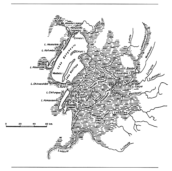
Fig. 2. LAKES AND SWAMPS OF THE BANGWEULU SYSTEM
(Welcomme, 1972)
LAKE BEU
| Geographical data | |
| Location: | Zambia - 11° 49'S; 33° 11'E |
LAKE CHISI
| Geographical data | |
| Location: | Zambia - 8° 54'S; 29° 47'E |
| Surface area: | variable: 34–60 km2 of open water (total area: 100–170 km2) |
| Depth: | 7 m (max); 2.5 m (mean) |
| Special features: | part of Lake Mweru Wa Ntipa complex. During years of low water level Lake Chisi becomes separated from Lake Mweru Wa Ntipa. |
| Physical and chemical data: l | |
| Conductivity: | 115 μ S/cm |
| Total dissolved solids: | 82 mg/l |
| Fisheries data | |
| Total annual catch and effort: | |
| Year | Total catch (t) | No. of Fishermen |
| 1953 | - | 21 |
| 1954 | 288 | 61 |
| 1955 | 339 | 60 |
| 1956 | 197 | 60 |
| 1957 | 125 | 30 |
| 1958 | 281 | 40 |
| 1959 | 307 | 40 |
| 1960 | 235 | 40 |
| 1961 | 190 | 30 |
| 1962 | 150 | 36 |
| 1963 | 154 | 28 |
| 1964 | 432 | 26 |
| 1965 | 482 | 41 |
| 1966 | 360 | 28 |
| 1967 | 402 | 38 |
| 1968 | 197 | 28 |
| 1969 | 185 | 25 |
| 1970 | 118 | 20 |
| 1971 | 72 | 13 |
| 1972 | 47 | 8 |
LAKE ISHIBA NGANDU
| Geographical data | |
| Location: | Zambia - 11° 14'S; 31° 15'E |
| Surface area: | 3.2 km2 |
| Max. length: | 4.5 km |
| Max. width | 1.0 km |
| Outflowing river: | Mansha |
LAKE LUSIWASHI
| Geographical data | |
| Location: | Zambia - 12° 58'S; 30° 46'E |
| Surface area: | 80 km2 |
| Max. length: | 19 km |
| Max. width: | 9 km |
| Outflowing river: | Lukusashi |
Fisheries data
Total annual catch and effort:
| Year | Total catch (t) | No. of fishermen | No. of boats |
| 1970 | 18 | - | - |
| 1971 | 40 | - | - |
| 1972 | 82 | - | - |
| 1973–77 | - | - | - |
| 1978 | 277 | - | - |
| 1979 | 255 | - | - |
| 1980 | 339 | - | - |
| 1981 | 300 | 163 | 118 |
| 1982 | 423 | - | - |
Potential annual yield: 500 t (Coopconsult-Propesca, 1982)
LAKE MWANGE
| Geographical data | |
| Location: | Zambia - 13° 34'S; 22° 26'E |
| Surface area: | 2.8 km2 |
| Max. length: | 4 km |
| Max. width | 1 km |
| Major inflowing river: | Litapi (Zambezi tributary) |
| Outflowing river: | Litapi |
LAKE MWERU
(International water)
| Geographical data (see Fig. 3) | ||
| Location: | Zaire, Zambia - 8° 28'–9° 31'S; 28° 20'–29° 10'E | |
| Altitude: | 930 m | |
| Surface area: | Zaire | 1 950 km2 (42%) |
| Zambia | 2 700 km2 (58%) | |
| Total | 4 650 km2 (Konare, 1984) | |
| Depth: | 37 m (max); 10 m (mean: N. basin); 3 m (mean: S. basin) | |
| Volume: | 38 km3 (15 km3 in Zaire, 23 km3 in Zambia) | |
| Max. length: | 124 km | |
| Max. width: | 51 km | |
| Shoreline: | 350 km (140 km in Zaire, 210 km in Zambia) | |
| Annual fluctuation in level: 5 m (max); 1.5 m (mean) | ||
| Major inflowing rivers: Luapula, Kalungwishi | ||
| Outflowing river: | Luvua into Lualaba | |
| Special features: | the inflowing Luapula River is flanked from both sides of its course between the Johnson Falls at its point of discharge into Lake Mweru by an extensive floodplain (the Luapula Floodplain), covering 1 500 to 2 400 km2 with scattered permanent lagoons. This area is known as the Kifakula Depression. | |
| Physical and chemical data: | ||||
| Surface temperature: | 19–30° C | |||
| Conductivity: | K20 70–125 μ S/cm (De Kimpe, 1960) | |||
| Dissolved solids: | 76 mg/l (Stappers, 1914) | |||
| pH: | 6.4–9.3 (De Kimpe, 1960) | |||
| 8.5 (Konare, 1984) | ||||
| Oxygen: | 5.4–8.9 mg/l; 70–120% saturation (Compere & Symoens, 1987) | |||
| Ionic composition: | (Stappers, 1914) (Talling & Talling, 1965) | |||
| mg/l | mg/l | |||
| Na | - | 4.06 | ||
| K | - | 1.25 | ||
| Ca | 13.07 | 7.05 | ||
| Mg | 6.0 | 5.01 | ||
| HCO3+CO3 | 48.08 | 48.08 | ||
| Cl | 19.08 | 5.0 | ||
| SO4 | - | 3.07 | ||
| SiO2 | 1.03 | 10.05 | ||
| Fisheries data | ||||
| No. of fish species: | over 100 species; 27 are of fishing interest: | |||
| mainly: | Oreochromis macrochir (80%); Clarias spp; Synodontis sp., Barbus altivelis, Mormyridae (Konare, 1984) | |||
| No. of fishermen: | in Zambia, in 1980–82: (Coopconsult-Propesca, 1982) | |||
| 3 570 - Lake Mweru | ||||
| 3 640 - Luapula River and floodplain | ||||
| No. of boats: | in Zambia, in 1980–82: (Coopconsult-Propesca, 1982) | |||
| Lake Mweru | Luapula River/floodplain | |||
| dugout canoes | 734 | 1 790 | ||
| plank boats | 1 103 | 207 | ||
| fiberglass | 145 | 25 | ||
| with engine | 250–300 | 100 | ||
| Total annual catch and effort: in Zambia | ||||
| Year | Total catch (t) | No. of boats |
| Lake Mweru, including Luapula River and floodplain | ||
| 1966* | 9 479 | - |
| 1967* | 7 543 | - |
| 1968* | 7 617 | - |
| 1969* | 7 717 | - |
| 1970* | 7 326 | - |
| 1971* | 8 342 | - |
| 1972* | 9 068 | - |
| 1973* | 8 031 | - |
| 1974* | 8 135 | - |
| 1975 | 8 483 | - |
| 1976 | 10 680 | - |
| 1977 | 9 534 | - |
| 1978 | 7 629 | 2 896 |
| 1979 | 9 438 | - |
| 1980 | 7 663 | - |
| 1981 | - | - |
| 1982 | 7 907 | - |
| Luapula River and floodplain | ||
| 1973* | 3 600 | 1 219 |
| 1974* | 3 700 | - |
* Source: 1966–1974: Bazigos et al., 1975
| Potential annual yield: | |
| 17 000 t in Zambia (including Luapula River) (Coopconsult-Propesca, 1982) | |
| 12 000 t in Zaire | |
| 16 000 t in Zambia | |
| 28 000 t total (Konare, 1984) | |
| 35 000–52 000 t/yr for entire Luapula-Mweru system (cited by Compere & Symoens, 1987) | |
| Productivity: | 60 kg/ha (cited by FAO, 1983c) |
| 50 kg/ha (De Kimpe, 1960) | |
| Specific reference: | De Kimpe, 1960, 1964 |
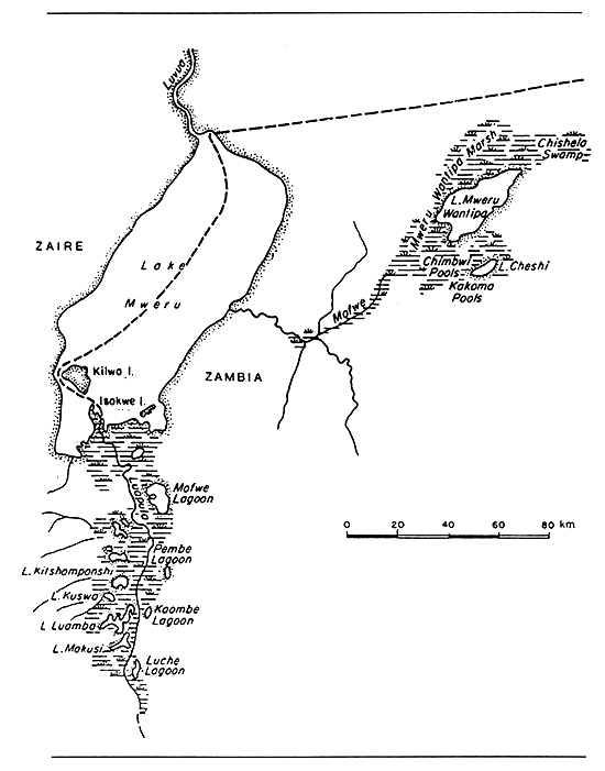
Fig. 3. LAKE MWERU,, THE KIFAKULA DEPRESSION,
LAKE MWERU WA NTIPA, AND LUAPULA SWAMPS
(Welcomme, 1972)
LAKE MWERU WA NTIPA
| Geographical data (Welcomme, 1972) | |
| Location: | Zambia - 8° 44'S; 29° 45'E (see Fig. 3) |
| Altitude: | 928 m |
| Surface area: | Open water: 1 600 km2; surrounding swamp: 1 200 km2; Lake Chesi: 60 km2 |
| Depth: | 9 m (max); 3 m (mean) |
| Max. length: | 105 km |
| Max. width: | 25 km |
| Catchment area: | 11 900 km2 |
| Annual fluctuation in level: | |
| the lake follows a cycle of about 15 years' duration, with a possibility of dessication periodically. In 1964 the cycle reached a maximum, with depth of 9.14 m. | |
| Major inflowing river: | direct drainage, Kalungwishi |
| Outflowing river: | communicates with Lake Mweru via the swampy Mofure depression when full. |
| Physical and chemical data: (Welcomme, 1972) | |
| Surface temperature: | 19–28° C |
| Conductivity: | K20 600 μ S/cm |
| Dissolved solids: | 429 mg/l |
| pH: | 8.2 |
| Fisheries data | |
| Main catches: | Oreochromis macrochir |
| No. of fishermen: | 3 500 in 1980–82 (Coopconsult-Propesca, 1982) |
| No. of boats: | in 1980–82: (Coopconsult-Propesca, 1982) |
| 110 dug-out canoes | |
| 1 530 plank boats | |
| 160 fiberglass boats | |
| 320 with engine | |
Comments: Ex-swamp that was virtually dry in the late 1950's. Conflicting land use with national park. Market-oriented gill-net fishery is landing 90% good-sized tilapia (Oreochromis macrochir). (Coopconsult-Propesca, 1982)
Total annual catch and effort:
| Year | Total catch (t) | No.of fishermen | No.of boats |
| 1966* | 1 672 | - | - |
| 1967* | 2 865 | - | - |
| 1968* | 3 704 | - | - |
| 1969* | 4 125 | - | - |
| 1970* | 4 216 | - | - |
| 1971* | 3 825 | - | - |
| 1972* | 5 812 | - | - |
| 1973* | 8 113 | - | 1 200 |
| 1974* | 5 992 | - | - |
| 1975 | 16 765 | - | - |
| 1976 | 13 330 | - | - |
| 1977 | 12 521 | 2 124 | 1 407 |
| 1978 | 10 352 | - | - |
| 1979 | 7 878 | - | - |
| 1980 | 9 094 | - | - |
| 1981 | - | - | - |
| 1982 | 10 979 | - | - |
* Source: 1966–1974: Bazigos et al., 1975
Potential annual yield: 13 000 t (Coopconsult-Propesca, 1982)
LAKE TANGANYIKA
(International water)
| Geographical data (see Fig. 4) | |||
| Location: | Burundi, Tanzania, Zaire, Zambia - 3° 20'–8° 50'S; 30°E; | ||
| Altitude: | 773 m | ||
| Surface area: | Burundi | 2 600 km2 | ( 8%) |
| Tanzania | 13 500 km2 | (41%) | |
| Zaire | 14 800 km2 | (45%) | |
| Zambia | 2 000 km2 | ( 6%) | |
| Total | 32 900 km2 | ||
| Depth: | 1 435 m (max); 700 m (mean) | ||
| Volume: | 18 940 km3 (1 140 km3 in Zambia) | ||
| Max. length: | 673 km | ||
| Max. width: | 48 km | ||
| Shoreline: | 1 500 km total; (150 km in Zambia) | ||
| Catchment area: | 249 000 km2 | ||
| Major inflowing river: | Malagarasi, Ruzizi | ||
| Outflowing river: | Lukuga | ||
| Physical and chemical data (Talling & Talling, 1965) | ||
| Conductivity: | K20 520–610 μ S/cm | |
| pH: | 7.3–7.8 | |
| Oxygen limit: | 80 m, North Basin; 150 m, South Basin (Aubray, 1976) | |
| Photosynthetic production: 0.8–1.1 gC/m2 day (Melack, 1976) | ||
| Ionic composition: | mg/l | |
| Na | 57.0 | |
| K | 35.0 | |
| Ca | 9.3 | |
| Mg | 43.3 | |
| Cl | 26.5 | |
| SO4 | 5.0 | |
| SiO2 | 0.38 | |
| HCO3+CO3 | 409.3 | |
| Fisheries data | ||
| No. of fish species: | 214 (134 belong to the Cichlidae family) (Greenwood, 1964) | |
| Main catches: | (Aubray, 1976) | |
| Clupeidae: | ||
| Stolothrissa tanganicae: | 75% | |
| Limnothrissa miodon: | 10% | |
| Centropomidae: | 15% | |
| Lates spp. (3 species), Luciolates stappersi | ||
| No. of fishermen in Zambia: | ||
| in 1976: 1 356 | ||
| in 1980–82: 1 800 + 4 600 helpers (Coopconsult-Propesca, 1982) | ||
| in 1988: 2 000 (Mikkola & Lindquist, 1989) | ||
| No. of boats in Zambia: | ||
| in 1974: 635 (Bazigos et al., 1975) | ||
| in 1976: 1 096 (Bazigos et al., 1975) | ||
| in 1980–82: (Coopconsult-Propesca, 1982) | ||
| 1 240 total | ||
| 220 dugout canoes | ||
| 980 plankboats | ||
| 40 fiberglass | ||
| (130 with engine) | ||
| in 1988: (Mikkola & Lindquist, 1989) | ||
| 270 total | ||
| 19 industrial fishing units (purse seiners) | ||
| 1 artisanal fishing unit (lift nets, etc.) | ||
| 250 coastal canoe fishing units | ||
| Total annual catch and effort: | ||
in Zambia:
| Year | Total catch (t) | No.of fishermen | No.of boats |
| 1966* | 6 500 | - | - |
| 1967* | 11 968 | - | - |
| 1968* | 10 104 | - | - |
| 1969* | 7 066 | - | - |
| 1970* | 10 835 | - | - |
| 1971* | 6 988 | - | - |
| 1972* | 6 281 | - | - |
| 1973* | 5 488 | - | - |
| 1974* | 4 522 | - | 635 |
| 1975 | 7 440 | - | - |
| 1976 | 6 501 | 1 356 | 1 096 |
| 1977 | 7 866 | - | - |
| 1978 | 6 474 | - | - |
| 1979 | - | - | - |
| 1980 | 8 256 | - | - |
| 1981 | - | - | - |
| 1982 | 8 010 | - | - |
| 1988** | 14 000 | 2 000 | - |
* 1966–1974: Bazigos et al., 1975
** 1988: Mikkola & Lindquist, 1989
| in Lake: | 1982 | 1988 |
| (Corsi et al., 1986) | (Mikkola & Lindquist, 1989) | |
| Burundi | 13 600 | 16 000 |
| Tanzania | 25 000 | 25 000 |
| Zaire | 30 000 | 30 000 |
| Zambia | 10 500 | 14 000 |
| Total | 80 000 | 85 000 |
| Potential annual yield: | ||||
| in Zambia: | 18 000 t (Mikkola & Lindquist, 1989) | |||
| 19 000 t (Welcomme, 1972; Coopconsult-Propesca, 1982; Corsi et al., 1986) | ||||
| in Lake: | ||||
| (Corsi et al., 1986) | (Mikkola & Lindquist, 1989) | |||
| (t) | (max. t) | |||
| Burundi | 21 000 | 23 000 | ||
| Tanzania | 122 000 | 121 000 | ||
| Zaire | 135 000 | 133 000 | ||
| Zambia | 19 000 | 18 000 | ||
| Total | 300 000 (90 kg/ha) | 295 000 | ||
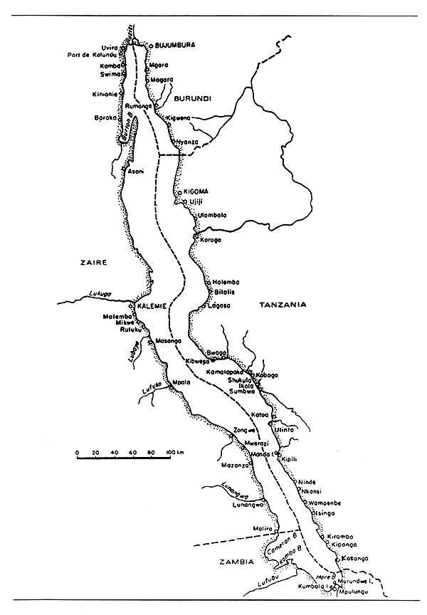
Fig. 4. LAKE TANGANYIKA
(Welcomme, 1972)
KAFUE RIVER
| Geographical data (see Figs. 1 and 5) | |
| Source: | near Ndola |
| Altitude: | 1 513 m asl |
| Total length: | 945 km |
| Drainage area: | 154 200 km2 |
| Countries traversed: | Zambia |
| Major tributaries: | Lufupa, Mushingoshi |
| Discharge to: | Luswishi |
| Volume of discharge at mouth: 10.3 km3 per year (range: 2–30 km3) | |
| Flood regime: | high water from January to May |
| Special features: | Lukanga Swamp, Itezhitezhi Reservoir, Kafue Flats/Gorge Reservoir |
| Physical and chemical data: see entry “Kafue Flats” under Reservoirs | |
| Fisheries data: see entry “Kafue Flats” under Reservoirs | |
LUANGWA RIVER
(International water)
| Geographical data | |
| Source: | near Zambia/Malawi frontier |
| Altitude: | 1 658 m asl |
| Total length: | 790 km (710 km in Zambia; 80 km along Zambian/Mozambique frontier) |
| Drainage area: | 147 500 km2 |
| Countries traversed: | Zambia, Mozambique |
| Major tributaries: | Lukusashi, Lusemfwa |
| Discharge to: | Cahora Bassa Reservoir confluently with the Zambezi River |
| Volume of discharge at mouth: 8 km3 per year | |
| Flood regime: | main discharge from April to July |
| Special features: | two reservoirs (Mulungushi and Mita Hills) within the Lusemfwa tributary basin) |
| Fisheries data: | |
| Total annual catch: | 786 t in 1980 (Fisheries Dept. estimate, Govt. of Zambia; cited in Coopconsult-Propesca, 1982) |
LUAPULA RIVER
(International water)
| Geographical data (see Figs. 3) | |
| Source: | Lake Bangweulu, Zambia |
| Altitude: | 1 140 m asl |
| Total length: | 560 km |
| Countries traversed: | Zambia, Zaire |
| Discharge to: | Lake Mweru |
| Special features: | the Luapula flows through an extensive swamp system which occupies the Kifukula depression. This stretches from Johnson Falls to Lake Mweru, a distance of some 160 km and a width of 5–18 km. The total area of the swamp is 1 500 km2 during the wet season, when a depth of between 5 and 10 m is attained. The extent of the flooding varies from year to year. Larger permanent lakes on the floodplain include Kifikula and Kitshomponshi in Zaire and Mofwe, Pembe and Kaombe in Zambia. |
| Physical and chemical data: | |
| Conductivity: | 150–180 μ S/cm |
| 24.5 μ S/cm (Toews, pers.comm.) | |
| pH: | 6.2 (Toews, pers.comm.) |
| Fisheries data: see entry: “Lake Mweru” | |
ZAMBEZI RIVER
(International water)
| Geographical data (see Figs. 1 and 5) | |
| Source: | northwest Zambia and eastern Angola |
| Altitude: | 1 600 m |
| Total length: | 2 574 km |
| Drainage area: | 1 300 000 km2 |
| Countries traversed: | Angola, Mozambique, Zambia, Botswana, Namibia, Zimbabwe |
| Major tributaries: | Cuando, Kafue, Luangwa, Shire. The Zambezi system also communicates with the Okovango system via the Chobe River. |
| Discharge to: | Indian Ocean - 18° 47'S; 36° E |
| Volume of discharge at mouth: 7 070 km3/sec | |
| Flood regime: | December to July, maximum in March |
| Special features: | Barotse floodplain 700–9 000 km2, Kafue flats (200–7 000 km2), Lukanga swamps (3 000–8 000 km2), Kariba and Cahora Bassa dams/reservoirs. |
Physical and chemical data above Lake Kariba (Coche, 1968)
| Flood | Low water | |||
| Temperature: °C | 30 | 17 | ||
| pH: | - | 7.4 | ||
| Conductivity: K20 | 50 μ S/cm | 96 μ S/cm | ||
| Total alkalinity: | 20 mg/l | 44 mg/l | ||
| Total hardness: | 17.9 mg/l | 38.1 mg/l | ||
| Ionic composition: | mg/l | mg/l | ||
| Na | 1.70 | 3.26 | ||
| K | - | 0 88 | ||
| Ca | 4.93 | - | ||
| Mg | 1.47 | 3.86 | ||
| NO2-N | 0.00376 | 0.00024 | ||
| NO3-N | 0.0047 | 0.0158 | ||
| PO4-P | 0.0295 | 0.0078 | ||
| Fisheries data | ||||
| No. of fish species: Upper Zambezi: 49; Middle Zambezi: 50 (Jubb, 1961) | ||||
| Total annual catch in Zambia: | ||||
| Middle Zambezi (between Kariba dam and Cahora Bassa Reservoir):
750 t in 1981 Upper Zambezi: see entry “Barotse Floodplain”, below. | ||||
BAROTSE FLOODPLAIN/UPPER ZAMBEZI RIVER
| Geographical data | |
| Location: | Zambia - 15°30'S; 23° E (see Zambezi River) Formed by lateral flooding of Upper Zambezi River |
| Surface area: | 700 km2 - dry season; |
| 7 800 km2 - wet season, central plain; | |
| 3 100 km2 - wet season, southern plain | |
| Depth: | 5 m during floods |
| Max. length: | central plain: 241 km; southern plain: 97 km |
| Max. width: | central plain: 32 km; southern plain: 32 km |
| Flood regime: | February-June, peak in April |
| Special features: | contains numerous small lakes (i.e. Silita, Njolo, Siwa, Chilele, Sihole). |
| Physical and chemical data: | |
| Conductivity: | K20 57–102 μ S/cm (FAO/UN, 1969) |
| Fisheries data: | |
| Main catches: | Cichlids, Hydrocynus sp. |
| No. of fishermen: | 3 400 in 1980/82 (Coopconsult-Propesca, 1982) |
| No. of boats: | 2 179 dug-out canoes in 1980/82 (Coopconsult-Propesca, 1982) |
| Total annual catch and effort: | |
| Year | Total catch (t) | No.of fishermen | No.of boats |
| 1966* | 1 000 | - | - |
| 1967* | 1 000 | - | - |
| 1968* | 1 000 | - | - |
| 1969* | 1 000 | - | - |
| 1970* | 3 500 | - | - |
| 1971* | 3 500 | - | - |
| 1972* | 3 500 | - | - |
| 1973* | 3 500 | - | 1 734 |
| 1974* | 3 500 | - | - |
| 1975 | 5 827 | - | - |
| 1976 | 5 995 | 1 358 | 2 734 |
| 1977 | 3 490 | - | - |
| 1978 | 4 475 | - | - |
| 1979 | 5 559 | - | - |
| 1980 | 6 572 | - | - |
| 1981 | 6 691 | - | - |
| 1982 | 5 200 | - | - |
* Source: Bazigos et al., 1975
Potential annual yield: 14 000 t (Coopconsult-Propesca, 1982)
Specific reference: FAO/UN (1969, 1970)
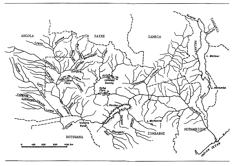
Fig. 5. RIVERS AND LAKES OF THE ZAMBEZI
(Welcomme, 1972)
LUKANGA SWAMP
| Geographical data | |
| Location: | Zambia - 14° 25'S; 27° 45'E |
| Surface area: | 8 000 km2 at high water; 3 000 km2 at low water |
| Max. length: | 80 km |
| Max. width: | 65 km |
| Major inflowing rivers: | Kafue (lateral flooding); Lukanga |
| Fisheries data | |
| Main catches: | Cichlids, Alestes sp. (Coopconsult-Propesca, 1982) |
| No. of fishermen: | 1 300 in 1980–82 (Coopconsult-Propesca, 1982) |
| No. of boats: | 1 000 in 1980–82 (Coopconsult-Propesca, 1982) (980 dug-out canoes; 20 plank boats) |
| Total annual catch and effort: | |
| Year | Total catch (t) | No.of fishermen | No.of boats |
| 1965 | - | - | 507 |
| 1966* | 658 | - | - |
| 1967* | 955 | - | - |
| 1968* | 1 602 | - | - |
| 1969* | 1 366 | - | - |
| 1970* | 1 724 | - | - |
| 1971* | 1 900 | - | - |
| 1972* | 2 370 | - | - |
| 1973* | 1 801 | - | 543 |
| 1974* | 1 707 | - | - |
| 1975 | 1 802 | - | - |
| 1976 | 856 | 689 | 516 |
| 1977 | 1 005 | - | - |
| 1978 | 786 | - | - |
| 1979 | 765 | - | - |
| 1980 | 549** | - | - |
| 1981 | - | - | - |
| 1982 | 2 601 | - | - |
* Source: Bazigos et al., 1975
** Total catch in 1980: 3 500 t (Coopconsult-Propesca, 1982)
Potential annual yield: 8 000 t (Coopconsult-Propesca, 1982)
ITEZHITEZHI RESERVOIR
| Geographical data | |
| Location: | Zambia |
| Altitude: | 1 029.5 m asl |
| Surface area: | 360 km2 |
| Major inflowing river: | Kafue |
| Outflowing river: | Kafue |
| Fisheries data | |
| No. of fishermen: | 290 (1981) |
| No. of boats: | 253 (1981) |
| Total annual catch: | 400 t (1981) |
| Potential annual yield: 1 800 t (Coopconsult-Propesca, 1982) | |
KARIBA RESERVOIR
(International water)
| Geographical data (see Fig. 6) | ||
| Location: | Zimbabwe, Zambia 16° 28'-18° 04'S; 26° 42'–29° 03'E | |
| Date closed: | 1958 | |
| Altitude: | 485 m | |
| Surface area: | Zimbabwe | 2 952 km2 (55%) |
| Zambia | 2 412 km2 (45%) | |
| Total | 5 364 km2 | |
| Depth: | 120 m (max); 29.2 m (mean) | |
| Volume: | 156 km3 | |
| Max. length: | 277 km | |
| Max. width: | 40 km | |
| Shoreline: | 2 164 km | |
| Catchment area: | 823 200 km2 | |
| Annual fluctuation in level: 3–4 m | ||
| Major inflowing rivers: Zambesi, Umiali | ||
| Outflowing river: | Zambesi | |
| Physical and chemical data | ||
| Surface temperature: | 17–32°C. | |
| Lake overturns once a year between March and July. Monothermy about 22°C. | ||
| Dissolved solids: | 40–70 mg/l | |
| (Harding, 1961) | (Coche, 1968 and 1969) | |||
| Basins I & II | Basins III & IV | |||
| Conductivity: | μ S/cm | - | K25 50–100 | K20 88–115 |
| pH: | - | 7.5–8.0 | 7.8–8.9 | |
| Ionic composition: | mg/l | mg/l | mg/l | |
| Na | 5–8 | 1.8–3.6 | 3.2–4.7 | |
| K | - | trace-1.8 | 0.6–1.6 | |
| Ca | 12.4–14 | 2–10 | 7–13 | |
| Mg | 2.0–3.6 | 0.5–3 | 0.5–3 | |
| HCO3+CO3 | 62.2–72.0 | - | - | |
| Cl | 1–3 | - | - | |
| SO4 | 2.5–3 | - | - | |
| NO2-N | - | 0–0.002 | 0–0.004 | |
| NO3-N | - | 0.003–0.04 | 0.010–0.050 | |
| PO4-P | - | 0–0.05 | 0.01–0.05 | |
| Fisheries data | |
| No. of fish species: 46 (Jackson, 1971) | |
| Limnothrissa miodon, was introduced in 1967–68. | |
| Main catches: | Limnothrissa miodon, Hydrocynus vittatus, mormyrids, tilapias (Marshall, 1984a; Balarin, 1984) |
| No. of fishermen: | 1 000 in Zambia in 1980–82 (Coopconsult-Propesca, 1982) |
| No. of boats: | 512 in Zambia in 1980–82 (Coopconsult-Propesca, 1982): |
| 420 dug-out canoes | |
| 56 plank boats | |
| 36 fiberglass boats | |
| +37 steel crafts (not in operating condition) | |
Total annual catch: in Zambia
| Year | Total catch (t) | No.of fishermen | No.of boats |
| 1966* | 1 436 | - | - |
| 1967* | 980 | - | - |
| 1968* | 1 410 | - | - |
| 1969* | 1 345 | - | - |
| 1970* | 2 581 | - | - |
| 1971* | 2 311 | - | 294 |
| 1972* | 1 955 | - | - |
| 1973* | 3 058 | - | - |
| 1974* | 2 181 | - | - |
| 1975–79 | - | - | - |
| 1980** | 1 000 | 1 000 | 512 |
| 1982 | 3 500 | - | - |
Sources: * 1966–74: Bazigos et al., 1975
** 1980: Coopconsult-Propesca, 1982
| Potential annual yield: | |
| 8 000 t in Zambia (Coopconsult-Propesca, 1982) | |
| Productivity: | 23.2 kg/ha/yr based on MEI relationship (Marshall, 1984c) |
| Specific references: | |
| Entz, 1984 | |
| Kapetsky & Petr, 1984 | |
| Marshall, 1984a,b,c | |
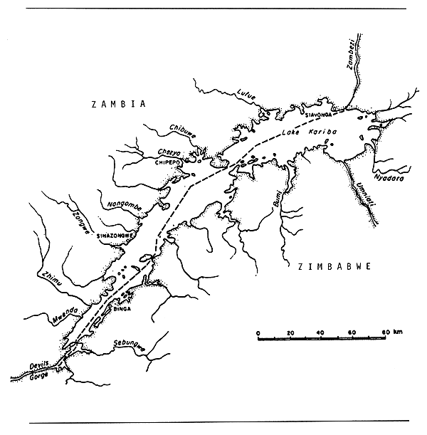
Fig. 6. LAKE KARIBA
(Welcomme, 1972)
MITA HILLS RESERVOIR
| Geographical data | |
| Location: | Zambia - 14° 10'S; 29° 06'E |
| Surface area: | 50 km2 |
| Max. length: | 29 km |
| Max. width: | 2.5 km |
| Major inflowing river: | Lunsemfwa |
| Outflowing river: | Lunsemfwa |
MULUNGUSHI RESERVOIR
| Geographical data | |
| Location: | Zambia - 14° 40'S; 28° 49'E |
| Surface area: | 24 km2 |
| Max. length: | 17 km |
| Max. width: | 2 km |
| Major inflowing river: | Mulungushi |
| Outflowing river: | Mulungushi |
KAFUE FLATS/GORGE RESERVOIR COMPLEX
| Geographical data (see Figs. 1 and 5) | |||
| Location: | Zambia on Kafue River | ||
| Altitude: | 1 021 m asl at upstream end; | ||
| 976.6 m USL at Kafue Gorge dam | |||
| Dam height: | 45 m | ||
| Date closed: | 1972 | ||
| Surface area: | 4 340 km2 during wet season; | ||
| 600–1 600 km2 during dry season | |||
| Depth: | 2 m (wet season) | ||
| Volume: | 0.8 km3 for Kafue Gorge Reservoir | ||
| Max. length: | 425 km | ||
| Max. width: | 9.7 km | ||
| Catchment area: | 45 325 km2 | ||
| Annual fluctuation in level: 3.3 m (mean) | |||
| Major inflowing river: Kafue (outflow from Itezhitezhi dam) | |||
| Outflowing river: | Kafue | ||
| Special features: | regulation of the Kafue River above (Itezhitezhi dam, closed in 1977) and below (Kafue Gorge dam, closed in 1972) the flats alters the natural flooding regime by decreasing and regularizing the maximum area flooded, decreasing the flood duration, delaying the flood, increasing the area permanently flooded during the dry season and reducing the amplitude of water level fluctuation by raising the minimum level. | ||
| Physical and chemical data | |||
| Surface temperature: | 17–33°C (24°C mean) | ||
| Conductivity: | K25 140–382 μ S/cm | ||
| Dissolved solids: | 68–220 mg/l | ||
| pH: | 6.7–8.2 | ||
| Ionic composition: | mg/l | ||
| Na | 3.5–8.5 | ||
| K | 1.17–3.13 | ||
| Ca | 15.8–45.3 | ||
| Mg | 4.1–18.0 | ||
| HCO3+CO3 | 73.2–268.4 | ||
| Cl | 0–3.55 | ||
| Fisheries data | |||
| Main catches: | Oreochromis macrochir and other cichlids | ||
| No. of fishermen: 4 000 in 1980–82 (Coopconsult-Propesca, 1982) | |||
| No. of boats: | 2 200 in 1980–82 (Coopconsult-Propesca, 1982) (1 750 dug-out canoes; 450 fiberglass boats) | ||
| Total annual catch and effort: | |||
| Year | Total catch (t) | No.of fishermen | No.of boats |
| 1966* | 10 709 | - | - |
| 1967* | 3 941 | - | - |
| 1968* | 6 183 | - | - |
| 1969* | 9 938 | - | - |
| 1970* | 9 582 | 1 262 | 1 163 |
| 1971* | 8 247 | - | - |
| 1972* | 7 874 | - | - |
| 1973* | 6 289 | 1 034 | 1 021 |
| 1974* | 5 177 | - | - |
| 1975 | 7 226 | - | - |
| 1976 | 9 306 | - | - |
| 1977 | 9 829 | - | - |
| 1978 | 8 634 | 2 632 | 1 790 |
| 1979 | 10 851 | - | - |
| 1980 | 7 741 | - | - |
| 1981 | 9 619 | - | - |
| 1982 | 8 907 | - | - |
* Source: 1966–74: Bazigos et al., 1975
Potential annual yield: 17 000 t (Coopconsult-Propesca, 1982)
7. BIBLIOGRAPHY
Aubray, 1976
Balarin, 1984
Bazigos et al., 1975
Coche, 1968; 1969
Compere & Symoens, 1987
Coopconsult-Propesca S.p.A., 1982
Corsi et al., 1986
De Kimpe, 1960; 1964
Entz, 1984
FAO/UN, 1969; 1970
Greenwood, 1964
Harding, 1961
Jackson, 1971
Jubb, 1961
Kaptesky & Petr, 1984
Konare, 1984
L'Heureux, 1985
Marshall, 1984a,b,c
Melack, 1976
Mikkola & Lindquist, 1989
Mortimer, 1965
Muncy, 1973
Stappers, 1914
Talling & Talling, 1965
Toews, 1975
Welcomme, 1972; 1979a
![]()
![]()
![]()