Variability of erosion factors
Before opting for a specific erosion control method, it is best to take another look at the causes of erosion and the factors that modify the form it takes under the environmental conditions where this work was done - i.e. the old and weathered hills of Africa.
By analysing the available findings of the erosion forecast equation - i.e. 560 plots per year - these various factors can be reviewed and quantified (Roose 1975):
• The climatic aggressiveness factor (RUSA) is very high, rising from 200 units in northern Burkina Faso to over 1400 in southern Côte d'Ivoire (Figure 17). Moreover, it is very unevenly divided over the year: 75% of annual R is often concentrated in 2 or 3 months at the start of the cropping season when the soil has little covering.
R, the erosive force of rainfall,
varies from 100 to 2000 |
• Soil resistance to erosion of ferralitic soils (K = 0.01 to 0.18) and cropped tropical ferruginous soils (K = 0.2 to 0.3) is much better than that of many leached soils in temperate regions (where K varies from 0.2 to 0.7).
K, soil erodibility, varies from
0.01 to 0.3 |
However, it is difficult to reduce erodibility once a soil has become degraded and lost its organic matter, clay, structure and permeability: K rises from 0.1 to 0.2 or 0.35 with the degradation of cropped soils.
• The topographical factor combines the length (L) and slope (S) factors. The length factor is neither constant nor very great: for practical reasons, a team of American scientists has estimated that erosion increases in proportion to the square root of slope length (SL²). Slope (gradient), on the other hand, does have a decisive effect. Sediment load increases exponentially (exponent = ± 1.4 to 2) with the percentage of slope (Zingg 1940, Hudson 1973, Roose 1975) - or in accordance with a very close second-degree equation (Wischmeier and Smith 1960). On the commonest slopes (0.1 to 15 %) with a length of 60 metres, SL varies from 0.1 to 5.
SL, the topographical index,
varies from 0.1 to 5 (and up to 20 in mountainous areas) |
• Soil cover (the C factor) from plant cover (and stones) has a much greater effect than all the other erosion factors. Thus, however aggressive the climate, whatever the slope, whatever the soil type, erosion will be slight with a soil cover of over 90%. However, it should be noted that cropping techniques play a major role during the crop growth cycle.
C, the interaction between plant
cover and cropping techniques, ranges from 1 to 0.001 |
In conclusion, in the tropical regions of interest here, the most important factors for interventions to curtail erosion and runoff are plant cover and slope. There seem to be four feasible biological approaches.
Unlike
mechanical interventions, which are not cheap, not
cost-effective, and not easy to maintain, the biological
methods suggested here are well-suited to tropical
conditions where grass is abundant, slopes are medium,
and technical and financial resources are scarce.
Similarly, with a view to stabilizing water supplies and
waterways and protecting roads and irrigation works, as
well as increasing farm production, there is no doubt
that it is more helpful to increase absorption over the
whole farmed area by extending plant cover than by
evacuating all excess runoff. |
Conclusions on the applicability of the USLE in Africa
Now that erosion has been measured on quite a few -- more than 560 -- experimental plots in West, North and Central Africa, there is a basis for questioning the applicability of the "universal" soil losses equation (Wischmeier and Smith 1978) in Africa.
1. The equation applies only to sheet and rill erosion (hence to the nascent erosion that concerns us here) in hilly country, excluding mountainous areas where landslides and linear erosion (rills, gullies and torrents) are predominant. It addresses neither the type of runoff nor suspended load. If necessary, each subequation can be adjusted to take account of runoff energy on steep slopes.
2. This empirical model requires a large number of results replicated at different times and places, for it looks at behaviour in the medium and long term (20 years). The use of rainfall simulators (with one-time data for each situation) can offset the lack of data on plots under natural rainfall, but cannot replace them. It is always difficult to compare specific results obtained under simulated rainfall with average results over a number of years on actual plots. Experiments on agricultural stations are long and costly. In practice, in the absence of sufficient local results, use can be made of the tables presented in this work, which give the corresponding coefficients for Africa or the United States (cf. Wischmeier and Smith 1978).
3. The equation is based on results on small plots (100 m²), fields or very small catchments (a few hectares). This leads to problems of scale when trying to forecast regional figures for erosion, and especially for predicting sediment load in large watersheds where water management systems may be threatened by siltation.
4. It is difficult to set precise figures for tolerable erosion levels, since the equation ignores the quality of eroded material. The wealth of many tropical soils is stored in the top 20 centimetres (especially under forest), and sheet erosion selectively carries away organic and mineral colloids, plus nutrients, which together assure the soil's water and chemical reserves (Roose 1967; 1973).
5. The equation seems to apply fairly well to soils rich in kaolinite, tempered, leached, brown soils, and tropical ferralitic and ferruginous soils, excluding soils rich in swelling clay (vertisols, tropical brown soils, saline soils), which very quickly present large-scale gullying due to their poor absorption capacity once they are wet.
6. Lastly, the equation ignores interactions between the different factors - interactions that proved very numerous as the results were analysed. For example, soil reaction to rainfall aggressiveness differs greatly depending on slope, whether the soil is clayey (rill erosion) or sandy (sheet erosion), and the condition of the soil surface (roughness due to cropping methods, prior soil moisture, management of crop residues).
Granted all this, it must be recognized not only the practicality of this equation in the field for rational land use planning, but also its scientific value in defining the relative influence of each of the factors involved. It is therefore very effective in fulfilling its purpose of defining the erosion control techniques to select in a given situation. On the old continent of Africa, use of Wischmeier's equation seems justified by a large number of results (560) concerning the soils, crops and slopes most widely farmed.
The aggressiveness factor takes full account of how cumulative rainfall and rainfall intensity and duration interact with soil losses. It might also be combined with a soil moisture factor that would show how wet the soil was before the rain. The laborious processing of thousands of pluviogrammes gave a first rough idea of the geographical distribution of mean annual rainfall aggressiveness in the southern part of West Africa, apart from the coastal strip and mountainous areas, indicating that rainfall is fairly homogenous in terms of how much, how hard, how long and how often. However, there is still the question of whether erosion control should be based on average figures for rainfall aggressiveness or on the dangers represented by exceptional storms that occur at ten- or even hundred-year intervals. Tests on the latter approach have not yet been carried out.
Soil cover in the form of plant cover and stones is much more important than all the other factors affecting erosion. Plant architecture and cropping techniques become secondary once the soil has a 90% cover. However, cropping techniques can have an effect during the growing phase, and the C factor allows selection of the techniques and plants best suited to local environmental conditions.
Soil erodibility. Contrary to an opinion widely held by agronomists, tropical ferralitic soils, and to a lesser extent tropical ferruginous soils, especially those with a high gravel content, seem less vulnerable than many leached soils in temperate regions. The striking damage found in tropical areas is in fact a result of the particular aggressiveness of tropical rains. The nomograph put forward by Wischmeier, Johnson and Cross in 1971 to allow rapid calculation of the index of soil resistance to erosion seems applicable so long as it is combined with a qualifying coefficient that takes account of the gravel or rock debris present in the tilled horizon (Dumas 1965). Lastly, it would seem that soils rich in swelling clay, such as vertisols, tropical brown soils and volcanic soils, require individual examination, for they act in a very specific way and the equation therefore does not hold in their case. Analysis is still needed of the very specific manner in which runoff appears.
TABLE 38
Assessment of measures
to be taken to reduce erosion to tolerable levels (here E = 1
t/ha/yr): example of the Sudano-Sahelian, cotton-growing area of
Mali
R |
K |
Max E risk t/ha/yr |
Erosion control method |
SL |
C |
P |
E risk t/ha/yr |
400 |
extensive system (r) 0.3 |
120 |
(a) No control |
0.4 |
0.8 |
1 |
38.4 |
(b) Diversion ditch/50 m |
0.24 |
0.8 |
0.5 |
11.5 |
|||
(c) Stone line/25 m |
0.12 |
0.8 |
0.5 |
5.7 |
|||
intensive system (r) 0.2 |
80 |
(a) No control |
0.4 |
0.4 |
0.5 |
6.4 |
|
(b) Diversion ditch/50 m |
0.24 |
0.4 |
0.5 |
3.8 |
|||
(c) Stone line/25 m |
0.12 |
0.4 |
0.5 |
1.9 |
|||
(a) + tied ridges |
0.4 |
0.4 |
0.1 |
1.3 |
|||
(b) + tied ridges |
0.24 |
0.4 |
0.1 |
0.8 |
|||
(c) + tied ridges |
0.12 |
0.4 |
0.1 |
0.4 |
|||
(a) + mulch or live cover |
0.4 |
0.01 |
1 |
0.3 |
The topographical factor, particularly length of slope, certainly represents a weak point in the equation, for it should be adjusted according to type and texture of soil, and type of plant cover. However, until sufficient data are collected under natural or simulated rain, it can be used in most practical cases. The caveat is, however, important for the choice of erosion control techniques, which are too often based on reducing length of slope, an approach effective only for rill erosion and rarely for sheet erosion. Such reservations must be even stronger when the effect of topographical position exceeds that of slope, for example where headward erosion has its origin in the drainage network or the valley bottom.
Biological-type erosion control techniques - in other words, those encouraging soil cover - are therefore the most effective, the least costly, and the best suited to conditions on the plains and largely undulating uplands of the old continent of Africa.
In conclusion, Wischmeier and Smith's equation cannot be described as universal, for it applies neither to swelling clay soils, nor to volcanic soils, nor to mountainous regions with young landforms where linear gullying erosion is predominant, nor to Saharan and Mediterranean areas where exceptional rainfall has a decisive importance. Nonetheless, it seems well suited to forecasting erosion in most types of cultivated land in West Africa, particularly gentle to medium slopes on clayey-sandy, tropical, ferralitic and ferruginous soils.
Implementation of Wischmeier's erosion forecast model
The aim here is that of defining a production system (including productive crop rotation, feasible cropping techniques and effective erosion control structures) which will keep erosion risk below the tolerance threshold - generally recognized as between 1 and 12 t/ha/yr, depending on soil-type. The Sudano-Sahelian, cotton-growing area of Mali can be taken as an example (Table 38):
1. Rainfall = 800 m: mean R index = 800 × 0.5 = 400 t/ha/yr (Figure 17).
2. The K factor - indicating erodibility - for cultivated tropical ferruginous soils in the region ranges from 0.3 for degraded soils to 0.2 for an intensive system recycling a great deal of organic matter (Figures 20 and 21).
3. SL, the topographical factor. Supposing that cropping is on a broad pediment with a 2% slope 300 metres long:
- Figure 22 shows that SL = 0.4;
- if a diversion ditch is introduced every 50 metres, SL = 0.24;
- if a diversion ditch is introduced every 25 metres, SL = 0.18;
- if a low stone bund or a hedge is introduced every 25 metres, SL = 0.12,
for each bund creates a 25-cm-high bank which reduces the gradient of the slope.
4. The C factor, for a continuous rotation, ranges from 0.4 to 0.8 depending on whether cropping is intensive or extensive (Table 29):
- the addition of groundnut would change nothing (C = 0.4 to 0.8);
- the succession of 4 years of cropping + 4 years of fallow would cut C by half
(Ccscsffff = a crop rotation of cotton, sorghum, cotton, sorghum, fallow, fallow, fallow, fallow)In the long term, the risks have been halved thanks to the fallow, but four years of production have been sacrificed.
In order to maintain production, another plot would have had to be cleared - a solution no longer possible in some areas of Africa, where population pressure causes landholding problems.
- A purely biological solution is possible with the use of mulch or cover plants (C = 0.01, and E = 0.32 t/ha/yr without resorting to either erosion control structures or ridging.
5. Erosion control practices (P). Calculations show that introducing erosion control structures is not enough; cropping practices and/or rotations must be altered. In the best of cases, with an intensive system, stone bunds every 25 metres and contour tillage, the erosion risk is still double the tolerance level (E = 1 t/ha/yr).
If tied contour ridging is introduced, erosion ranges between 0.4 and 0.8 where runoff dissipation or diversion structures are adopted. Although this second solution is a mechanical one and hence more expensive, it is also easier to implement in a semi-arid region where the biomass is eaten by livestock and the rainy season is too short to grow pulses as a catch crop under cereals.
Forms of linear erosion
The cause and processes of linear erosion
Factors in runoff
Controlling runoff and linear erosion
Cost effective gully treatment
When rainfall intensity exceeds the absorption capacity of the soil surface, puddles form which are then joined up by rivulets of water, and when these rivulets reach a certain speed 25 cm per second according to Hjulström (1935) - they take on an energy of their own. The energy such erosion generates is confined to and concentrated in flow lines on the steepest slopes, and no longer spread over the whole surface. Linear erosion is therefore an indication that runoff has become organized, picking up speed and acquiring a kinetic energy capable of cutting into the soil and carrying away larger and larger particles - and not only clay and silt as in selective sheet erosion, but gravel or pebbles and larger blocks once gullying begins.
There are some very well-researched manuals on the treatment of linear erosion (Hudson 1973; Gray and Leiser 1982; Cemagref 1982-88; Geyik 1986; Heusch 1988), as well as vast numbers of specialized articles (Boiffin, Papy and Peyre 1986; Watson, Laflen and Franti 1986; Govers et al. 1987; Laflen 1987; Meunier 1989; Poesen 1989; Deymier 1992; Combes 1992). The present work is concerned chiefly with controlling soil degradation and the onset of erosion. It will therefore give a brief description of the various types of gullying and their causes, followed by an explanation of treatment for medium-sized gullies within the reach of small farmers, and the principles to be followed by non-expert developers in order to avoid the main causes of failure (see the "Ten Commandments", page 216). The reader can consult the specialized works listed in the bibliography for further information on torrent and large gully control. The following chapters will approach mass movement and wind erosion in a similar manner.
Once runoff starts, lightweight particles are carried away - particularly organic matter, crop residues and animal faeces, as well as fine particles of clay, loam and sand. "Flood debris" can be seen on the ground, often made up of long, fibrous, organic matter, but also ribbons of sand, which are very frequent in wadis. Linear erosion [Plate 13] appears when sheet runoff becomes more organized, digging deeper and deeper into the ground. The results are described as grooves when the little channels are only a few centimetres deep, and rills when they are over 10 centimetres deep but can still be eliminated through cropping techniques. Gullying sheet erosion is when the channels are between 10 and 20 centimetres deep but as much as several metres wide, and real gullies are when the channels are at least 50 centimetres deep and, more specifically, when they can no longer be eliminated through cropping techniques. The gully category can then be subdivided. First, there are small gullies, where the bed is still overgrown with leafy - and especially shrubby - growth, and that can be quickly stopped by biological methods. On the other hand, in large gullies, which can stretch for several kilometres, the central channel contains rocky boulders as evidence of large-scale sediment transport and a certain flashiness. Since the bottoms of such gullies are mobile, biological methods alone are no longer capable of stabilizing them, and cement sills and expensive mechanical methods will have to be used (Lilin and Koohafkan 1987, Mura 1990).
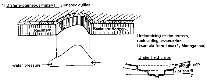
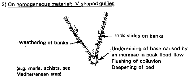
FIGURE
53
Forms of linear erosion
THREE PROCESSES OF GULLY FORMATION
1) On heterogeneous material: U-shaped gullies
2) On homogeneous material: V-shaped gullies
3) On swelling clays, gypsum and soluble materials: tunnel gullying
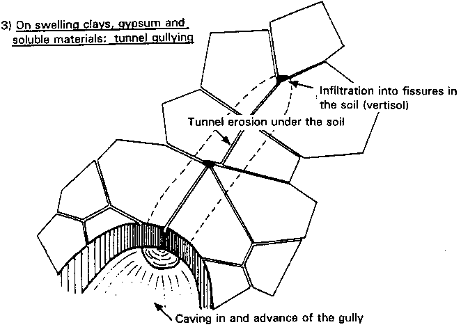
Gully shape is also important. Some are V-shaped, with an even slope down to the lowest point, others are U-shaped, with vertical sides, and still others develop through tunnelling and subsidence (Figure 53). Large or torrential gullies are those in which floods are so violent and frequent and sediment transport so extensive that there is no hope of establishing plant cover in their bed within a reasonable timeframe. Examination of the bed itself completes the diagnosis. The bed of a torrential gully is usually blocked with coarse alluvial deposits, and there is very little woody vegetation. On the other hand, in small gullies which will respond to biological treatment, alluvial deposits are finer and woody vegetation is still found in some sections - so long as the degradation of such vegetation has not been too much exacerbated by cropping (Lilin and Koohafkan 1987).