TRADITIONAL FARMING TECHNIQUES
In times past the Minianca traditionally used the sandy and even the gravelly land at the top of hills, building their villages on lateritic ironstone in order to avoid being surprised by possible enemies. Nowadays, with mechanization and animal traction, they prefer to farm the loamy-sandy sloping pediments, and tillage is confined to one passage with the plough and two with the hoe, mounding at the same time.
Animal husbandry is always extensive. During the rainy season a shepherd (often an outsider) takes the village animals to the grazing lands. During the dry season livestock live off crop residues and any greenery remaining in the valley bottoms.
In the evening cattle are gathered in paddocks protected by a dead hedge. Dried dung trodden into powder by the animals' feet accumulates in these paddocks. Wood requirements have so far been met by taking it from the rangeland. In the cultivated area there is still a stand of karité, locust bean, and occasionally Faidherebia albida. The valley bottoms are still little used, except for rice production where wide enough, and fodder at valley heads in the dry season. The farmers are aware of the steady degradation of their environment due to the increasingly intensive cropping of cotton and cereals, and are anxious to protect the cultivated areas from runoff from rangelands and the considerably degraded lateritic hills.
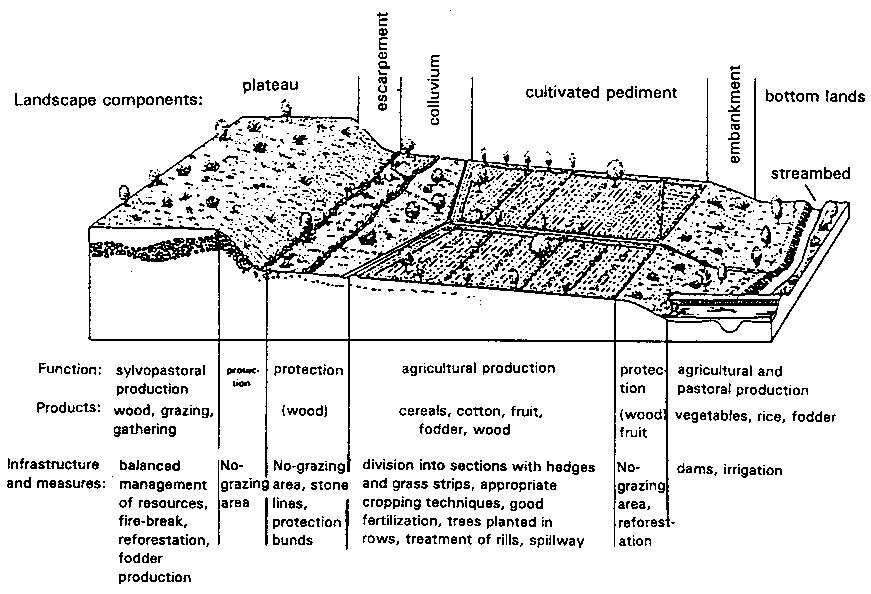
FIGURE 62 Diagram showing improved use of a hillslope in Minianka country: an example of rainfed farming proper (cf. Hijkoop, Poel and Kaya 1991)
ANALYSIS OF LOCAL CONDITIONS
Rainfall gradually decreases from 1000 to 700 mm. Maximum monthly rainfall is 250 mm, and drainage decreases from 200 mm to practically zero. Wischmeier's RUSA erosivity factor varies from 350 to 500, and the highest daily rainfall at ten-yearly intervals is 120 mm. The ferruginous, tropical, loamy, fairly unacidic, undesaturated soil is fragile and vulnerable to rainsplash. As in the previous cases, the landscape is composed of lateritic hills or granite domes followed by scree slopes, and in this case very long sloping pediments (several kilometres) ending in steep banks or valley bottoms of varying widths, degraded through overgrazing.
HAZARDS
The dangers on the gravelly soil of the hills come from degradation of the vegetation through overgrazing, which leads to a reduction in infiltration. Concentration of runoff leads to deep gullying which can severely scour the slopes. On the cultivated sloping pediments, apart from soil degradation through mineralization of organic matter and rainsplash, there is also gullying from the hills, the deposition of stretches of sand and gravel, and the skeletonization of the surface horizon from very frequent tillage. In the hydromorphic zone in the valley bottoms, the risks are those of degradation through overgrazing, gullying of the bed, and siltation from gullies spanning the entire cultivated area.
SUGGESTED IMPROVEMENTS (Figure 62)
Runoff on the ironstone uplands must be checked by stone lines, grass and forage bushes regenerated, and fodder resources restored. At the bottom of this area, cisterns could be dug in front of the protection dikes that now collect runoff water over 400 metres and lead it toward spillways to divert it during the excessive rains of August. The spillways double as paths during the cotton harvest in the dry season.
In the zone of the broad sloping pediments, grassed spillways are needed to divert runoff and to bring out the harvest. Plots must be bordered by hedges and trees, organic matter and nutrients balanced on plots, and full absorption encouraged through deep tillage followed by tied mounding. In the valley bottoms fertility must be restored through organic manure and fodder crops to improve the production of fruit and vegetables. And in the rice-growing sections, a second, dry-season crop could be grown, allowing deep-rooting plants to draw on water stored deep in the soil. This last section can be improved by using bunds made of earth and clumps of grass to help level each plot perfectly. The main problem in these lowlands is often the flooding caused by heavy rains, and a central channel is therefore needed to drain the whole valley bottom.
TRADITIONAL FARMING TECHNIQUES
Mossi farmers behave like pioneers, clearing and burning nearly all the trees, save a few acacias, Sclerocarya birrea, baobabs, etc.
At the time of the first storms of the rainy season, and without tilling the soil, they drill-seed sorghum on the best land and millet (plus some groundnut and cowpea) on sandy or gravelly land, in holes every metre. They resow as many as five times if necessary and then hoe once or twice. On the sandy soil in the north, hoeing is combined with clearing around the roots, thus improving infiltration around the clumps of millet.
The farmers treat exhausted soils with applications of organic material (2 to 5 t/ha of dried, powdered paddock dung and household ash) or a mulch of cereal stalks and branches of pulses unattractive to livestock, such as Piliostigma reticulatum and Bauhimia refuscens, and then leave the land as grassland.
They use the zaï method to restore exhausted land, catching runoff in a small pit that contains some organic manure. The tunnelling activity of termites allows this organic matter to trap 100 mm of water after the first storms (Roose and Piot 1984; Roose and Rodriguez 1990; Roose, Dugué and Rodriguez 1992).
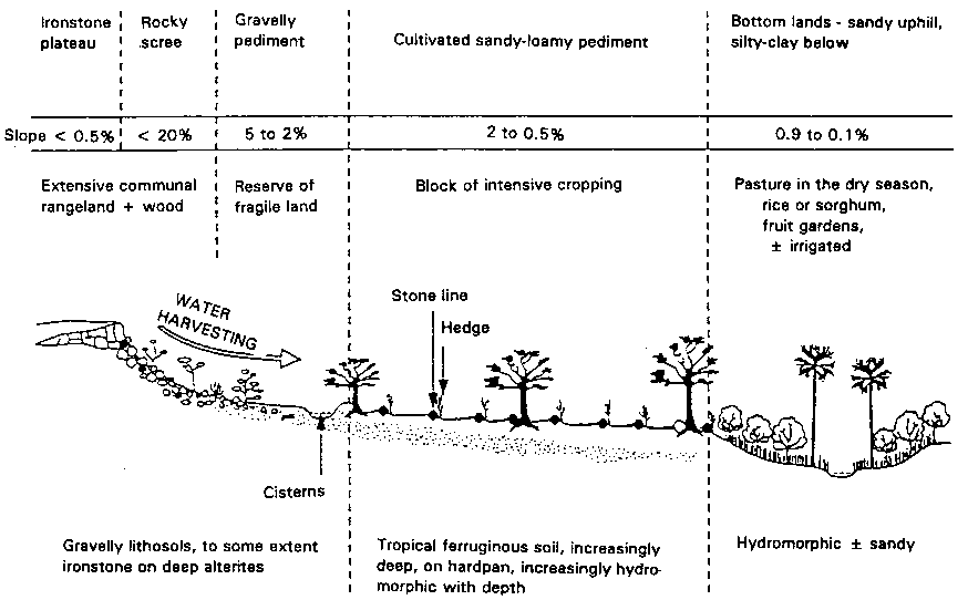
FIGURE 63 Diagram showing improved use of a granitic landscape on the Mossi Plateau: runoff farming
Poor soils: deficient in N and P, sometimes Km Ca, Mg and trace elements: pH 5 to 6.5
Fragile soils: slaking crust, poor infiltration, plough pans, poor in organic matter
Restoration of soil fertility (see saï): tillage + spot manuring + N. P. K supplements + control of runoff + sorghum or strong-rooting legumes
Improvements
Uncultivated water harvesting area
• Storage of runoff.
- ½-moons, microcatchment.
- cisterns for cattle, and for irrigating a garden
- hill lake in a favourable location
• No-grazing area (5-year contract).
- forage trees along the subsoiling line.
- grass behind the stone lines,
- protection against fires.
• Grazing organized by the community herder.
Rainfed crops
• Slowing runoff.
- hedges + trees along edges
- stone lines
- lines of Andropogon grass, every 10 to 25 m.
• Creating a bocage against the wind
• Dense, early sowing, tied mounds to enhance water storage.
• Irrigated gardens behind the cisterns.
• Cattle passage corridors.
• Rotation of cattle paddocks.
• Manure/compost pits near dwellings.
• Supplementary fertilization as required by crops
Irrigated crops + off-season fruit gardens
• Spreading flood water.
• Trapping fertile sediment.
- filtering dikes
- bunds build of sods/rice fields
- small village reservoir.
• Recharging groundwater to increase security in periods of drought.
• Avoiding large trees, which draw too much on groundwater.
• Maintaining a forage zone to act as a filter.
The traditional use of boulis or water tanks several dozen cubic metres in size, with the earth being dug out and spread downhill in a half-moon shape, also allows them to collect some of the runoff from the hills to water livestock near the rangeland and irrigate a small garden (Dugué 1988). Where land is short, the Mossi farmers use a system known as zipelle in which stone lines are arranged in a honeycomb pattern to rehabilitate eroded, bare and crusted surfaces where even natural vegetation can no longer grow through lack of infiltration. These lines of stones, grass or stakes slow down runoff and encourage the deposition of organic matter and coarse, permeable sediment. From the second year, the sandy horizon so formed is tilled, manured and planted - and as much as 800 kg/ha of sorghum is often harvested (Wright 1985).
As in the previous case, livestock are moved to the rangelands during the rainy season. After the harvest, the animals are fed crop residues, but are then left to shift for themselves, wandering over the area at will.
ANALYSIS OF LOCAL CONDITIONS
Annual rainfall decreases from 700 mm in the south to 400 mm in the north. Maximum monthly rainfall rarely exceeds 100 mm, and drainage is only occasional - between 50 mm and zero. Rainfall aggressiveness decreases from 400 to 200 on the RUSA scale, and the maximum rainfall in a single day over a ten-year period rarely exceeds 100 mm. The landscape is very like that in the previous case, but is composed of lateritic hills or granite domes, and very long, broad, sloping pediments with valley bottoms of varying breadths. On the hills, the gravelly lithosols are ironstone to varying degrees over deep alterite, and contain very little water. On the other hand, the deep alterites under the gravel sheets are moist throughout the year. The broad, sloping pediment is composed of leached, tropical, ferruginous soil, loamy-sandy on the surface and more clayey at depth. The valley bottoms are hydromorphic and sandy or loamy.
HAZARDS
As little is stored in the gravelly lithosols of the lateritic hills, overgrazing leads to degradation of the vegetation, which in turn reduces the activity of mesofauna, forms slaking and sediment crusts on the soil surface, and encourages heavy runoff leading to gullying. The cultivated sections often present an advanced degradation of soil fertility, acidification and skeletonization of the surface horizon, which becomes very sandy, easily eroded and vulnerable to rainsplash. Sand and gravel from gullying on the hills are also deposited on these sections. The soil has a very depleted stock of nutrients, so that crops must be nourished as and when needed. The general degradation of the soil in the valley bottoms through overgrazing and cropping with no restoration of organic matter or nutrients is also to be deplored. Added to this, the gullies upstream lead to gullying of the river bed and/or generalized siltation of the valley bottom. The broad bottom lands are difficult to manage, since they are flooded for several days during the heaviest rainstorms two years out of three.
SUGGESTED IMPROVEMENTS (Figure 63)
Improvement of the rangelands on the ironstone hills and gravel pediment may be achieved by reforestation with the help of forage shrub species, if a partial ban on grazing can be organized for five years. Such improvements can be assisted by slowing runoff with stone lines and replanting grass, first scratching the dry ground with a pronged subsoiler, and spreading organic debris (twigs, bark, straw) or stones to trap water, sand and seeds. If the soil is too degraded, subsoiling along the tree-planting lines can have a lasting effect, at least on the gravelly pediment. Lastly, runoff storage can be improved either by building half-moons or total absorption ditches, or by digging out the cisterns known as boulis to obtain water for livestock or for irrigating a small garden.
With respect to the cultivated area on the loamy-sandy pediment, stop-wash lines can be set up every 20 to 25 m, and hedges planted around the fields, with trees every 5 m to build up a stock of karité, Acacia albida and various pulses. The stop-wash lines can be made of rows of stones or grass, the long-term objective being the creation of a landscape in which sufficiently large crop fields are surrounded by hedges so that livestock can be kept on the fields during the periods when the animals eat crop residues, or off them when the soil has been prepared and the crops are growing.
In the irrigated valleys, filtering dams built at valley-heads will spread flood waters, trap some of the water and sediment, replenish the water table, and increase food security by providing off-season water to vegetable and fruit gardens. Where the valley is larger, with a catchment area of several square kilometres, earth bunds can be built to retain enough to provide water for the village. This method of semi-pervious microdams improves yields and contributes to the food security of these very poor regions which have practically no cash crops. Furthermore, the suggested improvements are very inexpensive and within the reach of any farmer.