TRADITIONAL FARMING TECHNIQUES
In this zone with under 400 mm of rainfall, conditions contrast greatly with those in Sudanian zones. Rainfall is more erratic and falls on a small area. While there are several methods of collecting rainwater or runoff to grow trees and cereals in the wide runon areas in the Mediterranean environment of the northern Sahara where rain falls during the cold season, water conservation strategies are few and less easily apparent in the tropical Sahelian zone where rain falls in the hot season. Strategies focus on choosing crops according to the soil (millet on sand, sorghum on loam and in the bottom lands, and irrigated gardens around the wetlands) and on taking advantage of storms when these occur (very light tillage, but with repeated sod-seeding, requiring very little seed [3 kg/ha] or work [9 h]) with large areas being sown, although a good proportion may be abandoned when it comes time to do the hoeing.
A frequent survival strategy is short-distance migration in order to gather wild crabgrass or water-lily bulbs. Homes are on the cultivated fields from November to August, near granaries and milking places. Herds are systematically moved to temporary pastures.
This region depends essentially on the extensive pasturing of herds, which are moved as seems most advantageous. The use of crop residues and even animal excrete as fuel demonstrates the severe lack of wood in this zone.
ANALYSIS OF LOCAL CONDITIONS
Rainfall varies from 400 to less than 150 mm, the maximum monthly rainfall is roughly 175 mm, drainage is calculated as nil, the erosivity factor is under 200, highest daily rainfall in a ten-year period is 80 mm, and the population density drops sharply to less than 10 per km².
The landscape is composed of dioritic hills followed by a broad, sloping, sandy, then loamy, pediment, terminating in the region of the pond. Small dunes form around clumps of grass and bushes on the sandy pediment. Some old Faidherbia albida and other thorny vegetation still survive on the loamy pediment, especially where the water table is not too far down. Soil is lithomorphic on the mountains and sandy on the dunes, with sub-arid, brown-red soils around the marshes. Traditional techniques entail flat-sowing millet on sand and sorghum on the clayey lowlands, and using the slopes as extensive pasture. Gardens are planted in the lowlands, with a certain amount of flood recession cropping all around the pond.
HAZARDS
The main risk in the sandy zone is wind erosion along with degradation of vegetation from both overgrazing and the wind erosion. Rainsplash on the sloping loamy pediments results in very extensive runoff, which digs small gullies.
SUGGESTED IMPROVEMENTS (Figure 64)
In this extremely fragile environment, it is dangerous to advise the development of an agropastoral system to match population growth. Development appears to be blocked today, since almost all the possible land is now being farmed. Fallow periods are disappearing, the soil is becoming exhausted, and the cost of inputs (mineral fertilizers and short-cycle varieties) is only economically viable in years when rainfall is abundant and well distributed. However, the following measures could be tested on an area such as that at Ségué in northern Yatenga:
• planting hedges or thorny fodder species in sandy areas (Balanites, Acacias albida, Acacias nilotica, etc.);
• microcatchment water-harvesting for small ridged fields on loamy pediments;
• agroforestry in the bottom lands (stone lines, hedges, forage and fruit trees);
• organizing the shores of ponds and marshlands for diversified intensive cropping (fodder for dairy production, cereals, vegetables and some fruit trees).
However, it is clear that agricultural production is restricted to the lowlands and that animal husbandry with short-distance nomadism is better adapted than cropping to this very fragile Sahelian environment.
FIGURE 64 Diagram showing improved use of a Sahelian landscape (R > 400 mm): example of an agropastoral system in which intensive farming is confined to the valley: valley farming
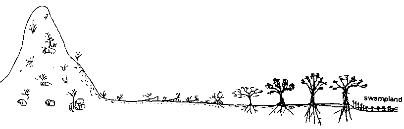
Water harvesting area and
rangeland |
Rainfed random crops under old
trees |
Intensive irrigated or
falling-flood crops |
dunes or sandy deposits |
loamy pediments |
edge of the valley or swampland |
lithosols |
red-brown semi-arid soils |
fairly fertile hydromorphic soils |
Poor soils: deficient in N and P. poor in organic matter, risk of salinization
Fragile soils:
slaking and erosion crusts
permeable if covered by a sheet of sand
quickly becoming sealed on loams
Hazards: |
rainfall impact on soil (r) scouring |
splash erosion, degradation of
organic matter and gullying |
hydromorphism, surface salinity |
wind erosion on sand |
Improvements
- Large area for water harvesting |
- Supplementary
irrigation from groundwater fed by runoff |
|
- Extensive rangelands |
||
- 1/2 moons or zaï for planting
millet and shrubs |
- Larges Acacia
with roots down into groundwater |
|
- Some millet cropping on the
sandy deposits |
- Millet-groundnut or cowpea
rotation |
Intensive irrigated fruit and
household plots |
- Harvesting runoff to form small
ponds to water livestock |
- If possible, thorny hedges: Acacia,
Euphorbia balsamifera, or perennial grasses - Andropogon. |
Fodder crops in and around
swampland |
- Stabilizing the sandy deposits
with bushes so as to minimize the risks of damage to
neighbouring crops from sheets of wind-blown sand |
||
TABLE 39
Variety of environmental
conditions along a bioclimatic belt in West Africa, and range of
suggested control methods (cf. Roose 1992)
Ecological zone Rainfall Case
studied |
Guinean forest 2500 to 1200 mm
in 2 seasons (Abidjan) |
Southern Sudanian 1400 to 1000
mm in 1 season (Korhogo) |
Northern Sudanian 1000 to 700
mm Koutiala |
Southern Sahelian 700 to 400 mm
Ouahigouya |
Northern Sahelian 400 to 150 mm
Mare d'Oursi |
Mean annual rainfall |
2100 mm |
1350 mm |
900 mm |
725 mm |
535 mm |
Monthly rainfall max. |
700 mm |
318 mm |
250 mm |
207 mm |
177 mm |
Daily rain 1/1 1/10 1/100 |
135-230-280 (mm) |
76-119-169 (mm) |
62-107-166 (mm) |
55-101-146 (mm) |
49-79-109 (mm) |
Max. intensity 1/1 1/10 |
90-120 (mm/h) |
75-106 (mm/h) |
60-80 (mm/h) |
59-78 (mm/h) |
32-45 (mm/h) |
Rain erosivity RUSA |
1260 |
675 |
420 |
360 |
260 |
PET (mm) |
1250 mm |
1660 mm |
1750 mm |
1905 mm |
2000 mm |
Calculated drainage |
1200-800 mm |
470-160 mm |
180 to 10 mm |
50 to 0 mm |
0 mm |
Diagnosis of risk: |
|||||
- leaching, acidification |
+ + + + |
+ + + |
+ + |
+ + |
- |
-sheet erosion |
++++ |
+ + + |
+ ++ |
+ + + |
+ + (on pediments) |
- gully erosion |
++ |
+++ |
+++ |
+ + + |
++ (on pediments) |
- waterlogging |
bottom lands |
slopes and bottom lands |
bottom lands |
bottom lands |
bottom lands |
Soils on the slope |
very desaturated ferralitic SC ±
gravelly very acid |
- ferralitic, desaturated ±
gravelly |
- ferruginous leached SC ±
gravelly |
- ferruginous leached SA ±
gravelly |
- ferruginous, little leaching,
sandy on dunes |
Vegetation |
Closed rainforest + Panicum,
etc. |
Tree savannah, Daniella,
Parkia, Butyrospermum + Andropogon + various |
Tree savannah, Parkia,
Butyrospermum + thorn species + Andropogon +
various |
Shrub savannah with Combretum,
Baobab, acacia + thorn species Andropogon +
various Pennisetum |
Steppe or bush baobab, acacia, Balanites,
Ziziphus annual grasses |
Farming systems |
Cover farming Complete/Full/Total
infiltration |
Drainage farming during the 2
wettest months |
Rainfed farming = total
infiltration of rain |
Runoff farming |
Valley farming: concentration of
water and crops in valleys |
Population density (pop/km²) |
20 to 40 |
30 to 100 |
30 to 50 |
70 to > 100 |
10 inhab/km² |
Traditional techniques |
- multicropped cassava + maize +
herbs on small mounds |
- yams on large mounds |
- flat-grown crops + 1 weeding + 1
mounding, sorghum/cotton or millet/ groundnut/cowpea |
- sod seeding on the flat after
burning, then 1 weeding and 1 mounding: sorghum or
millet/groundnut/cowpea |
- sod seeding on the flat + 1
weeding and loosening around roots |
Treatment proposed |
Land husbandry |
SWC (1964-68) |
Land husbandry 1985-91 |
SPR of GERES 1960-65 |
Land husbandry |
CONCLUSIONS The above overview of this bioclimatic sequence indicates that development of farming techniques tailored to the water balance should go hand-in-hand with appropriate water management methods for erosion control (see Table 39). This makes it easier to understand one reason for the failure of the many SWC and SPR projects which have stubbornly applied the model developed by Bennett at another time, in a temperate climate, and under intensive mechanized farming. It is also easy to understand traditional farmers who not only fail to maintain imposed erosion control schemes but actually destroy them when they come to realize that they are unsuited to their special farming conditions. Analysis of both traditional strategies and the monthly water balance could provide a basis for future land use planning projects, which must focus on improving such strategies with the active involvement of farmers and herders. This
is a challenging, long-term research and development
task, in which the human aspects are as important as the
technical ones. Multidisciplinary teams will therefore be
needed to monitor and evaluate such projects. |
Chapter 10. Development of the Bamiléké bocage
EXAMPLE OF TRADITIONAL ADAPTATION TO STRONG POPULATION PRESSURE
Jean-Marie Fotsing, Head of Geography Department, University of Yaoundé, Cameroon
The situation
Diagnosis: relatively fragile environments
Effective traditional techniques
Hazards
Some suggested improvements
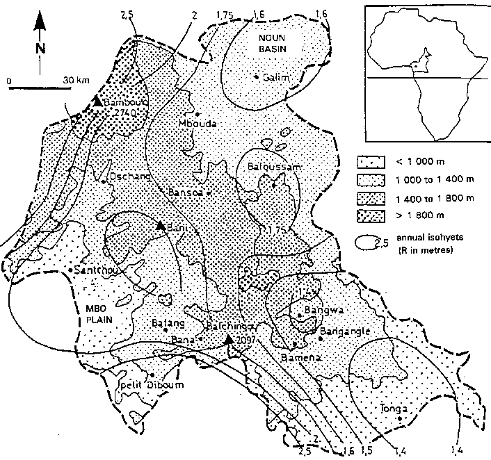
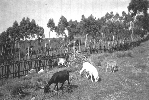
Situated in Central Africa between 5° and 6° N. the Bamiléké uplands occupy 6196 km² to the south of the highlands of western Cameroon (Figure 65). With an average population of 168 per km² reaching 600 in some places, it is one of the few tropical regions supporting such a large population on traditional rainfed farming. Analysis shows that the farming techniques are relatively effective in maintaining fertility and controlling erosion. However, current changes in the region are leading to a simplification of techniques in areas long occupied and to an expansion of these same farming methods to recently developed areas. Heavy population pressure, increasing numbers of dwellings and contemporary social and economic demands may well have adverse effects on a fragile environment; even the relatively unaggressive rainfall tends increasingly to accumulate on the surface, and the ensuing runoff threatens farmed slopes. What is the answer? Is it possible to envisage a heavily populated, productive and stable mountain area? The partial success of the Western Province Rural Development Project - which included digging erosion control ditches, building bench terraces on the slopes, and applying mineral fertilizers - encourages consideration of solutions based essentially on local know-how in an environment with considerable agricultural potential.
Diagnosis: relatively fragile environments
UNDULATING LANDFORMS MARKED BY STEEP SLOPES
The Bamiléké region is a high plateau at an average altitude of 1450 m. It can be divided into three main sections, ranging from 700 to 2740 m (Figure 65).
Up to 1100 m, the peripheral plains (Noun in the east and Mbo in the southwest) occupy nearly 20% of the area. The flat surface is relieved by small gentle hills (less than 12% slope).
FIGURE 65 Relief map showing rainfall distribution (cf. Suchel 1989)
Between 1100 and 1600 m, the uplands constitute the main relief pattern, accounting for more than 70% of the region, with two distinct types:
• the granito-gneissic plateau in the south, with polyconvex or half-orange landforms, and occasional granite outcrops;
• the basaltic plateau in the north, with more even landforms, in which the land between the rivers has flattened, rounded or elongated hillocks, separated by narrow valleys; slopes steeper than 25% and those between 12 and 25% are predominant.
Above 1600 m, the mountains (less than 15% of the area) exhibit a more rugged topography, with 75% of their area on slopes of over 25%. This category covers the small granite mountains rising to less than 2100 m in the south, and the volcanic Bambouto chain in the northwest which rises in steps to a maximum of 2740 m.
UNAGGRESSIVE RAINFALL ON VULNERABLE SOILS
The climate is subequatorial monsoon in type, chiefly moist and cool, with one rainy season from mid-March to mid-November. Annual rainfall is everywhere over 1400 mm (Bangangté 1457, Bafang 1731, Bafoussam 1796, Santchou 1727, Dschang 1919, Baranka 2500), although it decreases considerably from west to east, and also from south to north due to altitude. The peak rainfall levels are in August and September; in Bafoussam, for example, they reach 90 to 11.6 mm in March, April and May, and 118 mm in August. However, hourly intensity is low (15 to 40 mm/h). Temperatures are kept down by the altitude (in Bafoussam maxima are between 23° and 27° C).
Soils can be divided into three groups (Champaud 1973, Segalen 1967):
• ferralitic soils derived from basalt are the most widespread, with very favourable physical and hydric properties - great depth, high porosity, friability without gravel, a high clay content, and surface permeability; hardened ferralitic soils with occasional outcrops of ironstone;
• relatively unevolved soils derived from basic soft volcanic rock (ash, lapilli), very rich in organic matter, nitrogen and exchangeable bases, and very permeable;
• hydromorphic soils - sandy and deficient on granite, peaty on basalt and alluvial deposits - are found in the marshy lowlands; they are not particularly fertile, but the presence of water, flat topography and high organic matter content makes for good farmland.
Soil texture is very varied, with silt content ranging from 10 to 30% and clay from 10 to 70%. However, whatever the soil make-up, local variations depend on the position in the toposequence. Generally speaking, soils are deeper, finer and more fertile on the lower slopes than on the higher reaches. The traditional farming techniques and organization of farmland reflect these local variations.
STRONG POPULATION PRESSURE, ALTHOUGH VARYING IN ACCORDANCE WITH GEOLOGICAL SUBSTRATUM (Figure 66)
The Bamiléké country has been inhabited for a long time and is densely populated, with an average of 168 per km² (1987). This figure means very little, however: density everywhere in the basalt region is higher than 200, in some areas approaching or even exceeding 1000 (Ducret and Fotsing 1987), while outside the basalt region it rarely exceeds 150, with the lowest densities in the alluvial zones and in mountain areas.
Population pressure is accentuated by the fact that dwellings are scattered, and also by the inheritance system: one male inheriting the entire family landholding. Non-inheriting sons therefore become founders of new lineages and have to find land for themselves elsewhere. With an annual growth rate of 3.2%, there is no let-up in pressure on land, despite a massive exodus toward the towns.