3. Desertification and drylands development in CIS countries
A. Definitions
B. Theories and hypotheses
C. Methodology and approaches
D. Large-scale development projects for arid and se -arid lands in the USSR - "Conquest of the deserts"
E. Phenomena of desertification
F. Causes of desertification
G. Impact of desertification and drylands development on the environment and on socio-economic conditions
H. Drylands development and combating desertification
I. Results of large-scale projects in drylands development and combating desertification
3.1 In studying changes in the natural environment of arid and semi-arid regions, researchers often discern two processes: "desertization" and desertification. This is particularly true in the French school of thought. In the USSR, almost all the literature concerned with Desertification has been written in Russian. The term "opustynivaniïe" is used, and is considered by Soviet and post-Soviet researchers to be a synonym for Desertification (cf. bibl. entry 67). Researchers in the Institute of Deserts have not found a Russian language equivalent for the term "desertization"; therefore, they have introduced the term "dïesïertizatsiïa. " This term has not entered the Russian language and we have not seen it outside the work noted above.
3.2 B.G. Rozanov's definition (cf. bibl. entry 52) is the most widely-used. He formulated it in 1977 when he wrote about the United Nations conference in Nairobi, and it can be found, occasionally somewhat modified, in a number of publications, including very recent ones (cf. bibl. entries 12, 60, 63, 90, 141). "Desertification is a natural or human-induced process of irreversible change in the soil and vegetation of drylands zones, towards aridification and a reduction in biological productivity. In extreme cases this process can lead to a total disintegration of the biological potential, and the transformation of the territory into desert."
3.3 Another definition is used by some scientists at the Institute of Deserts at Ashkhabad (cf. bibl. entry 3): "The intensification and/or expansion of desertic conditions constitute a process which leads to a decrease in ecosystem productivity; this decrease, in turn, leads to a decrease in pastoral resources, agricultural productivity and the quality of human life."
3.4 It is S.V. Zonn (cf. bibl. entry 146) who perceives the process of Desertification in the widest sense. In his opinion, it includes all processes of biological degradation whatever the cause and wherever they appear. According to this definition, Desertification can occur in any climate zone. S.V. Zonn identifies a number of Desertification types; in the Amazon there is the "technogeno-erosive" type, in the Maghreb the "erosive" type. However, Zonn's definition has not been accepted in CIS countries.
3.5 There are other definitions which interpret Desertification (opustynivaniïe) in a more limited way, but they are not widely accepted either. Three examples are noted below:
(i) Desertification is the process of the expansion of desert surfaces, notably due to sand movement. It occurs in a narrow band of semi-desert which directly borders on desert. This definition is rarely encountered, and then almost exclusively in the early specialized literature of the 1960's and 1970's (cf. bibl. entry 111). Although it is extremely rare in newer works, it has not disappeared, as is shown in the 1992 publication of Gorshkov V.S. and Losiev K.S. (cf. bibl. entry 91);
(ii) Desertification is the deterioration of the biological conditions of deserts (due solely to human activity), and their transformation into deserts devoid of life (cf. bibl. entries 38,65). It would be suitable in this case to use the term "desertization," or more precisely "desertization due to human activities;"
(iii) Desertification is a term covering an entire group of processes of degradation in arid and semi-arid ecosystems which result from irrational human activity.
3.6 The fact that these definitions emphasize human activity can be explained by the general conviction in Central Asia that it is not a natural evolution of the climate towards acidification; man is considered to be the cause of the degradation of the natural environment.
3.7 The theoretical considerations forming the basis of a systematic definition of desertification and the typology of the processes of desertification have been principally developed by I.S. Zonn in recent years. An analysis of his work (Cf. bibl. entries 34, 59, 60, 143) shows that the author is not seeking to clarify a coherent group of definitions, but rather is experimenting with them. However, he remains consistent in treating desertification as a process. Since every process occurs in time, it can be described in the form of a temporal function O(t) of desertification: 01 (to) = <xo * yo *zo> (x: climate; y: soil; z: vegetation cover; t: time).
Desertification occurs when the critical threshold values, not specified by the author, are exceeded.
3.8 According to I.S. Zonn it is very important to distinguish between processes of cause and processes of effect. If, for example, irrigation is a causal process, it brings on various effect processes: erosion (caused by irrigation), soil salinization, the formation of ponds and estuaries by infiltration, the formation of wholes in the soil, the raising or lowering of the water table, changes in the albedo of the soil surface, etc. The processes of effect, on the other hand, cause changes in the condition of the soil, ground and surface water, vegetation and climate. Processes of cause, processes of effect, and static conditions should not be confused. He reproaches the typology of the World Desertification Map (UNEP/FAO/UNESCO, 1977) in this sense.
3.9 Authors in the ex-USSR and the CIS of today commonly use the concept of desertification caused by technology leading to the degradation of ecosystems in arid and semi-arid zones. This degradation results, for example, from road construction, railways, mines and other large infrastructures. This type of desertification is very widespread in the countries of the USSR/CIS (cf. chapter 4E). It is therefore not surprising that a number of authors acknowledge taking this into account in the preparation of desertification maps or including it in estimations of surface areas affected by desertification (cf. bibl. entries 10, 17, 36 and others).
3.10 Soviet researchers work mainly on issues of desert "osvoïeniïe. " Literally, this term means "domestication," but can also be translated as "reclamation" or "management." However, desertification issues are also dealt with in studies of the natural environment of deserts, semi-deserts and steppes, and the changes which follow their management.
3.11 Great importance is given to chemical analyses, to work on the nutrient cycles in the environment and on changes in the chemical composition of soil and water. This is particularly true in studies of the far-reaching effects of salinization. There is a very interesting methodological approach in describing the salt cycle in the environment, which also takes the atmosphere into account (salt deflation, salinization in connection with winds over salty lands -cf. bibl. entries 33, 44, 94, 102, 110, 127).
3.12 Importance is also given to experimental studies carried out in field stations where, for the last several decades, changes occurring in nature have been observed. The best-known station, which records a large number of information, is that of Repetek in Turkmenistan. It has easy access to the Karakumy Desert which is about 50 km. from the Amu-Darya River. This Station was created in 1912; during the period between the two World Wars and it was a field station of the Academy of Sciences of the USSR where mainly Moscow scientists worked. Afterwards, it was incorporated into the Institute of Deserts of the Academy of Sciences of Turkmenistan when the latter was created. This station has undertaken most Soviet projects dealing with sand deserts and their typology, water cycles, vegetation, and sand dune fixation. Repetek was also a field station for research carried out in the central part of the Amu-Darya valley, which explains why that zone has been particularly studied.
3.13 Aerial photographs and satellite imagery have been used a great deal in studies of changes in the natural environment, particularly in desertification studies. Soviet scientists were in a privileged position: they were able to use universally accessible imagery from the satellites Landsat and Spot as well as those from exclusively Soviet satellites (Kosmos, Meteor). Among other things, satellite imagery is used to prepare vegetation maps and record vegetation changes, draw -up maps of soils, of salinization, of sand dunes, of hydrographic changes, and changes in the countours of the Aral Sea. Desertification maps, developed using remote sensing, are the most important accomplishment of this sort of work. In some documents, results obtained from different satellites are compared (cf. bibl. entries 10, 23, 35, 66, 74). Desertification maps are drawn up at different scales, for example the relatively detailed maps of southeastern Turkmenistan and of the lower Murgab River, and the very general map of all of ex-Soviet Central Asia. This latter well illustrates the technical quality of the maps and graphics included in Soviet scientific books and articles.
Figure 1: Desertification in southeastern Turkmenistan
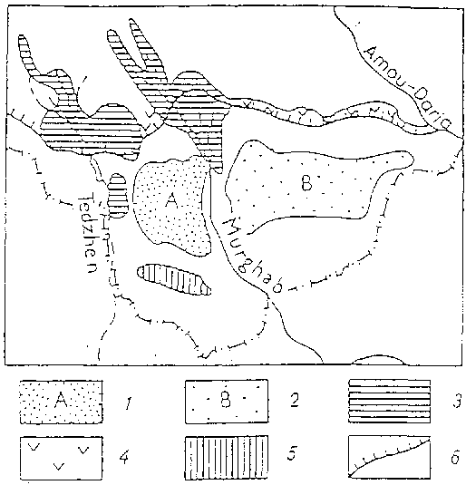
| 1 - | Patches of desertification in the area between the Tedzhen and Murgab Rivers; |
| 2 - | Patches of desertification in the area between the Murgab and Amu-Darya Rivers; |
| 3 - | Oases partially affected by salinization; |
| 4 - | Desertification along the Karakumy Canal; |
| 5 - | Pasture reserves; |
| 6 - | Karakumy Canal. |
Figure 2: Schematic map of desertification caused by human activities in drylands of the USSR (present conditions)
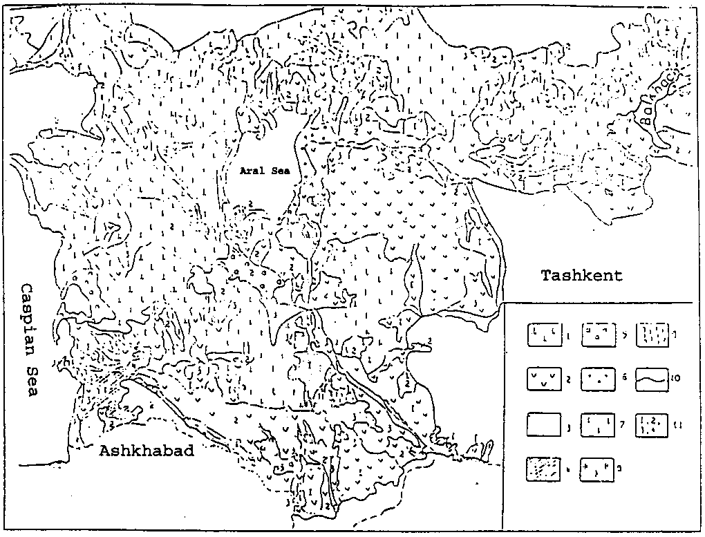
| 1 - | Areas not affected by desertification; |
| 2 - | Degradation of vegetation; |
| 3 - | Wind erosion; |
| 4 - | Riverbed erosion; |
| 5 - | Salinization in irrigated lands; |
| 6 - | Soil salinization due to the decline in the sea and the regulation of the flow of streams and rivers; |
| 7 - | Desertification caused by technology; |
| 8- | Solonchaks; |
| 9 - | Sand dunes of natural origin; |
| 10 - | Limits of the drylands zone; |
| 11 - | Degrees of desertification (1: light; 2: moderate; 3: strong; 4: extreme). |
3.14 Compared to the numerous projects on the natural environment and the physical features of desertification, there are few works on its social and economic aspects. These are generally texts: (i) where studies in other countries are described (cf. bibl. entries 16, 63, 73, 111); (ii) where the economic success of the Soviet Union in desert management is discussed; or (iii) where very brief information is given in passing on the losses and failures that have taken place before the success to come in future phases of the "conquest" of the desert. It is only in the last few years, as a result of the problems of the Aral Sea, that more publications have appeared on the social and economic aspects of desertification.
3.15 There is an interesting group of work on «formerly irrigated lands» in Central Asia. The irrigated lands of the past (especially in the 13th and 14th centuries, occasionally until the middle of the 19th) were much more extensive than those irrigated today. Specialists consider these lands particularly suitable for future irrigation. For this reason they have been identified (using remote sensing, and other methods), and their soils are scrupulously studied.
3.16 The uniqueness of the process of desertification in the ex-USSR is due to the fact that it is related to enormous programmes of desert "conquest" and management, characteristic of the Soviet period. These include: (i) the transformation of the steppe into arable land; and (ii) the construction of extensive irrigation systems and the development of the monoculture of cotton in Central Asia.
3.17 Although agriculture began in the steppes several centuries ago, it is only the programmes started in 1954 which have had a significant effect on the natural environment. In the first six years, 40 million hectares were ploughed by large, heavy tractors. After 1960, ploughing in the steppes slowed as the activity moved east. After ploughing the steppes in the European part of the USSR, work began in Kazakhstan and in southern Siberia. Today, approximately 75% of the total surface of the steppes has been ploughed. A large part of the steppes later became unfit for cultivation.
3.18 Irrigation development programmes were not begun with the same enthusiasm, although they intensified in the 1970's and early 1980's. The extent of these projects is presented in the following table:
Expansion of the area irrigated in the Soviet Republics of Central Asia (in thousands of ha)
YEARS |
1970 |
1980 |
1985 |
1990 |
| REPUBLICS | ||||
| Uzbekistan | 2696 | 3476 | 3930 | 4155 |
| Turkmenistan | 643 | 927 | 1107 | 1245 |
| Tajikistan | 518 | 617 | 653 | 694 |
| Kyrgyzstan | 883 | 955 | 1009 | 1032 |
Source: Narodnoïe khozïaïstvo SSSR v 1990g. Statistïchïeskiï ïejïegodnik (The national economy of the USSR in 1990. Statistical yearbook) Gostkomstat SSSR, Moscow 1991, p 490
3.19 In the entire USSR, the surface area irrigated increased from 10.8 million hectares in 1970, to 17.5 million hectares in 1980, 19.9 million hectares in 1985 and 21.2 million hectares in 1990. This of course required an enormous water collection, which in 1988 was a total of 152.5 km3 divided by 46.2 km3 in Uzbekistan, 24.4 km3 in Kazakhstan, 23.3 km3 in the Federal Republic of Russia, 18.2 km3 in Turkmenistan, 9.1 km3 in Kyrgyzstan, and 8.7 km3 in Azerbaijan.
3.20 In the USSR the consumption of irrigation water in drylands was very high, on the average 8,900 m3/ha, with at least 13,300 m3/ha in Armenia, 13,200 m3 in Uzbekistan, and 12,800 m3 in Kazakhstan (according to Russian statistics, cf. bibl. entry 54).
3.21 During the 1960's, efforts were directed towards the implementation of a global management programme for the Golodnaïa Stïep' (the Steppe of Hunger) in Uzbekistan. This initiative was to be a model of modifying nature (cf. bibl. entries 12, 46, 67, 86). In the years 1923-1956 about 250,000 ha were irrigated. In order to irrigate an additional 246,000 ha, construction was begun in 1956 on the Golodnaïa Stïep Canal, with a main branch of 246 km in length, plus lateral canals. At the same time, constructions were begun on drainage canals, villages, railroads (93 km), roads (1,746 km), gas pipelines, cotton factories, etc. In the years 1961-1972, cotton harvests in the USSR increased by 650,000 tonnes, almost half of which came from the Golodnaïa Steppe. The population increased rapidly, reaching, in 1974, 113,000 (in 1878 the population was 2,000).
3.22 The Karakumy Canal (or V.I. Lenin Canal) was the other large project begun in 1954. The canal, which in the USSR was considered to be "the largest hydrotechnical construction in the world" measures 1,200 km in length (it was supposed to be 1,400 km but its last part was not completed). It collects water from the Amu-Darya (400m3/s) and takes it towards the oases of Murgab, Tedzhen, and other smaller ones in the Kopet Dag foothills. It is supplemented by approximately 2,000 km of small canals. Along the canal, 55 large state farms have been created, with areas from 27,000 to 650,000 ha each (cf. bibl. entries 12, 46, 49, 67). In addition to the development of irrigated agriculture, there is also a marked increase in livestock production in Central Asia.
3.23 However, the GNP per ha of irrigated lands, which increased from 1,430 roubles/ha in 1970 to 1,715 roubles/ha in 1980, has diminished since, in some republics even to levels lower than those recorded in 1970. Desertification caused by human action is very likely one of the causes of this decrease.
GNP per ha lands (in roubles)
YEARS |
1970 |
1980 |
1985 |
| REPUBLICS | |||
| Tajikistan | 1880 | 2409 | 2310 |
| Uzbekistan | 1563 | 1849 | 1553 |
| Turkmenistan | 1351 | 1479 | 1251 |
| Kyrgyzstan | 792 | 986 | 1046 |
| Average for the region | 1430 | 1715 | 1533 |
Source: M. Turnball, 1991, Soviet Environmental Policies and Practices, Dartmouth.
E. Phenomena of desertification
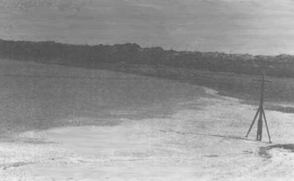
3.24 It has not been possible to find a publication which presents in a complete way the phenomena of desertification in the USSR. Based on various publications (cf. Index), the most important phenomena of desertification are (i) the deflation and mobilization of dunes; (ii) the salinization of soil; and (iii) the degradation of vegetation, notably around wells. The group of desertification phenomena related to the drying up of the Aral Sea affect Turkmenistan, Uzbekistan and Kazakhstan.
3.25 In addition to the above phenomena, there are others, such as soil erosion during the spring thaw (only occurring north of the steppes in western Siberia), the depletion of animal diversity, changes in the level of the water table, water pollution, etc. Quantitative estimations of the dimensions of desertification vary; the differences are sometimes very great.
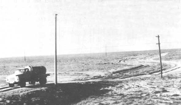
3.26 As for Central Asia (Uzbekistan, Turkmenistan) and Kazakhstan, one of the most reliable sources is the work of N.G. Kharin and A.A. Kiril'tsïeva (1988, cf. bibl. entry 36). They question the validity of previous estimations and establish the extent of lands affected by desertification at 60.2% of the area of these regions (Uzbekistan 59.2%, Kazakhstan 59.9%, Turkmenistan 66.5%). Regions affected by overgrazing cover 37.3% of the total area of these countries, partially decertified lands around wells represent 5.7% (18.6% in Uzbekistan). Zones affected by wind erosion occupy 3.3% of land, irrigated lands affected by salinization cover 1.3%, salinization due to the lowering of the level of the Aral Sea affect 5.3%, desertification caused by modernization 6.5%, and water erosion 0.7%. Desertification caused by modernization is mentioned in several works; it includes land degradation caused by motor vehicles crossing these regions, leaving a degraded strip of up to 1 km in width (cf. bibl. entries 10, 17, 64, 65).
Figure 4: Desertification caused by trucking in Kazakhstan (photo: F. Plit, May 1993)
3.27 Soil salinization in the ex-USSR has reached levels which probably exceed any elsewhere. It is therefore not surprising that this phenomenon is mentioned in nearly every publication concerning desertification, as well as in a number of works dealing more generally with the characteristics and processes of the natural environment.
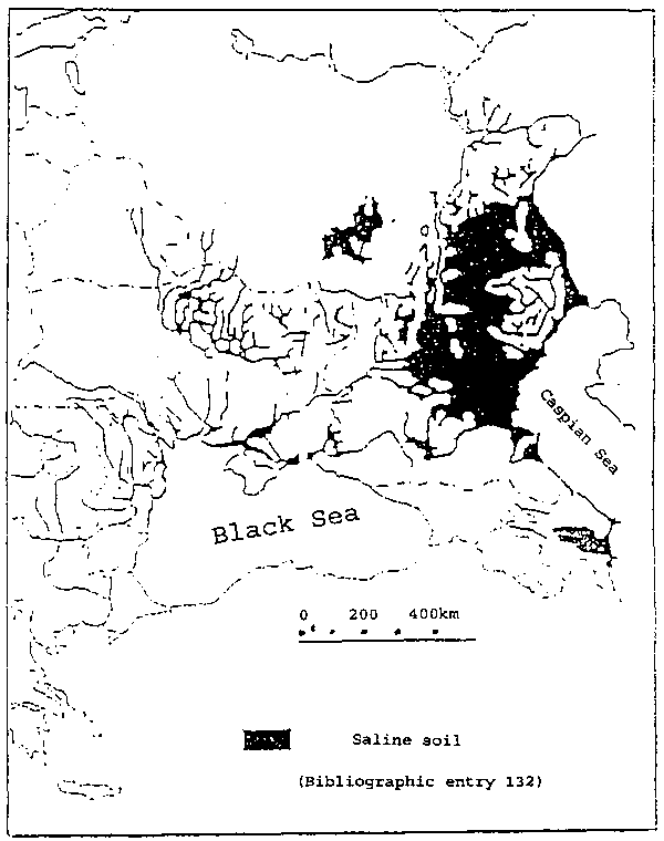
3.28 I. Szabolsc (1991, cf. bibl. entry 135) estimates at 29.5 million hectares the area of saline lands in the European part of the USSR (cf. map). In contrast, in all other European countries taken together, saline lands cover only 3 million hectares. Central Asia has the most salinization. Large white patches of solonchaks, just outside the irrigated zones, are visible both by train and by plane.
3.29 The deflation and formation of dunes is also frequently described (cf. index). In spring and autumn, at the time of the dust-storms, deflation reaches disturbing proportions. The regions most affected by deflation are: the southern Ukraine, the upper Volga, the Aralo-Caspian depression, northern Kazakhstan and southwestern Siberia, a total of 1.6 million km2. In certain areas, deflation already affects 2 to 7 cm of the topsoil per year; more than 20 days of dust-storm per year are recorded (cf. bibl. entry 50). During the heaviest storms, dust reaches as far as Poland and Hungary.
3.30 In the period 1961-1988, the nearly 15-meter decline in the level of the Aral Sea has bared 25,000 km2 of the former seabed. This has caused a lowering of the water table up to 200 km from the sea, the drying of lakes in the Syr-Darya delta and a decrease in the productivity of pastures (estimations vary, but the losses seem to be enormous: for example, in the Syr-Darya delta as early as 1975 only 0.8 million tonnes of forage could be harvested on 1.4 million hectares, compared to 3.6 million tonnes in 1960 (cf. bibl. entry 108). This has also caused sand deflation, dust (an increase in the number of dust-storms) and salts in the reservoir, which in turn contributes to an increase in soil salinization, up to 400 km from the sea. These salts even settle on the glaciers of the massifs of Alaï (Alaïskiï khrïebïot) and Zaalaï (Zaalaïskiï khrïebïot), causing them to melt.
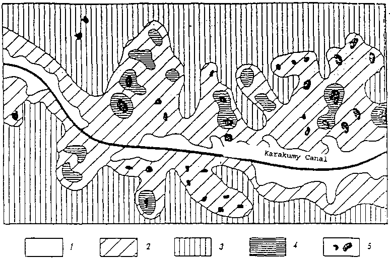
Figure 5: Environmental changes in lands near the Karakumy Canal (bibl. Entry 67): 1 - moving sands; 2 - sands partially stabilized by vegetation; 3 - sands stabilized by vegetation; 4 - marshes and wetlands; 5 - lakes caused by infiltration.
Map
3.31 Natural desertification, even as it occurs in CIS countries, has a very limited range. Although we have not been able to find publications which confirm the existence of this process, the climatic fluctuations of the past, variations in the level of the Aral Sea as well as the Caspian Sea, and the periodic functioning of large irrigation systems in Central Asia in Antiquity and the Middle Ages, leave one to suppose that slow natural processes are the backdrop for the very rapid desertification process that is happening today. Variations in the level of Central Asian reservoirs depend on a number of factors (the current transgression of the Caspian Sea is probably influenced by tectonic movements). However, it is without doubt human activity, especially errors made in the management of arid and semi-arid lands, which is the chief factor in present-day desertification. Publications emphasize above all the negative effects of the over-use of water resources for irrigation and other purposes (cf. bibl. entries 29, 43, 48, 79, 123, 127). In the early 1980's, use of water from the Amu-Darya was 70 km3 of the 79.5 km3 of all its water (87.6%); as for the Syr-Darya, water use exceeded the flow by 24% (by recycling the same water). In the 1960's the Aral Sea received an average of 55 km3 of water from the Amu-Darya, which decreased in the years 1978-1981 to 9-10 km3. In 1982, for the first time, water from the river did not reach the Aral Sea. In 1976, the same phenomenon occurred with the Syr-Darya. In recent years, water from these rivers reaches the Aral Sea only occasionally (for example, during the floods of 1992, cf. bibl. entry 29). By the end of the 1980's the Ili had practically stopped supplying water to Lake Balkhash.
3.32 Losses of irrigation water due to evaporation and infiltration from canals hundreds of km long, sometimes dug in permeable sand, are enormous. For example, in the area around the Karakumy Canal, several small lakes have formed. Rapid evaporation leads directly to salinization (cf. bibl. entries 12, 67, 110, 127). In Central Asia the production of a tonne of cotton requires 2,000 to 3,000 m3 of water; actual consumption is 1.25 to 1.75 times the acceptable norms and is greater than water consumption in other regions of the world (cf. bibl. entry 123). In some cases an increase in salinization is due to delays in the construction of drainage systems or their malfunction. In 1990 in the entire USSR, of the 23.1 million ha that were irrigated, only 18.5 million ha had drainage systems (bibl. entry 54). The construction of the Kapchagaï Reservoir in the Ili basin (bibl. entry 53) is a spectacular example of salinization caused by human action. Highly saline soil was submerged, which contributed to the salinization of the reservoir water. This water was then used for irrigation.
3.33 The main factors in wind erosion are believed to be the ploughing of the steppes and over-grazing. Considering the huge extent of deflation from the Aral Sea bed (it is estimated at 100 million tonnes per year), the development of irrigated agriculture can be seen as an important indirect cause. Dune formation is also caused by projects in which machines move large quantities of earth (for example, near the Karakumy Canal or next to mining towns), and by truck movements (their routes are visible - for example, next to Tashkent -from airplanes at an altitude of over 3,000m). Mining and the excessive practice of slash-and-burn in forests and brush formations are also factors in desertification.
3.34 B. Komarov (cf. bibl. entry 42) feels that the main cause of such severe land degradation is not so much the lack of appropriate regulations as it is the legitimization of an increase in production at any price and by the insufficient ecological awareness of decision-makers.
3.35 Despite the extent of desertification and the plentiful specialized literature these past years, the socio-economic impact of desertification remains little-known. Until 1989, information on this subject was very rare and was dispersed among articles dealing with other issues, generally biological in nature. An additional difficulty stemmed from the fact that until 1991, with the central planning of the economy, all attempts at estimating losses were marred by errors because of arbitrary price-fixing. Since 1991, hyperinflation has created difficulties in comparing data from year to year. The example of three calculations, cited by P.R. Pryde (cf. bibl. entry 50), demonstrates the differences in these estimations:
- in 1979, the sum total of losses since the beginning of large-scale irrigation in the Aral Sea basin, within Uzbekistan alone, is estimated to be between 5.4 and 5.7 billion roubles;
- in 1988, annual losses in the Amu-Darya delta (the two deltas of the Amu-Darya and the Syr-Darya are the most affected in Central Asia) are estimated to be only 100 million roubles per year;
- in 1988, the Soviet daily press published estimations according to which losses in the entire Aral region reached 1.5 to 2 billion roubles per year.
3.36 By contrast, according to estimations quoted by V.A. Dukhovnyïa and others (cf. bibl. entry 29), economic losses caused by harvest decreases alone in the years 1974, 1975, 1977 and 1978 (particularly dry years) reached 1.7 billion roubles per year.
3.37 It is for this reason that estimations of the impact of the processes of desertification are limited to information based on physical data which are very fragmentary and useful only as examples.
3.38 Authors emphasize the impact of desertification on:
(i) Agriculture: B. Komarov (cf. bibl. entry 42) shows that at the end of the 1970's, the area of lands rendered unfit for cultivation because of salinization and erosion caused by human activities covered 630,000 hectares in the entire country. In Kazakhstan, deflation caused losses in brown soil reaching 40
70%;(ii) Animal production: a decline in forage resources has caused a reduction in the number and the productivity of animals, particularly a decrease in the milk production of cows. For example, in the Kyzl-Orda oblast in Kazakhstan, as early as 1980, lactation decreased by half, to 998 kg/year in the kolkhozes (cooperative farms) and to 724 kg/year in the sovkhozes (State farms);
(iii) Other losses: the most important are (i) decline in the fish catch in the Aral Sea (from 50,000 tonnes in 1960 to 12,000 tonnes in 1970 - bibl. entry 62); (ii) the suspension of shipping on the Aral Sea; (iii) an increase in the cost of supplying water to villages; (iv) limitations and interruptions in the road network due to sand encroachment; (v) increase in the danger of landslides due to the destruction of forests on mountain slopes; and (vi) hunting losses.
3.39 It is only in very recent years that information has been published on the direct dangers for human health. The health of the inhabitants of the Aral Sea region is in a disastrous state from dust and salt in the air, the high salt levels of drinking water (sometimes over 10/1000), and drinking water that is polluted by mineral fertilizers and herbicides. The results are a high number of contagious diseases (especially typhus and gastro-intestinal illnesses), several eye diseases (most children there wear glasses), a very high infant mortality rate (around 10%, which is higher than the average in the ex-USSR or in Asian countries (cf. bibl. entries 43, 123).
3.40 It has not been possible to find publications which deal with population migration due to desertification. However, according to experts consulted, such migrations exist; for example, regions near the former shores of the Aral Sea are becoming depopulated. One example is the case of the village of Bugun in Kazakhstan, north of the lower Syr-Daria, which has been progressively covered by sand dunes (up to the first floor of dwellings).