![]()
![]()
![]()
by
C. Cossalter, Forestry Officer (Genetic Resources)
Forest Resources Development Branch, FAO
Rome, Italy
INTRODUCTION
The term dry planting is used in this paper in the sense of planting with an initial period of irrigation, in contrast to irrigated plantations, where water is supplied continuously during the whole lifetime of the tree (either permanently or intermittently). Due to harsh environmental conditions briefly described below, strict dry planting with no irrigation at all is not possible in Bahrain even if drought resistant species are used. Some form of initial irrigation to help trees to establish is essential.
The choice of potential species for different planting sites proposed below was obtained by analysing the information contained in reports and articles on tree planting in the Gulf and surrounding regions. This “desk screening” is, in its present form, still very preliminary and could be easily improved through a more intensive survey of all sources of information on the subject, published and unpublished.
A great deal of tree planting activities was and is still carried out in the region but is not adequately documented. A careful stocktaking of information presently available on species adaptability as well as on all other aspects of arid zone afforestation, holds a real potential for guidance and would help minimize errors.
In the context of Bahrain, characterized by very severe environmental constraints and no experience in dry planting, such a stocktaking exercise is an essential preliminary step.
The choice of planting material to use in afforestation is largely site specific in the sense that the planting material has to comply with a unique combination of environmental and socio-economic parameters.
Extrapolation of information from elsewhere, even if an essential first step, is inadequate since it cannot reveal the adaptability of a species/provenance to new ecological conditions and its ability to provide the expected goods and services. The best way to acquire such information is through trials in small plots set up at representative locations within the area proposed for afforestation.
ENVIRONMENTAL CONDITIONS
Location and Topography
Bahrain consists of a group of 33 islands situated in the Arabian Gulf, at latitude 26°N, longitude 21°E. The principal island, Bahrain, is linked by a causeway to the nearby major islands of Al Muharraq and Sitra. To the South lies the group of Hawar islands, which are sparsely populated.
The islands are low and flat or gently rolling. Bahrain Island has the highest summit: Jabal Al Dukhan (122 m). This rock outcrop, located at the centre of the island, is surrounded by an interior basin bounded by a rim about 50 m high.
Table 1. Climatic Matching with Neighbouring Countries of the Gulf Region where Experiences of Dry Planting Exist
| BAHRAIN-MUHARRAQ BAHRAIN | DUBAI U.A.E. | SHUWAIKH KUWAIT | |||||
| Lat.: | 26°16 N | Lat.: | 25°15 N | Lat.: | 29°20 | ||
| Long.: | 50°37 E | Long.: | 55°20 E | Long.: | 48°03 | ||
| Alt.: | 2m | Alt.: | 8m | Alt.: | 11m | ||
| 1. | Annual mean temperature (°C) | 24.6 | - | 26.7 | - | 25.2 | - |
| 2. | Coldest month minimum temperature (°C) | 14.4 | January | 13.6 | January | 7.8 | January |
| 3. | Hottest month maximum temperature (°C) | 38.3 | August | 40.4 | July/Aug | 43.9 | July/Aug |
| 4. | Max range in temperature (max-min) (°C) | 23.9 | - | 26.8 | - | 36.1 | - |
| 5. | Coldest quarter mean day temperature (°C) | 19.4 | Dec/Feb | 21.8 | Dec/Feb | 15.6 | Dec/Feb |
| 6. | Hottest quarter mean day temperature (°C) | 34.9 | July/Sept | 36.1 | June/Aug | 38.4 | June/Aug |
| 7. | Coldest quarter mean night temperature (°C) | 17.2 | Dec/Feb | 17.8 | Dec/Feb | 11.9 | Dec/Feb |
| 8. | Hottest quarter mean night temperature (°C) | 32.0 | July/Sept | 31.5 | June/Aug | 32.7 | June/Aug |
| 9. | Annual mean precipitation (mm) | 74.0 | - | 77 | - | 119 | - |
| 10. | N° of months with more than 20mm of rainfall | 0 | - | 1 | February | 2 | Dec/Jan |
| 11. | N° of months with less than 10mm of rainfall | 8 | April/Nov | 9 | April/Dec | 6 | May/Oct |
| 12. | N° of months with less than 1mm of rainfall | 5 | June/Oct | 6 | May/Oct | 4 | June/Sept |
| 13. | Quarter with minimum sunshine (%) (1) | 62 | Jan/March | 72 | Jan/March | 72 | Nov/Jan |
| 14. | Quarter with maximum sunshine (%) (1) | 81 | Aug/Oct | 82 | Aug/Oct | 85 | Aug/Oct |
| 15. | Total annual evapotranspiration (mm) | 1807 | - | 1843 | - | 2183 | - |
| 16. | Quarter with minimum evapotranspiration (mm) | 334 | Dec/Feb | 204 | Dec/Feb | 179 | Nov/Jan |
| 17. | Quarter with maximum evapotranspiration (mm) | 702 | June/Aug | 698 | May/July | 934 | June/Aug |
| 18. | Dry season (length and period) | 365 | - | 365 | - | 331 | |
| 19. | Intermediate season (length and period) (3) | 0 | - | 0 | - | 34 | 16Dec/19Jan |
| 20. | Humid season (length and period) (2) | 0 | - | 0 | - | 0 | |
| (1) | Sunshine %: | relative daily sunshine duration, by month and year expressed as a percentage of the astronomically possible sunshine duration. |
| (2) | Humid season: | period during which the precipitation is on average superior to the potential evapotranspiration. During this period the water balance is normally positive and some water is stored in the soil. Water requirements of average crop are fully covered during this season. |
| (3) | Intermediate season: | period during which the precipitation ranges from 0.5 PET to PET plus a period during which the soil moisture accumulated (up to 100mm) is transpired at the potential evapotranspiration rate. In areas where there is occurence of humid season (s), intermediate season(s) consist(s) generally in pre-humid and post-humid periods. |
| Quarter: | is taken here in the sense of a period of 3 consecutive months. | |
Climate
The climate reflects Bahrain's location in the Arabian Gulf only a few hundred kilometers north of the Tropic of Cancer. It is a pronounced arid climate with dominant summer drought.
Annual rainfall is 74 mm (41 year average), of which about two-thirds falls in December–March, in about 7 days. The precipitation fluctuates greatly from year to year, sometimes dropping almost to zero, and in other years amounting to two or three times the annual mean. However, rainfall during the period of late May to the end of September is constantly close to zero.
Maximum daily temperatures reach above 38°C during the summer months, while the winter half of the year is characterized by fairly cool weather, with mid-day temperatures rarely exceeding 25°C. Due to the proximity of the sea in all directions, the difference between day and night temperatures is usually moderate. It should be noted, however, that the temperature during winter nights occasionally drops as low as 5° to 10°C, which may adversely affect some species.
As a result of its location and low topography, the island are windswept and, in particular, exposed to strong winds from between North and West, blowing all the year around. Winds blowing from other quadrants are predominantly light to moderate.
Relative humidity is higher than in many other parts of the sub-region, main daily maximum ranging from 79% in May and June to 89% in January, main daily minimum from 40% in May and June to 59% in January.
Geology and Soils
The interior of the islands consists of a series of carbonate formations, and the coastal plains of recent or quaternary marine deposits.
Soils have been briefly described by Mohammed S. Ali (1982) and a comprehensive study edited by Doornkamps, Brunsden and Jones 1980, included mapping at a scale of 1:10.000.
Most soils are coarse textured sand, sandy loams and occasionally sandy clay loams. The deeper soils are usually underlain by sand or a cemented gypsic or calcic horizon. The clay content ranges from 3–35% and permeability is high. The soils are of low natural fertility. Organic matter is low (less than 1%). Available phosphorus values are low and soluble nitrate ranges from 1–5ppm in the saturated extract of the top soil.
Soils are generally saline to extremely saline, 4–120 mmhos/cm for the top soil and 7–64 mmhos/cm for subsoil. Sodium chloride is the dominant salt. The soil salinity is usually considerably modified by the irrigation water used, which is itself saline.
Water
With the exception of the north and west coasts most of the Bahrain island has no available ground water for agricultural production and tree growth. Where available, ground water is always brackish. Analysis made on 18 well waters of the West coast have given the following results:
The salinity of the ground water is presently increasing drastically in some areas in response to excessive demands on acquifiers, which is the consequence of increasing urbanisation, increased standards of living and increasing industrial activity. This tendency is particularly noticeable in the extreme west and north of Bahrain Island, and in Sitra and Muharraq islands.
The Government has increased supplies of water by the establishment of desalination plants and a sewage treatment plant at Tubli, however water consumption is still close to potential production and surplus of water cannot be foreseen in the near future. Therefore, any extra use of water must be carefully considered and any tree planting programme can only rely on a minimum quantity of low grade water.
Figure 1. Main Features of the Most Widely Represented Potential Sites for Arid Zone Tree Planting
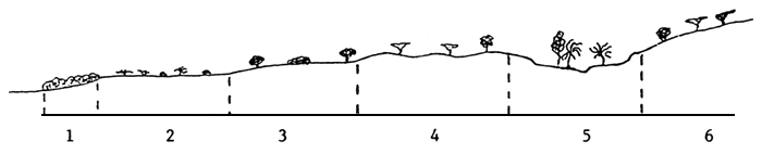
| 1: | Mangrove | |
| 2: | Saltswamp: hydromorphic saline soil (marine deposits). | |
| 3: | Slightly elevated coastal strip: marine deposits with high salinity, overlain by aeolian sand. Water table (brackish water) close to ground surface. | potential sites for dry afforestation |
| 4: | Sandy coastal plain: alluvial and fluvial deposits with medium to high salinity overlain by aeolian sand. Water table (brackish water) several metres deep. | |
| 5: | Wadi-system: fluvial deposit of medium salinity. Water table close to ground surface. | |
| 6: | Foot hills: coarse fluvial deposits of medium salinity. Water table several meters deep. |
SPECIES BY SITE MATCHING FOR DRY PLANTING OF TREES AND SHRUBS
Species combining salt tolerance, drought resistance and wind tolerance (priority species for “dry planting”)
Ranking according to tolerance to maximum electrical conductivity of soil solution (expressed in relative values termed E.C × 103)
| E.C. × 103 | Proposed sites according to site description in Figure 1 | ||||||
| Site type: | 3 | 4 | 5 | 6 | |||
| - | 50 | - | Prosopis juliflora (Kuwait land race) | X | X | X | X |
| - | 35 | - | Atriplex nummularia | X | |||
| - | Atriplex canescens | X | |||||
| - | 30 | - | Prosopis juliflora (Indian land race) | X | X | X | X |
| - | Ziziphus mauritiana (Indian provenance) | X | X | X | |||
| - | Tamarix aphylla syn T. articulata | X | X | ||||
| - | 18 | - | Parkinsonia aculeata | X | X | X | |
Ranking in alphabetical order for those species whose tolerance to maximum electrical conductivity is potentially good but needs to be further documented.
| - | Prosopis cineraria (provenance under saline conditions i.e. from Tidal or Sabka areas at Qurum and Quriat in Oman) | X | X | X | |||
| - | Prosopis juliflora (Bahrain land race) | X | X | X | X | ||
| - | Salvadora persica | X | X | X | |||
| - | Ziziphus spina-cristii | X | X | X |
Species with excellent to good resistance to drought, good to fair tolerance to salinity and good tolerance to wind (species whose capacity to withstand high salinity should be further investigated)
Ranking according to tolerance to maximum electrical conductivity of soil solution (expressed in relative values termed E.C. × 103)
| E.C. × 103 | Proposed sites according to site description in Figure 1 | |||||||
| Site type: | 3 | 4 | 5 | 6 | ||||
| - | 8.5 | - | Calligonum commosum | X | ||||
| - | 8.0 | - | Acacia tortilis (Oman provenance: Batinah coast | X | X | |||
| - | Prosopis cineraria | X | X | |||||
| at least | 7.5 | - | Moringa peregrina | X | ||||
| - | 6 | - | Balanites aegyptiaca | X | X | X | ||
| at least | 5.5 | - | Calotropis procera | X | X | |||
| at least | 3.5 | - | Acridocarpus orientalis | X | X | |||
| at least | 3.0 | - | Leptadenia pyrotechnica | X | X | |||
| 3.0 | - | Acacia tortilis | X | X | ||||
| - | Adenium obesum | X | ||||||
| 2.5 | - | Acacia mellifera | X | X | ||||
Ranking in alphabetical order for those species whose tolerance to maximum electrical conductivity is potentially good but needs to be further documented.
| - | Acacia ehrenbergiana | X | X | |||
| - | Boswellia sacra | X | X | |||
| - | Capparis decidua | X | X | X | ||
| - | Capparis spinosa | X | ||||
| - | Cordeauxia edulis | X | ||||
| - | Mimusops angel | X | ||||
| - | Ziziphus mauritania | X | X | X |
Species with excellent to good tolerance to salinity, good to fair drought resistance and good tolerance to wind (species whose capacity to withstand dry planting in the Bahrain conditions needs further investigation)
Ranking according to tolerance to maximum electrical conductivity of soil solution (expressed in relative values termed E.C. × 103)
| E.C. × 103 | Proposed sites according to site description in Figure 1 | |||||||
| Site type: | 3 | 4 | 5 | 6 | ||||
| - | 40 | - | Tamarix jordani | X | X | |||
| - | T. maris - mortui | X | X | |||||
| - | T. passerinoïdes | X | X | |||||
| - | 35 | - | Prosopis tamarugo | X | X | |||
| - | Tamarix dioica | X | X | |||||
| - | T. florida | X | X | |||||
| - | 30 | - | Casuarina equisetifolia | X | ||||
| - | Kochia indica | X | X | |||||
| - | 25 | - | Acacia ligulata | X | X | |||
| - | Tamarix nilotica | X | ||||||
| - | Ziziphus vulgaris | X | X | |||||
| - | 16 | - | Acacia farnesiana | X | X | |||
| - | A. salicina | X | X | |||||
| - | Callistemon lanceolatus | X | X | X | ||||
| - | Callistemon x “kingspark special” | X | X | X | ||||
| - | Casuarina cristata | X | ||||||
| - | Prosopis chilenis | X | X | |||||
| - | 14 | - | Acacia nilotica | X | ||||
| - | 8.5 | - | Pithecellobium dulce | X | X | |||
| - | 8.0 | - | Lawsonia inermis | X | ||||
| - | Nicotiana glauca | X | ||||||
| - | 6.0 | - | Acacia cyanophylla | |||||
| syn. A. saligna | X | X | X | |||||
Ranking in alphabetical order for those species whose tolerance to maximum electrical conductivity is potentially good but needs to be further documented.
| E.C. × 103 | Proposed sites according to site description in Figure 1 | ||||
| Site type: | 3 | 4 | 5 | 6 | |
| - Acacia ampliceps | X | X | |||
| - A. victoriae | X | X | |||
| - Conocarpus lancifolius | X | X | |||
| - Melaleuca bracteata | X | X | |||
| - M. leucadendra | X | X | |||
| - Salsola soda | X | X | X | ||
| - Sueda fruticosa | X | ||||
| - Tamarix gallica | X | X | |||
| - T. pentandra | X | X | |||
REFERENCES
BOOTH, F.E.H. and WICKENS, G.E. (1988). Non timber uses of selected arid zone trees and shrubs in Africa. FAO Conservation Guide No. 19, Rome. 176 pp.
FAO (1971). Report to the Government of Kuwait - Afforestation based on the work of R. Firmin. FAO/KU/TF 46.
KHAN, I.R. (1981). Afforestation and Agricultural Development in the Western region of Abu Dhabi (January 81); 4–11.
KHAN, I.R. (1981). Natural Vegetation of Abu Dhabi Emirate. The Pakistan Journal of Forestry (April 81): 45–50.
SHEIKH, M.I., KHAN, S.M. and KHAN, S.R. (1985). A Report on the Study Tour to United Arab Emirates. Pakistan Forest Institute, Peshawar. 41 pp.
VON MAYDELL, H.J. (1983). Arbres et arbustes du Sahel - Leurs caractéristiques et leurs utilisations. GTZ Eschborn. 531 pp.
WOOD, P.J., WILLENS, A.F. and WILLENS, G.A. (1974). An irrigated plantations project in Abu Dhabi. Commonw. For. Rev. 54.2:139–146.
1 Manuscript prepared June 1989
![]()
![]()
![]()