![]()
![]()
![]()
Appendix 1. Use of VMS in the Application of International Fisheries Agreements
Appendix 2. Inmarsat Maritime Position Report
Appendix 3. Optimised VMS Position Report Format
Appendix 4. International Standard Statistical Classification of Fishing Gear (ISSCFG)
Appendix 5. The FAO Geographical Grid
1. RELATED CONVENTIONS
1.1 The United Nations Convention on the Law of the Sea (UNCLOS)
UNCLOS is the principal body of law which governs the international use of the seas and oceans. Through UNCLOS, nations have been able to claim exclusive use of resources, including fish stocks, within an Economic Exclusion Zone (EEZ) up to 200 nautical miles from their coastal base line. MCS of EEZs is a major problem for nations as they attempt to ensure that they maintain sovereignty and derive appropriate benefits from their EEZ. For many small island nations the fish resources with their EEZs are the major source of national income. VMS has the potential to protect that income through contributing to increased effectiveness of the MCS programme.
Following the United Nations Conference on Straddling Fish Stocks and Highly Migratory Fish Stocks in 1995, an Agreement for the implementation of the provisions of UNCLOS relating to the conservation and management of straddling fish stocks and highly migratory fish stocks was opened for signature by nations. This Agreement extends UNCLOS by more specifically defining how fish stocks which straddle EEZ boundaries, or which migrate through EEZs, are to be managed with the aim of conserving those fish stocks while allowing sustainable use of them.
The Agreement (hereafter referred to as the United Nations Fish Stocks Agreement or UNA) has not yet been ratified or acceded to by the 30 nations required to give it binding legal status. However, it is important for the consideration of VMS since it clearly contains a number of provisions that are directly related to the future use of VMS.
1.1.1 Relevant Articles of the UNA
Some of the relevant articles and comments as to their relevance to VMS follow.
Article 5 General principles
In order to conserve and manage straddling fish stocks and highly migratory fish stocks, coastal States and States fishing on the high seas shall, in giving effect to their duty to cooperate in accordance with the Convention:
(j) collect and share in a timely manner, complete and accurate data concerning fishing activities on, inter alia, vessel position, catch of target and non-target species and fishing effort, as set out in Annex I, as well as information from national and international research programmes;Comment:(k) promote and conduct scientific research and develop appropriate technologies in support of fishery conservation and management; and
(l) implement and enforce conservation and management measures through effective monitoring, control and surveillance
Timely exchange of vessel position data as required by 5 (j), is an important component of an effective global VMS. Technology is clearly seen as a management tool. Nations are required to implement effective MCS and it can be argued that VMS is a primary vehicle for achieving this.Article 10 Functions of subregional and regional fisheries management organizations and arrangements
In fulfilling their obligation to cooperate through subregional or regional fisheries management organizations or arrangements, States shall:
(e) agree on standards for collection, reporting, verification and exchange of data on fisheries for the stocks;Comment:(h) establish appropriate cooperative mechanisms for effective monitoring, control, surveillance and enforcement;
While 6 (e) may primarily refer to catch data, VMS is a vehicle for the collection of that data. In addition, VMS position data provides a high degree of verification for catch data in terms of location. Again in subregional or regional organizations VMS has a role in providing effective MCS.Article 14 Collection and provision of information and cooperation in scientific research
States shall ensure that fishing vessels flying their flag provide such information as may be necessary in order to fulfil their obligations under this Agreement. To this end, States shall in accordance with Annex I.
(a) collect and exchange scientific, technical and statistical data with respect to fisheries for straddling fish stocks and highly migratory fish stocks;Comment:(b) ensure that data are collected in sufficient detail to facilitate effective stock assessment and are provided in a timely manner to fulfil the requirements of subregional or regional fisheries management organizations or arrangements; and
(c) take appropriate measures to verify the accuracy of such data.
Again, while Article 14 primarily refers to catch data, VMS is a vehicle for the collection of that data particularly in terms of timely collection and as a means of verifying catch location. In this context VMS has a quality assurance role. Further support for this occurs in Annex 1 of the agreement.Article 18 Duties of the flag State
1. A State whose vessels fish on the high seas shall take such measures as may be necessary to ensure that vessels flying its flag comply with subregional and regional conservation and management measures and that such vessels do not engage in any activity which undermines the effectiveness of such measures.
2. A State shall authorize the use of vessels flying its flag for fishing on the high seas only where it is able to exercise effectively its responsibilities in respect of such vessels under the Convention and this Agreement.
3. Measures to be taken by a State in respect of vessels flying its flag shall include:
(e) requirements for recording and timely reporting of vessel position, catch of target and non-target species, fishing effort and other relevant fisheries data in accordance with subregional, regional and global standards for the collection of such data;Comment:(g) monitoring, control and surveillance of such vessels, their fishing operations and related activities by, inter alia:
(iii) the development and implementation of vessel monitoring systems, including, as appropriate, satellite transmitter systems, in accordance with any national programmes and those which have been subregionally, regionally or globally agreed among the States concerned;
This is the strongest article in the Agreement in terms of support for the use of VMS. It explicitly requires flag States to implement VMS as a means of controlling vessels flying their flag. It also defines the nature of the VMS as being compatible with subregional, regional or globally agreed management measures among the States involved.Article 25 Forms of cooperation with developing StatesThis article presents a particularly strong case for VMS to a flag State. VMS may be the only effective means within the budget of many States of monitoring their vessels and hence of satisfying the requirements set out in paragraph 1 and 2 above. Many small and/or developing States will have vessels ranging far from their EEZ. In some cases the vessel may never come to port in the flag State. VMS will enable such States to be informed of the activities of their vessels and to inform coastal States, and subregional and regional organisations of vessel activities relevant to those coastal states or organisations in accordance with their responsibilities under other articles such as 5 (j).
VMS will not by itself enable a flag State to meet its obligations under article 18. As mentioned above, there are scenarios where a vessel does call at port in the flag State and where vessels are fishing at considerable distance from the flag State. While VMS will provide information on those vessels’ activities some other more direct investigative or enforcement action will need to be taken. Articles 19, 20, 21, 22 and 23 of the Agreement provide for a variety of compliance and enforcement measures which may be carried out on the high seas or in subregional or regional areas by both the flag State and other States.
3. Such assistance shall, inter alia, be directed specifically towards:
(c) monitoring, control, surveillance, compliance and enforcement, including training and capacity-building at the local level, development and funding of national and regional observer programmes and access to technology and equipment.Comment:
Article 24 recognises the needs of developing States in terms of the importance of fisheries to those States and their limited capacity to take disproportionate responsibility for conservation and management. Article 25 identifies forms of cooperation with the developing states. Included among the forms of cooperation is in MCS and specifically in relation to technology and equipment. VMS is an area where technological assistance and equipment provision can usefully be supplied for the benefit of the developing States.
STANDARD REQUIREMENTS FOR THE COLLECTION AND SHARING OF DATA
Article 1 General Principles
The timely collection, compilation and analysis of data are fundamental to the effective conservation and management of straddling fish stocks and highly migratory fish stocks.... All data should be verified to ensure accuracy. ....
Article 2 Principles of data collection, compilation and exchange
(b) States should ensure that fishery data are verified through an appropriate systemComment:(c) States should compile fishery-related and other supporting scientific data and provide them in an agreed format and timely manner to the relevant subregional or regional fisheries management organization or arrangement where one exists. Otherwise, States should cooperate to exchange data either directly or through such other cooperative mechanisms as may be agreed among them;
VMS is a vehicle for the collection of fishery data particularly in terms of timely collection and as a means of verifying catch location. In this context VMS has a quality assurance role.Article 5 Reporting
A State shall ensure that vessels flying its flag send to its national fisheries administration and, where agreed, to the relevant subregional or regional fisheries management organization or arrangement, logbook data on catch and effort, including data on fishing operations on the high seas, at sufficiently frequent intervals to meet national requirements and regional and international obligations. Such data shall be transmitted, where necessary, by radio, telex, facsimile or satellite transmission or by other means.
Comment:
Satellite transmission from vessels such as is available via a VMS is specifically recognised as a vehicle for the collection of fishing data.Article 6 (Data verification)
States or, as appropriate, subregional or regional fisheries management organizations or arrangements should establish mechanisms for verifying fishery data, such as:
(a) position verification through vessel monitoring systems;Comment:
The role of VMS as a means of assuring data quality is specifically recognised.1.1.2 Consequences of the UNA
While the UNA has not yet attained binding status it does provide an insight into the future of VMS on a global basis. UNCLOS and the UNA provide a strong basis for cooperation in fisheries management and conservation via subregional and regional management arrangements. The UNA provides obligations in relation to such management arrangements where VMS plays a significant role. The UNA, either directly or through implication, identifies a role for VMS in MCS and as a means of assuring the quality of catch and effort data. VMS in conjunction with the UNA’s compliance and enforcement measures, may represent the only cost effective means of flag States meeting their obligations in ensuring that their vessels do not contravene subregional and regional conservation and management measures.
The UNA foreshadows the use of compatible VMS and the exchange of data between flag States and coastal States or subregional or regional management organisations. There are already examples of how this may work in practice. In the European Union, member States have agreed to implement a national VMS in each state and apply the VMS to most vessels over 24 metres in length. Vessels are to report positions to both flag and coastal States although it not clear how this is to be achieved.
In the Pacific, a subregional organisation, the South Pacific Forum has commenced development of a VMS through its Forum Fisheries Agency (FFA). The small developing island member States will be served by a distributed VMS. Vessels operating in the EEZs of all member States will report to a centralised VMS hub from which appropriate position reports and incident alerts will be sent to relevant national monitoring centres. The VMS hub will automatically notify the national monitoring centre of the appropriate coastal State when a vessel moves into that State’s EEZ from an adjoining member State’s EEZ.
The Commission for the Conservation of Antarctic Marine Living Resources (CCAMLR) has called for the voluntary use of VMS by member states as a trial for assessing the effectiveness of monitoring vessel activities in the geographically remote Antarctic area. The USA, South Africa, New Zealand and Australia have agreed to monitor vessels of their flag fishing in the CCAMLR area during the 1997 fishing year. A significant issue in this trial will be the ability of the flag states to effectively control their vessels at such remote localities.
Further similar developments to those planned in the European Union, the FFA and CCAMLR are envisaged as subregional and regional organisations develop their fisheries management arrangements and the UNA comes into force.
1.2 FAO Compliance Agreement
The Agreement to Promote Compliance with International Conservation and Management Measures by Fishing Vessels on the High Seas (the FAO Compliance Agreement) is an agreement within the framework of the Food and Agriculture Organisation of the United Nations (FAO) and is an integral part of the International Code of Conduct for Responsible Fisheries.
The FAO Compliance Agreement does not specifically refer to VMS but does contain some requirements which are relevant.
1.2.1 Relevant Articles of the FAO Compliance Agreement
Article III FLAG STATE RESPONSIBILITY
(a) Each Party shall take such measures as may be necessary to ensure that fishing vessels entitled to fly its flag do not engage in any activity that undermines the effectiveness of international conservation and management measures.
3. No Party shall authorize any fishing vessel entitled to fly its flag to be used for fishing on the high seas unless the Party is satisfied that it is able, taking into account the links that exist between it and the fishing vessel concerned, to exercise effectively its responsibilities under this Agreement in respect of that fishing vessel.
7. Each Party shall ensure that each fishing vessel entitled to fly its flag shall provide it with such information on its operations as may be necessary to enable the Party to fulfil its obligations under this Agreement, including in particular information pertaining to the area of its fishing operations and to its catches and landings.
Comment:
Similar to the UNA, the FAO Compliance Agreement requires flag states to exercise responsibility for the activities of their fishing vessels. This extends, in paragraph 3, to a requirement to provide information on vessel operations, particularly relating to where a vessel conducts fishing operations. VMS is arguably the most reliable method of providing the required vessel operation information and enabling the flag state to effectively exercise any control over the vessel.Article V INTERNATIONAL COOPERATION
1. The Parties shall cooperate as appropriate in the implementation of this Agreement, and shall, in particular, exchange information, including evidentiary material, relating to activities of fishing vessels in order to assist the flag State in identifying those fishing vessels flying its flag reported to have engaged in activities undermining international conservation and management measures, so as to fulfil its obligations under Article III.
Comment:
This section requires parties to the agreement to exchange information, particularly evidentiary material relating to the activities of fishing vessels. VMS information is undoubtedly evidentiary material relating to the activities of fishing vessels. For example, it could identify a vessel which may be fishing in a particular EEZ or high seas fishing zone.1.2.2 Consequences of the FAO Compliance AgreementWhile the text of this paragraph makes exchange of information a requirement in relation to vessels which have been suspected of, or “reported” to be engaged in activities undermining management measures, exchange of VMS information to establish the suspicion would still seem to be a reasonable obligation under this paragraph in view of the overall intention of the FAO Compliance Agreement in preventing activities which undermine conservation and management measures.
The FAO Compliance Agreement has similar implications for the use of VMS as the UNA. VMS would enable parties to the agreement to meet their obligations as a flag state in monitoring the activities of their vessels on the high seas and exchanging VMS information with coastal states, subregional or regional organisations to establish a breach of conservation and management measures. Again similar to the UNA, there are other requirements in the FAO Compliance Agreement which suggest cooperation between flag and port states to effectively take compliance action against vessels.
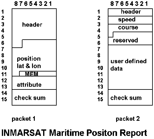
The Inmarsat Maritime position report uses bit mapping to make optimal use of space within the format of its 15 byte data report packets. Because provision is made for a micro encoded message and its variable (attribute) in the first packet, the addition of speed and course requires a second packet.
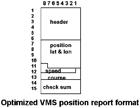
By removing the micro encoded message from the Inmarsat maritime position report, it is possible to include all of the necessary elements for a complete position report, including speed and course, in a single, 15 byte packet.
|
Gear Categories |
Standard Abbreviations |
|
|
SURROUNDING NETS |
|
|
|
|
With purse lines |
PS |
|
|
- one boat operated purse seines |
PS1 |
|
|
- two boat operated purse seines |
PS2 |
|
|
Without purse seines |
LA |
|
SEINE NETS |
|
|
|
|
Beach Seines |
SB |
|
|
- boat or vessel seines |
SV |
|
|
- Danish seines |
SDN |
|
|
- Scottish seines |
SSC |
|
|
- pair seines |
SPR |
|
|
Seine nets (not specified) |
SX |
|
TRAWLS |
|
|
|
|
Bottom trawls |
|
|
|
- beam trawls |
TBB |
|
|
- otter trawls1 |
OTB |
|
|
- pair trawls |
PTB |
|
|
- nephrops trawls |
TBN |
|
|
- shrimp trawls |
TBS |
|
|
- bottom trawls (not specified) |
TB |
|
Midwater trawls |
|
|
|
|
- otter trawls1 |
OTM |
|
|
- pair trawls |
PTM |
|
|
- shrimp trawls |
TMS |
|
|
- Midwater trawls (not specified) |
TM |
|
|
Otter twin trawls |
OTT |
|
|
Otter trawls (not specified) |
OT |
|
|
Pair trawls (not specified) |
PT |
|
|
Other trawls |
TX |
1 Fisheries agencies indicate side and stern bottom, and side and stern and stern midwater trawls as OTB-1 and OTB-2 and OTM-1 and OTM-2, respectively.
|
Gear Categories |
Standard Abbreviations |
|
|
DREDGES |
|
|
|
|
Boat dredges |
DRB |
|
|
Hand dredges |
DRH |
|
LIFT NETS |
|
|
|
|
Portable lift nets |
LNP |
|
|
Boat-operated lift nets |
LNB |
|
|
Shore-operated lift nets |
LNS |
|
|
Lift nets (not specified) |
LN |
|
FALLING GEAR |
|
|
|
|
Cast nets |
FCN |
|
|
Falling Gear (not specified) |
FG |
|
GILLNETS AND ENTANGLING NETS |
|
|
|
|
Set gillnets (anchored) |
GNS |
|
|
Driftnets |
GND |
|
|
Encircling gillnets |
GNC |
|
|
Fixed gillnets (on stakes) |
GNF |
|
|
Trammel nets |
GTR |
|
|
Combined gillnets-trammel nets |
GTN |
|
|
Gillnets and entangling nets |
GEN |
|
|
Gillnets (not specified) |
GN |
|
TRAPS |
|
|
|
|
Stationary uncovered pound nets |
FPN |
|
|
Pots |
FPO |
|
|
Fyke nets |
FYK |
|
|
Stow nets |
FSN |
|
|
Barriers, fences, weirs etc. |
FWR |
|
|
Aerial Traps |
FAR |
|
|
Traps (not specified) |
FIX |
|
HOOKS AND LINES |
|
|
|
|
Handlines and pole-lines (hand operated)1
|
LHP |
|
|
Handlines and pole-lines (mechanised)1 |
LHM |
|
|
Set longlines |
LLS |
|
|
Drifting longlines |
LLD |
|
|
Longlines (not specified) |
LL |
1 Including jigging lines
|
Gear Categories |
Standard Abbreviations |
|
|
|
Trolling lines |
LTL |
|
|
Hooks and lines (not specified)1 |
LX |
|
GRAPPLING AND WOUNDING |
|
|
|
|
Harpoons |
HAR |
|
HARVESTING MACHINES |
|
|
|
|
Pumps |
HMP |
|
|
Mechanised dredges |
HMD |
|
|
Harvesting machines (not specified) |
HMX |
|
MISCELLANEOUS GEAR2 |
MIS |
|
|
RECREATIONAL FISHING GEAR |
RG |
|
|
GEAR NOT KNOWN OR SPECIFIED |
NK |
|
1 Code LDV for dory operated line gear will be maintained for historical purposes.2 This item includes: hand and landing nets, drive in nets, gathering by hand with simple hand implements with or without diving equipment, poisons and explosives, trained animals, electrical fishing.
The FAO geographical grid is a global standard for position reporting commonly used by distant water tuna vessels. It can, however, be used to report the fishing grounds in which any vessel is operating. The grid is based upon the format SQTTGGG where:
![]()
![]()
![]()