![]()
![]()
![]()
Floodplains do not exist in isolation, but as part of a much larger river system. The potential yield of a floodplain fishery depends on environmental factors both in its local floodplain area and throughout its whole river catchment. High productivity requires plentiful supplies of unpolluted water and nutrients from upstream, and the regular inundation of the floodplain. Locally important factors include the size of the floodplain area and the seasonal changes in water levels and dissolved oxygen. The variety and importance of such factors is particularly notable in floodplain habitats, in which the most extreme conditions occur as a regular part of each flood cycle. In addition to this high natural variability, the floodplain environment is also particularly vulnerable to modification by mankind's attempts at river control and development. In this section, the variety and variability of the floodplain environment is demonstrated for the project study sites, to show their importance for the management of floodplain fisheries.
Floodplain rivers comprise a wide range of different habitat types, from the pools and riffles of the small upland streams, down through the smooth glides of the middle sections, and eventually to the broad, meandering rivers, floodplains and ox-bow lakes of the lowland sections. Such ‘longitudinal’ zonation is widely described in textbooks about river systems (see e.g. Welcomme, 1985, and Cowx and Welcomme, 1998).
Within the lowland floodplain sections, habitats may be divided into areas of flowing water in river channels and areas of virtually still water over flooded grassland and forest, and in semi-permanent depressions and permanent lakes. Floodplain rivers may be either meandering or braided in form. The different types of channels are often fringed by raised embankments or levees formed naturally by the deposition of suspended sediment, carried down from eroding areas upstream. The relative proportions of the different areas varies widely both within and between catchments and over the progression of the flood cycle.
In addition to the wide diversity of natural habitats, a range of new habitats may be created by man's impact on the floodplain system. At the R5953 PIRDP study site in Bangladesh (see below), the floodplain is subdivided artificially by a flood control embankment and by many roads and footpaths. All the larger roads have canals alongside them, produced by the excavation of the earth used to raise the road above water level. The Bangladesh floodplain is nearly all converted to agricultural use, including both wet and dry land rice and other cash crops. The natural floodplain waterbodies are also supplemented by many smaller fish pits dug by fishermen, and by household ponds. In contrast, the River Lempuing study site in Indonesia is mostly still in its natural condition without roads or canals: transport around the Lempuing is still mainly by motorboat or canoe, even in the dry season. While the Lempuing has both savanna grassland floodplains and flooded forests, the latter forested floodplains have now almost disappeared from the Bangladeshi river catchments, due to human overexploitation. These various types of natural and man-made floodplain habitats are listed in Table 2.1.
Table 2.1 Habitat types found at the Bangladesh and Indonesia study sites
| Habitat type | Bangladesh | Indonesia | |
| Floodplains | Savanna grassland floodplain | Lebak | |
| Forested floodplain | Rawang | ||
| Agricultural floodplain | Floodplain | Sawah | |
| Rivers | Main river and secondary channels | River | Sungei |
| Canal | Khal | ||
| Lakes | Larger permanent lakes | Haor/Baor | Danau |
| Natural floodplain depressions | Beel | Lebung | |
| Excavated fish pits | Kua | ||
| Household ponds | Mathel |
The principal driving force responsible for the productivity of fish and other major biota in river-floodplain systems is the seasonal pulsing of river flows or ‘flood pulse’ which produces periodic inundations of the floodplain. The bulk of this production is derived directly or indirectly within the floodplain itself, supported by the additional inputs of inorganic nutrients brought in from the main river channel during the pulse. These promote primary production from phytoplankton, grasses and higher plants. In addition, the movement of the littoral zone of the flood waters across the floodplain promotes the decomposition of organic material and the release of nutrients (Junk et al., 1989).
The rapid increase in primary production and area available for colonisation by aquatic organisms following floodplain inundation supports a diverse community of highly productive fauna. Fish exploit this surge of production, by feeding on the abundant food resources to grow rapidly during the flood season. The floodplain also provides sheltered spawning grounds with plenty of refuges in amongst the submerged vegetation for the young and juvenile stages. Pools, lakes, and river channels, replenished with water by the flood pulse, also provide dry season refuges for floodplain-resident species of fish (Welcomme, 1985).
The highly seasonal and unpredictable nature of the floodplain environment naturally selects for species with very high rates of reproduction, growth, early maturity and high fecundity. Fish production and resilience to exploitation is generally higher on the floodplain than within more stable environments (Lowe-McConnell, 1987). The floodplain environment also promotes species diversity due to its dynamic habitat structure (Junk et al, 1989).
By contrast primary and secondary production in the main channel is relatively low. The shifting sandy substrate, high depth, turbidity, turbulence and strong currents make the main channel unfavourable for primary production. Siltation, swift currents and absence of aquatic vegetation also make the beds of most large rivers unsuitable for benthic organisms and few higher animals have adapted to utilise this habitat exclusively. Those that do tend to be predators of fish or aquatic invertebrates which depend to a great extent directly or indirectly upon the primary production upon the floodplains (Junk et al, 1989). Therefore, although the main rivers do support large fisheries, the highest yields are associated with the floodplain habitat. The main channel is used mainly as a migration route for gaining access to feeding and spawning grounds upon the floodplain or as a refuge during the dry season.
Since the majority of fish production is dependent upon the flood pulse, any activities of other users within the wider river catchment which can affect the timing, extent and duration of the flood pulse or the quality of its water have the potential to significantly impact fish production within the river system (see section 3.4).
With their many different habitat types, floodplain systems are spatially complex environments. Two key features provide the best places for fishing: the channels which drain the floodplain and the residual dry-season waterbodies. Floodplain fish become highly concentrated in these habitats during their emigration from the floodplain and then later in the dry-season. These locations are usually well known to local fishers and in high demand for access to fishing rights. These locations also provide the key to managing the fishery, by avoiding excessive exploitation at these highly vulnerable times. The importance of these habitats to fishing communities and their close knowledge of the different local habitats make it essential to include fishing communities in the management of floodplain rivers.
The spatial and environmental characteristics of a selection of the DFID study sites are illustrated in the following sections.
Hail Haor study site, NE Bangladesh (Project R4791)
The Hail Haor study site in NE Bangladesh (Figure 2.1) is a natural shallow depression of around 150km2 surrounded on the west, south and east by low hills used for agriculture, particularly as tea plantations. The lake is fed by over 300 small streams draining the adjacent land, but particularly by the Lungla river flowing from higher ground to the south. Water is constrained within the system both by a man-made bottleneck to the north and by the back pressure of water flooding the larger Kushiara and Manu rivers beyond. In the rainy season, Hail Haor floods to the very edges of the many settlements scattered around its perimeter to become a substantial, open lake around 3–4m deep in the middle and up to 5m over the submerged river channels. During the subsequent dry season, the water evaporates or drains away through the northern outflow to leave a diverse system of dry season water bodies. Permanent water includes the small Gopla river and a 10–20km2 area of open water around 0.5–1m deep in the middle of the haor. Surrounding these waters, the semi-permanent floodplain rises fairly sharply to the west and more gradually to the east. The eastern plain in particular thus has a variable relief and is dotted with many channels and ponds which become cut off from the main lake as the water falls. Fish may either be trapped in these ponds, or beels, or emigrate back to the flowing water of the Gopla river. Hail Haor may thus be considered as a discrete, basin-shaped lake with many inflows, one main outflow and a dry season habitat split between the central river and many isolated pools beyond.
PIRDP study site, NW Bangladesh (Project R5953)
The hydrologically modified study site of the ‘Fisheries Dynamics’ project was located at the confluence of the Padma (Ganges) and Jamuna (Brahmaputra) rivers, in NW Bangladesh (Figure 2.2). At this position, 150km inland from the coast, with a floodplain altitude of around 25ft (7.6m), the Padma and Jamuna have vast widths of up to 2 and 7km respectively. Alongside these major rivers are the Badai and Atrai secondary rivers, and their floodplains and lakes, lying inside and outside the Pabna Irrigation and Rural Development Project (PIRDP, see Section 2.3.2). These secondary rivers and their floodplains lie in between the two main rivers and have comparable sizes (20–50m river widths) to the Indonesian River Lempuing. Virtually all of the land illustrated in the lower map in Figure 2.2 becomes flooded during the high water season. The PIRDP floodplains are much flatter than the basin-shaped Hail Haor site, and water is distributed through a complex network of river channels and in both small and large beels and other lakes.
Farming is the primary occupation within the PIRDP floodplains, but fishing is an important source of income for many people. Due to the relative flatness of the site, fishing/agricultural villages are widely scattered across all parts of the floodplain lands (Figure 2.2).
The Indonesian study sites (Projects R4791 and R5953)
The majority of the Indonesian studies have been undertaken at the River Lempuing site (Case study site 1 in Figure 2.3). The River Lempuing has one of the most productive inland fisheries in Indonesia, and has been the subject of a number of earlier studies (eg. Vaas, Sachlan and Wirwatmadja, 1953; Giesen and Sokotjo, 1991). The Lempuing brings rainwater from the high ground of Sumatra's Barisan mountain range to the west, and joins the Ogan, Komering and Musi rivers downstream of the study site. This middle region of these major rivers is a complex of lateral fringing floodplains, known locally as lebak-lebung. With pronounced local variations in relief, the flood lands are divided into many discrete water bodies with large areas of temporarily flooded lebak and both permanent and semi-permanent lakes or lebung. These habitats are flooded by both local rainfall and, more importantly, by overspill from the main rivers through breaks in the river levees. On slightly higher ground, between the lebak plains and the higher ground, are areas of rawang swamp forest, which may also have permanent water. In the dry season, the stronger riverine flows of the Lempuing river maintain a depth of around 2–4m in most stretches with scoured pools up to 8m deep. In the rainy season, the river rises up to 4m and the lebaks flood to a depth of around 1m. The lebung pools vary both in depth and area from shallow depressions which evaporate completely in the dry season, to lakes retaining up to 4km2 of open water. As indicated in Figure 2.3, the Lempuing has only temporary fishing settlements within the floodplain area: these are inhabited for one or more years at a time by those fishers who win access rights by bidding in an annual auction. Most of the fishers originate from the permanent, district (kecamatan) town of Pedamaran.
The other Indonesian case study sites in Sekayu and Jambi districts (Figure 2.3, ‘Case study sites 2–5’) were investigated as a comparisons with the River Lempuing lake district. These locations have smaller floodplain systems, with few major lakes, but located alsongside larger main rivers. These floodplains are also more associated with permanent fishing villages, allowing more active local participation in the management of the fisheries (see Section 5.1.3).
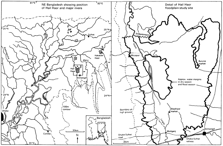
Figure 2.1 Map of the Hail Haor study site in NE Bangladesh (Project R4791; from MRAG, 1994)
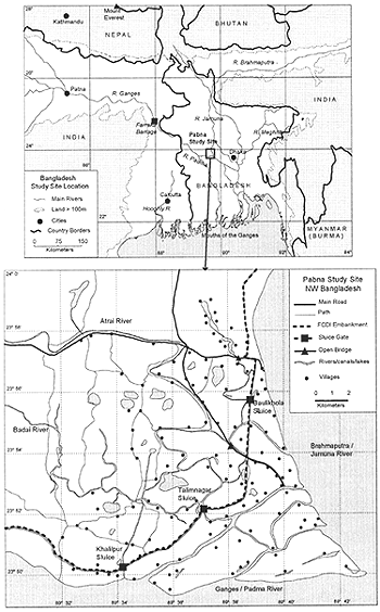
Figure 2.2 Map of the PIRDP study site in NW Bangladesh (Project R5953; from Halls et al, in press (b))
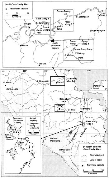
Figure 2.3 Map of the River Lempuing and Jambi study sites in Sumatra, Indonesia (Projects R4791 and R5953; from Hoggarth et al, in press (a))
A good understanding of local dry season waterbodies is critical to the successful management of floodplain fisheries. During the dry season, water levels fall to leave the main river channel and a number of other pools, ponds and lakes. These waterbodies may or may not remain connected to the river. In those waterbodies which become disconnected, water quality deteriorates swiftly as the dry season progresses. Many fish species - known as ‘whitefish’ (see Section 3.2) - find it difficult to survive the low oxygen levels found in such waterbodies and try to return to the main river during the drawdown. Other fish - known as ‘blackfish’ - are adapted to survive the dry season conditions by having air-breathing capabilities or being able to tolerate the low oxygen levels.
During the drawdown and dry seasons, both fishing and natural mortality rates reach a peak. Fish are highly concentrated at such times and relatively easy to capture by fish drives, de-watering or other methods (see Sections 4.1 and 4.2). Even blackfish may be unable to survive if waterbodies dry up completely, though some blackfish can burrow into the mud to survive until the next rains. To ensure the productivity of the blackfish stocks in the next flood year, it is essential to ensure that some fish are able to survive in these dry season waterbodies. As described in Part 1, effective measures may include reserves, gear bans and seasonal closures, or appropriate combinations of these tools.
This section reports an investigation made at the PIRDP study site to determine the relative amounts of different types of dry season waterbodies, and their ability to retain water for the full length of the dry season (see Hoggarth et al, in press (b)). Such information indicates which waterbodies blackfish may survive in during the dry season, and therefore where reserves may be most effectively placed to ensure the survival of fish stocks.
The numbers of dry season waterbodies was determined from group interviews with communities and households at a randomly selected 20 villages at the study site (10 inside and 10 outside the PIRDP). The initial interviews distinguished 5 different types of dry season waterbodies:
| Beels | Permanently flooded lakes, usually too large to de-water |
| Rivers | Permanently flooded rivers/canals, usually too large to de-water |
| River Kuas | Deep sections in rivers/canals, which may be fished by de-watering |
| Floodplain Kuas | Floodplain depressions/ponds, which may be fished by de-watering |
| Household Kuas | Household ‘mathel’ ponds, created during the excavation of earth to raise the land height for house-building, and fishable by de-watering. |
All of the floodplain kua, river kua and household kua waterbodies were reportedly created or deepened by excavation, to produce fish pits of sufficient depth to attract fish as the dry season approached. River sections were usually not excavated, though some waters, especially those close to the sluice gates, were deepened or maintained through excavation. In contrast, none of the beel waters were excavated.
In both the ‘inside’ and ‘outside’ study regions at the PIRDP, the perennial beels and river sections were the largest in size, usually several hectares (Table 2.2). The floodplain and river kuas, fishable by de-watering, were smaller, usually less than one hectare; and the household kuas were generally very small, with average dimensions of only around 12.5 by 6 metres. Numbers of waterbodies, however, followed the opposite trend, with very few beels and river sections, hundreds of floodplain and river kuas and thousands of household kuas within the 109km2 study site. In terms of their total dry season areas, the household kuas covered the largest areas: 3.3 to 6.1% of the total high water flooded areas (Table 2.2). The beels and river sections also covered reasonably large areas of the floodplain (0.15 to 1.17%), while the kua pits within rivers only comprised 0.01–0.02%. Comparing across the PIRDP embankment, the inside region had a greater area of beel, floodplain and river kua waters, while the outside region had more river waters and household kuas. The five waterbody types were, however, all well represented in both regions.
Most beel and river waterbodies in both the inside and outside regions were found to be permanent, i.e. they retained water for the full year (Table 2.2). In contrast, and reflecting their relative sizes, up to 50% of floodplain and river kuas retained some water through the whole dry season, while only 13–15% of the small household kuas did not dry out. Minimum water depths and dates of desiccation followed the same trends, with beels and rivers retaining 0.5–2.4m of water, floodplain and river kuas retaining only 0.7–1.0m of water or drying out by March, and household kuas mostly drying out by January (Table 2.2).
In conclusion, it is clear that the main habitats in which blackfish may survive over the dry season are in the larger, permanent beel waterbodies and river sections. Though household ponds in Bangladesh contribute much the greatest total area of dry season waterbodies, very few of these retain water for the full dry season. Reserves intended as dry season survival habitats should clearly be placed in the larger, deeper and most permanent waterbodies, as may be identified by local fishers.
Table 2.2 Relative sizes and water retention of five categories of dry season waterbodies, inside and outside the PIRDP flood control, drainage and irrigation scheme, NW Bangladesh (after Hoggarth et al, in press (b))
| Waterbody Types | Inside PIRDP | Outside PIRDP | |
| Beels | |||
| Size (ha, mean and range) | 52.5ha, 5–100 | 14.6ha, 3–30 | |
| % of total high water flooded area | 2.64% | 1.30% | |
| % of waterbodies retaining water | 50% (2 of 4) | 100% (6 of 6) | |
| Minimum dry season depth (m, mean and range) | 0.5, - | 1.6, 0.5–3.0 | |
| Average date of desiccation (mean and range) | 15/3, - | - | |
| Rivers | |||
| % of total high water flooded area | 0.44% | 1.17% | |
| % of waterbodies retaining water | 100% (12 of 12 sections) | 100% (7 of 7) | |
| Minimum dry season depth (m, mean and range) | 1.3, 0.8–3.0 | 2.4, 0.3–5.0 | |
| Average date of desiccation (mean and range) | - | - | |
| Floodplain Kuas | |||
| Size (m2, mean and range) | 1033 m2, 60–7200 | 190 m2, 48–1500 | |
| % of total high water flooded area | 0.44% | 0.15% | |
| % of waterbodies retaining water | 50% (39 of 78) | 15% (15 of 102) | |
| Minimum dry season depth (m, mean and range) | 0.7, 0.3–1.5 | 0.7, 0.3–2.0 | |
| Average date of desiccation (mean and range) | 30/3, 1/2–1/6 | 11/3, 15/10-1/6 | |
| River Kuas | |||
| Size (m2, mean and range) | 391 m2, 25–2400 | 279 m2, 25–1500 | |
| % of total high water flooded area | 0.02% | 0.01% | |
| % of waterbodies retaining water | 29% (14 of 49) | 4% (1 of 26) | |
| Minimum dry season depth (m, mean and range) | 1.0, 0.3–2.5 | 1.0, - | |
| Average date of desiccation (mean and range) | 28/3, 1/2-15/6 | 11/5, 1/1–1/6 | |
| Household Kuas | |||
| Size (m2, mean and range) | 97 m2, 6–500 | 84 m2, 15–400 | |
| % of total high water flooded area | 3.30% | 6.07% | |
| % of waterbodies retaining water | 15% (9 of 61) | 13% (15 of 119) | |
| Minimum dry season depth (m, mean and range) | 0.4, 0.3–0.5 | 0.6, 0.3–1.0 | |
| Average date of desiccation (mean and range) | 29/1, 1/11–15/4 | 10/1, 15/10–15/4 | |
NB: Minimum depths calculated on only those waterbodies which retained some water
Average desiccation dates calculated on only those waterbodies which dried out
Floodplains are highly seasonal environments, with annual cycles of flooding, drainage and drought. The relative magnitude and timing of these hydrological events change significantly both between localities and between different years, and the productivity of the floodplain depends largely on these cycles. Large floods generate large fish stocks due to the extensive opportunities for feeding and growth, while long or very dry droughts may increase the effectiveness of the dry season fishing gears and produce larger catches. This section briefly describes the flood seasonality at the study sites, to illustrate the high variability in these events.
In Bangladesh, the rainy season is associated with the SW monsoon which generally arrives in May. Water levels rise rapidly to a maximum in June and may then stay at a similarly high level for up to 5 months, until September or October. In contrast, the Indonesian and Thai study sites of project R4791, being located on eastern coasts, receive most of their rainfall during the subsequent NE monsoon. For both sites, this occurs around six months later, with peak rainfall in November, and water levels rising to a maximum around December (see Figure 2.4 for the River Lempuing). Apart from these timing differences, the Indonesian flood regime then follows that of Bangladesh with water levels staying high for around 5 months until April on average). In Thailand, however, a large proportion of the annual precipitation falls on only a few days (CORIN, 1991) leading to rapid increases in water levels. Such floods are then relatively short lived as there is little to obstruct the flow of water to the sea nearby. Compared to the other sites, then, the Songkla basin is seen to have the most extreme flooding regime, with problems of excess rainfall in a very short wet season but no sustained period of high water. Since the inundated plains provide the main feeding opportunities for fish, the shorter flood season in Thailand may be expected to reduce fish productivity at this site.
Both high water and low water heights can vary significantly between years. At the well-drained, riverine Indonesian site, dry season heights in particular vary widely between years: 1976 and 1982 were especially dry years with extended periods of very low water levels (Figure 2.4 and Figure 2.5). This affects the success of dry season fishing in the different years, with fishers often relying strongly on good dry season catches to maintain their annual incomes. In years such as 1980 or 1991, many fishers would have been unable to achieve good catches.
In addition to the year-to-year changes, high water flood levels on the River Lempuing also show a declining long-term trend over the 18 years since 1975 (Figure 2.5, regression slopes significant at P = 0.04 and P = 0.06 for maximum and average flood heights respectively). A significant decline may be expected to reduce the productivity of the fishery and should be investigated by catchment managers. Declines in mean flood levels may be due to excessive water abstraction, e.g. for agricultural irrigation in upstream parts of the catchment.
In Bangladesh, the high water levels are particularly variable between years, due to changes in the amount of rain falling in the upper catchment areas of the Padma and Jamuna Rivers. Occasionally, the peak flows of both the Padma and the Jamuna rivers occur at the same time, causing ‘extreme’ or ‘catastrophic’ flooding (Figure 2.6). Many authors including Matin and Husain, (1989), Ahmad (1989), and Pramanik (1994) have blamed deforestation within Bangladesh and its neighbouring countries for higher discharge rates and increased silt loading leading to shallower rivers. These two factors combine to make the rivers more prone to flooding.
Extreme floods disrupt transport and communication systems and damage infrastructure such as roads, railways, bridges, embankments and buildings. In the most severe cases, many lives are lost and people are left homeless. For example, in the catastrophic flood of 1988, 30 million people were made homeless: between 1960 and 1980, approximately 800,000 lives are thought to have been lost (Temple and Payne, 1995). Given that much of Bangladesh's population live at agrarian subsistence level, damage to crops caused by extreme flooding presents a serious threat to the welfare of the people and to the economy as a whole. Rice, jute, sugarcane and vegetable crops are all susceptible to damage caused by flooding. Furthermore, the very unpredictability of extreme floods may have an indirect negative effect on crop production as farmers appear unwilling to risk investing resources in an attempt to increase yield. Drinking water supplies can also become contaminated during extreme floods, which are invariably followed by diseases such as cholera, diarrhoea and dysentery. As described in the following section, low lying countries such as Bangladesh have increasingly attempted to avoid these dangers by modifying floodplain rivers to control flood patterns.
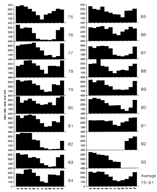
Figure 2.4 Time series of the monthly mean water levels at the Lubuk Lampam CRIFI field station gauge on the Lempuing River (Project R4791, gauge broken from January to September, 1992; from MRAG, 1994)
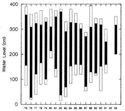
Figure 2.5 Maximum and minimum mean monthly water levels (open bars) and average flood season (January–April) and dry season (July–September) water levels (black bars) on the Lempuing River in years 1975 to 1993 (Project R4791, data not available for 1992 and dry season 1993, from Hoggarth and Utomo, 1994)
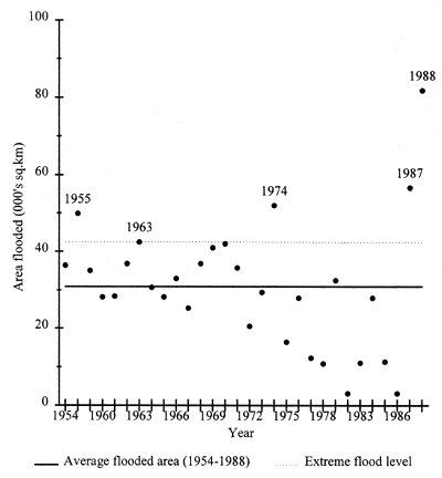
Figure 2.6 Area inundated by flooding in Bangladesh, 1954–1988 (from Halls, 1998, redrawn from Ahmad, 1989)
In their natural state the lowest reaches of rivers consist of two major components: the river channel and the floodplain. Each of these is made up of a complex of habitats whose diversity supports exceptionally rich fish faunas. The main river channel is usually broken down into a hierarchy of channels interspersed with islands. The channels themselves meander through the landscape with a regular sequence of deeps and shallows, point bars and dead arms. The floodplains are interspersed with deep and shallow lakes normally showing a succession from newly formed, deep water bodies that are still connected to the main flux every year, to ancient, shallow and marshy areas isolated from the river itself. Natural river functioning depends on the diversity in form of these various habitats and the inter-connectivity between them, with uninterrupted flows along the main channels and the seasonal invasion of the plain and its waterbodies.
Changes to the main channel
Changes to the main channel are produced for a variety of reasons including impoundment of water for power generation, irrigation or flood control, deepening of the channel for navigation and to accelerate the evacuation of flood waters from the land. The overall result is to reduce channel diversity through the elimination of meanders, the straightening of the channel and the raising and revetting of the channel banks. Connectivity is suppressed along the main channel as dams block migratory pathways and alter the hydrological cycle. The floodplain is progressively disconnected from the river by suppressing the flood or containing it within the main channel.
Changes to the floodplain
The floodplain tends to become increasingly isolated from the main channel of the river in the interests of human occupation and of agriculture. This is achieved by isolating the plain from the river by a series of longitudinal river levees, by enclosing areas of the floodplain in dykes to produce polders and the creation of networks of canals associated with pumping to remove all water from the enclosed perimeters. The result of these interventions is to fill floodplain lakes and to transform the mosaic of aquatic environments into a uniform agricultural landscape.
General impacts
These modifications to the river system act together on the complex of habitat types in such a way as to simplify the system, break down longitudinal and lateral inter-connectivity, and isolate the floodplain. Such interventions can be challenged on several grounds. Firstly they reduce the productivity of the fishery and may produce drastic changes in the composition of the fish fauna. Former resident species may disappear and introduced species, better adapted to the new conditions, may rise to prominence (see Welcomme, 1985 for details on the mechanisms by which hydraulic works impact river fish communities). Secondly, maintaining the system in its altered state is extremely costly. This cost is compounded by the increased human occupation of areas that have been modified and are perceived as safe for habitation. Thirdly, recent catastrophic flooding in areas so controlled demonstrates the high risks of such interventions.
To illustrate the detailed effects of floodplain modification, the following sections describe the impacts of the PIRDP flood control scheme on flood patterns and agriculture at the Bangladesh R5953 study site.
The Pabna Irrigation and Rural Development Project was constructed during the early 1970s to protect Pabna communities from extreme flooding and provide controlled irrigation for agriculture. A total area of 1,845km2 is now protected from the flood waters of the Padma and Jamuna rivers by an embankment of over 200km in length (Figure 2.7). A smaller area of 219km2, in the north east corner of the scheme, is supplied with irrigation water from a pumping station at Bera (Figure 2.7). Water levels inside the PIRDP are controlled by the Bera pump and a second pump at Koitola, and by the opening of 15 sluice gates spaced at intervals around the embankment.
The 219km2 irrigation area lies adjacent and to the north of the R5953 project study site (compare Figure 2.7 with Figure 2.2). The SE corner of the PIRDP, which overlaps with the study site, is not specifically targeted for controlled irrigation, and the River Atrai sluice gates to the north are often kept closed to keep water within the irrigation area. Though it is not irrigated, the study site is completely protected from the main river floods by the embankment.
Water inside the PIRDP is supplied mainly by local rainfall, supplemented by water pumped in by the Bera station, or allowed to drain in through the sluice gates. The pumping stations and sluice gates are managed to produce a moderate and controlled flood for the high water aman rice production without threatening local communities, and to provide further irrigation water during the dry season.
Operation of the PIRDP sluice gates
The PIRDP's 15 perimeter sluice gates vary in size from 3 to 15 vents, with each vent having an aperture of between 1.5×1.8m and 6.1×2.6m. The sluice gates are generally closed during the rainy season due to the dangers of excessive overspill from the main rivers, and then opened at the end of the high water season, to allow the floodplain waters to drain to the main river. The PIRDP sluice gates may therefore be used to prolong the aman rice season to ensure a successful crop.
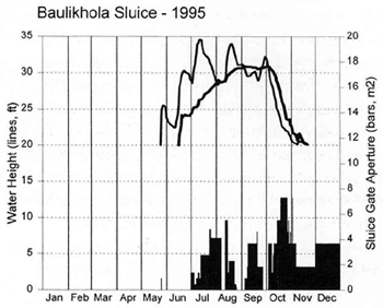
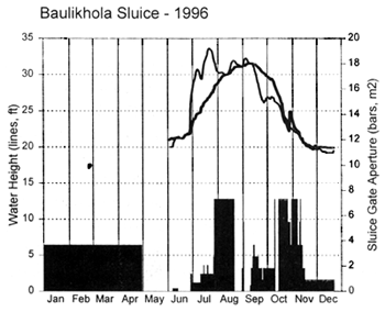
The project study site in the south east corner of the PIRDP is drained by the main Talimnagar sluice gate on the Badai river, and also by two smaller gates, one at Baulikhola, 8km northwards along the embankment, and the other at Khalipur, 6km to the south west (Figure 2.2). The six-gate Talimnagar sluice, on the Badai river within the project study site (Figure 2.2 and Figure 2.7), has the largest maximum aperture of all the PIRDP gates, at 94.6m2. Water levels were monitored by project R5953 both inside and outside the Talimnagar and Baulikhola sluice gates on a daily basis throughout both 1995 and '96. Sluice gate apertures were also recorded every day at both sites to observe the detailed management of water resources in this vicinity.
The following sections describe the detailed operation of the sluice gates in 1995 and '96, and their contribution to the PIRDP water levels.
Sluice gate operations in 1995
In 1995, both sluice gates were kept closed at the beginning of the flood season during both May and June. At this time the PIRDP experienced much local rainfall and the inside water levels rose at a rate where any extra floodwater from outside could have pushed water levels dangerously high. The flood pulses flowing down the Jamuna and Padma in these months were thus largely excluded from the PIRDP by the closed gates (Figure 2.8). Water levels reached the outside floodplains (altitudes around 25ft) in mid June, but did not inundate the inside floodplains until early July.
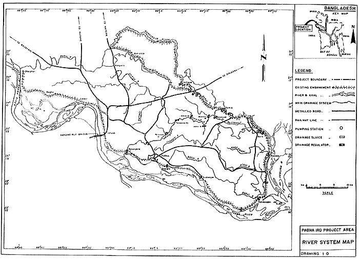
Figure 2.7 Map of the Pabna Irrigation and Rural Development Project (PIRDP) in NW Bangladesh (from SWMC, 1994). The R5953 study site straddled the embankment in the SE of the PIRDP (compare with Figure 2.2).
From July 1995 onwards, the two gates were operated quite differently (Figure 2.8). As water levels continued to rise to their maximum levels outside, water was only allowed into the PIRDP through the Talimnagar gate for four days in mid-July and three days in mid-August. Apart from these times, the sluice gate was only opened when the inside water heights either equalled or exceeded the outside heights. The gate was thus first opened to a large aperture in early August, when the water levels were equal inside and out. Local staff report that the gate was opened at this time following requests from fishermen to encourage fish migration into the PIRDP. The Talimnagar gate was then mostly closed again when outside water levels rose in August and again in late September. The sluice gate was finally fully opened in early October when outside water levels began to fall, and both inside and outside water levels dropped at a similar rate due to the large aperture of the gate.
In contrast, the Baulikhola gate was opened far more often over the 1995 flood season, particularly during the July and August late flood pulses. Local staff reported that the Baulikhola gate was less rigorously controlled by the Bangladesh Water Development Board (WDB) than the Talimnagar gate (where the WDB gate officer resided). Local fishermen were then able to open the Baulikhola gate themselves during these periods to allow fish inside the PIRDP waters.
Sluice gate operations in 1996
In 1996, the two sluice gates were managed in more similar ways, suggesting that both gates were more tightly controlled by the Talimnagar WDB officer. The 1996 flood started early but then rose very slowly so that mid-June water heights were around 10ft lower than in 1995 (Figure 2.8). Due to the low local rainfall levels, the Talimnagar sluice was opened in early May and both gates were opened from mid-June onwards in an attempt to inundate the floodplains within the PIRDP. Even with the gates opened this way, the 1996 floodplain inundation was still some two weeks later than in 1995 (Figure 2.8). Like 1995, however, the gates were still only partially opened during most of July, until the main flood pulse had passed and water levels began to fall. The gates were then opened to their maximum extent, as requested by fishermen when in/out water levels became equal in August. Having achieved an inside flood of some 31–32ft above mean sea level by mid August, the sluice gates were then closed again until mid September, when outside water levels began to fall. At that time the sluice gates were again opened only partially to allow the water out gradually and prolong the aman growth season inside the PIRDP. As in 1995, the gates were fully opened again half way through October to allow the floodplains to drain.
PIRDP impact on water levels
The overall effect of the PIRDP flood control structures is to delay and smoothen the flood curve inside the scheme compared to that outside (Figure 2.8). The high flood levels up to almost 35ft recorded outside the sluice gates, produced by flood pulses of the Jamuna / Padma rivers, are thus avoided inside, where water levels rose and fell more gradually up to a maximum of only 31.5ft. Such conditions enable the maximum high water aman rice production as the crop has time to grow with the gently rising water levels, without being suddenly submerged.
The PIRDP also reduces the duration of the flood season compared to that outside (Table 2.3). Due to their relative sizes, the Baulikhola sluice drains its vicinity more slowly than the Talimnagar one, and the inside flood is slightly longer at the former site. Overall, the inside floods were 10 days shorter at Baulikhola and 20–25 days shorter at Talimnagar (Table 2.3). Combining the water heights and flood duration as a ‘flood index’ (foot-days of inundation over the average floodplain depth of 25ft), the inside flood magnitude was substantially reduced in both years, at both sites. In 1995, inside flood indices were 68% of outside ones at Baulikhola, and 66% at Talimnagar. In 1996, the inside flood rose to a higher level than in 1995, and inside flood indices were a higher 81% and 75% of those outside (Table 2.3).
 |  |
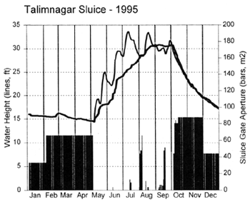 | 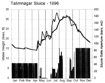 |
Figure 2.8 Daily water heights measured inside (thick lines) and outside (thin lines) the PIRDP Talimnagar and Baulikhola sluice gates, and daily sluice gate apertures in 1995 and '96 (from Hoggarth et al, in press (b)).
Table 2.3 Comparative flood indices inside and outside the PIRDP's Talimnagar and Baulikhola sluice gates in 1995 and 1996 (from MRAG, 1997).
| Sluice Gate | Baulikhola | Talimnagar | |||
| Position | Inside | Outside | Inside | Outside | |
| Year: 1995 | |||||
| Flood Index (foot-days inundated) | 454 | 667 | 420 | 632 | |
| Maximum Floodplain Depth (ft) | 5.9 | 9.6 | 5.8 | 8.6 | |
| Days Floodplain Inundated | 111 | 121 | 109 | 129 | |
| Year: 1996 | |||||
| Flood Index (foot-days inundated) | 435 | 535 | 398 | 532 | |
| Maximum Floodplain Depth (ft) | 6.5 | 8.6 | 6.4 | 8.3 | |
| Days Floodplain Inundated | 97 | 107 | 90 | 115 | |
PIRDP Benefits to agriculture
The traditional crop in the Pabna deepwater floodplain regions is broadcast, long-stem aman rice, planted at the start of the flood and harvested during the drawdown, as the floodplains become accessible again. The more controlled flooding resulting from the PIRDP irrigation is designed to allow high-yielding varieties (HYVs) of rice to be produced year round over three crop seasons. In the 1st ‘carif’ season, from March to June (dry/early flood season), aus rice (e.g. IRRI II variety) is planted. In the 2nd high water carif, July to October, the traditional aman rice is still grown. Finally, over the dry or ‘ribbi’ season, IRRI short stem rice, along with jute, wheat, mustard and other vegetables are all now grown successfully. Before the PIRDP, mainly only the high water Aman rice was grown at a cropping intensity of 118%1. Cropping intensities inside the PIRDP are now reported to be 190% in some flood cells, approaching the final target figure for production of 212% overall (E. Rahman, Pabna WDB Executive Engineer, pers. com., 1994).
According to local farmers, dry season production in the SE study site corner of the PIRDP (i.e. outside the NE irrigation sector), is similar inside and outside the embankment. However, while inside production is relatively reliable, the outside crops - particularly the main aman rice crop-may occasionally be completely destroyed when the unregulated floods rise dramatically and submerge the crops. Total annual crop production inside the PIRDP is thus generally at least double that outside.
PIRDP Impacts on fish production
As described above, the PIRDP embankment controls and reduces flooding inside this scheme, with corresponding benefits for the agricultural sector. The impacts of the PIRDP on fish productivity and production are reported in Section 3.4, while the potential management approaches for such a modified fishery are described in Section 5.4.
1 Cropping intensities over 100% indicate some land producing more than one crop per year
![]()
![]()
![]()