![]()
![]()
![]()
Land degradation has been defined as the set of processes that lower the current and potential capability of the land to produce (quantitatively or qualitatively) goods and services. Degradation processes cause a decrease in the quality of land. For the purposes of this methodological development, and for the sake of comparing current land use with potential land use involved in LUCs, two concepts in land degradation are useful:present land degradation, and the risk of land degradation. The former is assessed for current or actual land-use patterns, while the latter can only be predicted as risk incurred if potential scenarios of land use were implemented.
The methods to assess present land degradation depend on the type of land degradation: physical, chemical or biological. The assessment of land degradation necessitates the assessment of each of the component processes. This section concentrates on the methodological details of land degradation assessment. The approaches to land degradation range from simple qualitative observations in the field to elaborate computer simulation modelling of complex processes. Table 14 summarizes the approaches.
| Direct field observations using diagnostic criteria or simple visual indices (subjective) Landscape units assessment (land systems and facets) and subjective rating Parametric semi-quantitative method (computation of indices on factors) Rating system and decision trees (computer automation) Simulation modelling (computer modelling) |
Parametric semi-quantitative approach
A parametric semi-quantitative approach to the assessment of land degradation was adopted. The rationale for this:
it is a relatively fast and inexpensive method and less involved than either setting up medium to long-term field experimental plots or calibrating and running datademanding and expertise-based computer simulation models of degrading processes.
the main aim of the assessment was to obtain a picture of the current “status” of degradation of the land in a rapid, low-cost and useful manner with little demand for either specific expertise in modelling or processes, or very specific data.
The fundamental premise of the approach is that land degradation (D) is a function of: “climate aggressivity” (C), soil resistance to that aggressivity (S), topographic factors (T), natural vegetation (V), land use (L), and land management (M). Thus, for current or actual land use, D = f (C, S, T, V, L, M).
For operating conditions of implementing a given LUC, V, L and M would remain constant, which would be the case of a given PLUT.
Land degradation can be estimated as a function of four factors:
climate,
soil,
topography,
a human factor, which expresses itself directly as the choice of land cover and its management.
These four factors can be readily observed in any field situation and become the main groups of data for the assessment. The diagnostic parameters or indicators to observe, calculate or measure for each factor of a given process and type of degradation are indicated in Tables 15, 16 and 17.
| Process | Factors | |||
| Climate | Soils | Topography | Human factor | |
| Soil erosion by water | Erosivity of rainfall (R)
| K erodibility factor(USLE) from Weichmeir’s nomographs or from textural classes and parent material | Slope (S) and slope length (L) factors (USLE) | Crop (C) and |
| Soil erosion by wind | Wind erosivity index:
| CEC or pF15 | N.A. | Coefficient of natural vegetation per LUT |
| Compaction, crusting, sealing | Erosivity of rainfall (R)
| Crusting index: | Flat lands are more susceptible | Heavy machinery, no cover crops, puddling |
| Process | Factors | |||
| Climate | Soils | Topography | Human factor | |
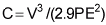
| Salinization | P/PET < 1 and salt in the landscape | P/PET < 0.75 and presence of some saline soils in the area | Assessed by landform: closed basin, lacustrine beds | No levelling of irrigated land, excess irrigation, quality of groundwater |
| Sodication | P/PET < 1, but with higher values for Sodication | P/PET < 0.75 and presence of some saline soils in the area | Assessed by landform: closed basin, lacustrine beds | No levelling of irrigated land, excess irrigation, quality of groundwater |
| Acidification |
| Low CEC and presence of kaolinitic clay | Flat lands are more vulnerable | Deforestation increases leaching, excess fertilizers, excess irrigation |
| Toxic comps. | P/PET < 1, dry climate | Preponderant geologic material with substance as part of composition | Low, flat and depositional | Proximity to factories & mines, irrigation with sewer water, excess of pesticides and chemicals |
| Process | Factors | |||
| Climate | Soils | Topography | Human factor | |
| Decline in SOM | K2 = 1/2Se0.1065t (P/PET) | Texture: sandy > clay | N.A. | Land cover and shade affect soil temperature C/N ratio of crops in the LUT Additions of organic matter If OM decreases and SOM is mineralized more slowly than it is added, then there is biological degradation |
A comparison between the compound index for actual land degradation (D) for a given tract of land and the land degradation risk estimated by such parameters for each PLUT (Drisk) will indicate whether the rates of degradation would increase or decrease with the potential LUC. Thus: change in land degradation rate = (Drisk - D).
The type of degradation affecting the land and the factors responsible for such degradation under the actual or any potential land use will also be clear from these systematic observations.
Land degradation assessment and databases
The parameters in Tables 15, 16 and 17 are indicators of degradation processes in the three types of land degradation. They are not direct assessments themselves. However, being indicators or “proxy” variables, they are included in most databases on climate and land resources. The following list comprises the minimum data sets that need to be assembled in order to calculate such degradation indices:
· Climate:
- mean monthly precipitation (p),
- annual precipitation (P),
- effective precipitation (Thornthwaite) (PE),
- potential evapotranspiration (PET) estimated with current methods (e.g. Penman, Penman-Monteith, Thornthwaite),
- wind velocity (average) (V),
- rainfall erosivity (factor “R” from the universal Soil Loss Equation (USLE)), estimated as a function of its intensity from nomographs (Wischmeier and Smith, 1965; FAO, 1978a),
- mean monthly temperature (t).
· Soil/landscape:
- soil erodibility (factor “K” from the USLE), estimated as a function of other soil parameters (texture, organic matter, depth, etc.) from nomographs (Wischmeier and Smith, 1965; FAO, 1978a),
- cation exchange capacity (CEC) of the soil (weighted average over the soil depth considered),
- soil moisture constant (pF = moisture content in the soil at 15 bars of tension),
- fine silt content in the soil (Zf) in percent (2-20 mm),
- coarse silt content in the soil (Zc) in percent (20-50 mm),
- clay content of the soil (A percent) in percent, and clay type (e.g. kaolinitic),
- organic matter (OM percent) content in the soil, in percent,
- humus content of the soil (B) in equilibrium (percent),
- calcium carbonate (CaCO3) in the soil, in percent (C),
- slope (S) in percent (percent),
- slope length (L) in metres,
- landform (descriptive).
· Management and human factors:
- crop factor (factor “C” from USLE tables; Wischmeier and Smith, 1965; FAO, 1978a),
- soil conservation practices (factor “P” from USLE tables; Wischmeier and Smith, 1965; FAO, 1978a),
- land cover (percent of area covered and percent of shade, types of crops and vegetation,
- annual additions of DPMs including crop residues and manures (tonnes/ha/year),
- land use (description in terms of LUTs).
The variables in the minimum data set can be obtained readily. Common sources of these types of data are:
soil survey reports,
soil databases,
meteorological databases,
land use/land cover maps and reports.
Soil, land resources, meteorological and land use or land cover databases are common sources of digital data for compiling the variables of the minimum data sets to calculate the indices of the three types of land degradation.
Field surveys for land degradation assessment
In order to produce estimates of the indices or indicators of the three types of land degradation, computed at specific sites, it is necessary to obtain the input variables for the calculation at such sites, as part of the minimum data sets. For the purpose of data gathering, a set of quadrat sampling sites of 10 × 10 m was defined. These quadrat sites were the same sites as the ones used for the biomass and plant diversity estimations.
The quadrat sites are located using a stratified random sampling scheme, where the strata correspond to land cover classes derived from a satellite image interpretation or from air-photo interpretation. The number of samples in each class is a compromise between maximizing data collection for representation, and time, effort and cost.
The data collection takes place through gathering data from existing databases (i.e. climate, soil and land use and management) before the start of the field survey and complementing, confirming and validating these data with field observations and measurements where necessary. Field forms were used to gather necessary information on the three types of land degradation.
Data gathering and the completion of the land degradation field forms were performed simultaneously as the biomass and biodiversity measurements were completed in the field. This requires a multidisciplinary field team and the division of tasks while in the field in order to achieve efficiency. The technical aspects regarding the sampling scheme and distribution of samples in the studied area are dealt with above in the sections on biomass and biodiversity estimation.
The field data gathering is followed by a data processing phase where data are input into digital spreadsheets. The calculations are then made in order to yield the indices for each process and type of land degradation.
Data processing for land degradation assessment
Field data were collected for assessing: erosion by water and wind; degradation by compaction and crusting; and chemical degradation including observations on acidification, salinity, sodication and toxicity, as well as information on biological degradation. Observations were made on climate, soil state, microtopography, macrotopography, vegetation cover and human impacts (positive and negative).
Data compilation
The data collected on the forms were compiled into spreadsheet format where data from climate stations (i.e. temperature, precipitation and potential evapotranspiration) and detailed soils data could be added. Using these data, the processes affecting land degradation could be modelled. Tables18-24 illustrate the details of data compiled from each fieldform.
Data modelling and calculation of degradation status and risk
Based on the data provided at each quadrat site, indices for each of the modes of degradation were calculated. The results were assessed according to FAO (1979) methodology. Table 25 outlines the basic elements needed in order to assess land degradation.
With the relevant information and data sets compiled and organized, the calculations of each of the indicator variables per each of the types of land degradation were set up and performed in spreadsheets. According to the values calculated per each of the indicator variables or indices, a rating system was set up according to FAO (1979) procedures for each type of land degradation. The ratings were derived depending on the ranges of values of each of the indicator variables of the type of land degradation evaluated. Tables 26-29 show the rating systems for four of the types of degradation processes (i.e. erosion by water, wind, biological degradation, and compaction and crusting) that were used in the case studies accompanying this report.
Using these rating systems and classes, examples of these types of the indicator or index measures were rated with respect to the different factors affecting land degradation. The climate, soil, topography and human influence ratings were then multiplied together to assess the current state and risk of each type of degradation. Tables 30 and 31 present examples of the calculations. The case studies provide full examples of data and calculations.
TABLE 18 - General information to be collected from the study area for land degradation assessment (e.g.Texcoco watershed, Mexico)
| Site | Geographical given | Terrenos planos suceptibles | Evaluada por geoforma: cuenca cerrada planicie de inundación | Plana y deposicional | Cambio en la CIC ó PF15 | Baja CIC y presencia de arcilla Kaolinitica | Material geologico: con materiales toxicos abundantes | ||
| Lat. N(19°) | Long. W(98°) | Topografia | |||||||
| 01 - 01 | 30.331' | 54.698' | Plana | Plano vegetación gramineas | Planicie suceptible a inundación, alta sodicidad | Plana | Solonchak contiene sodio Pss>15 percent | Solonchak | Rocas igneas, contaminación por basura, radioactivos y materiales pesados |
| 01 - 02 | 30.418' | 54.438' | * | * | * | * | * | * | *** |
| 01 - 03 | 30.354' | 55.650' | Plana | * | Zona de depositación | Plana | Vertisol haplico | Baja, mediana | Rocas igneas, sedimentarias |
| 02 - 01 | 30.113' | 56.613' | Plana | Plana, alfalfa | Planicie suceptible a inundación, alta sodicidad | Plana | Eutric planosol | Planosol | *** |
| 02 - 02 | 30.860' | 56.758' | Plana | * | Planicie | * | Solonchak | Baja | Rocas igneas, sedimentarias |
| 03 - 01 | 29.985' | 53.418' | * | * | * | * | * | * | *** |
| 04 - 01 x | 27.671' | 48.800' | Lomerio abrupto | Pendiente concava, posible acumulación en microcuencas | Lomerio abrupto | No afecta | * | Baja CIC suelos de ando | No |
| 05 - 01 | 30.355' | 50.914' | Plana | * | Planicie ligera inundación, cuenca abierta | Plana | Entisol | Mediana | Rocas igneas, fertilizantes y pesticidas |
| 07 - 01 | 29.800' | 51.367' | * | * | * | * | * | * | *** |
| 07 - 02 | 30.628' | 53.402' | * | * | * | * | * | * | *** |
| 07 - 03 | 29.972' | 52.352' | Plana | * | Planicie, zona de depositación | Plana | Entisol | Alta | Rocas igneas, fertilizantes y pesticidas |
| 08 - 01 | 26.906' | 46.272' | Lomerio suave | Si es suceptible | Lomerio suave | * | * | * | Igneo |
| 08 - 02 | 26.694' | 46.218' | Lomerio suave | No por ser lomerio | Lomerio suave | * | * | * | Igneo no materiales toxico |
| 08 - 03 | 29.800' | 31.387' | * | Minima | * | * | * | * | *** |
| 08 - 04 (a) | 30.152' | 58.475' | Plana | Terrenos ligeramente plano | Planicie de inundación, a cuenca abierta | Plana | Entisol cantidad moderata de limo | Presencia de arcilla Kaolinita | Rocas igneas, fertilizantes y pesticidas |
| 08 - 04 (b) | 29.942' | 49.972' | Plana | * | Cuenca abierta suceptible a lavado | Plana | Entisol regosol | Mediana | Rocas igneas, fertilizantes y pesticidas |
| 08 - 04 (c) | 29.170' | 50.580' | * | * | * | * | * | * | *** |
| 08 - 05 | 30.610' | 51.343' | Plana | * | Planicie cuenca abierta | Plana | Entisol | Mediana | Rocas igneas, fertilizantes y pesticidas |
| 12 - 01 | 26.324' | 44.933' | Lomerio aprubto | No son terrenos planos | Serrania (lomerio-abrupto) | No es plana | * | * | Igneo no materiales toxico |
| 12 - 02 | 26.790' | 45.495' | * | Acumulación de M.O. y residuos organicos | No | No | * | Andosol muy arcilloso | Presencia de Al, Fe y Mn (suelos de andosol) |
| 12 - 03 | 25.353' | 44.813' | * | No influye (cañada) | Parte baja acumulación de agua y sales | No | * | Andosol arcilloso | Presencia de Al, Fe y Mn |
| Strat/ plot_ID | SOILS | TOPOGRAPHY | COVER | CONSERVATION | |||||||||
| Soil group | % silt | % clay | % sand | % OM | Soil structure | Permeability | Slope (%) | Slope < | Slope length (m) | % cover | Type of cover | Contouring/contour stripcropping/terracing | |
| 01 - 01 | Vc + Vp/3 (89) | 48 | 20 | 32 | 0.6 | 1 | 5 | 0.5 | 0.225 | 200 | 100.00 | maize | |
| 01 - 02 | | | | | | | | | | | | | |
| 01 - 03 | Zg + Vc - n/3 | | | | | | | 1 | 0.45 | 500 | 100.00 | pasture | |
| | | | | | | | | | | | | | |
| 02 - 01 | Zg + Vc - n/3 | 44 | 22 | 34 | 1.1 | 1 | 5 | 0.5 | 0.225 | 200 | 95.00 | fallow | |
| | | | | | | | | | | | | | "blind basin??" terraces and"coverturas" with measures of conservation |
| 04 - 01 | | | | | | | | 14 | 6.3 | 50 | 80.00 | young forest | Reforestation ~ 10-year old trees |
| 05 - 01 | Hh/2 | | | | | | | 3 | 1.35 | 100 | 40.00 | maize, oats | |
| 07 - 03 | Hh/2 | | | | | | | 2 | 0.9 | 200 | 95.00 | maize | |
| | | | | | | | | | | | | legume residue | |
| 08 - 01 | | | | | | | | 5 | 2.25 | 50 | 70.00 | (husks/pods) | |
| 08 - 02 | | | | | | | | 4 | 1.8 | 100 | 100.00 | maize | |
| 08 - 04 (a) | Hh/2 | | | | | | | 5 | 2.25 | 1 000 | 60.00 | maize | linear furrows, divided plots |
| 08 - 04 (b) | Vp/3 | | | | | | | 2 | 0.9 | 100 | 35.00 | maize | furrowed |
| 08 - 04 (c) | Hh + Be/2 | | | | | | | | 0 | | 100.00 | (crops) | |
| 08 - 04 (d) | Hh/2 | | | | | | | | 0 | | 100.00 | (crops) | |
| 08 - 05 | Vp/3 | | | | | | | 2 | 0.9 | 200 | 80.00 | maize | |
| 12 - 01 | Bh + Tm/1 | | | | | | | 80 | 36 | 20 | 100.00 | forested | |
| 12 - 02 | Bh + Tm/1 | | | | | | | | 0 | | 100.00 | forested | resid treebits |
| 12 - 03 | Be + I + Bh/2 | | | | | | | | 0 | | 100.00 | forested | resid treebits |
| 12 -04 | | | | | | | | | 0 | | 100.00 | forested | |
| X | Y | Site | Elev | R | K | LS | C | P | AGIS |
| 508840.2 | 2156664 | 01-01 | 2242.66 | 2118.96 | 0.04 | 0.00 | 0.19 | 1.00 | 0.00 |
| 509722.2 | 2156881 | 01-02 | 2242.06 | 2120.96 | 0.04 | 0.00 | 0.19 | 1.00 | 0.00 |
| 507755.8 | 2156519 | 01-03 | 2243.40 | 2116.88 | 0.04 | 0.00 | 0.19 | 1.00 | 0.00 |
| 515057.4 | 2156765 | 05-01 | 2282.99 | 2159.53 | 0.02 | 1.20 | 0.19 | 1.00 | 9.80 |
| 515245.4 | 2155449 | 07-01 | 2321.82 | 2180.96 | 0.02 | 1.30 | 0.19 | 0.55 | 5.90 |
| 510951.2 | 2156476 | 07-02 | 2240.20 | 2125.70 | 0.04 | 0.00 | 0.19 | 1.00 | 0.00 |
| 512425.9 | 2155767 | 07-03 | 2248.17 | 2136.10 | 0.00 | 0.00 | | | |
| 524094.1 | 2150128 | 08-01 | 2969.23 | 1745.54 | 0.02 | 3.90 | 0.09 | 1.00 | 12.30 |
| 523674.8 | 2150273 | 08-02 | 2944.00 | 1751.19 | 0.02 | 3.50 | 0.19 | 1.00 | 23.30 |
| 516272 | 2156158 | 08-03 | 2320.00 | 2189.05 | 0.02 | 2.30 | 0.19 | 0.55 | 10.50 |
| 516431 | 2154538 | 08-04a | 2366.99 | 2144.70 | 0.02 | 1.00 | 0.19 | 0.55 | 4.50 |
| 516431 | 2156967 | 08-04b | 2309.80 | 2173.06 | 0.02 | 1.90 | 0.19 | 0.55 | 8.60 |
| Strat/ plot_ID | CLIMATE | SOILS | Class | ||||||
| Rainfall erosivity factor (R) | 1.- Crusting index | (Zf + Zc)/Zc | 2.- CI = (1.5 × Zf + | % | % | Zf | Zc | ||
| 01 - 01 | 2118.962 | Classification(?) | 36 | 1.938169985 | 1.841 | 33.830 | 35.000 | 65.000 | SOFT CRUSTING |
| 01 - 02 | 2120.956 | | 51 | 1.769814052 | 2.488 | 38.686 | 50.000 | 50.000 | SOFT CRUSTING |
| 01 - 03 | 2116.884 | | 51 | 1.769814052 | 2.488 | 38.686 | 50.000 | 50.000 | SOFT CRUSTING |
| 02 - 01 | | | 51 | 1.769814052 | 2.488 | 38.686 | 50.000 | 50.000 | SOFT CRUSTING |
| 02 - 02 | | | 51 | 1.769814052 | 2.488 | 38.686 | 50.000 | 50.000 | SOFT CRUSTING |
| 03 - 01 | 2129.104 | | 36 | 2.978817299 | 1.045 | 23.540 | 35.000 | 65.000 | INTENSE CRUSTING |
| 04 - 01 | | | 36 | 3.354870775 | 1.190 | 18.280 | 35.000 | 65.000 | INTENSE CRUSTING |
| 05 - 01 | 2159.528 | | 36 | 3.354870775 | 1.190 | 18.280 | 35.000 | 65.000 | INTENSE CRUSTING |
| 07 - 01 | 2180.962 | | 36 | 3.354870775 | 1.190 | 18.280 | 35.000 | 65.000 | INTENSE CRUSTING |
| 07 - 02 | 2125.7 | | 36 | 2.978817299 | 1.045 | 23.540 | 35.000 | 65.000 | INTENSE CRUSTING |
| 07 - 03 | 2136.104 | | 36 | 3.354870775 | 1.190 | 18.280 | 35.000 | 65.000 | INTENSE CRUSTING |
| 08 - 01 | 1745.541 | | 36 | 2.308481532 | 1.221 | 31.650 | 35.000 | 65.000 | INTENSE CRUSTING |
| 08 - 02 | 1751.186 | | 36 | 2.308481532 | 1.221 | 31.650 | 35.000 | 65.000 | INTENSE CRUSTING |
| 08 - 03 | 2189.053 | | 36 | 3.354870775 | 1.190 | 18.280 | 35.000 | 65.000 | INTENSE CRUSTING |
| 08 - 04 (a) | 2144.704 | | 36 | 3.354870775 | 1.190 | 18.280 | 35.000 | 65.000 | INTENSE CRUSTING |
| 08 - 04 (b) | 2173.057 | | 36 | 2.978817299 | 1.045 | 23.540 | 35.000 | 65.000 | INTENSE CRUSTING |
| Strat/ plot_ID | CLIMATE | | | SOILS | TOPOGRAPHY | HUMAN FACTOR | Comments |
| P/PET < 1 | Evidence of salts on surface | Value Na | P/PET < 0.75 | Geoform evaluation: closed watershed, flooded plains and infiltration. | Excessive irrigation, deficient infiltration and water quality | ||
| 01 - 01 | 0.476269421 | 1 | 488.625 | 0.724498614 | susceptible to flooding | temporal and irrigated | |
| 01 - 02 | 0.476269421 | 1 | 1265.231 | 0.724498614 | flat | temporal and irrigated/drainage | |
| 01 - 03 | 0.476269421 | 1 | 1265.231 | 0.724498614 | susceptible to flooding | temporal and irrigated | |
| 02 - 01 | 0.476269421 | 1 | 1265.231 | 0.724498614 | abrupt hills | na | |
| 02 - 02 | 0.476269421 | 1 | 1265.231 | 0.724498614 | open watershed | temporal/conventional usage | Conventional use |
| 03 - 01 | 0.449495774 | | 45.500 | 0.449495774 | flat, depositional | temporal | Conventional use |
| 04 - 01 | 0.487430529 | 0 | 82.000 | 0.487430529 | open watershed, susceptible to flooding | temporal (natural) | |
| 05 - 01 | 0.487430529 | + | 82.000 | 0.487430529 | open watershed, susceptible to erosion | temporal (natural) - excessive erosion during rain events | |
| 07 - 01 | 0.449495774 | - | 82.000 | 0.449495774 | | | |
| 07 - 02 | 0.487430529 | | 45.500 | 0.487430529 | | | |
| 07 - 03 | 0.487430529 | + | 82.000 | 0.487430529 | flat, open watershed | temporal/conventional usage | |
| 08 - 01 | 0.487430529 | + | 65.000 | 0.487430529 | mountainous / abruptly hilly | temporal | |
| 08 - 02 | 0.487430529 | + | 65.000 | 0.487430529 | no | no | |
| 08 - 03 | 0.487430529 | - | 82.000 | 0.487430529 | flooded hollow | no | |
| Strat/ plot_ID | CLIMATE | SOILS | TOPOGRAPHY | HUMAN FACTOR | Comments | |
| P/PET < 1 | Dry climate | Geological material with large amounts of toxic materials. | Flat and depositional | Irrigation with sewage, close to mines | ||
| 01 - 01 | 0.476269421 | yes | igneous rock, contamination heavy metals | flat | excessive pesticides, high salinity, sodicity fertilizers | high salinity, sodium, fertilizers |
| 01 - 02 | 0.476269421 | yes | | | | |
| 01 - 03 | 0.476269421 | yes | igneous rock, sedimentary | flat | heavy metals | |
| 02 - 01 | 0.476269421 | yes | igneous rock, slightly saline, | flat | pesticides, fertilizers, moderate salinity, irrigated, dispersed waste, | |
| 02 - 02 | 0.476269421 | yes | igneous rock, sedimentary | flat | heavy metals/household and industrial chemicals | |
| 05 - 01 | 0.487430529 | yes | igneous | flat | fertilizers/pesticides/powerlines | powerlines/rainfed agri |
| 07 - 03 | 0.487430529 | yes | igneous | flat | fertilizers/pesticides | maiz bien desunolado(?) |
| 08 - 01 | 0.487430529 | yes | igneous | yes | surrounded by canal, trail | surrounded by canal, trail |
| 08 - 02 | 0.487430529 | yes | igneous, not toxic | gently rolling hills | truck, near a canal of "agua blanco" | |
| 08 - 04 (a) | 0.449495774 | yes | igneous rock | flat | gravel pit, 500 m away, pesticides, fertilizers | |
| 14 - 03 | 0.487430529 | yes | derived from limestone | | no | |
| 14 - A - 01 | 0.487430529 | yes | igneous rocks | no | fertilizers N | fertilized with N |
| 14 - A - 02 | 0.487430529 | yes | igneous rocks | no | fertilizers | fertilized/chemicals |
| 14 - A - 03 | 0.487430529 | yes | igneous rocks | no | fertilizers/leaching | washed ("lavado") |
| 14 - B - 03 | 0.487430529 | yes | igneous rocks | no | fertilizers/insecticides/leaching | washed |
| 18 - 01 | 0.487430529 | yes | presence of aluminium (Andosols) Fe Mn | no | no | |
| Strat/ plot_ID | CLIMATE | SOILS | B = m (K1/K2) | TOPOGRAPHY | HUMAN FACTOR | Comments | ||||||||
| PP | PET | Clay | CaCO3 | K2 = 1/2Se0.1065t(P/ETP) | | K1 = Humidification Coefficient | K2 = 1 200/(A +200) (C + 200) | Not applicable | Cover and shade affect the soil temperature | Incorporation of organic matter | C/N relation of the LUT | |||
| 01 - 02 | 643.7 | 1391.6 | 38.686 | 5.938 | 15.81940012 | Very severe | 43600 | 1035.358 | 42.111 | * | 100 | residual of OM - pasture/sewage | | |
| 01 - 03 | 643.7 | 1391.6 | 38.686 | 5.938 | 15.81940012 | Very severe | 43600 | 1035.358 | 42.111 | | 100 | little OM | | |
| 02 - 01 | 572.328 | 1257 | 38.686 | 5.938 | 15.81940012 | Very severe | 43600 | 1035.358 | 42.111 | | | | | wood extraction |
| 02 - 02 | 572.328 | 1257 | 38.686 | 5.938 | 15.81940012 | Very severe | 43600 | 1035.358 | 42.111 | | 40 | residual of OM"deshierbes | | |
| 03 - 01 | 572.328 | 1257 | 23.540 | 0.930 | 14.18620651 | Very severe | 43600 | 1078.625749 | 40.421 | | 95 | residual of OM of desierbes, branches on tree | | |
| 04 - 01 x | 597.042 | 1257 | 18.280 | 0.079 | 16.72634125 | Very severe | 43600 | 1099.939527 | 39.638 | | | | C>N | |
| 05 - 01 | 643.7 | 1391.6 | 18.280 | 0.079 | 16.72634125 | Very severe | 43600 | 1099.939527 | 39.638 | | small amount of cover | none/little incorp. of OM | >N for fertilization | |
| 07 - 01 | 571.538 | 1516 | 18.280 | 0.079 | 14.18620651 | Very severe | 43600 | 1099.939527 | 39.638 | | 60 | residual of OM of "deshierbe", few branches on trees | | |
| 07 - 02 | 571.538 | 1516 | 23.540 | 0.930 | 16.72634125 | Very severe | 43600 | 1078.625749 | 40.42180527 | | 35 | residual of OM of deshierbe | C/N relation small | |
| 07 - 03 | 571.538 | 1516 | 18.280 | 0.790 | 16.72634125 | Very severe | 43600 | 1103.848268 | 39.49818218 | | | | | |
| 08 - 01 | 597.042 | 1257 | 31.650 | 0.798 | 16.72634125 | Very severe | 43600 | 1040.179581 | 41.91583914 | | | | | |
| 08 - 02 | 597.042 | 1257 | 31.650 | 0.798 | 16.72634125 | Very severe | 43600 | 1040.179581 | 41.91583914 | | 80 | deshierbes residual, spread waste | | |
| Location | SOIL | CI(2) | SALINE? | ADJACENT TO SALINE? | %CaCO3 | K2 | Textural class | TOPOGRAPHY | HUMAN | % cover | a | b | ||
| Dominant soil | Presence Sz | Adj Sz | Clay type | Slope | Slope class | Land use | ||||||||
| 01 - 01 | Zg + VCn/2 | 1.93817 | 1 | 1 | Kaolinite | 0.937 | 15.8194 | 2 | 0 | A | irrigated with sewage | 100 | 92.7499 | |
| 01 - 02 | Zg + VCn/2 | 1.769814 | 1 | 1 | Kaolinite | 5.938 | 15.8194 | 2 | 0 | A | irrigated with sewage | 88 | 92.7499 | |
| 01 - 03 | Zg + VCn/2 | 1.769814 | 1 | 1 | Kaolinite | 5.938 | 15.8194 | 2 | 0 | A | irrigated with sewage | 100 | 92.7499 | |
| 02 - 01 | ? | 1.769814 | 1 | 1 | Kaolinite | 5.938 | 15.8194 | | ? | A | irrigated in saline soils | 100 | 92.7499 | |
| 02 - 02 | ? | 1.769814 | 1 | 1 | Kaolinite | 5.938 | 15.8194 | | ? | A | irrigated in saline soils | 95 | 92.7499 | |
| 03 - 01 | Urban | 2.978817 | 0 | 0 | Kaolinite | 0.93 | 14.18621 | | 0 | A | suburban expansion | | 87.29445 | |
| 04 - 01 | | 3.354871 | 0 | 0 | Kaolinite | 0.079 | 16.72634 | | | | | 80 | 82.11394 | |
| 05 - 01 | Hh/2 | 3.354871 | 0 | 0 | Kaolinite | 0.079 | 16.72634 | 2 | 3.16 | A | rural suburbia | 40 | 82.11394 | |
| 07 - 01 | Hh/2 | 3.354871 | 0 | 0 | Kaolinite | 0.079 | 14.18621 | 2 | 3.61 | A | irrigated agriculture | 40 | 87.29445 | |
| 07 - 02 | Zg + VCn/2 | 2.978817 | 0 | 1 | Kaolinite | 0.93 | 16.72634 | 2 | 0 | A | irrigated agriculture | | 82.11394 | |
| 07 - 03 | Urban | 3.354871 | 0 | 0 | Kaolinite | 0.79 | 16.72634 | | 0 | A | irrigated agriculture | 95 | 82.11394 | |
| 08 - 01 | Bh/2 | 2.308482 | 0 | 0 | Kaolinite | 0.798 | 16.72634 | 2 | 9.06 | ab | rainfed agriculture | 70 | 82.1139 | |
| 08 - 02 | Bh/2 | 2.308482 | 0 | 0 | Kaolinite | 0.798 | 16.72634 | 2 | 8.25 | ab | rainfed agriculture | 100 | 82.1139 | |
| 08 - 03 | Hh/2 | 3.354871 | 0 | 0 | Kaolinite | 0.79 | 16.72634 | 2 | 5.83 | a | rainfed agriculture | 100 | 82.1139 | |
| 08 - 04 (a) | Hh/2 | 3.354871 | 0 | 0 | Kaolinite | 0.79 | 14.18621 | 2 | 2.83 | a | rainfed agriculture | 60 | 87.29445 | |
| 08 - 04 (b) | Hh/2 | 2.978817 | 0 | 0 | Kaolinite | 0.93 | 16.72634 | 2 | 5 | a | rainfed agriculture | 35 | 82.11394 | |
| 08 - 04 (c) | | 2.575943 | 0 | 0 | Kaolinite | 0.946 | 16.72634 | | | | | | 82.11394 | |
| 08 - 05 | Hh/2 | 2.978817 | 0 | 0 | Kaolinite | 0.93 | 15.8194 | 2 | 1.41 | a | rainfed agriculture | | 92.7499 | |
![]()
![]()
![]()

 or
or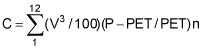

 P>PET or