![]()
![]()
![]()
In order to plan for fish farming development and to reduce economic risks, the areas where prospects are best have to be spatially defined using a number of criteria. This kind of study best lends itself to analysis in a geographic information system (GIS)2.
The basic step is to identify essential criteria for development (i.e., the most important factors) and to specify ranges of data (or thresholds) that pertain to a desired level of suitability for each criterion. For example, for the criterion water temperature, the range which gives optimum growth allowing two crops per year for the species under consideration here, Oreochromis niloticus and Clarias gariepinus, is t = > 26°C.
The second step is to locate, compile and prepare the data for computer analysis. An important constraint on this study was that the data already had to be in digital format in order to save on costs and to be easily incorporated in the GIS. This, in turn, necessitated that, in some cases, criteria had to be satisfied using surrogate data. For example, population density was used as a surrogate for local market potential.
A geographic information system was created for the analysis which evaluated the criteria on 10' (18 km × 18 km) grids3.
3 At the equator the grids are of this size, but decrease going north and south.
In overview, four main categories of criteria were employed to locate areas suitable for warm water fish farming in ponds: (1) growth and over-wintering, (2) water availability, (3) engineering capability for pond construction and (4) economics. For subsistence fish farming, six criteria were employed within the four categories and for commercial farming, eight criteria were used (Table 2.1):
Table 2.1 Criteria; Categories of criteria, and data used to define subsistence and commercial fish farming potential
| Criteria | Categories of Criteria Subsistence Fish Farming | Categories of Criteria Commercial Fish Farming |
| Water Temperature (Air Temperature) | Growth and Overwintering | Growth and Overwintering |
| Water from Rainfall Runoff (Annual Rainfall) | Water Availability | Water Availability |
| Water from Streams and Rivers (Perennial Streams and Rivers) | (not considered) | |
| Soil Texture | Engineering Capability | Engineering Capability |
| Topography (% Slope) | ||
| Local Market Demand (Population Density) | Economics | Economics |
| Inputs from Agricultural By-products (Crop Yield and Variety) | ||
| Road Infrastructure (Paved and Motorable Roads) | (not considered) |
The above criteria were assessed within 10' × 10' grids. For each criterion thresholds were established corresponding to optimum, suitable and marginal conditions for subsistence or commercial fish farming development. A more detailed account of the criteria and the classification of the data is given in the following sections.
Three steps were required to define growth and survival of fishes in terms of water temperature: (1) appropriate species were selected and their growth and over-wintering survival regimes were defined and temperature thresholds were established; (2) air temperature across Africa was synoptically interpolated and extrapolated; and (3) air temperature was converted to water temperature.
The objective was to map the temperature regimes most favourable for warm water fish farming given one and two crops per year. The species selected to portray opportunities for one and two crops per year were Oreochromis niloticus and Clarias gariepinus, fishes that are widely distributed and that already have performed well for fish farming. They are considered together in the study because their optimum temperature regimes are similar.
The optimal thermal range shown by Coche and Muir (Table 1, in prep.) for Oreochromis niloticus is 27–30°C and for Clarias gariepinus 25–27°C. The optimum regime adopted in the study, t => 26°C for 12 months, is a one degree compromise between the two optima. Because it encompasses the upper part of the ideal temperature range, it ensures good growth, if inputs are adequate, thus allowing for two crops each year.
A second temperature regime was set at t => 22°C for 12 months. For tilapias in general, at temperatures below 22°C, growth and reproduction are inhibited (ICLARM and GTZ, 1991). In this regime, temperature is sufficient to allow for natural reproduction and for reasonable growth throughout the year, thus allowing for two crops.
No upper limit was set on temperature. For both regimes it was assumed that water unavailability would limit fish farming before temperatures would become too high to negatively affect growth.
Keeping in mind that the study estimates warm water fish farming potential, a third temperature regime was set at t => 22°C for eight consecutive months to allow for reproduction and growth to a harvestable size in one season. Temperature was set at t => 14°C for the remaining months in order to ensure survival of brood stock over winter without special precautions.
There are no geographically comprehensive data on pond water temperatures in Africa. Therefore, air temperatures were used as a starting point.
Daily temperature data are not available at FAO in a digitized format. Daily temperature data for each of the stations in the country of origin are averaged by 10-day intervals (called decades) and then submitted to FAO to be entered in electronic data files. In order to keep computational requirements at a manageable level, mean monthly daytime temperature (MMDT) was employed as the measure rather than daytime temperature by the decade.
The MMDT data were prepared by the FAO Agrometeorology Group. A detailed account of the methods employed to realize the spatial distribution of mean monthly daytime temperature has been prepared by See and Gommes (1992). In brief, Africa temperature data from approximately 1,900 stations, mostly from the period 1931–1960, were used. The density of stations in agricultural areas, the areas of most interest in this study because of the need for agricultural by-products as inputs for fish farming, is satisfactory, but sparser coverage occurs elsewhere.
Daytime temperature is derived from daily minimum and maximum temperatures by taking into account the number of daylight hours. Daylight hours, in turn, are obtained from the latitude of the source of the observations and date on which the observations were made.
Station data were interpolated using kriging via the commercial software package SURFER. Latitude and altitude were taken into account as part of the interpolation process. The resulting temperature grids are 20 minutes on a side, equivalent to 37 km × 37 km at the equator.
In order to check the accuracy of the resulting temperature surfaces, agroclimatological data from 35 stations in extreme months were compared with temperatures in the nearest grids. Except for one station, the values at the grid points were very similar to actual station temperatures.
MMDT was converted to mean monthly water temperature (MMWT) using a model developed through regression of water temperatures from three ponds on air temperatures (raw data from C. Nugent, pers. comm., based on station records). The data were collected at the Henderson Research Station near Harare, Zimbabwe. The characteristics of the ponds and samples are listed in Table 2.2.
Daily daytime temperatures were derived from daily minimum and maximum air temperatures by the same process as outlined in Section 2.3.2. Daily water temperatures, taken at about 0700 and 1600, were averaged. In turn, monthly means were calculated from daily data. Because of missing data, there were some short months and in one case consecutive daily data were combined to make a long month of 39 days.
E-Pond was the most variable in temperature. Daily water temperature means differed from monthly means by a maximum of 6.8°C and the average difference was 4.6°C (Table 2.2).
Table 2.2 Physical characteristics, sample sizes and differences between daily and monthly water temperatures in three ponds in Zimbabwe
| Characteristic | E-Pond | H-Pond | J-Pond |
| Area (m2) | 160 | 225 | 10,000 |
| Depth Range (cm) | 30–120 | 20–100 | 0–175 |
| Days of Observations | 538 | 603 | 271 |
| Calendar Months of Observations | 20 | 22 | 9 |
| Maximum/Average Difference between Daily Mean and Monthly Mean | -6.8, +6.6 /-4.6, +4.4 | -4.2, +3.9 /-2.2, +2.1 | -5.2, +5.1 /-3.2, +3.9 |
Regressions of MMWT on MMDT for each of the ponds were significant and provided coefficients of determination of 0.88, 0.85 and 0.67 for E-, H- and J-Ponds, respectively. Because there was an overlap of the 95% confidence limits both on the slopes and on the intercepts, it was assumed that there were no significant differences among the air temperature-water temperature relationships of the three ponds. Therefore, the monthly data were pooled and a regression analysis on the pooled data provided the following model: (Fig. 2.1).
Figure 2.1 Mean Monthly Water Temperature as a Function of Mean Monthly Daytime Air Temperature (n= 51 Months)
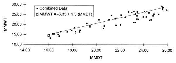
The coefficient of determination was 0.82. Ninety-five percent confidence limits on the intercept ranged from -10.13 to -2.58 and on the slope from 1.12 to 1.47.
Water for fish ponds was assessed using two sources. The first was rainfall runoff and the second was perennial rivers and streams. For subsistence farming, only rainfall runoff was considered, but both sources were used for commercial farming.
A relationship between mean annual precipitation and rainfall runoff was developed to assess water storage potential for irrigation in Africa (FAO, 1987). This relationship indicates that a mean annual rainfall as low as 550 mm would result in some storage in ponds. In Texas, USA, ponds are zoned according to rainfall. In zones with more than 1,000 mm of annual rainfall, ponds remain full throughout the year (AFS, 1986). In zones with less than 750 mm/y, radical draw downs occur during the driest months.
The availability of rainfall runoff water for ponds in Africa was examined by comparing fish farm pond densities by district with annual rainfall in the same districts. The choice of locations and countries was by default -- those for which second-level, sub-national boundaries (i.e., districts) had been digitized by the FAO GIS Centre and for which there were corresponding data on fish farm pond surface areas, also by district. Fish farm pond densities by district were available for all of Ghana (Kapetsky et al., 1991), for the Lake Basin Development Area of Kenya (Campbell, pers. comm.), for Zambia (Haight, pers. comm.) and for Zimbabwe (Nugent pers. comm.); there were 123 districts in all.
Mean annual precipitation data for Africa were obtained from UNEP/GRID in Nairobi in the form of an IDRISI4 image file with grid cells of 10' (18 km × 18 km at the equator). This data set was developed for the Global Assessment of Soil Degradation (GLASOD) using data from 1951–1980. A detailed description of the methodology is provided by Deichmann and Eklundh (1991). The GLASOD precipitation data are more complete and more reliable than those used in the irrigation study by FAO (1987) mentioned above.
The procedure was to attribute the total area of fish farm ponds to each respective district. In order to make the districts comparable, pond area was expressed in terms of pond density (m2) per km2 of district. The annual rainfall map, in intervals of 100 mm, was overlaid with the district maps and the prevalent rainfall interval pertaining to each district with fish farms was tabulated and plotted against pond density. The result clearly shows that most farms are found in districts with more than 1,000 mm annual rainfall (Fig. 2.2).
Figure 2.2 Annual Rainfall among 123 Districts with Fish Farms
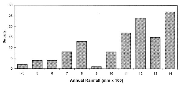
In Ghana, fish farms are found in districts that range from 1,000 mm to greater than 1,400 mm, with higher pond densities beginning at 1,100 mm and greater. In Ghana, personal observations of the author and discussions with fish farmers indicated that in districts with annual rainfall less than 1,100 mm difficulties in maintaining pond water are experienced.
In southwestern Kenya, fish farming is established in districts with 1,400 mm, or greater, rainfall, except for one district with 1,200 mm prevalent annual rainfall.
In Zambia, fish farms are found in districts that have ranges of prevalent rainfalls of from 700 mm to more than 1,400 mm. According to Haight (pers. comm.), commercial fish farmers in Zambia are able to maintain water throughout the year in low rainfall areas (e.g., 700 mm) by siting reservoirs so that they have large catchment areas.
In Zimbabwe, the relationship between pond density and annual rainfall is an apparent one. According to unpublished data from AGRITEX, more than 70% of fish farms in 25 of 29 districts in Zimbabwe depend on seepage of groundwater for their supply. Even in relatively high rainfall districts, seepage remains the most important supply. This corresponds to nearly all of the districts with rainfall of less than 900 mm.
On the basis of the four-country comparisons and the situation in the USA cited above, the effect of annual rainfall on fish farming potential is interpreted in the following way:
| Annual Rainfall (mm) | Interpretation |
| >1,199 | Ample |
| 1,000–1,199 | Sufficient with little or no special engineering |
| 700–999 | Sufficient with cost-adding modifications such as larger watersheds (more land acquisition), deeper ponds (higher construction costs, lowered fish productivity) |
| <700 | Insufficient unless groundwater is ample |
Perennial rivers and streams were considered as a source of water for commercial fish farming, but not for subsistence farming. Generally, capital and running costs for transporting water (pipes, pumps) would exceed the economic limitations associated with subsistence farming.
A digital map of perennial rivers and streams is part of the FAO GIS data set. The original data were generated by ESRI (1984).
Water availability from perennial rivers and streams was assessed in terms of presence or absence of perennial rivers and streams in 2' × 2' grids. Then each 10' × 10' pixel, the standard unit for analysis in this study, was examined for the numbers of 2' × 2' pixels containing perennial rivers or streams. A preliminary analysis showed that the maximum occurrence of 2' × 2' pixels with perennial rivers or streams was 23 out of a possible 25. A frequency distribution of the occurrence of 2' × 2' pixels within the 10' × 10' pixels was made. Water availability was cast into three classes with the following interpretation:
| Number of 2' × 2' Pixels Containing Perennial Streams or Rivers | Interpretation |
| 9–23 | Optimum |
| 5–8 | Suitable |
| 1–4 | Unsuitable |
The objective was to identify areas suitable for the construction of ponds. Two criteria were employed: soil texture and topography, with the latter indicated by slope. The FAO-Unesco Soil Map of Africa at 1: 5 million scale (FAO-Unesco, 1977) provides the basic data for both of these criteria (Fig. 2.3). The map was digitized at a resolution of 10'. The map units consist of a soil unit or of an associated of soil units. Each association is composed of a dominant soil and associated soils, the latter estimated to cover at least 20% of the delimited area. Soils which cover less than 20% are added as inclusions.
Figure 2.3 Reliability of the FAO-Unesco Soil Map of Africa
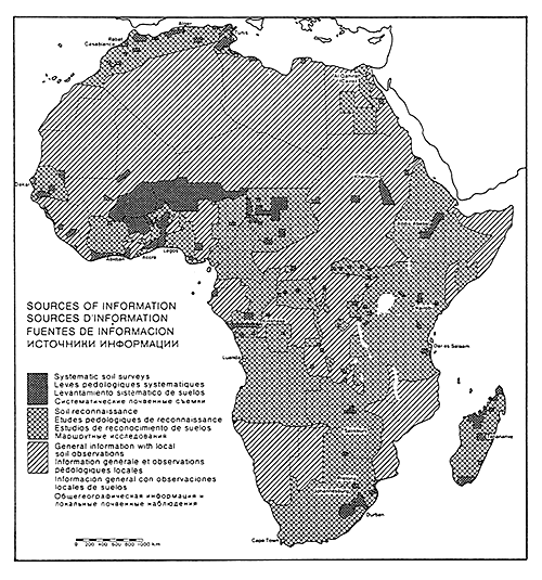
African soils are mapped with three classes of reliability. About 7% of the continent was covered by systematic surveys with sufficient ground control to be placed in Class I. About 38% is covered by reconnaissance maps with a Class II reliability and the remainder, about 55%, refers to virtually unexplored areas in a third class of reliability; however, this third class pertains mainly to thinly populated or semi-inaccessible regions.
The FAO-Unesco Soil Map of Africa includes three texture classes: coarse, medium and fine. These are given for the dominant soil of each association and refer only to the upper 30 cm.
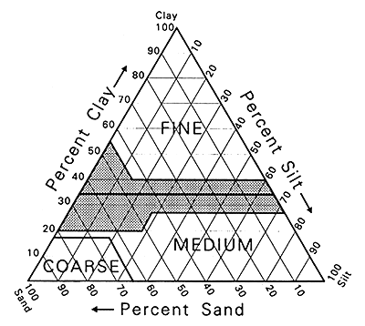
A soil texture triangle showing the best soils for fish pond construction has been prepared by Coche and Laughlin (1985) and has been overlaid with a triangle of soil texture prepared by FAO (1974) to illustrate the relationship (Fig. 2.4). Only coarse, textured soils are clearly not suitable for ponds. However, there are suitable soils among fine and medium textured soils.
Figure 2.4 A Comparison of the Best Soils for Fish Pond Construction with the Soil Texture Classes of the FAO-Unesco Soil Map of Africa
A further breakdown of soil texture into seven classes is listed by ESRI (1984) and takes into account the textural characteristics of all the soils in the association. Therefore, the information, referring to the area of the polygon with a given texture, is more complete than for the original FAO-Unesco classification.
Thus, the ESRI classification has been adapted herein with the original seven classes cast into four classes according to their suitability for ponds:
| Class | Texture | Interpretation |
| 1 | > 75% Fine | Very suitable |
| 50–75% Fine | ||
| 2 | > 75% Medium | Moderately suitable |
| 50–75% Medium | ||
| 3 | 50–75% Coarse | Marginally suitable |
| <50% All | ||
| 4 | > 75% Coarse | Unsuitable |
The interpretation of suitability for fish ponds in this study is based on the idea that, without identifying each individual soil type and without knowledge of the kind and extent of the other components, fine is better than medium and coarse is relatively unsuitable. Only the very suitable (Class 1) and moderately suitable (Class 2) have been used.
The FAO-Unesco Soil Map of Africa (FAO, 1977) includes three slope classes which reflect the topography in which the soil association occurs:
| Class | Dominant Slope (%) | FAO (1977) Interpretation |
| 1 | 0–8 | Level to gently undulating |
| 2 | 8–30 | Rolling to hilly |
| 3 | > 30 | Steeply dissected to mountainous |
For pond construction, the slope classes are intepreted in the following way, keeping in mind that even in Class 2 and Class 3 slope situations, there would be some opportunities for ponds:
| Class | Dominant Slope (%) | Interpretation for Pond Construction |
| 1 | 0–8 | Suitable for larger (1–5 ha) ponds, if slope is 1–2% and for 0.01–0.05 ha ponds, if slope is up to 5% (ICLARM and GTZ, 1991) |
| 2 | 8–30 | Mainly too steep for ponds, except in valley bottoms |
| 3 | > 30 | Too steep even for contour ponds |
Comprehensive economic data that could be used to indicate potential markets for aqua-cultured products and that are aggregated at administrative levels below that of the nation are available for only a few countries. Therefore, population densities have been used as a surrogate. The procedure is considered in two steps. The first step was to derive Africa-wide population estimates with the same base year. The second step was to interpret the population estimates in terms of local market potential for farmed fish.
Population density for Africa as inhabitants/km2 (i/km2) for the year 1988 on 5' (9 km × 9 km) grids was obtained from UNEP/GRID, Nairobi. The analytical procedures are presented by Deichmann and Eklundh (1991). In brief, the procedures they followed related population density to the interaction potential of population, that is, a measure of the theoretical concentration of people in a given region based on information about urban centres. Other factors were used to adjust the interaction potential, including proximity to the coastline, inland water bodies, railroads and roads. Areas known to be largely uninhabited were removed. Weights on the factors were based on an interactive heuristic approach. Using reference material, the impact of the weights was evaluated and the weights were adjusted until a satisfactory result was obtained. The resulting map is captioned on a non-linear scale (see Table 2.3, Col. 1, below).
This section proceeds in two parts. The first part establishes that local sale or barter is important even for the development of subsistence fish farming. The second part examines the relationship between population density and the occurrence of fish farming. Then, based on assumptions about farmgate sales, population density is interpreted as local market potential.
2.6.2.1 Importance of local markets
Local market potential is an important criterion for fish farming where transport systems are not well developed and where transport is expensive. These conditions characterize much of Africa. The importance of local markets pertains not only to commercial fish farms, but also to subsistence fish farming. Even with very modest yields and with little surface area devoted to fish ponds, part of the output is commercialized either through cash sales, or barter. For example, in Zambia in Luapula Province, 70% of the fish farmers treat fish farming as a commercial activity (Wijkstrom and Wahlstrom, 1992) even though average pond surface area per farm is less than 400 m2 and yields range from only 600 to 2,000 kg/ha/y (i.e., 24 to 80 kg/ha/y in the average pond). In Northwestern Province, results of two surveys show that from 65% to 76% of farmers both sell and eat the fish and more than half of what is produced is sold. In this province there was an average of 1,400 m2 of pond surface per farm and an average annual yield of 430 kg/ha/y (Wijkstrom and Larsson, 1992).
Similarly, in the Ruvuma Region of Tanzania, 66% of farmed fish from batch harvests was sold from farms with an average of 429 m2 of pond surface and mean annual yields of 1,300 kg/ha (Seki and Maly, 1993). It is reported that in Rwanda frequently two-thirds or more of the fish crop is sold. Ponds there were about 0.04 ha and yields ranged from 300–500 kg/ha/y before better management practices were introduced. Afterwards yields increased to 1,200 to 1,500 kg/ha/y (Nathanael and Moehl, 1989).
Another look at the same locations as mentioned above shows that in Luapula Province population density is relatively low. Using data from Kartzow, Heijden and van der Schoot (1992), the three districts with the highest pond densities have corresponding population densities of from >5 to <25 i/km2 and one district with a lower pond density has a corresponding population density of >1 to <5 inhabitants/km2. In the two districts with fish farms in Northwestern Province, population densities corresponded to >1 to <5 i/km2 for the district with the highest density of ponds and to >1 i/km2 for the one with the lowest pond density.
Although the data are not comprehensive, it is concluded that even at relatively low human population densities and with modest-sized farms and outputs, fish farming is often as much a commercial undertaking as it is a subsistence activity. Fish is sold or bartered very locally, to friends, relatives and neighbours. Therefore, the presence of local market demand can have a positive effect on fish farming development.
2.6.2.2 Population density and the occurrence of fish farms
If a part of the harvest is to be sold or bartered, it is reasonable to assume that the population density in the vicinity of the fish farm, the potential local market, is an important criterion for development. Simply stated, the more dense the population, the better the opportunities for local sale. This section sets out to establish a relationship between human population density and level of fish farming activity as measured by pond density.
Local market potential for cultured fish has been estimated by a procedure similar to that used to compare fish pond density with annual rainfall (Section 2.4.1). Fish pond densities per district for Ghana, southwestern Kenya, Zambia and Zimbabwe (123 districts in all) were from sources already listed. The population density data (Section 2.6.1) was used to establish the prevailing population density5 in each district with fish farms. This indicates that most fish farms are found in districts that range from >5 to <25 i/km2; however, there is another mode corresponding to districts with a prevailing population density of from >100 to <250 (Fig. 2.5).
Figure 2.5 Population Density in 123 Districts with Fish Farms
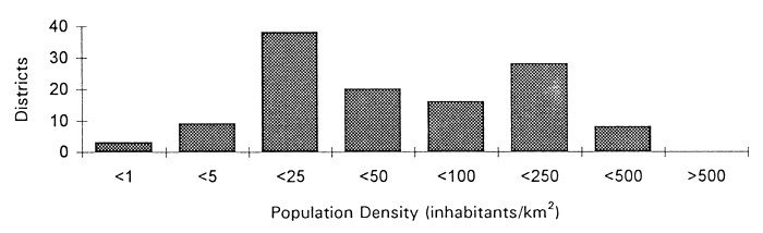
Fish farms do occur at densities of <5 i/km2 and a limited amount of data from Zambia and Tanzania indicates that even at these densities there are commercial activities, as pointed out in Section 2.6.2.1.
There is a tendency for the density of fish ponds per district to increase with increasing population density. However, because the population data are in rather broad ranges, attempting to develop a regression relationship is not justified. To examine the effect of local demand on fish farming potential, the following assumptions were made to estimate the number of subsistence and commercial farms that could be supported by farmgate sales at given population densities. The assumptions were:
Pond area of 0.04 ha and an output of 2 t/y for a subsistence farm; respective area and output for a modest commercial farm at 0.4 ha and 3 t/ha/y;
Farmgate sales confined to an easy walking distance, a 2 km radius of the farm for a subsistence farm; a 4 km radius for a commercial farm due to an implicit proximity to an all-weather road, making a commercial farm more easily accessible for walk in and drive in customers than for a subsistence farm.
A potential market of 1 kg of fish/person/year for a population within a 2 km radius for a subsistence farm and the same for a population within a 4 km radius for a commercial farm. One kg of fish/per caput is about 10% of all Africa mean fish consumption per caput.
50% of the output sold at the farmgate for a subsistence farm and 25% of the output for a commercial farm.
Based on these assumptions, Tables 2.3 and 2.4 show that population density would have to reach about 4 i/km2 to support farmgate sales of one subsistence farm and 6 i/km2 would be required to support on-farm sales of a commercial farm.
Table 2.3 Numbers of subsistence fish farms needed to meet demand for farmgate sales at given population densities
| Population Density (inhabitants/km2) | Inhabitants in a 2 km Radius and Demand @ 1 kg/i/y | Subsistence Farms in a 2 km Radius to Meet Demand | |
| GLASOD Ranges | Range Mid-Point | ||
| <1 | 0.5 | 6 | 0.2 |
| 1–4 | 2.5 | 31 | 0.8 |
| 5–24 | 15 | 189 | 4.7 |
| 25–49 | 37 | 465 | 11.6 |
| 50–99 | 75 | 943 | 23.6 |
| 100–249 | 175 | 2,199 | 55.0 |
| 250–499 | 375 | 4,713 | 117.8 |
Table 2.4 Numbers of commercial fish farms needed to meet demand for farmgate sales at given population densities
| Population Density (inhabitants/km2) | Inhabitants in a 4 km Radius and Demand @ 1 kg/i/y | Commercial Farms in a 4 km Radius to Meet Demand | |
| GLASOD Ranges | Range Mid-Point | ||
| <1 | 0.5 | 25 | 0.1 |
| 1–4 | 2.5 | 126 | 0.4 |
| 5–24 | 15 | 754 | 2.5 |
| 25–49 | 37 | 1,860 | 6.2 |
| 50–99 | 75 | 3,770 | 12.6 |
| 100–249 | 175 | 8,797 | 29.3 |
| 250–499 | 375 | 18,850 | 62.8 |
On this basis, the eight original GLASOD classes were cast into three classes to reflect local market potential for subsistence and commercial farming as shown in the following table:
Table 2.5 Interpretation of population density as local market demand for farmed fish for commercial and subsistence farms
| Original Classification (GLASOD) Inhabitants/km2 | Interpretation for Commercial Farms Inhabitants/km2 | Interpretation for Subsistence Farms Inhabitants/km2 |
| <1 | <5 Marginal | <1 Marginal |
| 1–4 | 1–4 Sufficient | |
| 5–24 | 5–24 Sufficient | <5 Ample |
| 25–49 | >25 Ample | |
| 50–99 | ||
| 100–249 | ||
| 250–499 | ||
| >500 |
According to the World Bank et al. (1991), numerous aquaculture ventures in Africa failed because they were not integrated into the rural and agricultural economy surrounding them. For successful integration, farms must have readily available by-products of agriculture for direct feeding or wastes for fertilizers. The need to develop semi-intensive fish feeding strategies that emphasize the use of simple feed ingredients and agro-industrial by-products available within the country was recognized by Tacon, Maciocci and Vinatea (1987). Given these considerations, the objective was to indicate the locations, availability and variety of agricultural by-products that could be used as inputs for fish farming. These can be related to agroclimatic suitability as measured by the length of growing period (LGP).
Agro-ecological zones for 11 main crops were defined for Africa by FAO (1978). Rain-fed crop production potential was assessed for high- (mechanized) and low-level (hand cultivation) inputs. In essence, crop climatic requirements were matched with the different climates of the agro-ecological zones to provide estimates of crop yields in relation to main climatic divisions and lengths of growing periods.
LGP was calculated from data collected from 730 stations and plotted at 30-day intervals at 1:5 million scale. An agroclimatic suitability assessment was made for each crop at two input levels by considering the whole agronomically possible yield range and classifying each individual LGP in terms of four ranges of yield capabilities:
| Maximum Yield Attainable (%) | Classification |
| >80 | Very suitable |
| 40 to <80 | Suitable |
| 20 to <40 | Marginally suitable |
| <20 | Unsuitable |
For this study crop potential was considered in the major climatic zones of Africa. The two most prevalent zones, Warm Tropic Lowlands and Warm Sub-Tropics with Summer Rainfall, both have 24-hour mean temperature regimes over the growing period of more than 20°C. These approximately correspond to lower limits of temperature specified for good fish growth in Section 2.3.
Nine crop types were examined in the warmer zones of Africa:
| Basic food grains: | rice, maize, pearl millet, sorghum |
| Root crops: | sweet potato, cassava |
| Leguminous food crops: | phaseolus bean, soybean |
| Cash crop: | cotton |
The basic LGP-crop suitability data for each climatic zone were taken from FAO (1978: Tables 10.1 to 10.11). In order to make a classification relevant to by-products for fish farming, each LGP was rated in terms of its yield potential for individual crops ( >80% of potential, from 40% to <80% of potential) and also for the variety (number) of crops for which it was very suitable, or suitable.
In terms of crop potential, it was assumed that very suitable gave an average yield of 90% (mid-range of 80–100%) and that suitable had a mean potential of 60% (mid-range of 40% to <80%). Thus, if a crop was tabulated as very suitable for a given LGP, it was given a score of 1.5 (90%/60% = 1.5); if suitable, a score of 1 (60%/60% = 1).
As the index of variety, the individual crop scores were summed after weighting for yield potential. Table 2.6 illustrates the outcome.
The final scores of each LGP for each climatic zone were cast into four classes and interpreted in the following way:
| Score Range | Abundance and Variety of By-products |
| 9–12 | Moderate to good quantities from varied crops |
| 4–8 | Moderate quantities from varied crops |
| 1–3 | Moderate quantities from few crops |
| 0 | Low quantities of by-products |
Infrastructure was considered as an important criterion for the development of commercial fish farming, but was not considered for subsistence farming. The density of paved and motorable roads was used as a surrogate for the general level of infrastructure. It was reasoned that where there are main, all-weather roads, there are better possibilities to transport inputs and supplies to fish farms and to send products to markets than in areas without such road infrastructure. It was also reasoned that where all-weather roads exist, the probability of other kinds of infrastructure in close proximity, such as electricity and communications, is enhanced.
Table 2.6 Crop productivity-variety occurences for each LGP interval in each major climatic zone in Africa and corresponding crop yield-variety scores
| LGP Type | LGP Days | Warm Sub-Tropics | Warm Tropical | Cool Sub-Tropics | Cool Sub-Tropics | Cool Tropical | ||||||||||
| Summer Rainfall | Lowlands | Summer Rainfall | Winter Rainfall | Highlands | ||||||||||||
| Number of Crops | Number of Crops | Number of Crops | Number of Crops | Number of Crops | ||||||||||||
| Very Suitable | Suitable | Yield- Variety Score | Very Suitable | Suitable | Yield- Variety Score | Very Suitable | Suitable | Yield- Variety Score | Very Suitable | Suitable | Yield- Variety Score | Very Suitable | Suitable | Yield- Variety Score | ||
| N | 365 | 0 | 0 | 0 | 0 | 1 | 1 | 0 | 0 | 0 | 0 | 0 | 0 | 0 | 0 | 0 |
| N | 330 to 364 | 0 | 0 | 0 | 0 | 4 | 4 | 0 | 0 | 0 | 0 | 0 | 0 | 0 | 0 | 0 |
| N | 300 to 329 | 0 | 0 | 0 | 0 | 4 | 4 | 0 | 0 | 0 | 0 | 0 | 0 | 0 | 1 | 1 |
| N | 270 to 299 | 0 | 5 | 5 | 0 | 5 | 5 | 1 | 1 | 2.5 | 0 | 0 | 0 | 1 | 1 | 2.5 |
| N | 240 to 269 | 1 | 6 | 7.5 | 1 | 6 | 7.5 | 2 | 3 | 6 | 0 | 1 | 1 | 2 | 3 | 6 |
| N | 210 to 239 | 2 | 7 | 10 | 2 | 7 | 10 | 3 | 2 | 6.5 | 1 | 0 | 1.5 | 3 | 2 | 6.5 |
| N | 180 to 209 | 5 | 4 | 11.5 | 5 | 4 | 11.5 | 3 | 2 | 6.5 | 1 | 0 | 1.5 | 3 | 2 | 6.5 |
| N | 150 to 179 | 6 | 2 | 11 | 6 | 3 | 12 | 3 | 2 | 6.5 | 0 | 1 | 1 | 3 | 2 | 6.5 |
| N | 120 to 149 | 0 | 0 | 0 | 1 | 8 | 9.5 | 0 | 0 | 0 | 0 | 1 | 1 | 0 | 5 | 5 |
| N | 90 to 119 | 0 | 0 | 0 | 0 | 8 | 8 | 0 | 0 | 0 | 0 | 1 | 1 | 0 | 5 | 5 |
| N | 75 to 89 | 0 | 0 | 0 | 0 | 7 | 7 | 0 | 0 | 0 | 0 | 1 | 1 | 0 | 5 | 5 |
| N | 1 to 74 | 0 | 0 | 0 | 0 | 7 | 7 | 0 | 0 | 0 | 0 | 1 | 1 | 0 | 5 | 5 |
| N | 0 | 0 | 0 | 0 | 0 | 0 | 0 | 0 | 0 | 0 | 0 | 0 | 0 | 0 | 0 | 0 |
| I | 1 to 74 | 0 | 0 | 0 | 0 | 0 | 0 | 0 | 0 | 0 | 0 | 0 | 0 | 0 | 0 | 0 |
| I | 75 to 89 | 0 | 0 | 0 | 0 | 7 | 7 | 0 | 0 | 0 | 0 | 1 | 1 | 0 | 0 | 0 |
| I | 90 to 119 | 0 | 0 | 0 | 0 | 7 | 7 | 0 | 0 | 0 | 0 | 1 | 1 | 0 | 0 | 0 |
| I | 120 to 149 | 0 | 1 | 1 | 0 | 1 | 1 | 0 | 0 | 0 | 0 | 0 | 0 | 0 | 0 | 0 |
| I | 150 to 179 | 0 | 6 | 6 | 0 | 0 | 0 | 0 | 3 | 3 | 0 | 0 | 0 | 0 | 0 | 0 |
The roads data were derived from the US Defense Mapping Agency (DMA) Topographic Maps of Africa and from the DMA Global Navigation and Planning Charts for Africa. The map was prepared at 1:5 million (ESRI, 1984). Because the data are old, the estimate of infrastructure is rather conservative for countries that have extended and improved their road systems in the last decade.
Road density was measured as the number of 2' × 2' pixels containing a paved or motorable road in each 10' × 10' pixel. The maximum road density possible is 25 pixels per each 10' × 10' pixel. In practice, the maximum encountered was 22. Thus, road density was cast into three classes nearly equal in number:
| No. of 2' × 2'Pixels Containing a Paved or Motorable Road per 10'× 10' Pixel | Interpretation |
| 9–22 | Optimum |
| 5–8 | Suitable |
| 1–4 | Marginal |
In overview, two kinds of warm water fish farming opportunities were identified by selection of criteria and by manipulation of thresholds within criteria. These were subsistence fish farming and commercial fish farming.
For subsistence farming six criteria were considered: rainfall runoff, water temperature, topography, soil texture, local market demand, and agricultural byproducts as inputs. The criteria and their respective class ranges are summarized in Table 2.7.
Table 2.7 Summary of Criteria and thresholds for subsistence fish farming
| Criterion | Class 1 Optimum | Class 2 Suitable | Class 3 Marginal |
| Water Temperature(°C) | =>26 for 12 mo. | =>22 for 12 mo. | =>22 for 8 mo. and =>14 for 4 mo. |
| Water from Rainfall Runoff (mm) | >1,199 | 1,000–1,199 | 700–999 |
| Topography (% Slope) | 0–8 | 8–30 | >30 |
| Soil Texture | Mainly fine | Mainly medium | Mainly coarse |
| Local Market Demand (Inhabitants km2) | >5 | >1 to <5 | <1 |
| Agricultural By-products (Production and Variety Score) | Moderate to good, varied (9–12) | Moderate, few crops (4–8) | Low (1–3) |
Eight criteria and their corresponding thresholds, summarized in Table 2.8 were used to define commercial fish farming opportunities.
Table 2.8 Summary of criteria and thresholds for commercial fish farming
| Criterion | Class 1 Optimum | Class 2 Suitable | Class 3 Marginal |
| Water Temperature (°C) | =>26 for 12 mo. | =>22 for 12 mo. | =>22 for 8 consecutive mo. and =>14 for 4 mo. |
| Water from Rainfall Runoff (mm) | >1,199 | 1,000–1,199 | 700–999 |
| Water from Perennial Streams and Rivers | 9–23 2'× 2' pixels/10'× 10' pixel | 4–8 2'× 2' pixels/10'× 10' pixel | 0–3 2'× 2' pixels/10'× 10' pixel |
| Topography (% Slope) | 0–8 | 8–30 | >30 |
| Soil Texture | Mainly fine | Mainly medium | Mainly coarse |
| Local Market Demand (Inhabitants/km2) | >25 | >5 to <25 | <5 |
| Paved and Motorable Roads | 14 to 22 2'×2' pixels/10'×10' pixel | 8 to 13 2'×2' pixels/10'×10' pixel | 1 to 7 2'×2' pixels/10'×10' pixel |
| Agricultural By-products (Production and Variety Score) | Moderate to good, varied (9–12) | Moderate, few crops (4–8) | Low (1–3) |
To provide an easily interpretable and manageable outcome, the six criteria for subsistence farming (Table 2.7) and the same six with two additional criteria for commercial farming (Table 2.8) were placed in four categories as has already been shown schematically in Table 2.1. The details of the analyses are set out in the Appendix, Sections 6.1 and 6.2.
The four categories were: (1) growth and survival over winter; (2) engineering capabilities for pond construction; (3) water supply, and (4) economics. The first category, growth and survival over winter, was used as the argument against which the other categories were assessed. It was used as the key category because the number of crops per year and production prospects associated with it are highly indicative of potential farm output. Thus, when analyzed with the other categories, the overall effect on output can be gauged. Further, in practical terms, the underlying criterion, water temperature, is the one which least lends itself to amelioration at the subsistence level. At the commercial level, its manipulation involves costly solutions such as greenhouses and heating of water using other energy sources. Said another way, water temperature is the criterion least easy to modify among the physical factors affecting fish farming feasibility and output.
From a commercial viewpoint, having two sources of water is less risky than a single source. Further, being able to use water from perennial streams and rivers has an advantage in areas where rainfall is seasonal, or low in supply.
Rainfall runoff was considered as a more important water source than perennial streams and rivers. Implicity, a given amount of rainfall is distributed homogenously throughout a pixel; however, as shown in Section 2.4, perennial rivers and streams are not so distributed. Intuitively, it is known that, even in 10' × 10' pixels with high occurrences of perennial rivers and streams, the amount of land in close proximity to the river or stream is only a very small part of an entire pixel. Therefore, water from perennial rivers and streams becomes important in instances where rainfall runoff is inadequate. Elsewhere, it can be considered as a supplementary source of water.
For purposes of the study, rainfall runoff was treated as being twice as important as water from perennial streams and rivers. The effect of combining the two criteria with this weighting is covered in the Appendix, Section 6.2.
The engineering category was derived by combining soil texture and slope with equal weights into optimum, suitable and marginal classes as shown in the Appendix, Section 6.1.
Economics for subsistence farming were derived by combining inputs and local market demand with equal weights. The table describing the outcome is in the Appendix, Section 6.1.
Economics for commercial farming were derived by adding road infrastructure to inputs and local market demand for commercial fish farming with equal weights on each criterion (Appendix, Section 6.2).
In line with the conservative approach of this study, marginal situations were not considered. That is, for any given pixel, if one of the four categories used to evaluate subsistence and commercial fish farming potential had a marginal rating, the pixel was eliminated from further analysis. Said another way, only areas that rated at least suitable were considered.
In order to illustrate a useful range of outcomes for interpretation, the results of the analyses were cast into main sequences in the following way:
| Two crops/y-Good Growth (Optimum) | |
| 1. | Two crops/y, good growth, other categories optimum |
| 2. | Two crops/y, good growth, other categories all suitable to 1 suitable and 2 optimum |
| Two Crops/y-Fair Growth (Very Suitable) | |
| 3. | Two crops/y, fair growth, other categories optimum |
| 4. | Two crops/y, good growth, other categories all suitable to 1 suitable and 2 optimum |
| One Crop/y-Fair to Good Growth (Suitable) | |
| 5. | One crop/y, fair to good growth, other categories optimum |
| 6. | One crop/y, fair to good growth, other categories all suitable to 1 suitable and 2 optimum |
| Marginal (Unsuitable) | |
| 7. | One to four categories marginal |
![]()
![]()
![]()