![]()
![]()
![]()
Five factors affect the study results and their interpretations. The first is the thresholds placed on each criterion; the second is the use of surrogate data; the third is the accuracy of the data employed; the fourth is the relative importance of each criterion in relation to how it was analyzed together with the other criteria, and; the fifth is the spatial resolution of the analysis.
The selection of threshold values profoundly affects the results because thresholds define the optimum, suitable and marginal areas. Wherever possible, thresholds were identified through literature searches (e.g., fish growth in relation to temperature) and through a combination of literature and analyses internal to the study (e.g., annual rainfall and local market demand in relation to locations of existing fish farms) and syntheses of information. Nevertheless, a judgement had to be made that involved some subjectivity. In this regard there was a conscious effort to err on the conservative side. For example, one of the critical thresholds was the minimum, safe over-wintering temperature of 14°C for the Nile tilapia. In retrospect, this may have been too high by one or two degrees as warm water fish farming potential is not predicted for Egypt, where Nile tilapia are farmed, but probably to no great extent in the small ponds that the present study uses as its model.
In the case of pond engineering characteristics, the thresholds were built into the original data. These were data sets created for agriculture, not aquaculture, and the data could not be manipulated to make texture and slope thresholds more sensitive to pond construction criteria. However, this defect has been noted.
With regard to local market demand, a key assumption was that local consumption would amount to 1 kg/person/y. If actually less, farmgate sales, or barter, would be less than anticipated and ultimately, a lower density of fish farms could be supported at given population densities than forecasted in the study.
Figure 3.25 Potential as Land Area by Country Commercial Fish Farming-One Crop/y with Fair to Good Growth
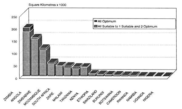
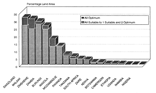
Figure 3.26 Potential as Percentage Land Area by Country Commercial Fish Farming-One Crop/y with Fair to Good Growth
The use of surrogate and derived data was necessary because no primary data were synoptically available for many of the most important criteria, such as surface water availability, water temperature and market demand. The question addressed here is the extent to which surrogate data actually represent a criterion.
Average annual rainfall is probably a relatively poor surrogate for surface water availability in areas where rainfall is highly seasonal, but serves well in other areas where rainfall is more evenly distributed throughout the year. The areas with seasonal rainfall are the very areas where availability of water to keep ponds full is likely to limit the development of fish farming. Therefore, by using conservative ranges for average annual rainfall, the results are likely to err by excluding some areas that may, in fact, be adequately supplied with sufficient surface water for fish farming.
Population density is a logical surrogate for local market potential. Implicit in this assumption is the idea that the greater the concentration of people, the higher the probability that the population will include people with sufficient purchasing power to buy farmed fish. No attempt could be made to adjust local market demand by using disposable income as an additional variable. Firstly, such data are not available for all of Africa at the sub-national level and secondly, much farmed fish is bartered, not sold for cash. Not taken into account here, but likely to have negative impact on commercial fish farming, is the likelihood that at very high population densities, land is probably too expensive to devote to fish farming.
The spatial resolution at which this study was conducted has been determined largely by default. It is a consequence of using already digitized data. Comprehensive data for Africa, such as the basic soil map that provided both texture and topography for this study, is at 1:5 million scale. It was digitized with a 10' resolution. Rainfall and population data were obtained at 10' and 5' grids, respectively. Because of spatial limitations on the interpolation procedure, temperature had to be generated for 20' grids. Nevertheless, considering that the objective was to provide an estimate of warm water fish farming potential on a continental scale, the spatial resolution is appropriate for this kind of strategic assessment.
This study employed large, varied and complex data sets that, with the exception of temperature, were generated to satisfy the needs of other investigations. Therefore, it would be impractical to check the accuracy of the original data. It can be taken for granted that there are some errors in the data themselves. More important for interpretation of the results of this study is a knowledge of how the analytical procedures and assumptions were combined to produce the estimates of fish farming potential. For this reason, the Materials and Methods were laid out in detail and a methodological appendix was added so that the details of the results of GIS analyses would be available to interested readers.
In this study the main argument against which all other criteria were evaluated was water temperature interpreted in terms of numbers of crops/y possible, fish growth potential and over-wintering without special precautions. This is justified because water temperature is directly related to yield potential. Apart from water management, there are no easy, inexpensive ways to increase and maintain higher water temperatures when one farms at subsistence level. Significant costs may be added to do so at a commercial level.
With the exception of water supply from perennial streams and rivers, all criteria were weighted equally when combined to make categories and weighted equally again when the categories were analyzed together to produce the final maps and tabular data.
There are two problems with weighting the criteria. The first is to have technical and economic data on which to base decisions about assigning the proper weights. For this, bio-economic models would have to be spatially linked to, or built into, the GIS. The problem is not one of a lack of technology to incorporate models, but rather one of a lack of basic data on which to build models.
The second problem is that, even with physical-biological and economic weights established, the reliability of the data (e.g., accuracy and spatial resolution) affects the weights. Thus, although it is known intuitively that water temperature and water availability are the most important of the physical criteria, the former is of relatively low spatial resolution and the latter is represented by a less than ideal surrogate. Thus, with these handicaps little would be gained by attempting to better quantify the relationships among criteria. In fact, a negative result might be obtained by seeming to put more reliability on the results than they deserve.
Comparison of GIS-predicted locations that have warm water fish farming potential with actual locations of fish farming is not a valid way to verify the results. This is because the study specifically predicts potential for warm water fish farming, rather than reports locations where fish farming is presently practised. Because warm water fish farming is so little developed in many African countries, much of the area predicted to have suitable to optimum potential does not encompass areas where warm water fish farming already is developed. A better test of the study results is to analyze areas where warm water fish farming is practised but where farming potential had not been forecasted. In this way the thresholds on criteria used in the study could be re-evaluated, if sufficient, diverse areas could be included. At present few data are available for verification in this way. In the Preparation of this Document section at the beginning of this report, knowledgeable readers are invited to send fish farm locations for this purpose.
An additional difficulty encountered in verifying study results is that, although there are scattered data on locations of fish farms in the literature, the data usually do not include the species cultured and are reported according to large-area administrative units. In comparison, the criteria used in this study are trans-boundary and are reported by 10' grids, a much finer resolution than that available to administrative units.
A final difficulty is that the most comprehensive data on fish farm locations, from 123 districts in Ghana, Kenya, Zambia and Zimbabwe, were used to establish thresholds on water availability and local market demand, thus disqualifying the results from those countries for comparison.
Given all of these difficulties, it is possible to make some crude comparisons of predicted potential with the actual distribution of fish farming in large administrative units. In Nigeria, Balarin (1990) lists 10 states of a total of 21 in which there is commercial fish farming. Two of the 10, in northern Nigeria, are not included in the potential fish farming area defined by this study because of relatively low annual rainfall. The other eight states in which there is commercial fish farming are in areas predicted to have potential.
In Cameroon, Balarin (1985) lists major fish farms by province. Major areas of the provinces which have the largest numbers of ponds are included in the suitable areas of this study. They are also included in the two provinces in which fish farming is best developed, as mapped by Satia, Satia and Amin (1992). There are suitable areas of varying sizes in the other provinces listed by Balarin (op. cit.). Also, as listed by Balarin (op. cit.), Nile tilapia are farmed in four of the six provinces.
In Tanzania Balarin (1985a) has tabulated rural fish pond numbers by administrative region. There is good correspondence between the regions of Tanzania with the largest numbers of rural fish ponds and the locations shown by the present study to have suitable to optimum warm water fish farming potential. At a finer resolution and with more recent data, numbers of fish pond farms have been listed by district for the Ruvuma Region in southern Tanzania by Seki and Maly (1993). There is a good overlap between two of the district boundaries and the areas predicted to range from suitable to optimum by the GIS. The areas of the districts where there is no overlap have limited warm water fish farming potential solely due to the coarse texture of soil, according to the GIS results.
The predictions for farming potential for Rwanda can be compared with the map prepared by Nathanael and Moehl (1989) which shows fish farming by region. Of the eight regions (all in the western half of Rwanda) where fish farming is practised, four overlapped with areas identified by the GIS as having fish farming potential. The regions overlapped by the GIS results tended to be those with the most communes practising fish farming and accounted for 63% of the active ponds in the eight regions. Areas with fish farming, but not identified as at least suitable for fish farming by the GIS, were marginal for slope, had water temperatures too low to meet the one crop/y criterion and were marginal as far as availability of inputs was concerned. Regarding water temperature, an especially cold-resistant strain of the Nile tilapia was imported and widely distributed to encourage fish farming in Rwanda. It appears to have a cold tolerance below that used in this study, 14°C, which may account for its wider use in fish farming in Rwanda than predicted by the GIS.
The central highlands of Madagascar, Vakinankaratra, offers an opportunity to make a comparison between the GIS results and actual fish farming because individual fish farm locations have been plotted by Lardinois (1992). In Vakinankaratra, the prevalent culture is carp in rice fields. The GIS results indicated that the area is too cool to meet the warm water fish farming temperature thresholds used in this study. Indeed, data tabulated by Ranaivoarijaona (1992) show that the altitudes of the 13 rain gauging stations in the region range from 915 to 2,100 m. Monthly mean air temperatures at 11 stations in the three coldest months exceed 14°C in only one month at only one of the stations. Slope greater than 30% is the only other criterion that is marginal in the area.
There are two ways in which the results of the study could be improved. One way is through the use of higher-resolution data for the criteria already considered and the second way is through adding criteria.
Higher resolution data are becoming increasingly available as GIS becomes more frequently used as a development planning tool. Temperature is the criterion most in need of improved data collection.
Some improvement in assessing surface water supply could be made by using monthly rather than annual rainfall data. In this way the seasonal availability of surface water could be compared with the seasonality of favourable temperatures for fish growth to optimize both where water is scarce. Data on availability of ground water would be a useful addition to information on surface water to assess fish farming potential in drier areas. Zimbabwe, where rainfall is relatively low, was shown to be a country where groundwater is the most important source of water for fish ponds.
The FAO slope classes that are associated with the soil map are too coarse to confidently gauge engineering suitability and similarly, and the FAO soil texture data do not correspond well to pond construction criteria. A 1:1 million soil map of Africa is under preparation and topography at 1 km resolution is becoming available, both of which could be used to make improvements in future studies.
An additional criterion to better focus on warm water fish farming opportunities is national park and reserved area boundaries so that fish farming potential is not mistakenly attributed to areas where other uses have priority.
![]()
![]()
![]()