![]()
![]()
![]()
This investigation is similar in many ways to a traditional site selection study for inland fish farming. That is, the study examines how well sites satisfy the physical and economic requirements of the culture system and how well four candidate species will perform at the sites under small-scale farming and two levels of commercial farming. It differs only in that a GIS is used to quantify the potential and in that the study is synoptic for all of continental Latin America. Each “site” that is being evaluated is an approximately 9 km × 9 km (at the equator) grid cell, of which there are nearly one-quarter million in Latin America.
Two important constraints were placed on this study in order to save on time and costs: only already digitized (i.e., computer-ready) maps were employed for the analyses, and field verification studies were limited to one country. An underlying objective was that the results had to be comparable for every area and every country of the continent. This imposed an additional constraint on the data: they had to be comprehensive for all of the continental countries. Most unfortunately, due to the lack of one gridded data set - mean monthly precipitation - it was not possible to include the Caribbean island countries in this study.
Throughout this study, four levels of suitability have been used in order to keep the analyses manageable and to make the results more easily comprehensible and comparable. The levels are very suitable (VS), suitable (S), moderately suitable (MS) and unsuitable (US). The interpretation is, in general, that the VS level provides a situation in which minimum time or investment is required in order to develop fish farming. For a level classified as S, modest time and investment are required, while if MS, significant interventions may be required before fish farming operations can be conducted. If the suitability level is US, the time or cost, or both, are too great to be worthwhile for fish farming.
The study was carried out in five steps:
Each grid cell was analysed as to its suitability for the culture system - farming fish in levee ponds - based on a combination of five physical and economic factors.
The importance of each factor was established relative to all of the others as commercial and small-scale fish farming models.
Each grid cell was analysed as to its fish production potential for four culture species at two levels of commercial farming and for small-scale farming using a yield model based mainly on water temperature, feeding levels and weights at harvest.
The commercial and small-scale site suitability models were used together with the species yield model to reach a combined evaluation of the suitability and yield of each grid for two levels of commercial fish farming and for small-scale fish farming.
The results were verified.
In more detail, for the first time known to us, a bioenergetics model was incorporated into a GIS to predict the number of fish crops possible per year over a large geographic area. A gridded temperature data set was used as input to the bioenergetics model to predict numbers of crops per year for four species: Nile tilapia (Oreochromis niloticus), tambaqui (Colossoma macropomum), pacu (Piaractus mesopotamicus) and carp (Cyprinus carpio). Among these species, Nile tilapia is being increasingly cultured in the warmer waters of Latin America because of its ease of culture, rapid growth rates, and tolerance to a wide range of water quality conditions. Carp is currently not widely cultured in Latin America. However, this species has a wide range of temperature tolerance and the potential for its culture is thought to be high. The characids (tambaqui and pacu) are commercially cultured in several countries (e.g., Brazil, Colombia and Venezuela) and are generally good candidates for pond aquaculture (Saint-Paul, 1989; Lovshin, 1995). Tambaqui generally performs well in warm waters (exceeding about 20°C) whereas pacu is more tolerant of colder temperatures.
By varying input levels and size at harvest, the performance of each species under two levels of commercial fish farming and for small-scale fish farming was evaluated for each grid cell. In addition to the suitability of each 9 × 9 km grid cell for the production of the above-mentioned species, each grid cell was evaluated for a number of other factors important for fish farm development and operation. These included:
urban market potential based on travel time proximity and population size of urban centres,
potential for farm-gate sales, based on population density,
engineering and terrain suitability for pond construction, using a variety of soil attributes,
water loss from ponds due to evaporation and seepage, and
availability of agricultural by-products as feed and fertilizer inputs, based on crop potential.
Commercial and small-scale aquaculture models were developed by weighting these factors using a multiple criteria evaluation procedure. Areas unavailable for inland fish farming development were identified by incorporating protected areas, large inland water bodies and urban centres as constraints.
Finally, the suitability of each grid cell for each of the four species was analysed together with the other factors through the commercial and small-scale models to identify those areas of the continental Latin American countries that ranged from very suitable to moderately suitable for inland fish farming at commercial and small-scale levels.
This study is aimed at individuals concerned with aquaculture. Therefore, this section contains only information sufficient to convey the analytical procedures and the rationale of the methods employed. For readers with an interest in GIS, a description of the digital data and GIS methodology used in this study is provided in Annex 1.
In all, five factors were considered in order to assess potential for commercial farming: urban market size and proximity; farm-gate sales; soil and terrain suitability for ponds; water loss; and agricultural by-products as inputs. All except urban market size and proximity were taken into account for small-scale farming.
The above factors are continuous in nature. Another set of constraints included in this study, such as reserved areas, exclude some geographical areas altogether. These constraints are dealt with at the end of the section.
Urban market potential pertains only to commercial fish farming in this study. It is assumed that small-scale fish farmers consume part of their production and either sell or barter the surplus locally. Urban market potential was defined using ideas of travel time proximity and market size based on population.
In terms of time, it was assumed that a 12-hour round trip from the farm to the market centre was the maximum possible in order to preclude the cost of the driver (and helper, if any) staying overnight away from the farm.
Time proximity was defined using the road system. Because of an oversight in classifying roads in the original data obtained from the Digital Chart of the World, Version 1 (ESRI, 1992a), it was necessary to assume that all roads were motorable and all-weather. A speed of 90 km/h was assumed for a truck travelling over these roads. Further, it was assumed that within each grid cell with a road system there also would be a feeder road system, not mapped, and that the truck travelled at one-fourth as fast as over the mapped road system (22.5 km/h).
Using the algorithm described in Annex 1, it was then possible to spatially define main and feeder road travel time combinations in four classes, with up to a maximum of 6 hours, or less, in one-way proximity.
Urban areas were defined using ARC/WORLD 1:3M data (ESRI, 1992b) and its accompanying classification system. The population data were re-classified in order to make four classes (Table 2.1).
Table 2.1 Classes of market potential based on population
| Suitability | Market Potential Classes | Original ARC/WORLD 1: 3M Classes |
| (inhabitants/km2) | (inhabitants/km2) | |
| Very Suitable | > 1 000 000 | > 5 000 000 |
| 1 000 000 – 5 000 000 | ||
| Suitable | 250 000 – 1 000 000 | 500 000 – 1 000 000 |
| 250 000 – 500 000 | ||
| Moderately Suitable | 50 000 – 250 000 | 100 000 – 250 000 |
| 50 000 – 100 000 | ||
| Unsuitable | < 50 000 | < 50 000 |
The two sub-factors, travel time and market size, were combined to make a consolidated factor “urban market size and proximity,” whereby each of the four urban size classes were combined with the four classes of time proximity and interpreted as urban market potential (see also Annex 1).
Market potential as farm-gate sales was inferred from population density (in individuals/km2 or i/km2) because no comprehensive marketing data were available on a scale compatible with that of this study.
Population density data were obtained from the National Center for Geographic Information and Analysis (Tobler et al., 1995). The basic assumption was that the greater the population density, the better the market opportunities for farmed fishes (Kapetsky, 1994). A second assumption was that there is a relationship among population density, land use and land cost so that at some point alternative uses of the land preclude its use for aquaculture. Thus, relatively high population densities become a constraint to the placement of a fish farm because of the increased probability of high land costs. For small-scale aquaculture that is pursued as one of a number of activities on a single-family farm, the density at which alternative uses displace farming is probably related to sub-urban population densities. Uniform, comprehensive definitions of “urban,” “sub-urban” and “rural” in terms of population density were not found in the literature. However, some indications were uncovered from other geographical regions:
Population size, density and surface area relationships were found for 51 European cities (Stanners and Bordeau, 1995). Among these data, the lowest population density of a denominated city was 485 i/km2, the smallest population was 12 386 and the smallest city area was 3 km2; however, about 41% of the cities had population densities ranging from 2 001 to 4 000 i/km2, the modal city area was in the range 101 to 200 km2 and about 80% of the cities were greater than 80 km2 in area.
In a study of land cover and population density in the Baltic Sea drainage basin, a population density of <200 i/km2 was used to denominate rural and >200 i/km2 urban (Sweitzer, Langaas and Folke, 1996).
The US Bureau of the Census considers a combination of 50 000 inhabitants and 386 i/km2 (=1 000 i/mile2) to be an urban area.
In a study on population growth and agricultural change in Africa, Turner, Hyden and Kates (1993) were able to find “rural” districts of more than 200 i/km2 uninfluenced in population density by urban concentrations within them. The “rural” districts had densities of up to 416 i/km2 and a median of 244 i/km2.
For this study, a population density of 300 i/km2 was used to indicate the limit at which land would become too expensive for small-scale fish farming. At a nominal grid cell size of 81 km2, this density corresponds to 24 300 individuals.
It was assumed that each grid cell defines the limits of the local market. The thresholds selected to indicate potential for farm-gate sales are given in Table 2.2.
Table 2.2 Thresholds to indicate potential for farm-gate sales, and the corresponding market size.
| Description | Threshold ranges | Potential market |
| (i/km2) | (maximum total inhabitants) | |
| Very Suitable | 150–300 | 24 300 |
| Suitable | 25–149 | 12 069 |
| Moderately Suitable | 1–24 | 1 944 |
| Unsuitable | 1 < and > 300 | n/a |
A good understanding of soil and its characteristics is one of the most important of the many factors which must be considered for successful freshwater fish culture (Coche and Laughlin, 1985). According to Yoo and Boyd (1993) the common soil properties most relevant to pond construction are slope, texture, organic matter content and sulphide content.
The objectives herein were to:
identify the soil and terrain parameters of the Digital Soil Map of the World (DSMW) (Version 3.5; FAO, 1995) most relevant to fish pond construction and operation, and
establish thresholds using the class ranges already established for each parameter in the original development of the FAO-Unesco Soil Map of the World (FAO/Unesco, 1974).
Appropriate soil parameters and their corresponding threshold values were taken from tables with soil limitation ratings for excavated fish ponds and for pond embankments, dikes and levees provided by Yoo and Boyd (1993). Index properties of soils for freshwater fish culture were taken from data tabulated by Coche and Laughlin (1985).
The DSMW was used to derive the soil and terrain suitability for fish ponds. This map is based on the FAO/UNESCO Soil Map of the World.
The original scale of the FAO/UNESCO Soil Map of the World is 1:5 000 000. The digital version, on rasters of 5 arc minutes, combines continental-level maps of soil associations and soil groups and derived soil properties as attributes. Included are software routines that interpret the maps in terms of agronomic and environmental parameters such as pH, organic carbon content, C/N ratio, clay mineralogy, soil depth, soil and terrain suitability for specific crop production, soil moisture storage capacity and soil drainage class. The output is given in the form of maps and data files which can be stored for later retrieval.
During the first attempt to classify the soil characteristics as to their suitability for fish ponds, much of Latin America scored low due to stringent thresholds on soil texture. Originally, the optimum class of soil texture was described as “Clayey without swell-shrink, and not organic” and the Suitable to Moderately Suitable class was “Loamy and not organic”. The thresholds were relaxed somewhat to “Loamy or clayey without swell-shrink, and not organic”. The final thresholds established are shown in Table 2.3.
Table 2.3 Soil parameters, suitability ranges and corresponding thresholds for estimating suitability for fish ponds.
| Soil and terrain property | Very Suitable | Suitable to Moderately Suitable | Unsuitable |
|---|---|---|---|
| Slope % | 0 – 2 | 2 – 8 | > 8 |
| Effective soil depth (cm) | > 150 | 75 – 150 | < 75 |
| Gravel and stones % | < 40 | 40 – 80 | > 80 |
| Soil texture | Loamy or clayey without swell-shrink, and not organic | Sandy, or clayey with swell-shrink, or organic | |
| Salinity (dS/m) | < 4 | 4 – 8 | > 8 |
| pH (H2O; 1:5) (fertility) | 7.2 – 8.5 | 5.5 – 7.2 | > 8.5 |
| < 5.5 | |||
| Catclays (sulphate toxic, very acid) | Not present | Not present | Present |
| Gypsum | Not present | Not present | Present |
Note: pH measured with a pH meter in the supernatant suspension of a 1:5 soil-water mixture.
Suitability values corresponding to those in Table 2.3 were calculated as percentages for each soil mapping unit and grid cell. For the overall evaluation of the soil suitability for ponds, it was assumed that Very Suitable is twice the value of Suitable, and weighting was carried out accordingly.
The main sources of water for levee and contour ponds are precipitation, runoff, pumped or gravity water from perennial water bodies such as streams, rivers, lakes and reservoirs, and pumped groundwater. However, it is difficult to comprehensively account for water availability from all of these sources in a continental-level study of fish farming potential such as this one. For example, perennial streams sufficient to supply a complex of ponds may not appear on digitized maps, and groundwater is not mapped at a continental scale. Therefore, for this study another approach was used, namely the estimation of monthly net water losses from ponds. This approach has the advantage that it indicates the amount of water that would have to be supplied in order to keep ponds full without pre-determining the source of the water. Another advantage is that water loss is estimated in centimetres and therefore no assumption about the area of the pond is necessary.
Water loss from ponds can occur primarily in two ways: evaporation and seepage. Monthly losses via these processes were computed as described below, and then accumulated to estimate annual net water losses.
The objective was to estimate the monthly net loss by evaporation from ponds.
The basic investigation of evaporation for this study is described in an internal FAO report (Estimating water requirements for small ponds in Latin America. AGLW, 1996).
Two temperature-based formulae were used to estimate evaporation: the Blaney-Criddle formula (Blaney and Criddle, 1950) and the Hargraves formula (Hargraves, Asce and Samani, 1982), of which the latter gave the best results.
The Hargraves approach takes into account air temperature and solar radiation. A coefficient of 1.15 was applied to convert the estimated evaporation into the amount of evaporation that probably occurs in shallow ponds.
Mean monthly minimum and maximum air temperature data have been collated by the FAO Agrometeorology Group from about 6 500 stations covering Latin America south of the USA, with some stations across the border in the USA. These data were interpolated to obtain a comprehensive air temperature data set at a resolution of 5 arc minutes. The interpolation procedure is briefly described below.
For each month, air temperatures were regressed against a set of variables (linear, quadratic terms) based on elevation and the geographic coordinates, leading to one continental equation accounting for at least 90% of the variance in the temperatures. These equations describe the “climatology” (i.e., the macro-effects). Subsequently, the departures from the “climatology” (residuals) were computed for each station. These corresponded to the local effects, expressed in degrees above or below the “climatology” prediction.
The continent was subdivided into 9 overlapping latitudinal slices of about 20 degrees each. Using the inverse distance weighting programme of Bogaert, Mahau and Beckers (1996), the residuals were then interpolated into a single continental map.
The final steps consisted of adding the interpolated residuals to the computed climatology, and assembly of the slices. The general patterns in the resulting map were comparable to the maps generated by Corbett (1993). However, it is considered that FAO Agrometeorology Group maps offer an improvement in that they are less sensitive to the geographic distribution of the observed points (stations) and better take into account the effects of relief features.
According to Yoo and Boyd (1993) seepage can be one of the most important causes of water loss from a pond. They state that seepage rates above 5.08 mm/d (15.4 cm/month, 185 cm/y) are undesirable in levee ponds and that properly constructed ponds often have seepage rates below 93 cm/y and few seep more than 232 cm/y.
These authors provide a range of seepage rates and categorize their importance (Table 2.4).
As a conservative estimate of seepage, a loss of about 100 cm/y was assumed for this study. This corresponds to approximately 8 cm/mo which is within the range of ponds that are categorized as having low seepage rates (Table 2.4).
Table 2.4 Categories of monthly and annual seepage rates (modified from Yoo and Boyd, 1993)
| Category | Rate (cm/mo) | Rate (cm/y) |
| Low | 0–14.7 | 0–176 |
| Moderate | 14.8–30.1 | 177–362 |
| High | 30.2–45.6 | 363–546 |
| Extreme | >45.6 | >546 |
Water loss was estimated by balancing inputs from precipitation against losses due to evaporation and seepage for levee ponds:
Water balance = (Precipitation × 1.1) - (Evapotranspiration × 1.15) - Seepage
The constant 1.1 in the precipitation portion of the above equation accounts for the runoff from the pond's sides that is in excess of the rainfall that falls directly into the pond.
Mean monthly precipitation data on 5-arc-minute grids were employed. These were prepared by Corbett (1993) using a tri-variate thin plate smoothing spline method.
With this approach, areas with two dry seasons could present a problem because the apparent net annual loss would be greater than either of the dry season losses. In order to determine the occurrence of two dry seasons, a set of sample points was defined at approximately 5° × 5°. Only one such area was found, at 25° S, 50 to 55° W, and thus the effect is minor and localized when the entire continent is considered.
The monthly net losses due to evaporation and seepage were accumulated to make a map of annual net water loss.
The presence of agriculture is an important indicator of aquaculture potential in two ways: first, agriculture implies at least a minimum amount of infrastructure for development, such as a road transportation system, a local labour force and villages or towns for essential supplies; and, second, there should be a source of by-products for fish feed or fertilizer.
For small-scale fish farming, agricultural by-products can contribute to higher yields than would be possible from the natural production of the pond. For commercial fish farming, use of by-products from agriculturally produced industrial food processing can reduce feed costs by allowing replacement of part of the formulated feeds otherwise needed.
Unfortunately, there are no comprehensive digital maps of agriculture crop types for Latin America that could be used to infer the availability of by-products as inputs. Therefore, crop potential was used as a surrogate.
Continental views of land with crop production potential are provided by Alexandratos (1995). An evaluation was made of the suitability of land for growing 21 crops under rain-fed conditions and various levels of technology. Two geo-referenced data sets provided the basic material for the evaluation: the FAO/Unesco Soil Map of the World (1974) and an inventory of climate regimes to characterize length of the growing period (LGP) (i.e., the length of the period of the year when moisture availability and temperature permits crop growth).
The original classification from Alexandratos (1995) (Table 2.5) was used to identify land with the capacity to produce agricultural by-products as inputs for fish farming.
Table 2.5 Productivity of major land classes in terms of length of the growing period (LGP) and land suitability (from Alexandratos, 1995).
| Major Land Class | LGP (days) | Land Suitability |
| Dominantly productive land | ||
| AT2 Moist semi-arid | 120–179 | 50% VS+S |
| AT3 Sub-humid | 180–269 | 50% VS+S |
| AT4 Humid | 270–365 | 50% VS+S |
| AT6 Fluvisols and gleysols | Naturally flooded land (NFL) | 50% VS+S |
| Dominantly marginally productive land | ||
| AT1 Dry semi-arid | 75–119 | 50% VS+S+MS |
| AT5 Moist semi-arid, sub-humid and humid | 120–365 | 50% MS |
| AT7 Fluvisols and gleysols mid and humid | NFL | 50% MS |
| Dominantly unproductive land | ||
| Partly suitable | 75–365 or NFL | 20–50% VS+S+MS |
| Mostly not suitable | 75–365 or NFL | 0–20% VS+S+MS |
| Not suitable, water, glaciers | n/a | n/a |
The following assumptions were made in order to re-classify the original rain-fed crop production potential (Table 2.4) in terms of the potential availability of inputs for aquaculture:
Assumption 1. Longer growing periods potentially provide inputs for aquaculture production over a greater part of the year. Scores for LGP are given in Table 2.6.
Table 2.6 Scoring of LGP for potential of inputs for aquaculture.
| Score | LGP (days) |
| 4 | 270 – 365 |
| 3 | 180 – 269 |
| 2 | 120 – 179 |
| 1 | < 120 |
In the case of naturally flooded land (AT6, AT7; Table 2.5), an arbitrary LGP score of 2 was assigned in order to account for unavailability of land for agricultural production due to seasonal flooding.
Assumption 2. Greater productivity per unit area potentially provides greater quantities of inputs per unit area of agriculture production. Scores according to the land productivity classification are indicated in Table 2.7.
Table 2.7 Scoring of land productivity for potential aquaculture inputs.
| Score | Land Productivity Classification |
|---|---|
| 4 | Dominantly productive land |
| 3 | Dominantly marginally productive land |
| 2 | Dominantly unproductive land |
| 1 | Not suitable, water, glaciers |
LGP and productivity scores from Tables 2.6 and 2.7 were combined as in Table 28.
Table 2.8 Combination of LGP and productivity scores as inputs for aquaculture.
| Original Class | LGP Score | Productivity Score | Scores Combined for Fish Farming |
|---|---|---|---|
| AT2 | 2 | 4 | 8 |
| AT3 | 3 | 4 | 12 |
| AT3 | 4 | 4 | 16 |
| AT6 | 2 | 4 | 8 |
| AT1 | 3 | 3 | 9 |
| AT5 | 3 | 3 | 9 |
| AT7 | 2 | 3 | 6 |
| Partly suitable | 2.5 | 2 | 5 |
| Mostly not suitable | 2.5 | 2 | 5 |
| Not suitable | 1 | 1 | 1 |
The scores from Table 2.8 were then aggregated into 4 classes with the score equal to the class number, as shown in Table 2.9.
For each 5-arc-minute grid cell, the percentage of each of the original classes (Table 2.5) was available from the DSMW. These 10 classes were grouped into the four classes shown in Table 2.9. Finally, the percentages of each of the four classes in each grid cell were added to obtain the final score for that grid cell.
Table 2.9 Reclassification of LGP-productivity scores into four classes.
| New Classes/Scores | Suitability | Score Thresholds |
|---|---|---|
| 4 | Very suitable | > 11 |
| 3 | Suitable | 7 – 10 |
| 2 | Moderately suitable | 3 – 6 |
| 1 | Unsuitable | < 3 |
The overall objective was to build models that combine the factors described in the preceding sections according to their relative importance for the development and operation of small-scale and commercial fish farming. Obviously, there are likely to be differences in the relative importance of these factors. Also, the importance of the same factors varies between small-scale and commercial fish farming, and according to the intensity of commercial fish farming. For example, the availability of agricultural by-products as feed inputs is relatively important in small-scale fish farming. In contrast, in commercial fish farming, where formulated feeds are used, the availability of such by-products is less important, except where they can be obtained as a cheap supplement to commercial feeds.
The factors are of two types: those, such as soil suitability for ponds, that are continuous; and constraints, such as reserved areas, that exclude some areas altogether. Constraints are dealt with in the final part of this section.
To summarize earlier sections, the factors considered to be important for the development and operation of small-scale (S) and commercial fish farming (C) and their interpretation for the models are given in the Box.
| Urban market potential (Market size and proximity) |
| S: Urban market potential was not used as a factor in estimating small-scale aquaculture potential. It is assumed that all small-scale aquaculture production is sold or bartered locally. |
| C: Takes into account population size of urban centres together with travel time over roads to the population centres. The maximum one-way travel time allowed from farm to urban market is 6 hours, and the larger the population of the urban centre, the greater the potential market for farmed fish. Implicit is the idea that urban markets are also locations from which farmed fish can be transported by air to other national destinations, or exported. |
| Farm-gate sales |
| This is based on the population density of the grid cell in which the fish farm resides. It is assumed that the higher the population density in close proximity to the farm, the greater the potential for farm-gate sales. |
| S: Sales or barter of surplus production is an important consideration in small-scale fish farming in parts of Africa, where even modest amounts are sold or bartered (Kapetsky, 1994) and a similar situation appears to exist in Latin America (Martinez-Espinosa, 1994; 1995). |
| C: For the commercial fish farmer, the high-volume sales at urban markets are much more important than “walk-in” customers who require staff time for the sale of only a few kilos per customer. |
| Soil and terrain suitability for ponds |
| Overall soil suitability is important from both an engineering and a productivity viewpoint. Soil characteristics considered include texture, slope, effective depth, pH, salinity, and the presence of catclays and gypsum. |
| S: Even though moderate limitations can be overcome without undue costs, for the small-scale fish farmer costs and time have to be minimized. Thus it is more important for the small-scale fish farmer to select a site that requires minimum modifications compared to the commercial fish farmer. |
| C: From the commercial farmer's viewpoint, the capital costs of corrective measures (e.g., lining, compacting, extra dike material) have to be taken into account, together with the increased running costs to replace water losses if corrective measures are only partially undertaken. |
| Water loss |
| Net annual water loss is based on evaporation and seepage. |
| S: From the small-scale farmer's viewpoint, it is difficult to replace water losses except naturally by rainfall and runoff. Pumping and piping are commercial-level operations to secure water and do not apply to small-scale aquaculture. Therefore, it is important to be in an area where the pond can be kept sufficiently full by rainfall and runoff to enable year-round fish culture. |
| C: From the commercial fish farmer's viewpoint, water loss can be thought of as running and capital “water costs” (e.g., pumps, pipes, fuel). |
| On-farm agricultural by-products |
| This factor refers to the potential availability of agricultural by-products for use as feed or fertilizer inputs, and is based on soil productivity and LGP. |
| S: It is important to be able to feed fish (or fertilize ponds) in order to achieve surplus yields that can be bartered or sold. |
| C: In commercial fish farming, where formulated feeds are used, the availability of agricultural by-products is less important, except where these can be obtained as a cheap supplement to commercial feeds. |
The procedure used to build the small-scale and commercial fish farming models is multiple-criteria, single-objective decision making. It is summarized by Eastman et al. (1993) and by Eastman (1995), and therefore described only briefly here.
The development of weights is based on pair-wise comparisons. The comparisons concern the relative importance of the two criteria involved in determining suitability for the stated objective. The ratings can be on a 9-point continuous scale as in Table 2.10; but, where it is felt that there is too much contrast between adjacent comparisons, additional comparisons can be added, such as “1/6” between 1/7 and 1/5.
Table 2.10 The relative importance of two criteria.
| 1/9 | 1/7 | 1/5 | 1/3 | 1 | 3 | 5 | 7 | 9 |
| Extremely | Very strongly | Strongly | Moderately | Equally | Moderately | Strongly | Very Strongly | Extremely |
| Less important | More important | |||||||
The model for commercial fish farming was based on the multiple-comparison method outlined above. Aquaculture experts from the FAO Inland Water Resources and Aquaculture Staff and a former FAO field staff member participated (Table 2.11).
Table 2.11 Expertise and international experience of FAO staff participating in the couple comparisons for the commercial model
| Expert | Aquaculture Expertise | International Working Experience |
|---|---|---|
| 1 | General, projects, research | Latin America, Global |
| 2 | Small-scale rural development | Latin America |
| 3 | Small-scale farming systems, extension | Africa |
| 4 | Nutrition | Latin America, Global |
| 5 | General, research | Pacific, Middle East, Global |
Establishment of values for the couple comparison was accompanied by much discussion based on differing views and perceptions of the factors and their relative importance. Careful definition of the factors was required. Consensus was reached and the outcome is shown in Table 2.12.
Table 2.12 Relative importance of commercial fish farming factors in couple comparisons (row versus column; e.g., water cost is strongly less important than market size and proximity).
| Market size & proximity | Water loss | Soil suitability | Agricultural by-products | Farm-gate sales | |
|---|---|---|---|---|---|
| Market size & proximity | 1 | ||||
| Water loss | 1/5 | 1 | |||
| Soil suitability | 1/7 | 1/5 | 1 | ||
| Agricultural by-products | 1/9 | 1/9 | 1/7 | 1 | |
| Farm-gate sales | 1/9 | 1/7 | 1/9 | 3 | 1 |
After the comparisons were made, the IDRISI Weight module (Eastman, 1995) was used to calculate the eigenvectors and to establish the consistency ratio of the results. The results are shown in the “Experts” column in Table 2.13.
Table 2.13 Relative importance of five factors for commercial fish farming development and operation.
| Factors | Experts | Author |
|---|---|---|
| Market size and proximity | 55% | 49% |
| Water loss | 25% | 27% |
| Soil suitability | 13% | 13% |
| Potential for agricultural by-products | 4% | 5% |
| Farm-gate sales | 3% | 6% |
The consistency ratio (0.2) of the expert group was unsatisfactory. However, the group's results were very similar to those generated by the first author using the same method well prior to the session with the experts, and the consistency ratio obtained by the first author was at an acceptable level, 0.07, so his model was used.
The individual factor maps were weighted according to their relative importance as shown in the table above. Because the grid cell of each factor map had already been classified as VS, S, MS or US, each cell was assigned a score obtained as the product of the weight of the factor and the suitability of the particular grid cell pertaining to that factor. These scores were then added for all factor maps. Finally, thresholds were established to arrive at a map of the overall suitability for commercial fish farming in four classes: VS, S, MS and US.
The small-scale model was established in a similar way to that of the commercial model. However, the role of the group of experts was limited to a discussion that clarified the factors and their relative importance. The multiple criteria comparisons were undertaken by Expert 3 (Table 2.11) and the first author working together. The consistency ratio, 0.07, was acceptable. The results of the comparison, after calculation by the IDRISI Weight module, are shown in Table 2.14.
Table 2.14 Relative importance of factors for the development and operation of small-scale fish farming.
| Factors | Relative importance |
|---|---|
| Water Loss | 51% |
| Potential for agricultural by-products | 19% |
| Soil suitability | 16% |
| Farm-gate sales | 14% |
The factors were combined to obtain a small-scle fish farming suitability map in the same way that the commercial map was constructed (as discussed above).
Fish growth models are useful tools for analysing factors that affect fish performance under culture conditions, and as management tools for fish production (Cuenco, Stickney and Grant, 1985). The use of such models in regional-scale planning applications (e.g., assessment of the production potential for different aquaculture species by the use of GIS tools) is not yet common, presumably because available models have either not been adapted for the wide variety of species needed to reflect aquaculture potential over large areas that encompass wide variations in climatic conditions, or they have not been packaged in a form that permits integration with GIS. Another possible reason is that such models can be used only when the relevant spatial and digital data are available to serve as inputs. Thus, the basic task here was twofold: to provide a synoptic water temperature data set for Latin America that could be used as one of the inputs of a growth model, and to modify an existing model to be used with GIS to provide yield outputs for four species.
The water temperature model is fully documented elsewhere (Nath, 1996) and briefly summarized in Annex 2. Validation of this model has been accomplished for different geographical locations by the use of daily weather and site-specific input data recorded in the tropical aquaculture database maintained by PD/A CRSP (Nath, 1996).
However, daily weather data required for the water temperature model are not easily available or accessible for large geographical regions such as Latin America. Moreover, manipulating and storing daily weather data for such a large grid are not trivial tasks. Even if capabilities for such operations are available, it is unlikely that there would be significant advantages of using them for strategic planning applications such as continental-scale analysis of aquaculture potential.
An alternative approach taken in the current study was to procure from the FAO Agrometeorology Group gridded data sets of the monthly values of air temperatures required for the water temperature model. Unfortunately, due to problems encountered during interpolations of recorded weather data, gridded data sets of the other weather variables required as input to the water temperature data sets were not available. Air temperature data were interpolated to obtain daily values for use in the water temperature model; other input variables were predicted by the use of a simple weather generator developed by Fritz, Meredith and Middleton, (1980). The analysis assumed that all the simulated ponds have a constant pond area of 2000 m2 and a depth of 1.2 m. Pond volume was consequently also assumed to be constant (i.e., 2 400 m3).
One-year simulations were conducted for each cell within the grid for Latin America using a one-day time step and the resulting daily water temperature values averaged for each month. The latter set of values was then used to generate maps of monthly mean water temperature. Because the model has been adequately tested only for conditions where the water temperature exceeds 0°C, a condition was inserted during map creation to plot the mean monthly air temperature instead of water temperatures < 0°C.
For use in the current study, an existing fish growth model (Bolte, Nath and Ernst, 1995) was modified. It is briefly described, with calibration and validation results, in Annex 3.
One-year simulations were conducted with the fish growth model for all four species. Daily water temperatures required for the growth model were obtained by linear interpolation of monthly means predicted by the water temperature model above. It was necessary to make minor modifications to the growth model in order to generate crops/y output. For example, it is difficult to specify exact stocking and harvest times for simulation runs relevant to a large geographical region because the time period required to reach the desired harvest size varies between locations. Further, depending on temperature preferences of different species, fish culture may be possible only during a certain period of the year, which is difficult to predict a priori. It was therefore assumed that a fish lot (population) would be stocked when water temperatures were favourable (arbitrarily defined as a 15-day period for which temperatures are within the range for which growth of the particular fish species is possible. The desired harvest weight for each species was also specified before a simulation run commenced.
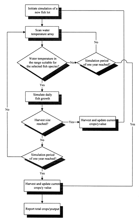
Figure 2.1 Flow diagram for calculating output (crops/year) using the simulation model of fish growth
During the simulations, the fish population was harvested if any of the following conditions were encountered:
the specified harvest weight (i.e., a full crop) was reached before one full year.
the simulation duration of one year was reached without registration of one or more crops, or
water temperatures were unfavourable for growth.
For the first case, if water temperatures continued to be suitable for the selected fish species, it was assumed that an additional fish lot would be stocked and harvested according to the above conditions. For the second and third cases, the crops/y output was expressed as a decimal fraction of the current fish weight relative to the harvest weight (i.e., a partial crop was reported). The simulation procedure is summarized in Figure 2.1.
In order to explore a range of commercial aquaculture possibilities by the use of the growth model, simulations were conducted for all four fish species, assuming two different feeding levels and two harvest weights. Natural food availability was assumed to be negligible. Feed application rates corresponding to 50% and 75% satiation were assumed to represent commercial aquaculture operations with low and high feeding rates, respectively. The primary effect of higher feeding rates as realized by the model is to enable more rapid fish growth, thereby enabling the desired target size to be reached earlier. The advantage of using percent satiation feeding levels instead of feeding rates on a percent body weight basis is that the former approach takes into account variations in the factors affecting fish appetite (see also Annex 3) during calculation of feed requirements. Within each of the percent satiation feeding levels, two harvest weights (small and large) were also established to enable consideration of market preferences for each fish species.
The stocking weight for tilapia, tambaqui and pacu was assumed to be 50g for all the scenarios; carp were stocked at 100g. A survival rate of 80% was assumed for all the simulation runs. Additional parameters assumed for commercial farming are indicated in Table 2.15.
Table 2.15 Stocking densities and harvest sizes (small and large) assumed within each of the commercial farming scenarios for the four fish species. Expected gross and net yields (after accounting for mortality) for a hypothetical output of 1 crop/y are also shown.
| Species | Stocking Density | Harvest Size | Gross Yield | Net Yield |
| (fish/m2) | (g) | (kg/ha/yr) | (kg/ha/yr) | |
| Tilapia | 3.0 | 300 | 7 200 | 5 700 |
| 1.5 | 600 | 7 200 | 6 450 | |
| Tambaqui | 1.5 | 600 | 7 200 | 6 450 |
| 0.9 | 1 000 | 7 200 | 6 750 | |
| Pacu | 1.5 | 600 | 7 200 | 6 450 |
| 0.9 | 1 000 | 7 200 | 6 750 | |
| Carp | 1.25 | 600 | 6 000 | 4 750 |
| 0.5 | 1 500 | 6 000 | 5 500 |
To achieve the overall objectives of this study and for easy interpretation of the results, it was necessary to aggregate crops/y outputs from the simulation runs into four classes. However, specification of rigid classes that pre-judge the value of the output without accompanying production cost and marketing data would not be appropriate. Furthermore, differences in model output were expected depending on the particular species, harvest size and feeding levels. To avoid these problems, output for each simulation scenario was divided into equal quarters of the range of crops/y. They are designated as 1st quarter (highest crops/y) (1stQ), 2nd quarter (2ndQ), etc.
It is difficult to precisely define small-scale, subsistence-level aquaculture operations because of the wide variety of materials used as inputs to these systems and variation in fish sizes that are harvested. In general, however, such systems are characterized by low-intensity management and smaller sizes of fish at harvest. Analysis of the potential for small-scale farming was limited to tilapia and carp only, because these two species effectively utilize natural food resources in ponds, as opposed to tambaqui and pacu which perform well primarily in ponds that receive artificial feed of relatively high quality.
Natural food availability was modelled as a function of fish biomass (Bolte, Nath and Ernst, 1995), an approach that requires definition of the critical standing crop (in kg/ha) or critical fish biomass (CFB; in kg/m3). For tilapia ponds that are not heavily fertilized or fed, a CFB of about 0.075 kg/m3 (equivalent to a fish biomass of 750 kg/ha) appears to be reasonable (Bolte, Nath and Ernst, 1995). This value also was assumed for carp ponds in the current study.
Parameters assumed for the simulation of both species under small-scale farming conditions are indicated in Table 2.16. These simulations assumed a survival rate of 80%.
Table 2.16 Stocking sizes, densities and harvest sizes (small and large) assumed within each of the small-scale farming scenarios for tilapia and carp. Expected gross and net yields (after accounting for mortality) for a hypothetical output of 1 crop/y are also shown.
| Species | Stocking density | Stocking size | Harvest size | Gross Yield | Net Yield |
| (fish/m2) | (g) | (g) | (kg/ha/y) | (kg/ha/y) | |
| Tilapia | 2 | 25 | 150 | 2 400 | 1 900 |
| Carp | 1 | 50 | 350 | 2 800 | 2 300 |
Model output as crops/y for tilapia and carp under small-scale simulation conditions was also divided into equal quarters (as described in the section on commercial farming above).
As shown above, the factors important for the development and operation of fish farming have been brought together in the form of commercial and small-scale model suitability maps, each with four classes ranging from VS to US. Similarly, the crops/y results from the growth models have been aggregated into four equal-length quarters for all four species within each commercial and small-scale fish farming scenario. In the final analytical step, these outputs were combined to make maps that showed the coincidence of each class of suitability with each quarter of crops/y output. For clarity in presentation of the maps, only VS, S and MS areas are shown in combination together with only the 1st, 2nd and 3rd quarters of crops/y yields.
The constraints included in this study were large inland water bodies and protected areas. Data for the latter constraint were obtained from the International Union for Conservation of Nature and Natural Resources (IUCN, 1992). Unfortunately, not all of the protected areas of Latin America are available in the form of digital maps. Thus, it is unavoidable that some protected areas may be shown in this study as having potential for fish farming.
These constraints were brought into the analyses at the fourth step of the study, at the point where the species crops/y outputs were combined with the commercial and small-scale model outputs.
The objective was to test the predictions of aquaculture potential made by use of the commercial model in combination with the yield model in terms of suitability of the grid cell “sites” and their yield in crops/y. The actual locations of operational farms were used as the arguments.
The verification study was confined to one country, Colombia, due to financial constraints. Nevertheless, Colombia is an important producer of cultured fish from inland waters (Table 2.17).
Table 2.17 Production from inland aquaculture in Colombia in 1993 (Fishery Information Data and Statistics Service, 1995)
Species | Production |
| (tonnes) | |
| Oreochromis niloticus | 11 046 |
| Piaractus brachypomum | 3 500 |
| Oncorhynchus mykiss | 2 028 |
| Cyprinus carpio | 60 |
| Macrobrachium rosenbergii | 10 |
Total | 16 644 |
Also, the mix of species indicates that Colombia is heterogeneous with regard to conditions for aquaculture development and for this reason, too, it is a good testing ground.
Farm characteristics were obtained by interview and locations by use of a global positioning system (GPS) instrument for 34 commercial farms among the eight departmentos (provinces) important for fish farming in the N, NW and central W portions of the country. The data were collected and compiled by personnel of the Instituto National de Pesca and Acuicultura from April to June, 1996, working under contract to FAO.
![]()
![]()
![]()