![]()
![]()
![]()
Mapa 10
AREA DE LOS ANDES
(NORTE)
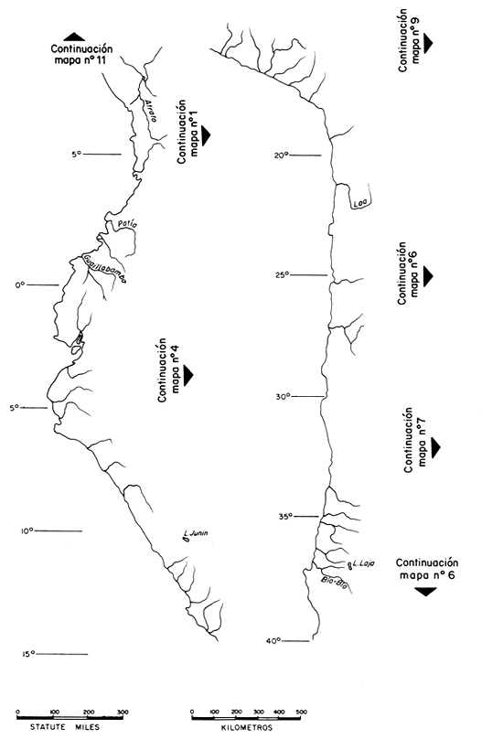
10. AREA DE LOS ANDES (NORTE)(Mapa 10) | 10. ANDES AREA (NORTH)(Map 10) | |
| (del Río Bío al Río Atrato) | (from Bío river to Atrato River) | |
| Del 19°S al 30°S hay ríos cortos (especialmente el Río Loa), lagos salinos y llanuras alrededor del área del desierto de Atacama. Hay también varios ríos cerca de Santiago(Río Maule) con menos de 300 km de largo. | From 19°S to 30°S there are only short rivers (specially the Loa river), saline lakes and fields around the area of the Atacama desert. There are also various rivers near Santiago (Maule River) less than 185 mi long. | |
| BIO BIO (Río) | BIO BIO (River) | |
| País: Chile | Country: Chile | |
Fuente: Lagos andinos Galletúe e Icalma, 71°15'0; 38°45'S | Source: Andean lakes Galletúe andIcalma, 71°15'W; 38°45'S | |
| Largo total: 380 km | Total length: 236 mi | |
Area de desagüe: 22 000 km2 (FAO, FisheriesDivision, 1961) | Drainage area: 8 495 mi2 (FAO, FisheriesDivision, 1961) | |
| Mayores afluentes: Bureo, Vergara, Laja | Major tributaries: Bureo, Vergara, Laja | |
Descargo en: Océano Pacífico, cerca deConcepción, 73°10'0; 36°48'S | Outlet: Pacific Ocean, near Concepción,73°10'W; 36°48'S | |
| Flujos máximos: 600 m3/s | Maximum flow: 21 189 ft3/s | |
| Flujos mínimos: 200 m3/s | Minimum flow: 7 063 ft3/s | |
| pH: 8.0 | pH: 8.0 | |
| Alcalinidad (M.O.): 51.3 ppm (Snyder, 1971) | Alkalinity (M.O.): 51.3 ppm (Snyder, 1971) | |
Principales especies de peces: En las secciones superiores de este arroyo se desarrolla una pesca intensa de la trucha arco iris (Salmo gairdnerii) y trucha común (Salmo trutta). Otras especies: Cyprinus carpio e Odontesthes mauleanum. (Soc.Chilena de Historia y Geografía, 1966) | Main fish species: The upper sections of this stream contain a good rainbow (Salmo gairdnerii) and brown trout (Salmo trutta) fishery. Other species: Cyprinus carpio and Odontesthes mauleanum. (Soc. Chilena de Historia y Geografía, 1966) | |
| LAJA (Lago) | LAJA (Lake) | |
| País: Chile | Country: Chile | |
| Localidad: 71°15'–23'0; 37°12'–29'S | Location: 71°15'–23'W; 37°12'–29'S | |
| Altitud: 1 200 m | Altitude: 4 000 ft | |
| Area: 100 km2 | Surface area: 39 mi2 | |
| Largo máximo: 35 km | Maximum length: 22 mi | |
| Ancho máximo: 10 km | Maximum width: 6 mi | |
Mayor río efluente: Laja, que corre unos 150 km hacia el río Bío Bío en S. Rosendo. | Major outflowing river: Laja, which flows about 100 mi to Bío Bío river at S. Rosendo. | |
Principal especie de pez: Salmo gairdnerii (peso medio de 1.5 kg) (Snyder, 1971) | Main fish species: Rainbow trout, Salmo gairdnerii (average weight 1.5 kg) (Snyder, 1971) | |
| Caracteres particulares: Pesca de deporte local | Special features: local sport fishery | |
| GUAYATAYOC (Lago) | GUAYATAYOC (Lake) | |
| País: Argentina | Country: Argentina | |
| Localidad: 65°48'–57'0; 23°13'–35'S | Location: 65°48'–57'W; 23°13'–35'S | |
| Area: 390 km2 | Surface area: 150 mi2 | |
| Largo máximo: 40 km | Maximum length: 25 mi | |
| Ancho máximo: 10 km | Maximum width: 6 mi |
| POZUELOS (Lago) | POZUELOS (Lake) | |
| País: Argentina | Country: Argentina | |
| Localidad: 65°57'–66°03'0; 22°17'–26'S | Location: 65°57'–66°03'W; 22°17'–26'S | |
| Area: 110 km2 | Surface area: 42 mi2 | |
| Largo máximo: 16 km | Maximum length: 10 mi | |
| Ancho máximo: 10 km | Maximum width: 6 mi | |
| VILAMA (Lago) | VILAMA (Lake) | |
| País: Argentina | Country: Argentina | |
| Localidad: 66°49'–57'0; 22°30'–39'S | Location: 66°49'–57'W; 22°30'–39'S | |
| Area: 90 km2 | Surface area: 35 mi2 | |
| Largo máximo: 18 km | Maximum length: 11 mi | |
| Ancho máximo: 9 km | Maximum width: 6 mi | |
| COLORADA (Lago) | COLORADA (Lake) | |
| País: Bolivia | Country: Bolivia | |
| Localidad: 67°45'–50'0; 20°11'–18'S | Location: 67°45'–50'W; 20°11'–18'S | |
| Area: 80 km2 | Surface area: 31 mi2 | |
| Largo máximo: 15 km | Maximum length: 9 mi | |
| Ancho máximo: 12 km | Maximum width: 7 mi | |
| LOA (Río) | LOA (River) | |
| País: Chile | Country: Chile | |
Fuente: al pie del volcano Miño cerca de la frontera boliviana; 68°38'0; 21°06'S | Source: at the foot of Miño volcano near Bolivian border; 68°38'W; 21°06'S | |
| Largo total: 440 km | Total length: 275 mi | |
| Mayor afluente: Salado | Major tributary: Salado | |
Descargo en: Océano Pacífico, 70°03'0; 21°26'S | Outlet: Pacific Ocean,70°03'W; 21°26'S | |
| SALINAS (Laguna) | SALINAS (Lagoon) | |
| País: Perú | Country: Peru | |
| Localidad: 71°05'–12'0; 16°20'–24'S | Location: 71°05'–12'W; 16°20'–24'S | |
| Area: 55 km2 | Surface area: 21 mi2 | |
| Largo máximo: 13 km | Maximum length: 8 mi | |
| Ancho máximo: 7 km | Maximum width: 4 mi | |
| PARINACOCHA (Lago) | PARINACOCHA (Lake) | |
| País: Perú | Country: Peru | |
| Localidad: 73°39'–45'0; 15°15'–20'S | Location: 73°39'–45'W; 15°15'–20'S | |
| Area: 65 km2 | Surface area: 25 mi2 | |
| Largo máximo: 11 km | Maximum length: 7 mi | |
| Ancho máximo: 8 km | Maximum width: 5 mi | |
| JUNIN (Lago) | JUNIN (Lake) | |
| País: Perú | Country: Peru |
| Localidad: 76°03'–15'0; 10°55'–11°05'S | Location: 76°03'–15'W; 10°55'–11°05'S | |
| Area: 150 km2 | Surface area: 58 mi2 | |
| Largo máximo: 24 km | Maximum length: 15 mi | |
| Ancho máximo: 13 km | Maximum width: 8 mi | |
| GUAILLABAMBA-ESMERALDAS (Río) | GUAILLABAMBA-ESMERALDAS (River) | |
| País: Ecuador | Country: Ecuador | |
| Fuente: 78°41'0; 0°37'S | Source: 78°41'W; 0°37'S | |
| Altitud: 4 000 m | Altitude: 13 100 ft | |
| Largo total: 320 km | Total length: 200 mi | |
Descargo en: Océano Pacífico enEsmeraldas, 79°38'0; 0°59'N | Outlet: Pacific Ocean atEsmeraldas, 79°38'W; 0°59'N | |
Caracteres particulares: En los últimos kilómetros recibe el nombre de Esmeraldas. El número de las especies de peces en Ecuador llega a 276 (Ovchynnyk, 1967) y el presupuesto de la producción en las aguas interiores a 1 000 t (FAO/UN, 1975). | Special features: On the last few miles called Esmeraldas. The number of fish species in Ecuador is close to 276 (Ovchynnyk, 1967) and the estimation of production in inland waters to a 1 000 t (FAO/UN, 1975). | |
| PATIA (Río) | PATIA (River) | |
| País: Colombia, Ecuador | Country: Colombia, Ecuador | |
Fuente: de dos cursos de agua en la frontera Colombo-Ecuadoriana, 77°43'0; 0°51'N | Source: formed by two headstreams on the Colombia-Ecuador border, 77°43'W; 0°51'N | |
| Largo total: 390 km | Total length: 240 mi | |
| Mayor afluente: Telembi | Major tributary: Telembi | |
Descargo en: Océano Pacífico; 78°55'0; 1°34'N | Outlet: Pacific Ocean,78°55'W; 1°34'N | |
| ATRATO (Río) (Mapa 1) | ATRATO (River) (Map 1) | |
| País: Colombia | Country: Colombia | |
Fuente: originado por dos principales cursos de agua, 76°32'0; 5°30'N | Source: formed by two main headstreams, 76°32'W; 5°30'N | |
| Largo total: 600 km | Total length: 375 mi | |
| Mayor afluente: Salaqui | Major tributary: Salaqui | |
Descargo en: Mar de Caribe (Golfo de Urabá), 77°10'0; 8°05'N | Outlet: Caribbean Sea (Golfo de Urabá,77°10'W; 8°05'N | |
Caracteres particulares: Navegable en el curso superior hacia Quibdó. Area de llanuras aluviales de casi 5 300 km2 entre 7°y 8°N; 77°30' y 78°15'0 en los ultimos cien kilómetros. Muchos pequeños lagos permanentes (ciénagas). | Special features: Navigable in the upper course up to Quibdó. Floodplains area between 7° and 8°N; 77°30' and 78°15'W of about 2 045 mi2 on the last 60 mi. Numerous small permanent lakes (ciénagas). |
![]()
![]()
![]()