![]()
![]()
![]()
N.B. The borders are those of the sub-division of Germany up until 2 October 1990
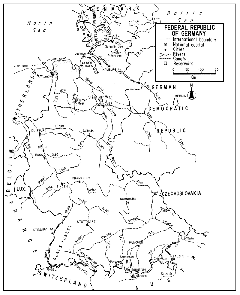
The Federal Republic of Germany is the heartland of north-central Europe. Bordered by nine countries, it extends from the North and Baltic seas across a series of plains and medley of hills and plateaux south to the Bavarian Alps.
Rich in coal resources and served by well organized river, canal, rail, and highway transport, it is one of the most industrialized nations in the world. Nevertheless, both agriculture and forestry remain important in its economy and it still maintains a considerable amount of productive inland water.
Within the Federal Republic of Germany, the streams range from great rivers such as the Rhine to small mountain brooks, and the lakes from large glaciated basins to high mountain tarns, but generally speaking the country is deficient in standing waters.
The discharge of effluent and the manifold uses of its resources of surface waters have played a heavy toll on several of its formerly extensive inland fisheries. Although the freshwater commercial capture fishery has declined severely, aquaculture especially for trout has made decided strides in both quantity and quality of production. Meanwhile as in most European countries, recreational fishing is assuming a greater importance.
1 Data given in this section refer to the Federal Republic of Germany up until 2 October 1990
| 1. | AREA: | 248 692 km2 2 |
2 Includes the area of West Berlin
| 2. | POPULATION: | 60 332 000 (est. 1990) | Density: 243 inh/km2 |
| 3. | PHYSICAL GEOGRAPHY | ||
The Federal Republic of Germany lies in north-central Europe between 47°16' and 55°04'N latitudes and 5°52' and 13°51'E longitudes.
Its greatest length (N–S) is about 876 km and its greatest direct E–W width is about 450 km. (The greatest distance between its extreme eastern and western points is, however, 627 km.) Its highest point, the Zugspitze, is 2 962 m; its lowest point is somewhat below sea level.
Bordered by nine countries, the Federal Republic of Germany (proceeding clockwise) is bounded: on the north by Denmark for 67 km, on the east by the German Democratic Republic for 1 378 km and by Czechoslovakia for 356 km, on the southeast and east by Austria for 784 km, on the south by Switzerland for 334 km, on the southwest by France for 446 km, and on the west by Luxembourg for 135 km, Belgium for 155 km, and the Netherlands for 576 km3. In addition to these national boundaries, the Federal Republic of Germany fronts for about 570 km (about 1 500 km considering indentations) on the North Sea, which lies west of the lower Jutland Peninsula (Schleswig-Holstein) and the Baltic Sea which lies east of this Peninsula.
The Federal Republic of Germany cuts across three of Europe's major east-west trending regions: the Great European Plain, the Central Uplands, and the Alps in the south. Thus, it encompasses areas ranging from its north coastal dunes, mudflats, polders and marshes which bound a great glaciated plain, south to a central area of low mountains, forests and basins which merges into a foreland plateau and culminates in the high-montane Alps of the extreme south.
Topographically, the Federal Republic of Germany can be divided into three (or four) great zones. Using the tripartite division, the sub-parallel-zones, each constituting about one-third of the country, are arranged from north to south as follows:
(i) North German Lowland or Plain. This is part of the Great North European Plain continuing into the low countries and southwest France on the west and extending east through Poland into the USSR.
Formed by glacial action, and mostly under 150 m in elevation, the northern Plain is gently rolling moraine with long low ridges and old glacial coastal valleys. Much of the area is sandy, health and moorland. Much has been converted into agricultural land; some is lakeland. It has a southern border (the Börde) of fertile loess.
Its embayed coast bordering the North Sea is flat and alluvial, protected by dikes, and fringed by lines of low sandy islands, the Frisians. The mud and sand are constantly shifting and channels require constant maintenance. The Baltic coast of the Jutland Peninsula is also flat, has sandy beaches, and a number of large islands. Unlike the North Sea it has almost no tide. It is characterized by long, deep winding inlets or drowned sub-glacial melt-water channels called Förden. The Peninsula also has some large lakes.
(ii) Central Uplands. South of the Plain is this central section or Mittelland. Topographically complex (a part of the old eroded Herycnian Massif), it includes low mountains dissected upland plateaux, down-faulted basins, and wooded areas. Extending south to the Danube, it varies in altitude from about 300 to 1 500 m. Its rocks are mostly ancient schists and sandstones with some volcanics, and its soils are thin and poor.
(iii) Bavarian Foreland and Alps. The Danube River flows easterly across southern Germany to its junction with the Inn where it enters Austria. South of the Danube is the Bavarian Foreland, a continuation of the Central Swiss Plateau. This area of plains and ridges, with beds of limestone, sandstone, and clay, which averages 300 to 900 m in elevation, rises to merge into the Allgau Mountains (west) and Bavarian Alps (east).
This Alpine chain, at most 40 km wide, stretches across the country between Lake Constance (the Bodensee) and the Austrian border (Salzburg) for about 240 km with a mean height of 1 830 m. In the west there are only low sandstone ridges, but the mountains south of München represent the northern or outer fringe of the limestone Alps.
The Alps here do not have glaciers, but contain mountain lakes. The forelands contain even larger moraine-dammed lakes, such as the Chiemsee.
(iv) Rhine Valley and Western Highlands. Although often included topographically with the Central Uplands, this portion of the Federal Republic of Germany, occupying most of the western and southwestern area of the country from Switzerland to the Netherlands, is sometimes considered a separate unit. As the Rhine proceeds north as the greatest unifying feature of the country, its landscape has many aspects: the dense Black Forest in the southwest, next the wide terraced rift valley of the upper Rhine, a narrow gorge between Bingen and Bonn, and finally its downstream lowlands. Meanwhile, as the river proceeds north, it increases in industrialization, river traffic and effluent content.
The Federal Republic of Germany lies in the mixed forest belt, but its once great deciduous forests (oak, linden, beech and birch) are largely gone. On the poor sandy soils of the north, the original forest has been replaced by heath and bog, and planted with Scots pine. The uplands contain beech and spruce, and cover in the mountains ranges from spruce, fir and pines to mosses and lichens at high altitudes.
The soils of the country are varied but generally not very fertile. They have been improved through drainage, tillage and fertilization. Those of the cold and damp Northern Lowland are badly leached soils, sands, acid podsols and peat bogs. Those of the Central Uplands are more varied: acid brown forest soils, podsols, and rendzinas. The Alpine soils tend to be thin, stony, and leached.
4. CLIMATE
The climate is temperate and mostly oceanic, affected favourably by the Gulf Stream. There is, however, some conflict between the western oceanic and the polar and continental air currents to achieve a range between the milder west European and the more extreme continental climates.
The average annual temperature, around 9°C, is almost constant throughout the country. In January, the coldest month of the year, temperatures average around freezing point in the lowlands, and about -6°C in the mountains. The average July temperature is 17–18°C in the northern lowlands, and reaches 20°C in the upper Rhine area.
The average annual rainfall is 800 mm, ranging from 500 to 700 mm in the northern lowlands to 700–1 500 mm in the central uplands, and to over 2 000 mm in the Alps. Rainfall is fairly uniform throughout the year although concentrated in the summer in the south.
The frost period lasts from 70 days a year in the west to 150 days in the east. Considerable snow falls in the winter: the northwest coast may receive 9 m and parts of Bavaria 16 m. The higher mountains are usually snowbound from January to March, and there is a permanent snowline at about 2 450 m in the Alps. During a low presure system, the Föhn (a warm dry wind) may melt snow in the spring.
The Baltic Sea which is only brackish may be frozen at times so that its German ports are closed. On the Rhine the area near Cologne may be frozen over for 20 days, and Lake Constance, at 395 m, has frozen over 30 times since the year 1000.
5. HYDROGRAPHY AND LIMNOLOGY
The Federal Republic of Germany has about 4 600 km2 of inland water according to Gallus (1979). This estimate, which equals about 1.8 percent of the area of the country, should be one of the best available. An earlier estimate (also based on information from the Federal Republic of Germany) was that in EIFAC (1960) and in Framji and Mahajan (1969) which listed the inland water area of the Federal Republic of Germany as 4 203 km2 or 1.7 percent of the total area. Another is that derived from Table 7 where inland water constitutes 4 300 km2 or 1.7 percent of the Federal Republic of Germany1.
The average annual runoff from rainfall in the Republic is 307 mm or 77 000 million m3. About 85 000 million m3 is received annually from upstream countries, resulting in a total annual river discharge of 162 000 million m3 leaving the country (Van der Leeden, 1975; ECE, 1978).
The greater part of the country drains to the North Sea via the Rhine, Ems, Weser, Elbe, and some minor streams in the northwest. (A very small portion of the country drains easterly through the Rur to enter the Mass system outside the Federal Republic of Germany and also proceed to the North Sea.) The Baltic Sea is fed by a few streams originating in Schleswig-Holstein. The southern portion of the Republic is drained primarily by the Danube which proceeds eventually to the Black Sea.
5.1 Rivers (Flüsse)
The major rivers of the Federal Republic of Germany are shown in Table 1, and the discharges of some of the principal rivers are listed in Table 2.
The regimes of the Federal Republic of Germany rivers fall generally into two groups: (i) those of the Alpine rivers, and (ii) those of middle and northern Germany.
Table 1
Principal (navigable) rivers of the Federal Republic of Germany
| Length (km) | ||||
| River | Within the country | Navigable | Basin area (km2) | |
| Danube (Donau) | 647 | 386 | 56 215 | |
| Rhine (Rhein) | 865 | 778 | 102 111 | |
| Neckar | 367 | 203 | 13 958 | |
| Main | 524 | 396 | 26 507 | |
Regnitz | 58 | 5 | 7 540 | |
| Lahn | 245 | 148 | 5 947 | |
| Mosel | 242 | 242 | 9 387 | |
Saar | 120 | 120 | 3 575 | |
| Ruhr | 213 | 41 | 4 489 | |
| Ems | 371 | 238 | 12 649 | |
| Leda | 75 | 27 | 1 917 | |
| Weser | 440 | 440 | 41 094 | |
| Fulda | 218 | 109 | 6 947 | |
| Werraa | 292 | 89 | 1 417 | |
| Allera | 211 | 117 | 14 446 | |
Leinea | 241 | 112 | 6 006 | |
| Lesum/Wümme | 128 | 29 | 2 225 | |
| Hunte | 189 | 26 | 2 785 | |
| Geeste | 43 | 29 | 337 | |
| Oste | 160 | 82 | 1 714 | |
| Elbe | 227 | 227 | 14 945 | |
| Ilmenau | 107 | 29 | 2 869 | |
| Este | 50 | 13 | 361 | |
| Luhe | 55 | 13 | 204 | |
| Schwinge | 35 | 5 | 199 | |
| Pinnau | 44 | 20 | 358 | |
| Krückau | 37 | 11 | 247 | |
| Stör | 88 | 51 | 1 800 | |
| Eider | 188 | 112 | 1 891 | |
| Trave | 118 | 53 | 1 854 | |
a Including share of the German Democratic Republic
Source: Statisches Jahrbuch 1989 für die Bundesrepublik Deutschland (1989)
(i) Alpine rivers. The streams rising in the Alps, such as the Danube and its southern tributaries, have their lowest flow in the winter and highest in May–June following snowmelt. The upper Rhine above Basel is also an Alpine stream. Although regularized by Lake Constance (the Bodensee) its flow is increased below the lake by receiving that of the Aar from Switzerland and continues with high volume and rapid current during June–July, subsiding to its low flow in February1.
Table 2
Discharge of seven rivers in the Federal Republic of Germany
| River and station | Mean monthly discharge, m3/sec | Daily discharge m3/sec | |||||||||||||||
| Basin area (km2) | Jan. | Feb. | Mar. | Apr. | May | June | July | Aug. | Sept. | Oct. | Nov. | Dec. | Year | Max. | Min. | Period of record | |
| Danube, Hofkirchen | 47 496 | 605 | 687 | 779 | 731 | 678 | 724 | 737 | 605 | 534 | 516 | 543 | 530 | 639 | 3 830 | 193 | 193160 |
| Rhine, Rees | 159 680 | 2 560 | 2 840 | 2 660 | 2 450 | 2 050 | 2 200 | 2 170 | 1 900 | 1 700 | 1 650 | 1 970 | 2 390 | 2 210 | 9 440 | 590 | 193665 |
| Main, Kleinheubach | 21 505 | 134 | 193 | 197 | 190 | 136 | 148 | 81.7 | 70.1 | 60.9 | 72.2 | 115 | 196 | 133 | 857 | 13.8 | 196065 |
| Mosel, Cochem | 27 100 | 535 | 555 | 429 | 324 | 201 | 158 | 135 | 125 | 124 | 168 | 314 | 427 | 291 | 3 730 | 22 | 193160 |
| Ems, Versen | 8 469 | 136 | 139 | 114 | 79.5 | 44.7 | 28.8 | 35.8 | 33.6 | 35.5 | 49.8 | 77.6 | 105 | 73.5 | 1 200 | 5.2 | 193160 |
| Weser, Intschede | 37 788 | 450 | 498 | 478 | 379 | 246 | 206 | 210 | 185 | 171 | 199 | 277 | 357 | 305 | 3 300 | 59.2 | 193160 |
| Elbe, Neu-Darchau | 131 951 | 725 | 843 | 1 100 | 1 130 | 766 | 591 | 571 | 486 | 448 | 478 | 597 | 652 | 700 | 3 620 | 145 | 193160 |
Source: Van der Leeden (1975) after Bundesanstalt für Gewasserkunde und Deutsche Forschungsgemeinschaft, 1972
(ii) Central and northern rivers. As opposed to the Alpine rivers, these lowland streams have their strongest flow in winter and spring (December to April) and their lowest flow from June to October. Despite summer rains in their catchments, there is also a high evaporative rate during this period, and winter rains fall on saturated or frozen soil and reach the rivers quickly. Differences do exist between middle and northern rivers in the Federal Republic of Germany due to differences in terrain, declivity, and evaporative rate. The ratio between high and low flows may also differ considerably (e.g., it is 40 to 1 for the Lahn and 18 to 1 for the Main), and on the northern plain the rivers are more constant and slower. Nevertheless, the regimes are similar.
As has been customary in several parts of the world, early attempts were made in Germany to classify river zones on the basis of their dominant fishes. Thienemann (1925), for example, outlined six successive zones as one descends a German river:
An even more elaborate classification is that of Illies (see Ladiges and Vogt, 1979) shown below:
| (i) | Rithon | ||
| Epirithron | - Upper salmonid region: upper trout zone | ||
| Metarithron | - Middle salmonid region: middle trout zone | ||
| Hyporithron | - Lower salmonid region: grayling zone | ||
| (ii) | Potamon | ||
| Epipotamon | - Upper cyprinid region: barbel zone | ||
| Metapotamon | - Lower cyprinid region: bream zone | ||
| Hypopotamon | - Ruffe - flounder region | ||
Similarities between these zones and those described by other scientists are obvious (see, for example, section 5 for Belgium, France, and the UK).
The major river systems of the Federal Republic of Germany are described below.
Rhine (Rhein in German/Rhin in French). The Rhine with a total drainage area of about 160 000 km2 and length of 1 350 km, is the most important waterway in Europe. Once a great salmon river, and one which supplies drinking water to about 20 million people, it has also been termed the “cloaca” or “sewer” of Europe. In its use, it typifies western Germany. Originating in Switzerland, it forms a partial border between it and the Federal Republic of Germany below Lake Constance. Upon leaving Switzerland at Basel, it turns northeast through a 30–50 km rift valley, forms a German/French border downstream to the Lauter River, passes through a series of gorges and flanking coalfields, and finally flattens out to continue through Germany and the Netherlands to its deltaic mouth in the North Sea1.
Flow in the Rhine is rather neatly balanced by a summer maximum from snowmelt in the Alps and a winter maximum from the lower tributaries, mainly from the Central Uplands. The latter flow comes at a time of year when the lower stream is more responsive to precipitation to maintain its level. The result is a river with powerful and sustained flow well suiting it for navigation.
As the Rhine leaves Basel, it has an average discharge of 1 040 m3/sec. As it enters the Netherlands from the Federal Republic of Germany, it has an average discharge of about 2 200 m3/sec, a maximum of about 12 200 m3/sec, and a minimum of 590 m3/sec. Its average flow has doubled with the inflow of the pluvia-nival rivers of the Mittelland.
The Rhine is a great river upstream to the Rheinfalls (see Switzerland), being navigable for 778 km of its 865 m course in the Federal Republic of Germany. An international waterway since the Treaty of Vienna in 1815, it supports a heavy traffic of cargo ships, barges, and passenger vessels, and serves as a giant effluent channel for central Europe2. Duisberg is the largest inland port on the Rhine.
2 Die Zeit once termed the Rhine: “a navigable canal filled with industrial wastewater”
Neckar. Proceeding downstream, the first important German tributary of the Rhine is the 367-km Neckar which rises in the Black Forest close to the headwaters of the Danube. Draining the southwest of the Federal Republic of Germany, it proceeds northerly to join the Rhine from the right at Mannheim. During the 1960–65 period, it had an average discharge of 124 m3/sec and estimated maximum of 2 500 m3/sec at Rockenau.
Main. The Main, which flows almost completely across the Federal Republic of Germany from the east, for 524 km between the Central Uplands and Alpine Foreland, to join the Rhine at Mainz, is its most important right bank tributary. Navigable for 396 km, it connects with the Danube through the Main-Donau Canal.
Continuing downstream, other right bank tributaries of the Rhine, are the 245-km Lahn, 130-km Sieg, the 213-km Ruhr, and the 237-km Lippe, in that order.
Mosel (Moselle in French). The 505-km Mosel is the most important left bank tributary of the Rhine in Germany. Rising in the Vosges in France, it flows between Luxembourg and the Federal Republic of Germany for 40 km, leaves Luxembourg after its confluence with the Sûre at Coblenz, and continues through Germany to the Rhine. Its course in the Federal Republic of Germany is 242 km, all of which is navigable. The Mosel has a low gradient and has been canalized and levelled to permit cargo traffic. The most important tributary of the Mosel in the Federal Republic of Germany is the 120-km Saar from the south.
Another important left bank tributary of the Rhine in the Federal Republic of Germany is the 97-km Nahe, entering at Bingen above the mouth of the Mosel. The Ruhr basin is highly industrialized, furnishing most of the country's coal, steel, and smelting metals, and using industrial power from coal.
Ems. A large part of the North German Lowland is drained by the slow-flowing 371-km Ems, which flows northward from the Central Uplands to parallel the Dutch border and debouch through a 32 km estuary, the Dollart, in the North Sea. Canalized, it is navigable for 238 km.
Weser. Formed by the junction of the north-flowing Fulda and the Werra, the 440-km Weser flows north to drain part of the lower Central Uplands and central portion of the Northern Lowlands. It enters the North Sea at Bremenhaven between the Ems (to its west) and the Elbe (to its east), and is connected with each river by the Mittelland Canal.
Elbe. Last of the large north-flowing rivers of the Federal Republic of Germany is the Elbe which rises in Czechoslovakia and flows for 1 137 km, through the Democratic Republic of Germany and then through the Federal Republic of Germany to the North Sea at Cuxhaven. Only 227 km of the Elbe are in the Federal Republic of Germany, but the important city of Hamburg, with 64 km of quays, is situated at the upper end of its 110-km estuary.
Danube (Donau) or Black Sea Drainage. The line between the Rhine and Danube basins extends across southern Germany, so that the Danube River receives its drainage from the Black Forest on the west as well as from the Bavarian Foreland and Alps. The Danube itself flows generally easterly across the country for 647 km to enter Austria at Passau, and continue its course (a total of 2 848 km) within the eight Danube countries) to the Black Sea. The seasonal flow of the Danube varies greatly: its southern tributaries (from the Alps) are torrential in spring and early summer but contribute little water in autumn and winter, and its northern tributaries are minor.
Its major tributaries from the south are the: 146-km Iller, 282-km Lech, and 262-km Isar. Major northern tributaries are the: Altmuhl, 165-km Naab and 108-km Regen.
Other drainages. A small area north and northeast of Hamburg drains to the Baltic. These rivers are generally short but have deep inlets called Förden. There is also a small area west of the Rhine, the Rur, which drains west to the Maas and thence to the North Sea.
5.2 Lakes (Seen)
Table 3 lists the major lakes, in eight groups, in the Federal Republic of Germany.
Most of the lakes have been formed by glacial excavation or moraine dams (e.g., Chiemsee). A few, such as the Laachersee in the Eifel district north of the Mosel, are “maar” lakes, formed in a volcanic crater, and some in this area were formed by lava-flows across streams. Although the Federal Republic of Germany has some large sub-Alpine or foreland lakes, it is deficient in having the large number of lakes and lake groups found in the continuation of the Great European Plain to its east (see Poland, section 5).
The largest lake in the Federal Republic of Germany is Lake Constance (Bodensee/Konstanz) in the southwest Alpine Foreland. The third largest lake in Central Europe, it is shared with Switzerland and Austria. The German portion of the lake is 305 km2 or 56 percent of the total area. Fed by the Rhine entering from Switzerland, the lake is divided into a main body called the Obersee, a northwest arm the Überlingersee, and a southwest extension below the city of Konstanz called the Untersee. Some characteristics of the two major lake bodies are shown in Table 4. The entire lake, with an area of about 540 km2, is 62 km long and 13 km wide. Fluctuation in water level is about 160 cm. Its summer surface water temperature is about 22°C, its minimum temperature about 3.7°C. It can be considered as just dimictic. The German and Swiss Untersee is connected with the rest of the lake by a 3.2 km stretch of the Rhine. This 62-km2 portion is about 16 km long and 4.8 km wide. Once oligotrophic, there has been a progressive eutrophication of the lake since 1950, due primarily to untreated municipal waste containing sewage and detergents. About one-third of the eutrophication derives from agricultural practices. The main basin is now considered to be between meso- and eutrophic. Annual fish yields have increased with eutrophication, but the composition of the major stocks in the Obersee has shifted from coregonids to cyprinids and perch (Hartman and Nümann, 1977). The fish catch in the Obersee during the 1970–74 period was divided as follows: the Federal Republic of Germany, 41 percent; Switzerland, 41 percent, and Austria, 18 percent (Deufel, 1975). According to Milway (1970) it has an annual yield of about 4 000 t of fish.
The next largest West German lakes also lie in the Alpine Foreland: the Chiemsee (82 km2), Starnberger See or Wurmsee (57.2 km2), and the Ammersee (47.5 km2). In the southern Federal Republic of Germany, they are rivalled in size only by the 16.1 km2 Alpine Walchensee.
All of the other large lakes of the Federal Republic of Germany lie at low elevations on the Northern Plain (see Table 3).
5.3 Reservoirs (Talsperren)
Table 5 lists the major reservoirs in the Federal Republic of Germany, those with a volume of about 10 million m3, according to their drainage basins. Their primary uses are to provide water for the creation of electrical energy and for domestic and industrial use, and for flood control and the regulation of navigation.
Table 3
Principal natural lakes of the Federal Republic of Germanya
| Lake | Depth | |||||
| Total area km2 | Altitude m | Max m | Mean m | |||
| Alpine | ||||||
| Walchensee | 16.1 | 802 | 192 | 92 | ||
| Tegernsee | 8.9 | 725 | 72 | 36 | ||
| Königsee | 5.2 | 603 | 189 | 93 | ||
| Schliersee | 2.2 | 777 | 39 | 24 | ||
| Eibsee | 1.8 | 973 | 32 | 14 | ||
| Alpsee (near Füssen) | 0.9 | 814 | 59 | 27 | ||
| Alpine Foreland | ||||||
| Constance (Bodensee) | 538.5 | b | 395 | 252 | 90 | |
| Chiemsee | 82.0 | 518 | 73 | 29 | ||
| Starnberger See | 57.2 | 584 | 128 | 54 | ||
| Ammersee | 47.5 | 533 | 83 | 38 | ||
Waginger and Tachinger See | 9.0 | 442 | 27 | 16 | ||
| Staffelsee | 7.7 | 649 | 38 | 10 | ||
| Simssee | 6.5 | 470 | 23 | 13 | ||
| Kochelsee | 6.0 | 599 | 66 | 31 | ||
| Wörthsee | 4.5 | 560 | 33 | 14 | ||
| Alpsee (near Immenstadt) | 2.5 | 724 | 23 | 14 | ||
| Bannwaldsee | 2.3 | 786 | 12 | 6 | ||
| Hopfensee | 1.9 | 785 | 10 | 5 | ||
| Black Forest | ||||||
| Schluchsee | 5.1 | 900 | 61 | 15 | ||
| Titisee | 1.1 | 846 | 40 | 21 | ||
| Feldsee | 0.1 | 1 109 | 32 | 19 | ||
| Eifel area | ||||||
| Laacher See | 3.2 | 275 | 51 | 33 | ||
| Pulvermaar | 0.4 | 411 | 74 | 38 | ||
| Northwest Lowland | ||||||
| Steinhuder Meer | 29.4 | 37 | 3 | 2 | ||
| Dümmer | 16.0 | 37 | 3 | 2 | ||
| Zwischenahner Meer | 5.2 | 6 | 5 | 3 | ||
| Grosses Meer | 4.2 | 0 | 2 | 1 | ||
| Holstein Lake Area | ||||||
| Grosser Plöner See | 29.0 | 21 | 60 | 14 | ||
| Selenter See | 22.4 | 37 | 34 | 17 | ||
| Wittensee | 10.1 | 4 | 27 | - | ||
| Westensee | 8.2 | 6 | 20 | - | ||
| Kellersee | 5.6 | 24 | 28 | 13 | ||
| Grosser Binnensee | 5.0 | 0 | 3 | 2 | ||
| Hemmelsdorfer See | 4.4 | 0 | 45 | - | ||
| Dieksee | 3.9 | 22 | 39 | - | ||
| Mecklenburg Lake Area | ||||||
| Schaalsee | 23.3 | c | 35 | 72 | 17 | |
| Ratzeburger See | 14.1 | 4 | 24 | 12 | ||
| Märkische Lake Area | ||||||
| Tegeler See | 4.1 | 31 | 16 | 7 | ||
| Wannsee | 2.7 | 30 | 9 | 4 | ||
a All natural lakes over 10 km2 in area as well as some of the best known smaller lakes
b The area within the Federal Republic of Germany is 305 km2
c Including the part in the German Democratic Republic
Source: Statistisches Jahrbuch 1989 für die Bundesrepublik Deutschland (1989)
Table 4
Characteristics of Lake Constance (Bodensee)
| Parameter | Unit | Obersee | Untersee |
| Elevation | m | 395 | 395 |
| Total area | km2 | 476 | 63 |
| Area with 0–10 m depth | percent | 14 | 48 |
| Basin area | km2 | 11 000 | -- |
| Mean depth | m | 100 | 13 |
| Maximum depth | m | 252 | 46 |
| Volume | km3 | 48 | 1 |
| Shoreline length | km | 171 | 90 |
| Discharge of tributaries | m3/year | 109 | -- |
| Retention time | years | 4.3 | 0.1 |
Source: Hartman and Nümann (1977)
5.4 Canals (Kanale)
The Federal Republic of Germany is well supplied with canals which are used principally for navigation, but which may also function as drainage channels. The major canals are shown in Table 6.
In addition to artificial canals, the major rivers have been canalized to provide better navigability (see Table 1). Thus, the Rhine is navigable upstream to Basel, and the Mosel has been canalized throughout its entire course in the Federal Republic of Germany. When ultimate construction of the Rhein-Main-Donau Kanal is completed (expected in 1992, but actually proposed by Charlemagne in 793), it will be possible for total passage of cargo between the North Sea and Black Sea.
Canals have facilitated the spread of fish stocks from one river system to another, and provide some fishing, although heavy use and pollution handicap this activity.
6. LAND AND WATER USE
The economy of the Federal Republic of Germany is now about 86 percent urban and 14 percent rural, but agriculture remains an important use of the land, mainly on small family and mixed farms. Nearly two-thirds of the total land is mountainous, thus much of the agriculture is determined by altitude. In general, the soils are not fertile, but they have been improved through centuries of use, and heavy applications of fertilizer. The country ranks third or fourth in Europe on its use of fertilizer per hectare of agricultural land or about twice the European average. Fertilization has contributed to eutrophication. Major crops are cereals (wheat, barley and rye), potatoes, beets and fruits, but emphasis is placed on livestock raising. Irrigation is a minor use of water in the Federal Republic of Germany being used primarily to prevent frost damage and increase yields. Only about 1.3 percent of the land is irrigated (1986), and only about 3 percent of the total water use is for agriculture. Agriculture is well supported governmentally to increase its sufficiency, and at times or places this may have an adverse effect on inland fisheries.
Forestry is an important occupation in the Federal Republic of Germany which ranks fourth in roundwood production in Europe. Spruce is the principal forest tree and pulpwood accounts for about one-third of the output. In recent years, what is believed to be acid rain had affected about 10 percent of the forest area by 1984. The Federal Republic of Germany is well known for good forestry practices with an aim for the annual cut not to exceed the increment. Forestry practice is also closely linked to recreational use, including maintenance to insure good hunting and fishing.
Mining is also an important industry. The Federal Republic of Germany's great coal production - a major basis for its industrial wealth - has dropped but lignite remains as one of the world's great resources. Deposits of potash (used mostly as fertilizer), petroleum, iron, salt and other minerals add to the resource.
The Federal Republic of Germany is the greatest producer of power in Europe. In 1987, its installed capacity for electrical production was 84 100 000 kW. About 67 percent of this is thermal, 8 percent (6 760 000 kW) is hydroelectric, and the remainder nuclear. Most of the hydro plants use Alpine water.
One of the most highly industrialized countries in the world, the Federal Republic of Germany has a wide variety of major industries, such as: metallurgy, chemicals, shipbuilding, auto manufacturing, and textiles. Considerable effluent is produced by these industries, as well as sugar factories, paper mills, and breweries. Manufacturing is widely distributed throughout the Republic, but heavy industry is concentrated at sea and river ports.
The marine commercial fisheries in the Federal Republic of Germany have been important and marine sport fishing is increasing in importance. Per caput fish consumption is about 11.8 kg annually (1983). The commercial inland fisheries have declined as the waters have deteriorated, but aquaculture, a traditional occupation in Germany, is continuing in importance, as is the use of inland waters for sport fishing. Tiews (1988a) has estimated the total annual value of production by West German inland fisheries, including fish eggs and fish for stocking, as DM 180 million or about two-thirds of the total value of the Federal Republic of Germany sea fisheries. Tourism (12.6 million tourists in 1985) is important in the Federal Republic of Germany, but angling is not one of its major attractions.
The Federal Republic of Germany has a well-organized system of railways, (about 27 500 km in 1984), good roads, and canals enabling easy access to all of the country. Its 491 240 km of auto roads has a density of 1.9 km/km2 (1985) and passenger car ownership (1988) was about 428 per 1 000 people, the highest of any large country in Europe. Its inland waterways totalled about 4 300 km circa 1988 and considerable pollution is produced by the large fleets which use them.
Table 5
Principal reservoirs of the Federal Republic of Germanya
| Name (watercourse) | Volume mill m3 | Max.area km2 | Max. waterlevel m | Age |
| Danube Basin | ||||
| Forggensee (Lech) | 165.0 | 15.3 | 40 | 1953 |
| Sylvensteinsee (Isar) | 104.0 | 3.9 | 41 | 1959 |
| Eixendorf (Schwarzach-Naab) | 20.8 | 1.8 | 25 | 1976 |
Frauenau (Kleiner Regen-Schwarzen Regen) | 20.0 | 75 | 1984 | |
| Dornau (Lech) | 18.0 | 2.1 | 22 | 1959 |
| Grüntensee (Wertach Lech) | 16.0 | 2.5 | 16 | 1961 |
| Rhine Basin | ||||
| Bigge (Bigge-Lenne-Ruhr) | 171.8 | 7.1 | 52 | 1965 |
| Möhne (Möhne-Ruhr) | 134.5 | 10.4 | 35 | 1913 |
| Schluchsee (Schwarza-Wutach) | 108.0 | 5.1 | 35 | 1932 |
| Grosse Dhünn (Dhünn) | 81.0 | 4.6 | 54 | 1974 |
| Sorpe (Sorpe-Rohr-Ruhr) | 70.0 | 3.3 | 60 | 1935 |
| Wahnbach (Wahnbach-Sieg) | 41.3 | 2.2 | 46 | 1958 |
| Henne (Henne-Ruhr) | 38.4 | 2.1 | 57 | 1955 |
| Verse (Verse-Lenne-Ruhr) | 32.8 | 1.7 | 52 | 1952 |
| Wupper (Wupper) | 25.9 | 2.2 | 35 | 1968 |
| Wiehl (Wiehl-Agger-Sieg) | 31.5 | 2.0 | 50 | 1973 |
| Bever (Bever-Wipper-Wupper) | 23.7 | 2.0 | 33 | 1939 |
| Lister (Bigge-Lenne-Ruhr) | 22.0 | 1.7 | 35 | 1912 |
| Mauthaus (Nurner Ködel, Rodach-Main) | 21.7 | 0.9 | 56 | 1972 |
| Nonnweiler (Prims-Saar) | 19.2 | 1.3 | 60 | 1975 |
| Agger (Agger-Sieg) | 19.3 | 1.2 | 40 | 1929 |
| Kerspe (Kerspe-Wipper-Wupper) | 15.5 | 1.6 | 28 | 1912 |
| Obernau (Obernaubach-Sieg) | 14.9 | 0.9 | 44 | 1972 |
| Halterner Stausee (Stever-Lippe) | 20.5 | 2.2 | 4 | 1971 |
| Aabach (Aabach-Alte-Aime-Liwe) | 20.0 | 1.3 | 41 | 1972 |
| Schwarzenbach (Schwarzenbach-Murg) | 14.3 | 0.7 | 44 | 1926 |
| Kleine Kinzig (Kleine Kinzig-Kinzig) | 13.0 | 0.6 | 61 | 1985 |
| Ennepe (Ennepe-Volme-Ruhr) | 12.6 | 1.0 | 45 | 1904 |
| Maas Basin | ||||
| Schwammenauel (Rur) | 205.0 | 7.8 | 68 | 1959 |
| Urft (Urft-Rur) | 45.5 | 2.2 | 54 | 1905 |
| Olef (Olef-Urft-Rur) | 19.3 | 1.1 | 54 | 1961 |
| Wehebach (Wehebach-Inde-Rut) | 25.0 | 2.1 | 46 | 1983 |
| Weser Basin | ||||
| Edersee (Eder-Fulda) | 202.0 | 12.0 | 42 | 1914 |
| Oker (Oker-Aller) | 47.4 | 2.2 | 66 | 1956 |
| Grane (Grane-Innerste-Leine-Aller) | 45.0 | 2.1 | 61 | 1969 |
| Oder (Oder-Rhume-Leine-Aller) | 30.6 | 1.4 | 51 | 1934 |
| Söse (Söse-Rhume-Leine-Aller) | 25.5 | 1.2 | 56 | 1932 |
| Diemel (Diemel) | 20.5 | 1.7 | 34 | 1923 |
| Innerste (Leine-Aller) | 20.0 | 1.5 | 35 | 1966 |
| Ecker (Ecker-Oker-Aller) | 13.3 | 0.7 | 57 | 1942 |
| Elbe Basin | ||||
| Formitz (Formitz-Säch Saale) | 11.4 | 1.0 | 31 | 1979 |
a Reservoirs with a capacity of about 10 million m3
Source: Statistiches Jahrbuch 1989 für Bundesrepublik Deutschland (1989)
Table 6
Major navigational canals of the Federal Republic of Germanya
| Name | Connections | Year opened | Length km | Locks no. | Max.capacity tons | |
| Mittellandkanal | Bergeshovede-Rothensee bei Magdeburg | 1938 | 258.7 | b | 2 | 1 000 |
| Dortmund-Ems-Kanal | Dortmund-Emden, Borsumer Schleuse | 1899 | 266.0 | 16 | 1 500 | |
| Elbeseitenkanal (Nord-Sud-Kanal) | Artlenburg-Edesbuttel | 1976 | 112.5 | 1 | 1 500 | |
| Nord-Ostsee-Kanal | Brunsbuttel-Kiel-Holtenau | 1895 | 98.7 | 2 | Oceanship | |
| Main-Donau-Kanal | Bamberg-Nurnberg | 1972 | 72.0 | 7 | 1 500 | |
| Kustenkanal | Dorpen (Ems) Oldenburg (Oldenburg) | 1935 | 69.6 | 2 | 1 500 | |
| Elbe-Lübeck-Kanal | Lauenburg/Elbe-Lübeck | 1900 | 62.0 | 7 | 1 000 | |
| Wesel-Datteln-Kanal | Wesel-Datteln | 1929 | 60.2 | 7 | 1 500 | |
| Datteln-Hamm-Kanal | Datteln-ostlich Hamm | 1915 | 47.1 | 2 | 1 000 | |
| Rhein-Herne-Kanal | Duisburg-Ruhrort-Henrichenburg | 1914 | 45.6 | 6 | 1 500 | |
a Navigational canals with a length over 40 km and capacity of at least 650 t
b Length within the Federal Republic of Germany; total length 321.3 km
Source: Statistiches Jahrbuch 1989 für die Bundesrepublik Deutschland (1989)
Table 7
Pattern of land use in the Federal Republic of Germany, 1986
| Percent | |
| Arable and permanent crops | 30.0 |
| Permanent pasture | 18.3 |
| Forests and woodlands | 29.5 |
| Other land | 20.5 |
| Inland water | 1.7 |
| Total | 100.0 |
Source: 1987 FAO Prod.Yearb., 41 (Publ. 1988)
Air pollution in Germany is a formidable problem, and water pollution has long been a major offender with respect to inland fisheries. The Rhine, especially, contains dissolved salt from mines, water pumped from coal mines, and sewage, and is considered more polluted than it was 35 years ago. In fact, Worldmark (1988) says that it is 20 times as polluted as in 1949. In some industrial rivers, such as the Emscher, fishing has been completely destroyed and some smaller streams have been deoxygenated. Sewerage is increasing rapidly, but sewage remains an important source of pollution, and thermal pollution is growing. Oxygen deficiences due to disposal of silage waters and manure also cause fish deaths in Germany.
With respect to total water use in the Federal Republic of Germany (1972), surface water constitutes 64 percent and ground water 36 percent. Industry uses 86 percent of all water used or 58 percent of the surface water (ECE, 1978).
7. FISH AND FISHERIES
About 70 species of native and seven species of introduced freshwater, brackish, and diadromous fishes are listed for Germany by Ladiges and Vogt (1979), but the fishes actually dominant in the inland fishery catch of the Federal Republic of Germany are essentially the same species normally caught in neighbouring countries. Among the most important are: European eel (Anguilla anguilla), brown trout (Salmo trutta), the introduced rainbow trout (Oncorhynchus mykiss), the scarce but coveted huchen (Hucho hucho), char (Salvelinus alpinus), whitefishes (Coregonus spp.), grayling (Thymallus thymallus), European smelt (Osmerus eperlanus), pike (Esox lucius), common carp (Cyprinus carpio), bream (Abramis brama), barbel (Barbus spp.), roach (Rutilus rutilus), tench (Tinca tinca), burbot (Lota lota), European perch (Perca fluviatilis), and pike-perch (Stizostedion lucioperca). In addition, the Federal Republic of Germany supports crayfish populations including the widespread American Orconectes limosus.
The Rhine was once the greatest Atlantic salmon (Salmo salar) stream in Europe. Similarly, the Main, Neckar, Ems, Weser, and Elbe were once good salmon streams. However, the salmon's decline due especially to a combination of dams and water pollution both in the main streams and their tributaries was virtually complete circa 1939. There is, however, a German fishery for salmon in the Baltic (see Table 9). Germany lacks opportunities to rear salmon, but has purchased salmon smolts from Sweden for stocking.
Eel fishing continues as a “staple” of inland fisheries in the Federal Republic of Germany because it is one of the species affected least by eutrophication and water pollution. Circa 1971, eel production in the Federal Republic of Germany was about 1 500 t, half from inland waters and half from the sea according to Tiews (1971). As eel is a very popular fish in Germany, large numbers of elvers are imported annually from France, the Netherlands, and England to stock inland waters.
Table 8
Nominal catches in the inland waters of the Federal Republic of Germany, 1965–87 (in tons)
| 1965 | 1966 | 1967 | 1968 | 1969 | 1970 | 1971 | 1972 | |
| Freshwater fishes, n.e.i. | 10 000 | 10 000 | 10 000 | 10 000 | 10 000 | 15 000 | 15 000 | 15 000 |
| 1973 | 1974 | 1975 | 1976 | 1977 | 1978 | 1979 | 1980 | |
| 15 000 | 15 000 | 15 000 | 15 000 | 15 600 | 15 100 | 15 600 | 18 200 | |
| 1981 | 1982 | 1983 | 1984 | 1985 | 1986 | 1987 | ||
| 20 500 | 22 326 | 22 927 | 23 800 | 24 000 | 24 200 | 24 000 | ||
Source: 1965–69 Yearb.Fish.Stat.FAO, 36 (Publ. 1974)
1970–81 FAO Fish.Dept. Fishery Statistical Database (FISHDAB)
1982–87 Yearb. Fish.Stat.FAO, 64 (1989)
The nominal “catches” in the inland waters of the Federal Republic of Germany for the 1965–87 period as compiled by FAO from data received from the Federal Republic of Germany, are shown in Table 8. No distinction is made in these statistics between those fish derived from capture fisheries and those that are the product of aquaculture, and there is no breakdown into species. It is known that the catches for 1971–73 were estimates by the Federal Republic of Germany and it seems obvious that all the other figures are also very rough (as well as rounded) estimates. A statement emanating from the Federal Republic of Germany's Ministry of Food, Agriculture and Fisheries (Gallus, 1979) said that the inland commercial fishery of the country produced about 3 000 t of “table fish” annually, and that the trout and carp pond fisheries (i.e., aquaculture) produced another 10 000 t. This total of 13 000 t is close to the 15 000 t annually which were recorded during the 1970–76 period in the FAO statistics and indicates that the capture fishery was about one-third that of the aquacultural production. Riedel (1982) states that the capture fishery in Germany was about four-fifths of the total inland fishery of 1909, declining to only one-fifth of the total in 1978.
Table 9 illustrates, as reported to FAO, the commercial catch in the Federal Republic of Germany's marine waters of freshwater fishes and those found in both fresh and marine waters. Quantitatively, it is not very useful, but it does demonstrate that some freshwater fishes are taken in the sea (undoubtedly the brackish waters of the Baltic), and the importance of the eel and smelt fisheries in the Federal Republic of Germany. It may be noted that the figures in this table on salmon catch do not agree exactly with those of Larsson (1980) for the 1969–78 offshore catches by the Federal Republic of Germany in the Main Baltic Basin who cited salmon catches here ranging from 134 t in 1969 to only 16 in 1978. Since the figures in Table 9 pertain to the Federal Republic of Germany's catch in the entire Northeast Atlantic fishing area, and FAO statistics are sometimes rounded, discrepancies might be expected. However, in some cases Larsson (1980) has cited catch figures which exceed those of FAO for the wider area, e.g., 77 t in 1977 instead of 36 t.
Table 9
Nominal catches of freshwater and diadromous species in Marine Statistical Fishing area 27, Northeast Atlantic, by the Federal Republic of Germany, 1965–87 (in tons)
| 1965 | 1966 | 1967 | 1968 | 1969 | 1970 | 1971 | 1972 | 1973 | 1974 | 1975 | 1976 | |
| Freshwater fishes, nei | - | - | - | - | - | 100 | 100 | 100 | 100 | 51 | 43 | 57 |
| Sturgeons (Acipenseridae) | 0 | 0 | 0 | 0 | 0 | 0 | 0 | 0 | 0 | 77 | 0 | 0 |
European eel (Anguilla anguilla) | 400 | 500 | 600 | 600 | 500 | 500 | 500 | 400 | 400 | 351 | 382 | 386 |
Atlantic salmon (Salmo salar) | 200 | 200 | 200 | 200 | 200 | 200 | 100 | 100 | 100 | 53 | 81 | 65 |
| Trouts (Salmo spp.) | 0 | 0 | 0 | 0 | 0 | 0 | 0 | 0 | 0 | 0 | - | - |
European smelt (Osmerus eperlanus) | 300 | 300 | 300 | 300 | 200 | 200 | 400 | 200 | 500 | 166 | 384 | 228 |
| Salmonids (Salmonidei) | 0 | 0 | 0 | 0 | 0 | 0 | 0 | 200 | 800 | 462 | 274 | 0 |
Allis shad and Twaite shad (Alosa spp.) | 0 | 0 | 0 | 0 | 0 | 0 | 0 | 0 | 0 | 0 | 0 | 1 |
| 1977 | 1978 | 1979 | 1980 | 1981 | 1982 | 1983 | 1984 | 1985 | 1986 | 1987 | ||
| Freshwater fishes, nei | 56 | 29 | 15 | 23 | 78 | 126 | 127 | 69 | 49 | 88 | 88 | |
| Sturgeons (Acipenseridae) | 0 | 0 | 0 | 0 | 0 | 0 | 0 | 0 | 0 | 0 | 0 | |
| European eel | 382 | 319 | 348 | 330 | 316 | 354 | 304 | 255 | 217 | 212 | 154 | |
| Atlantic salmon | 36 | 17 | 33 | 47 | 21 | 16 | 21 | 34 | 34 | 63 | 35 | |
| Trouts (Salmo spp.) | - | - | - | - | - | - | - | - | - | - | - | |
| European smelt | 276 | 440 | 332 | 293 | 281 | 255 | 133 | 172 | 88 | 131 | 149 | |
| Salmonids (Salmonidei) | 0 | 0 | 0 | 0 | 0 | 0 | 0 | 0 | 0 | 0 | 0 | |
| Allis shad and Twaite shad | 1 | 7 | 1 | 0 | 1 | 0 | 0 | 0 | 0 | 0 | 0 | |
- = This category not listed this year
Source: 1965–69 Yearb.Fish.Stat.FAO, 36 (Publ. 1974)
1970–83 FAO Fish. Dept. Fishery Statistical Database (FISHDAB)
1984–87 Yearb.Fish.Stat. FAO, 64 (Publ. 1989)
The last detailed statistics on both the catch by capture fisheries and aquacultural production in inland waters obtained by the author from the Federal Republic of Germany are those for 1971 and 1981. They are listed below in sections 7.1 and 7.21.
7.1 Capture Fisheries
7.1.1 Commercial fishing
Table 10 breaks down the inland commercial fish catch for 1971 and 1981. Referring only to the latter figures (for 1981), note that the total catch amounts to only 2 495 t compared with the “catch” statistics cited in Table 8 and that for “edible fish” is even less. It is a useful table, however, in demonstrating the relative importance of the lake and river fisheries and the composition of their stocks. As might be expected, the lake the fishery exceeds the river fishery both in total weight of catch and in the percentage of valuable fishes (e.g., coregonids as opposed to cyprinids). In relative importance overall by weight of the edible fish, the major specified groups ranked as follows in 1981: cyprinids (35 percent), coregonids (20 percent), trouts (17 percent), and eel (15 percent). Although the statistics for 1971 have been included in Table 10, they are not readily comparable with those of 1981 because neither tench nor trouts were represented separately. One assumes that their catch was included elsewhere.
Considering the above figures and the statement of Gallus (1979), it might appear that the commercial catch of inland fishes in the Federal Republic of Germany is indeed around 3 000 t annually. However, rough estimates made by the German Fisheries Association indicate a catch of about 4 000 t in 1983 and about 4 000 t in 1985 (Tiews, 1986, 1988).
Another measure of the importance of the inland commercial fishery in the Federal Republic of Germany and the changes that have occurred in its use are evidenced in statistics on the number of commercial fishery enterprises and the extent of the areas they have exploited. These are shown in Table 11. During the entire period of 1962–81, the number of river fisheries declined by 61 percent, the number of lake fisheries decreased by only about 1.5 percent. There was an overall decline in the number of fisheries (enterprises) of 43 percent. There was also an overall decline in the number of hectares fished (24 percent). As again might be expected, there was a greater stability in the lake fisheries than in the river fisheries. Thus, although river fisheries fished 43 percent less area in 1981 than in 1962, the lake fisheries fished only 18 percent less area.
The number of commercial fishermen on inland waters in the Federal Republic of Germany has also declined decidedly2. Circa 1957, it was estimated that they numbered about 30 000 (EIFAC, 1964), but by 1972 these had been reduced to only 1 669 (Federal Republic of Germany/EIFAC, 1977), and to only 1 022 in 1981 (Statistiches Bundesamt Wiesbaden, 1984).
With respect to the catch of food fish in the different Länder, in 1981 the bulk of its catch was made in Bavaria (33 percent), Schleswig-Holstein (25.5 percent) and Lower Saxony (21.5 percent) (Statistiches Bundesamt Wiesbaden, 1984).
Gillnets are used to catch coregonids in German inland waters. Stow nets, trawls, longlines, permanent barriers, traps and electric gear are used for eel fishing in rivers and lakes, while trawls, traps, and hooks are used to catch eels in coastal waters. Germany uses drift nets and longlines to catch salmon in the Baltic.
Table 10
Inland commercial capture fishery in the Federal Republic of Germany, 1971 and 1981 (in tons)
| Species | River fishery | Lake fisherya | Total inland fishery | |||
| 1971 | 1981 | 1971 | 1981 | 1971 | 1981 | |
| Edible fish | ||||||
| European eel (Anguilla anguilla) | 121.4 | 160.8 | 124.5 | 151.3 | 245.9 | 312.1 |
| Coregonids (Coregonidae) | 1.7 | 0.0 | 379.6 | 429.0 | 381.3 | 429.0 |
| Trouts (Salmonidae) | - | 38.6 | - | 311.4 | - | 350.0 |
| Pike (Esox lucius) | 34.5 | 20.8 | 56.4 | 36.2 | 90.9 | 57.0 |
| Common carp (Cyprinus carpio) | 18.7 | 17.0 | 43.3 | 48.0 | 62.0 | 65.0 |
| Tench (Tinca tinca) | - | 11.8 | - | 9.8 | - | 21.6 |
| Other cyprinids (Cyprinidae) | 362.3 | 214.4 | 291.1 | 410.8 | 653.4 | 652.2 |
| European perch (Perca fluviatills) | 8.2 | 4.8 | 44.7 | 38.3 | 52.9 | 43.1 |
| Pike-perch (Stizostedion lucioperca) | 19.7 | 24.4 | 27.3 | 18.6 | 47.0 | 43.0 |
| Other fishes | 266.0 | 132.3 | 21.2 | 28.0 | 287.2 | 160.3 |
| Total | 832.5 | 624.9 | 988.1 | 1 481.4 | 1 820.6 | 2 106.3 |
| Other categories | ||||||
| Fingerlings | 46.1 | 69.5 | 55.9 | 11.3 | 102.0 | 80.8 |
| Forage fish | 115.5 | 106.0 | 89.2 | 201.0 | 204.6 | 307.0 |
| Crustaceans | 2.5 | 0.5 | 1.9 | 0.4 | 4.4 | 0.9 |
| Total | 164.0 | 176.0 | 147.0 | 212.7 | 311.0 | 388.7 |
| Total commercial capture fishery | 996.5 | 800.9 | 1 135.1 | 1 694.1 | 2 131.6 | 2 495.0 |
a Does not include the catch from Lake Constance
Source: Federal Republic of Germany/EIFAC (1974, 1989) based on the official German census (see Statistisches Bundesamt Wiesbaden)
Table 11
Number of enterprises and area fished in the inland capture fishery of the Federal Republic of Germany 1962, 1972, 1981a
| Fishery | Year | Under 10 | 10–50 | 50–100 | 100–500 | 500+ | Total |
| Number of Enterprises | |||||||
| River | 1962 | 500 | 212 | 144 | 226 | 19 | 1 101 |
| 1972 | 269 | 215 | 79 | 67 | 5 | 635 | |
| 1981 | 205 | 124 | 42 | 53 | 424 | ||
| Lake | 1962 | 32 | 52 | 14 | 52 | 119 | 269 |
| 1972 | 73 | 50 | 24 | 126 | 20 | 293 | |
| 1981 | 63 | 47 | 21 | 134 | 265 | ||
| Totals | 1962 | 532 | 264 | 158 | 279 | 138 | 1 370 |
| 1972 | 342 | 265 | 103 | 193 | 25 | 928 | |
| 1981 | 270 | 183 | 64 | 200 | 717 | ||
| Areas Fished (ha) | |||||||
| River | 1962 | 1 182 | 4 581 | 8 762 | 32 553 | 7 758 | 54 835 |
| 1972 | 1 055 | 5 020 | 5 230 | 12 532 | 2 900 | 26 737 | |
| 1981 | 850 | 4 020 | 2 952 | 23 329 | 31 151 | ||
| Lake | 1962 | 114 | 1 330 | 1 033 | 12 547 | 42 353 | 57 377 |
| 1972 | 180 | 1 125 | 1 796 | 28 239 | 20 737 | 52 078 | |
| 1981 | 275 | 1 088 | 1 508 | 44 283 | 47 154 | ||
| Totals | 1962 | 1 295 | 5 911 | 9 795 | 45 100 | 50 111 | 112 212 |
| 1972 | 1 235 | 6 146 | 7 026 | 40 771 | 23 637 | 78 814 | |
| 1981 | 1 144 | 5 444 | 4 541 | 73 693 | 84 822 | ||
a Does not include the commercial fishery on Lake Constance
Source: Statistiches Jahrbuch über Ernährung, Landwirtschaft und Forsten der Bundesrepublik Deutschland (1982), and Statistiches Bundesamt Wiesbaden (1984)
7.1.2 Sport fishing
Sport fishing in the Federal Republic of Germany is practiced in all types of inland waters: rivers, small brooks, natural lakes, reservoirs, gravel extraction pits, canals, and artificial ponds. Almost all fishes sought by sport fishermen are edible and are eaten. Sport fishermen are not allowed to sell their catch.
The Federal Republic of Germany had about 622 000 sport fishermen (1.1 percent of its population) circa 1973 according to Gaudet (1973), and using the same figure, Federal Republic of Germany/EIFAC (1977) estimated that each of these anglers caught at least 18 kg of fish a year or about 11 200 t collectively. Circa 1978, the number of anglers had risen to about 800 000 (Gallus, 1979), but this still constituted only about 1.5 percent of the country's total population. The number is, however, increasing at a rate of 2–5 percent annually according to Kühlmann (1982), who points out that the area which can be fished by these anglers is rather constant. He also lowered the estimate of the annual angler catch (which is believed to include ocean-caught fish) to about 8 000 t. Although this was only about 2 percent of the country's entire fishery catch, he pointed out that this sport-catch figure exceeded that for the entire commercial catch in the same area.
As in most European countries, many of the anglers are organized into societies which provide fishing possibilities not only for their members, but to non-members to whom licences are sold.
Sport fishing receives governmental approval as a healthful activity which contributes to the economy and aids in the protection of the aquatic environment.
7.2 Aquaculture
The two principal fishes cultivated for food in the Federal Republic of Germany are rainbow trout and common carp. Others are: brown trout, European eel, tench, pike, and pike-perch.
Table 12 shows the number of fish farms and ponds, as well as the pond and water areas of these farms in the Federal Republic of Germany, as revealed by a census in 1981. Table 13 shows the production through aquaculture of carp and salmonids (primarily trout) in the Federal Republic of Germany as revealed in censuses of 1971 and 1981. The production figures are undoubtedly minimal-as will be seen below - and the tables are of interest primarily in showing the disposition of the various elements of pond culture as well as (in the case of production) the trend. Ackefors (1989) estimation differs somewhat from that in Table 12, saying that in 1988 there were 16 262 ha of fish ponds in the Federal Republic of Germany.
Trout. The major areas of high production of trout in the Federal Republic of Germany are the southern Länder of Bavaria with 28 percent of total production and Baden-Württemberg with 19 percent in 1981 (Statistiches Bundesamt Wiesbaden, 1984).
Although some farms use concrete raceways, most of the trout are still produced in earthern ponds using running water. Brown (1983) says that the usual calculation in the Federal Republic of Germany for water flow is 10 litres/sec for 1 t of fish, but Alabaster (1982) shows a range of 65.8–175.8 litres/sec/t for surveyed ponds in the Federal Republic of Germany. There is also some cage culture in the Federal Republic of Germany, usually in gravel pits with cages from 50 to 70 m3. In 1988, about 3 000 t were produced in cages according to the EIFAC Working Party on Fish Farm Effluents.
Less than one-half of the rainbow trout eggs are produced domestically during the September-May period. Most of the others are imported from Denmark. Live trout less than 250 g in size are also imported and fed to attain marketable size, which is about 250–300 g. Most of the fish are sold for cooking, some sold at about 300–500 g for smoking, and some sold to fish-out ponds at two-summer size. Of the 15 500 t of cultivable trout produced in Germany in 1989, 97 percent were “portion” sized according to the Fédération Européenne de la Salmonidae (FES, 1989).
Table 12 shows the number of trout farms in the Federal Republic of Germany and their size in 1981. Table 13 shows the production in 1971 and 1981 of different size/age classes. Of the total production in 1981 of 5 297.7 t, 4 011.6 were food fish and the remainder large fingerlings. Of the 4 011.6 t of “food fish”, 3 894 t or 97 percent were rainbow trout.
Although these are the latest “official” statistics on German production, it is obvious that they are in no way representative of today's production. Table 14 is included to illustrate this point. It also demonstrates that as is customary for many European countries, statistics for aquacultural production in the Federal Republic of Germany differ depending upon the source. However, as is similar for other countries (see for example, section 7.2 for Denmark), it is the development trend rather than the accuracy of specific figures which is most important.
EIFAC (1989) provides figures on aquaculture in the Federal Republic of Germany which differ in many respects from the ones listed in this chapter. They are not reproduced here, however, because their exact source is not indicated and some of them appear confusing.
It is obvious that since 1961 there has been a large development in the Federal Republic of Germany's trout industry. The number of trout farms tripled during the 1962–72 period (Gallus, 1979) and total production of trout also tripled during this period. With a production in 1989 of about 15 500 t annually, the Federal Republic of Germany now ranks about fourth in European trout production, but still well behind France, Denmark and Italy in this regard.
Although most domesticated trout in the Federal Republic of Germany are rainbow, brown trout and other salmonids are used to restock fishing waters. Rainbow trout are also imported as food from about 10 countries including Denmark and Italy.
Table 12
Number of fish farms and ponds, pond area and water area, Federal Republic of Germany, 1981
| Pond area (ha) | ||||||||
| Under 1 | 1–2 | 2–5 | 5–10 | 10–20 | 20–40 | 50+ | Total | |
| Totala | ||||||||
| No. of fish farms | 5 830 | 1 449 | 1 042 | 323 | 168 | 90 | 63 | 8 961 |
| No. of ponds | 14 620 | 6 426 | 7 417 | 3 502 | 2 229 | 1 788 | 2 029 | 38 011 |
| Pond area (ha) | 1 913 | 1 888 | 3 046 | 2 172 | 2 307 | 2 675 | 5 636 | 19 637 |
| Water area (ha) | 1 267 | 1 236 | 2 064 | 1 517 | 1 740 | 2 107 | 4 381 | 14 312 |
| Carp farmsb | ||||||||
| No. of carp farms | 3 330 | 993 | 731 | 233 | 133 | 70 | 46 | 5 536 |
| No. of carp ponds | 5 523 | 2 748 | 3 270 | 1 678 | 1 252 | 1 063 | 1 220 | 16 754 |
| Pond area (ha) | 1 228 | 1 263 | 2 153 | 1 555 | 1 814 | 2 108 | 3 528 | 13 669 |
| Water area (ha) | 882 | 903 | 1 574 | 1 152 | 1 415 | 1 662 | 2 706 | 10 294 |
| Trout farms | ||||||||
| No. of trout farms | 1 583 | 197 | 114 | 28 | 10 | - | - | 1 932 |
| No. of trout ponds | 5 813 | 2 027 | 2 162 | 793 | 451 | - | - | 11 246 |
| Pond area (ha) | 349 | 259 | 309 | 179 | 131 | - | - | 1 227 |
| Water area (ha) | 174 | 116 | 135 | 79 | 63 | - | - | 567 |
a Includes enterprises having both carp and trout ponds
b “Carp ponds” include ponds which also raise other fishes, e.g., tench
Source: Statistisches Bundesamt Wiesbaden (1984)
In the last few years there has been a decided increase in the Federal Republic of Germany - as in Austria - in the number of “hobby pond farmers”. Kühlmann (1982) said that they then produced about 25 percent of the country's cultivated trout crop.
Common carp. Carp have been raised commercially in the Federal Republic of Germany for many years, with about four-fifths of the production in Bavaria.
As in Czechoslovakia, production of the desired size of carp generally takes three years as compared to only two years in more southern countries. Furthermore, many carp farms in the Federal Republic of Germany are very extensive with little fertilization or artificial feeding, i.e., they still carry out the old traditional “natural” cultivation.
Generally speaking, first-summer carp weigh 35–50 g, second-summer fish 350 g, and third-summer fish 1.25 kg (900–1 400 g). Most are harvested at 1–2 kg as family-sized fish. Carp are used both for food, particularly at Christmas, and the smaller (younger) fish are also sold to stock angling waters.
The number of carp farms increased by nearly 30 percent during the 1962–72 period (Gallus, 1979). In 1981 there were about 5 500 carp farms in the Federal Republic of Germany, totalling 13 669 ha (see Table 12). The average number of ponds per farm was 3 and the average pond size (water area) was 0.61 ha. It will be seen that 60 percent of the farms had ponds that did not exceed 1 ha in size.
In 1961, the carp production in the Federal Republic of Germany was 1 537 t, rising to 3 368 t in 1971, and 3 602 t in 1979 (Kühlmann, 1976; Brown, 1983). Production in 1981 of carp for consumption and 3-summer fingerlings from 5 336 farms was 3 061.9 t (see Table 13). Estimates of production by the German Fisheries Association for “consumption carps” are 6 800 t in 1983 and 6 200 t in 1985 (Tiews, 1986, 1988). Other estimates of carp (Cyprinus) production in the country are: 5 800 t (1984), 6 200 t (1985), 5 900 t (1986) and 5 400 t (1987) (FAO Fish.Info.Data and Stat.Serv., 1989).
Table 13
Aquacultural production of carp and salmonids in the Federal Republic of Germany, 1971 and 1981
| 1971 | 1981 | |
| Carp production | ||
| No. of fish farms | 4 015 | 5 336 |
| No. of 1-summer fingerlings | 19 461 000 | 11 203 000 |
| 2-summer fingerlings | 6 300 000 (no.) | 1 342.8 (tons) |
| 3-summer fingerlings (tons) | - | 420.7 |
| Fish for human consumption (tons) | - | 2 641.2 |
Fish for human consumption plus 3-summer fingerlings (tons) | 3 368 | 3 061.9 |
| Salmonid production | ||
| No. of fish farms | 1 386 | 1 932 |
| No. of eggs | 139 630 000 | 143 867 000 |
| No. of 1-summer fingerlings | 32 092 000 | 37 337 000 |
| 2-summer fingerlings (tons) | - | 1 060.9 |
| 3-summer fingerlings (tons) | - | 225.2 |
| Fish for human consumption (tons) | - | 4 011.6 |
| Fish for human consumption plus 2- and 3-summer fingerlings (tons)a | 3 445 | 5 297.7 |
a Large fingerlings are commonly sold to stock fee fish-out ponds and other angling waters
Source: Federal Republic of Germany/EIFAC (1974, 1989), based on Statistiches Bundesamt Wiesbaden (1972, 1984). Some additions and slight modifications have been made by the author using Statistiches Bundesamt Wiesbaden (1984).
Brown (1983) derives an annual yield of 421 kg/ha for 1971, but he uses only the area of pond water “devoted to third-summer fish for food”, and on page 136 of his book he gives the average annual production of three-summer fish as 263 kg/ha. Kühlmann (1976) states that the annual yields of carp per hectare in the Federal Republic of Germany were 169 kg in 1961, 312 kg in 1971, and 270 kg in 1973. Gallus (1979) says that the average annual yield in the Federal Republic of Germany's carp ponds has risen from 170 kg/ha to 370 kg/ha, but judging from Tables 12 and 13, as well as the statement of Federal Republic of Germany/EIFAC (1989) it is closer to 300 kg/ha/year. The low yields, even the highest quoted, are undoubtedly a product of climate, cold water, and the extensive type of culture usually practised.
Demand for carp in the Federal Republic of Germany has slackened somewhat, but there is still an evident demand for this fish since it has been imported from at least eight countries including Yugoslavia, Hungary and Poland.
European eel. Eel is a very popular fish in Germany, but water temperatures are generally too cold for good growth. Attempts have been made to culture them using warm water from electric plants and a farm has been set up on the Mosel. Although Kühlmann (1976) did not list eel as one of the fishes cultivated in the Federal Republic of Germany, Brown (1983) states that in 1975 there was a total cultivated production in the Federal Republic of Germany of about 10 t. In 1981 this had increased to at least 70 t (Federal Republic of Germany/EIFAC, 1989). In a report to EIFAC in 1989, the Federal Republic of Germany said that the country had 26 eel farms, using recirculated water, with a scheduled production of 300 t, and planned 25 more such farms with a scheduled production of 138 t. Ackefors (1989) says that the country has two fish farms for eel.
Table 14
Estimated production of cultivated trout, 1961, 1971–89 (in tons)
| Source | 1961 | 1971 | 1972 | 1973 | 1974 | 1975 | 1976 |
| Kühlmann (1976) | 1 089 | 3 445 | -- | 5 300 | 5 500 | -- | -- |
| Riedel (1982) | 1 066 | 3 445 | -- | -- | -- | -- | -- |
| Fed.Rep.Germany/EIFAC (1974) | -- | 3 445 | -- | -- | -- | -- | -- |
| Brown (1983) | -- | -- | 3 642 | -- | -- | 5 300 | -- |
| Giorgetti and Ceschia (1982) | -- | -- | -- | -- | 5 000 | 5 000 | 5 400 |
| Shaw, Shaw and Thomas (1981) | -- | -- | -- | -- | -- | -- | 10 000 |
| Pinot and Kirk (1982) | -- | -- | -- | -- | -- | -- | -- |
| Lewis (1981) | -- | -- | -- | -- | -- | -- | -- |
| Fish Farm.Inter., 9(10)(1982) | -- | -- | -- | -- | -- | -- | -- |
| Fish Farm.Inter., 11(7)(1984) | -- | -- | -- | -- | -- | -- | -- |
| 1977 | 1978 | 1979 | 1980 | 1981 | 1982 | 1983 | |
| Kühlmann (1976) | -- | -- | -- | -- | -- | -- | -- |
| Riedel (1982) | 8 000 | 8 000 | -- | -- | -- | -- | -- |
| Fed.Rep.Germany/EIFAC (1974) | -- | -- | -- | -- | -- | -- | -- |
| Brown (1983) | -- | -- | 8 000 | -- | -- | -- | -- |
| Giorgetti and Ceschia (1982) | 6 000 | 6 000 | -- | -- | -- | -- | -- |
| Shaw, Shaw and Thomas (1981) | 7 500 | 7 500 | 7 000 | 11 300 | 12 000 | -- | -- |
| Pinot and Kirk (1982) | 8 000 | -- | -- | -- | -- | -- | -- |
| Lewis (1981) | -- | 7 500 | 7 000 | -- | -- | -- | -- |
| Fish Farm.Inter., 9(10)(1982) | -- | 7 500 | 8 000 | 8 800 | 12 000 | 13 000 | -- |
| Fish Farm.Inter., 11(7)(1984) | -- | -- | -- | -- | -- | -- | 14 000 |
| Stat.Bund.Wies. (1984) | -- | -- | -- | -- | 5 300 | -- | -- |
| 1984 | 1985 | 1986 | 1987 | 1988 | 1989 | ||
FAO Fish.Info.Data and Stat.Serv. (1989) | 14 000 | 14 000 | 14 000 | 14 500 | -- | -- | |
| FES (1986) | -- | 13 500 | -- | -- | -- | -- | |
| Ackefors (1989) | -- | -- | 7 900 | -- | -- | -- | |
| FES (1989) | -- | -- | -- | -- | 14 400 | 15 500 | |
Other species. Tench, perch, and pike-perch are also cultivated in the Federal Republic of Germany, mainly for stocking purposes. Brown (1983) says that about 300 t of tench are produced there annually. However, the official governmental statistics state that the production of tench as food fish in 1981 was 69.4 t. With the addition to this crop of three-summer or more fingerlings, the 1981 production amounted to 120.2 t. These same statistics record a production of about 35 t of other pond fishes in 1981. Pike are also raised in carp ponds as “police” fish, for stocking and to some extent as food.
A recent manual of freshwater aquaculture with particular reference to the Federal Republic of Germany is that edited by Bohl (1982).
8. OWNERSHIP, ADMINISTRATION, MANAGEMENT, INVESTIGATION AND AGREEMENTS1
8.1 Ownership and Availability
Fisheries are owned either by the Federal Government, the State (Länder) Governments or communities, sport fishing associations, and private individuals. Owners of fisheries are often organized into associations.
The owner of a fishery is free to decide who can use the fishery and at what price. There are only a few places in the Federal Republic of Germany where angling is “free”, i.e., without being a member of a sport fishing association.
In most Länder, a precondition for angling is possession of an official sport fishing license.
8.2 Administration
The Federal Ministry of Food, Agriculture and Forestry, Underdepartment Fishery Politics is responsible in the field of freshwater fisheries only in matters of inter-territorial importance.
Legislative and other special problems of freshwater fisheries are the responsibility of the Länder. Within these states, the Ministry of Food and Agriculture or corresponding authorities deal with matters of freshwater fisheries, both sport and commercial, within their respective Länder and organization differs within them. In some Länder, Central Fishery Offices are established; in others freshwater fisheries are administered by regional bodies. There may be subordinated offices at district or community level. Direct supervision is by police or public fishery inspectors. Sport fishing clubs may have regulations in addition to those of the State. As far as there are Chambers of Agriculture (public bodies) in the Länder, they are responsible for both promotion of production and vocational training.
8.3 Education and Investigation
Training in inland fisheries is offered at various institutions, colleges, and schools throughout the Federal Republic of Germany which offer courses in subjects such as river and lake fisheries, carp and trout pond management, fishery economics, electrical fishing, and fish production. In addition to these schools, some Länder have established other courses on the subject.
8.3.1 Research Institutes
8.3.2 Länder Freshwater Fishery Institutes
There are several institutes in different Länder dealing with fish, fishery biology, pond management, limnology, etc. Included is an Institute for Lake Research and Lake Management at Lake Constance.
8.3.3 Other Institutes
8.3.4 Institutes and University courses dealing with freshwater fisheries
8.4 Other Agencies
Both the organizations of the commercial fishermen and the associations of sport fishermen of the individual states are represented in the German Fisheries Association (Deutscher Fishereiverband E.V. Union der Berufs-und Sport-fisher).
8.5 International Agreements
The Federal Republic of Germany has bilateral agreements on the use of boundary streams with Austria and Denmark.
With respect to the Netherlands, a Permanent Boundary Water Commission was set up in 1963 under the aegis of the German-Dutch Border Treaty to deal with mutual interests in water management such as the hydrological regime of the rivers.
The Federal Republic of Germany has a trilateral agreement with Austria and Switzerland on water quality in Lake Constance, belonging to the Internationale Gewässerschutz Kommission für den Bodensee. Since 1893, fish management of Lake Constance (Bodensee) has been regulated by the Internationale Bevollmächtigen Konferenz für die Bodenseefischerei.
It belongs to another international commission with France and Luxembourg concerning water quality of the Mosel and Saar rivers. It is a member of the International Commission for the Protection of the Rhine against pollution given legal authority by a treaty together with France, Luxembourg, the Netherlands, Switzerland, and the European Economic Community (EEC). This Commission is charged with drawing up permit and discharge standards and will fix the maximum tolerable levels of pollution in the Rhine.
The Federal Republic of Germany also belongs to the Central Commission for Navigation on the Rhine to guarantee freedom of navigation on this river and signed by interested countries in 1868. Other members include France, the Netherlands, Switzerland and the UK.
It is a member of the Danube Commission concerning navigation and related problems on the Danube River with the other Danube countries.
9. STATE OF THE FISHERY
9.1 Yield
The statistics appearing in the FAO Yearbook of Fishery Statistics (see Table 8) indicate that the nominal catch rose from 10 000 t per year in 1965 to 15 000 t in 1970 continued at about this level through 1979, and then started to rise, to achieve an annual catch of 24 000 t in 1985. On the other hand, such a wide discrepancy exists between these figures and those furnished by Federal Republic of Germany/EIFAC (1974) for 1971, that one simply cannot draw any conclusions concerning sustained yield with only these data at hand. Federal Republic of Germany/EIFAC (1974) states that the harvest from the inland commercial capture fishery of the Federal Republic of Germany in 1971 totalled 2 132 t, and even if one adds to this figure their total reported production from aquaculture in the same year of 6 813 t, one still has a catch/production figure of only 8 945 t instead of the 15 000 t reported in Table 8 for that year. Clearly, the data must be more specific and more refined to allow appraisals, and one assumes that all of the figures in Table 8 are very gross estimates.
Yields (kg/ha/year) from natural waters are not available in the material at hand. The average yield from cultivated carp ponds appears to be only about 300 kg/ha/year which is very low (see section 7.2).
9.2 Factors Affecting the Fishery
Although the Federal Republic of Germany is well threaded with large rivers and small streams, it is generally deficient in a good supply of standing waters throughout the country. The composition of native stocks ranges from the fish in cold, oligotrophic waters (salmonids and coregonids) to a wide variety of cyprinids, pike, percids, some brackishwater fishes, and the especially important eel in both inland and marine waters.
The soil conditions are not conducive to very fertile waters, and climatic conditions do not ensure a long growing season.
As is shown in section 6, the inland waters of the Federal Republic of Germany have and continue to be subjected to heavy impact by man's use - almost all of it unfavourable to fisheries. Such use has resulted in the demise of stocks of valuable fishes, such as the Atlantic salmon, and has shifted the composition of lake stocks from coregonids to cyprinids. Drainage, barriers to migration, and especially water pollution from manufacturing, inland shipping, mining, sewage, and agriculture have all contributed to this degradation of the Federal Republic of Germany's inland waters.
In 1984, Germany passed new clean air standards to reduce sulphur emissions. Its high nitrogen emissions, another cause of acid rain, also require more attention. In recent years the Federal Republic of Germany has also enlarged the number of its water purification facilities, provided incentives to reduce pollution, adopted some water utilization standards, and supported the concept that water should be free of all pollution to the extent that can be attained by current technology and economics. Still, the annual runoff per caput of 2 685 m3 is somewhat below the European average, and despite improvements in pollution control, the prospect of continued alleviation is not bright.
On the credit side, the hilly or mountainous terrain of the country does further water protection and thus protects fisheries, and future demands for water for either hydroelectric or irrigation are relatively small.
9.3 Prospect
Aquaculture has long been traditional in the Federal Republic of Germany and its growth can be expected, especially with modernization in the trout industry and in eel production. The use of warm water to produce fish is increasing as are efforts to develop closed systems using both fresh and sea water.
On the other hand, the traditional river and lake commercial fisheries are on the decline as suitable waters are diminished and as desirable fish stocks decline as a consequence. Eel fisheries provide some supplementation. There is also a growing emphasis on recreational fishing.
If goals for pollution control can be strengthened beyond present short-term objectives - no further deterioration in water quality and improvement of the regions worst affected - the prospect for inland fisheries in the Federal Republic of Germany will be decidedly improved.
10. REFERENCES SPECIFIC TO THE FEDERAL REPUBLIC OF GERMANY
Arntz, H., 1966 Facts about Germany. Wiesbaden, Franz Steiner Verlag, 396 p. 6th ed.
FAO, 1980 Federal Republic of Germany. Rome, FAO, Fishery Country Profile, FID/CP/FRG. Rev. 2:4 p.
Federal Republic of Germany, 1982 Statistisches Jahrbuch über Ernährung, Landwirtschaft und Forsten der Bunderrepublik Deutschland 1982. Herausgegeben vom Bundesministerium für Ernährung, Landwirtschaft und Forsten. Abteilung 2. Münster-Hiltrup, Landwirtschaftsverlag GMBH, 424 p.
Federal Republic of Germany, 1984 Statistisches Jahrbuch 1984 für die Bundesrepublik Deutschland. Herausgeber Statistisches Bundesamt/Wiesbaden. Stuttgart und Mainz, Verlag W. Kohlhammer GmbH, 790 p.
Federal Republic of Germany, 1989 Statistiches Jahrbuch 1989 für die Bundesrepublik Deutschland. Stuttgart, Metzler-Poeschel Verlag, 716 p.
Federal Republic of Germany/EIFAC, 1974 Information on inland water fisheries production in the Federal Republic of Germany. (Response to a questionnaire, EIFAC/74/Circ.10, Nov. 1974). Unpublished.
Federal Republic of Germany/EIFAC, 1977 Information on inland water fisheries in the Federal Republic of Germany. (Response to the EIFAC Secretariat revising Dill, 1976). Unpublished.
Federal Republic of Germany/EIFAC, 1989 Information on the inland water fisheries in the Federal Republic of Germany. (Response to the EIFAC Secretariat.) Unpublished
Gallus, G., 1979 Opening address (10th Session of EIFAC), Report of the tenth session of the European Inland Fisheries Advisory Commission, Hamburg, Federal Republic of Germany, 20–27 June 1978. FAO Fish.Rep., (219):36–8. Issued also in French
Keefe, E.K., et al., 1975 Area handbook for the Federal Republic of Germany. Washington, D.C., US Government Printing Office, (DA PAM 550–173):396 p.
Kühlmann, H., 1976 Letter of 23 Jan. 1976 to T.V.R. Pillay (FAO) concerning aquacultural production in the Federal Republic of Germany. (Unpubl.)
Kühlmann, H., 1982 Federal Republic of Germany country review. In Allocation of fishery resources. Proceedings of the Technical Consultation on Allocation of Fishery Resources held in Vichy, France, 20–23 April 1980, edited by J.H. Grover. FAO/American Fisheries Society, pp. 583–5
Michelin Tyre Co. Ltd., 1982 Germany: West Germany and Berlin. London, Michelin Tyre Co. Ltd., 272 p. 5th ed.
Muller, G., 1966 The new Rhine delta in Lake Constance. In Deltas in their geologic framework, edited by M.S. Shirley. Houston, Houston Geological Society, pp. 107–24
Riedel, D., 1982 Die Deutsche Teichwirtschaft-Tradition und Zukunft-Schancen. In Zucht und Production von Süsswasserfischen, edited by M. Bohl. Frankfurt (Main), DLG-Verlag:30–7
Riquet, P., 1970 La République Fédérale Allemande. Paris, Presses Universitaires de France, 271 p.
Schweng, E., 1973 Orconectes limosus in Deutschland. Inbesondere im Rheingebiet. In Freshwater crayfish. Papers from the First International Symposium on Freshwater Crayfish, Austria, 1972, edited by S. Abrahamsson. Lund, Sweden, Studentlitteratur, pp. 79–87
Statistiches Bundesamt Wiesbaden, 1972 Binnenfischereierhebung 1972. Land-und Farstwirtschaft, Fischerei, Fachserie 3. Stuttgart und Mainz, Verlag W. Kohlhammer GmbH, 36 p.
Statistiches Bundesamt Wiesbaden, 1984 Binnenfischereirhebung 1981/82. Land-und Forstwirtschaft, Fischerei, Fachserie 3. Stuttgart und Mainz, Verlag W. Kohlhammer GmbH, 23 p.
Thienemann, A., 1925 Die Binnengewässer Mitteleuropas. Binnegewässer, 1:54–83
Tiews, K., 1971 Opening address. In EIFAC Consultation on Eel Fishing Gear and Techniques, Hamburg, Federal Republic of Germany, 10–17 October 1970, edited by C.J. McGrath. EIFAC Tech.Pap., (14):11–12
Tiews, K., 1976 Report of national activities concerning EIFAC for the period April 1974–May 1976, Federal Republic of Germany. Country report for the 9th Session of EIFAC, 1976:2 p. (Unpubl. mimeo)
Tiews, K., 1978 Federal Republic of Germany. In Reports from EIFAC member countries, Biennium, 1976–1978 (Meeting paper) Rome, FAO, EIFAC/78/Inf.7:23–50 (mimeo)
Tiews, K., 1982 Federal Republic of Germany. In Country reports of EIFAC member countries for intersessional period 1980–1982, edited by K. Tiews. (Meeting paper) Rome, FAO, EIFAC XII/82/16:38–40 (mimeo)
Tiews, K., 1986 Federal Republic of Germany. In National reports of EIFAC member countries for the period January 1984–December 1985 (edited) by European Inland Fisheries Advisory Commission. EIFAC Occ.Pap./Doc.Occas.CECPI, (16):13–17
Tiews, K., 1988 Federal Republic of Germany. In National reports of EIFAC member countries for the period January 1986–December 1987 (edited) by European Inland Fisheries Advisory Commission. EIFAC Occ.Pap./Doc.Occas.CECPI, (20):22–7
Tiews, K., 1988a Zur Situation der deutschen Aquakultur und zur Standortbestimmung der deutschen Aquakulturforschung. In Perspektiven der deutschen Aquakultur, edited by H. Rosenthal, U. Saint-Paul and V. Hilge. Biologische Hamburg Anstalt Helgoland, 17:17:23
US Department of State, 1983 Bureau of Public Affairs, Federal Republic of Germany. Background Notes Ser., Wash., (7834):8 p.
![]()
![]()
![]()