![]()
![]()
![]()
The Grand Duchy of Luxembourg, the sixth smallest sovereign state in Europe, is linked in an economic union with Belgium. Its carefully tended forests and farmlands contrast with heavy industrial development of iron and steel.
Landlocked and with no natural lakes, Luxembourg's fisheries - solely recreational in nature -are confined primarily to small trout brooks, the Sûre and Moselle Rivers, and its one reservoir of consequence. Small, but nevertheless valuable as both local and tourist attractions, the future of its salmonoid and coarse fisheries rests largely upon control of water pollution.
| 1. | AREA: | 2 586 km2 | |
| 2. | POPULATION: | 361 000 (est. 1990) | Density: 140 inh/km2 |
| 3. | PHYSICAL GEOGRAPHY: | ||
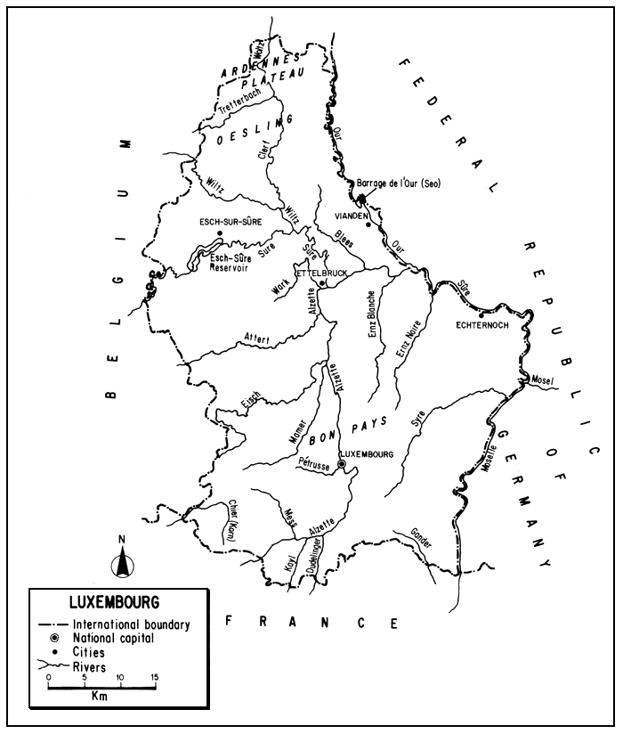
Luxembourg is situated at 49°26'52" and 50°10'58"N latitudes and 5°44'10" and 6°31'53"E longitudes in the heart of industrial western Europe.
Shaped like a shoe, its greatest length (N–S) is 82 km, its greatest width (E–W) is 56 km. Mostly over 250 m in elevation, its highest point is 558 m; its lowest point (the confluence of the Moselle and Sûre) is 130 m.
Luxembourg is bounded on the north and west by Belgium for 148 km, on the east by the Federal Republic of Germany for 135 km, and the south by France for 73 km1.
1 The lengths of these boundaries are taken from Grand-Duche de Luxembourg (1984)
The northern third of the country, the Oesling or Islex, is part of the Ardennes plateaux which has a mean elevation of 450 m. Composed largely of flat-topped or rounded eminences, it is deeply dissected by swift tributaries of the Sûre and Our. There is considerable moorland but most of the area is well wooded, with spruce and pine at higher elevations and oak, birch, hornbeam and beech at lower levels. Sparsely settled, the Ardennes has been partially cleared to support subsistence agriculture.
The lower two thirds of the country, the Bon Pays or Gutland, which averages 250 m in elevation, consists of low plateau and broad, though steep-sided cultivated valleys. Much of the forest has been removed; oak and beech are dominant trees.
Slates and quartzites prevail in the Ardenne which is deficient in calcium and phosphorus and rather infertile. In the Bon Pays, the underlying rocks are sandstones and limestones, and light fertile soils prevail. Alluvial deposits are found in all the river valleys with slight gradient.
4. CLIMATE
The climate is temperate, cool, rainy and mild - somewhat transitional between the maritime type of northwestern Europe and the semi-continental type toward the interior.
The mean annual temperature is 9°C. The mean summer temperature is about 16°C, the mean maximum is 23°C (in July). Winters average about 0°C with a mean minimum of -2°C (in January).
The average annual precipitation is about 760 mm (range, 620 mm in the Bon Pays to 1 020 mm in the Ardenne). In the south there are about 45 days of frost; in the Ardenne there is frost for 100 days and snow cover for 20 to 30 days. Fringing ice may appear along the Moselle at times.
5. HYDROGRAPHY AND LIMNOLOGY
Luxembourg's surface drainage forms a hydrographic entity in that the waters of all its rivers save one are ultimately discharged into the Moselle (Mosel) and thence to the Rhine. The exception is the Chiers (Korn), a small drainage in the south-west, which flows to the Meuse in France.
The approximate annual run-off is 300 mm or 1 000 million m3. Upstream countries contribute 4 000 million m3, so that the total annual river discharge leaving Luxembourg is 5 000 million m3 (Van der Leeden, 1975; ECE, 1978).
5.1 Rivers (Rivières)
Luxembourg has about 1 330 km of streams; 96 km are owned by the Government, 1 234 km are private. Table 1 lists the principal streams of the country.
The Sûre (Sauer) is considered to be the principal river of Luxembourg because of its length and its function as the major outlet of the country's drainage. From its origin in the Ardennes of Belgium, it flows east to the Belgian/Luxembourg border and follows the frontier for a short distance before winding tortuously in an easterly and then southerly direction for 160 km to its confluence with the Moselle. Before its junction with the Our (see below) it forms part of the Luxembourg/Germany boundary. The relative elevation and impermeable nature of the rocks in the Ardenne promotes a rapid runoff in its drainage from the north. The SOre's principal northern tributaries are the Wiltz and its affluent, the Clerf (Clervaux or Woltz) - both with headwaters in Belgium - which flows through deeply incised valleys. Other left-bank tributaries of the Sûre from the north are the torrential Blees and the larger Our River. The latter rises in Belgium and flows 80 km south (51 km in Luxembourg) to form Luxembourg's northeastern boundary with the Federal Republic of Germany for most of its course.
The Alzette is the Sûre's major right-bank or southern tributary, draining almost half of the Bon Pays. Arising in France, it flows north in Luxembourg for 60 km to its junction with the Sûre, fed en route from the left (west) by the Mess, Pétrusse, Mamer, Eisch, Attert and Wark, and from the right (south) by the Kayl and Dudelingerbach. Originating near the centre of the iron and steel industry, it has long been a heavily polluted stream.
Other tributaries of the lower Sûre from the south (right) are the Ernz Blanche (Weiss Ernz) and Ernz Noire (Schwarze Ernz).
The Moselle which flows northward between Luxembourg and the Federal Republic of Germany for 37 km, joined by the Syre (Syr) en route, leaves Luxembourg after its confluence with the Sûre to continue through Germany to the Rhine. With a low gradient and canalization, it is the country's only river for industrial transport.
All of the above streams are part of the Rhine drainage which ultimately reaches the North Sea. But in the extreme southwest of Luxembourg there is the Chiers (Korn) River which flows for 15 km in Luxembourg, passes into Belgium, and then France to join the Meuse (also North Sea drainage).
5.2 Lakes (Lacs)
There are no natural lakes in Luxembourg.
5.3 Reservoirs (Lacs artificiels or barrages)
Only one reservoir in Luxembourg has any great value for fishing, the 380-ha reservoir of Haute-Sûre (Esch-sur-Sûre), with a capacity of 60 million m3, completed on the upper Sûre in 1969 primarily as a source of drinking water. There are also the Bassin supêrieur (48 ha) and Bassin infêrieur (97 ha) of Vianden.
There are also about 120 ponds with a total surface area of about 45 ha owned privately or by communes (the units of local government). The most important of these are in Echternach and Weiswampach.
Table 1
Principal rivers of Luxembourg
| Name | Length in Luxembourg (km) | ||||
| Rhine (Rhin/Rhein) Drainage | |||||
| Moselle (Mosel) | 37 | ||||
| Gander (Altbach) | 17 | ||||
| Syre (Syr) | 30 | ||||
| Sûre (Sauer) | 160 | ||||
| Wiltz | 35 | ||||
Clerf (Woltz) | 45 | ||||
| Blees | 14 | ||||
| Our | 51 | ||||
| Ernz blanche (Weiss Ernz) | 30 | ||||
| Ernz noire (Schwarze Ernz) | 25 | ||||
| Altzette | 60 | ||||
| Mess | 11 | ||||
| Kayl | 7 | ||||
| Dudelingerbach | 7 | ||||
| Pétrusse | 11 | ||||
| Mamer | 25 | ||||
| Eisch | 28 | ||||
| Attert | 32 | ||||
| Wark | 19 | ||||
| Meuse (Maas) Drainage | |||||
| Chiers (Korn) | 15 | ||||
Source: Annuaire Statistique du Luxembourg, 1988/89
6. LAND AND WATER USE
Table 2
Pattern of land use in Luxembourg, 1980
| Percent | |
| Arable | 22 |
| Pasture | 27 |
| Forests | 32 |
| Built-on, “waste” | 19 |
| Total | 100 |
Source: Europa (1982)
Luxembourg is considered to be 83 percent urban and 17 percent rural.
A considerable portion of the land was cleared of forest long ago to provide charcoal for the iron industry and to permit the cultivation of crops. Facilitation of natural regeneration and afforestation are both practised today, and about one third of the land is carefully kept forest. Deciduous trees predominate, then conifers and brushwood.
Over half of the country is pasture and small mixed farmland with crops of cereals, potatoes, vines and emphasis on the rearing of livestock. Heavy fertilization, using phosphate products of the steel industry is common.
The country is also heavily industrialized giving it an economic significance quite disproportionate to its size. Coal resources are lacking, but Luxembourg does have iron mines and these and steel-making form the basis of the country's prosperity. Although exploitation of the iron mines has been slight since 1981, Luxembourg continues to make steel using imported ore. Luxembourg's steel mills are located in the south of the country near the iron mines. Other industries include banking, chemicals, brewing, tanning and textiles. Industrialization has been accompanied by a high degree of water pollution from both industrial as well as domestic wastes. Water pollution has been particularly severe in the Bon Pays' Alzette River drainage, which supports the heaviest population in the country. Population density is low in the Oesling and there are no really large cities.
Luxembourg has excellent aquifers and until recently has drawn much of its domestic water supply from underground sources in porous sandstone. Stored water from the Haute-Sûre reservoir will replace much of this.
The total installed electrical capacity in 1987 was 1 238 000 kW of which 1 132 000 kW (90 percent of the total) was hydroelectric.
The Moselle is canalized to allow barges up to 1 500 t and it and part of the Sûre are dredged for gravel. There are about 37 km of navigable inland waterways. All of the country was accessible by a dense rail (270 km) and highway (5 220 km) network in 1987. The road density was 2 km/km2 in 1982, and passenger car ownership very high, 443 per 1 000 persons (1978–79).
With attractive scenery (minor gorges, chateaux and vineyards), tourism (about 463 000 tourists in 1986) is an important industry and angling plays a part in its promotion.
7. FISH AND FISHERIES
The catch statistics in Table 3 are considered to represent a sport fishery, rather than the commercial fishery that is represented in most of the similar tables in this review. Possibly, some of the earlier figures represent a small commercial (or “subsistence”) effort, but information from Luxembourg/EIFAC (1977) states that the capture fishery is now “… considered essentially as a sport, there is no commercial fishery”. Worldmark (1984) modifies this statement by saying: “There is some commercial fishing for domestic consumption and much private fishing for sport”.
Table 3
Estimated sport catches in the inland waters of Luxembourg, 1938–751
(Species unspecified, in tons)
| 1938 | 500 |
| 1948 | 500 |
| 1955 | 300 |
| 1956 | 300 |
| 1957 | 300 |
| 1958 | 400 |
| 1959 | 300 |
| 1960 | 300 |
| 1961 | 400 |
| 1962 | 600 |
| 1963 | 600 |
| 1964 | 500 |
| 1965 | 500 |
| 1966 | 400 |
| 1967 | 400 |
| 1968 | 300 |
| 1969 | 300 |
| 1970 | 200 |
| 1971 | 200 |
| 1972 | 200 |
| 1973 | 200 |
| 1974 | 150 |
| 1975 | 150 |
Source: Luxembourg/EIFAC (1977)
7.1 Capture Fishery (Sport)
Species well represented in the fishery are brown trout (Salmo trutta), rainbow trout (Oncorhynchus mykiss), grayling (Thymallus thymallus), European eel (Anguilla anguilla), pike (Esox lucius), European perch (Perca fluviatilis) and a variety of cyprinids: common carp (Cyprinus carpio), bream (Abramis brama), barbel (Barbus barbus), nase or hotu (Chondrostoma nasus), chub (Leuciscus cephalus), roach or gardon (Rutilus rutilus) and tench (Tinca tinca).
The Moselle and Sure Rivers, the reservoir of Haute-Sûre, and many of the small trout brooks are primary fishing areas.
There were about 10 000 fishermen in Luxembourg (2.8 percent of the total population) in 1977. Fishing is a touristic as well as local attraction.
7.2 Aquaculture
Aquaculture in the sense of raising fish for direct consumption is not practised in Luxembourg.
The Government's station at Lintgen rears trout from eggs imported from Denmark, but these are stocked in open fishing waters. The number stocked per year has varied decidedly, but of late years larger trout are stocked, e.g., in 1986, 276 150 one-summer and 9 450 two-summer fish. Frontier waters are stocked with coarse fish, also imported mainly from Denmark and the reservoir of Haute-Sûre has been stocked.
Since 1950, stocking has concentrated on: trout, roach, tench, carp and pike. Other stocked fish include: grayling, bream, perch and pike-perch (Stizostedion lucioperca).
8. OWNERSHIP, ADMINISTRATION, MANAGEMENT, INVESTIGATION AND AGREEMENTS
8.1 Ownership
There are two major classes of fishing waters in Luxembourg:
Interior waters, including: (a) navigable streams and floatable waterways, for which the Government holds the fishing rights, and (b) non-navigable streams and floatable waterways whose fishing rights belong to the riparian landowners.
Frontier or boundary waters.
Licences to fish the non-navigable or non-floatable waters are awarded through public adjudication and the streams sub-divided under fishermen's organizations. Special licences are required on all the other waters.
8.2 Administration, Management and Investigation
The Ministry of Agriculture, Viticulture and Waters and Forests is responsible for the administration of inland fisheries in Luxembourg. Through its Directorate of Waters and Forests (Eaux et Forêts), it administers field services (e.g., fishery guards) in six forest cantons for forestry, hunting and fishing1. It also directs a Nature Conservation Service which includes a Hydrobiological Section devoted to: hydrobiological studies, pondfish culture, restocking and fish diseases.
There is also a High Council of Fisheries (Conseil Supérieur de la Pêche), a consultative body concerned with the conservation and protection of fisheries in cooperation with the Luxembourg Federation of Sport Fishermen.
1 Luxembourg is divided administratively into: 3 districts, 12 cantons, and 118 communes
8.3 International Agreements
Luxembourg is a member of the International Commission for the Protection of the Rhine against pollution together with France, the Federal Republic of Germany, the Netherlands, and Switzerland, as well as the European Economic Community (EEC).
9. STATE OF THE FISHERY
9.1 Yield
Reference to Table 3, with acknowledgement that its catch statistics are estimates, leads one to conclude that the overall catch of fish in Luxembourg is declining. Information from the Government (Luxembourg/EIFAC, 1977) substantiates the belief that the natural yield from the rivers is slowly but steadily diminishing and that continual restocking is necessary to support their fisheries.
9.2 Factors Affecting the Fishery
The relative absence of static water (no large lakes and no major possibilities for more large reservoirs) precludes the establishment of either commercial fisheries or great increase in recreational fisheries.
The reported decline in stream fishing is apparently to be ascribed to water pollution, especially that caused by domestic waste. Governmental statistics which compare the state of pollution in Luxembourg's waters in 1973 with that in 1977 are shown in Table 4. It will be noted that during this period, the length of water courses classed as having “no pollution” remained constant and the length of those waters with “strong pollution” declined almost one-third. However, the percentage of those waters with more intermediate pollution increased somewhat, and in 1977 it was considered that about one-third of the country's waters were so polluted that their fishery was affected adversely.
The annual runoff per caput of Luxembourg's streams based on the amount of water leaving the country amounts to a high figure (13 850 m3). This is, however, a misleading statistic since four fifths of this discharge leaving the country is derived from upstream countries and much of this flow is in peripheral or boundary streams. Based on the runoff originating only within Luxembourg, the annual runoff per caput is 2 700 m3. The Alzette basin, which drains most of southern Luxembourg, is particularly vulnerable, being highly polluted with domestic and industrial effluents.
Aside from the general deterioration of both water quality and quantity, there is a continual fishing pressure in this country where almost every water is easily accessible. On the positive side, most of the land is well tended, and pollution control is being aided through establishment of some important sewage treatment plants.
9.3 Prospect
The capture fishery, for recreation, will continue to be a small one. Its future rests upon resolution of the conflict - a basic one in such a small country - between the growth of population and industrialization and the preservation of amenities. The maintenance of good water resources to support recreational fisheries for both local anglers and tourists will aid in attainment of the latter goal.
Table 4
The degree of pollution in Luxembourg's water courses 1973–77
| Pollution index | 1973 | 1977 | |||
| km | percent | km | percent | ||
| None | 177.0 | 29.3 | 176.6 | 29.2 | |
| Weak | 296.7 | 49.1 | 322.3 | 53.3 | |
| Average | 71.6 | 11.8 | 85.1 | 14.1 | |
| Strong | 59.1 | 9.8 | 20.4 | 3.4 | |
| Total | 604.4 | 100.0 | 604.4 | 100.0 | |
Source: Modified from Table T.103 in Annuaire Statistique du Luxembourg 1982
10. REFERENCES SPECIFIC TO LUXEMBOURG
Edwards, K.C., 1967 Luxembourg: the survival of a small nation. Nottingham, University of Nottingham, 15 p.
Great Britain, 1944 Naval Intelligence Division, Luxembourg. Geographic Handbook Series, BR 528:355 p. (Restricted).
Luxembourg, 1982 Grand-Duche de Luxembourg, Ministere de l'Economie, Service Central de la Statistique et des Etudes Economiques, Annuaire statistique du Luxembourg 1982. Luxembourg, Service Central de la Statistique et des Etudes Economiques, 460 p.
Luxembourg, 1984 Annuaire statistique du Luxembourg 1983/84 Luxembourg, Service Central de la Statistique et des Etudes Economiques, 460 p.
Luxembourg, 1988 Annuaire statistique du Luxembourg 1988/89. 529 p.
Luxembourg, 1976 Programme directeur de l'amenagement general du territoire. Chapitre 6.1. La protection de la nature et la sylviculture. Luxembourg, Programme directeur de l'aménagement general du territoire.
Luxembourg/EIFAC, 1977 Information on inland water fisheries production in Luxembourg. (Response to the EIFAC Secretariat revising Dill, 1976). Unpublished
![]()
![]()
![]()