![]()
![]()
![]()
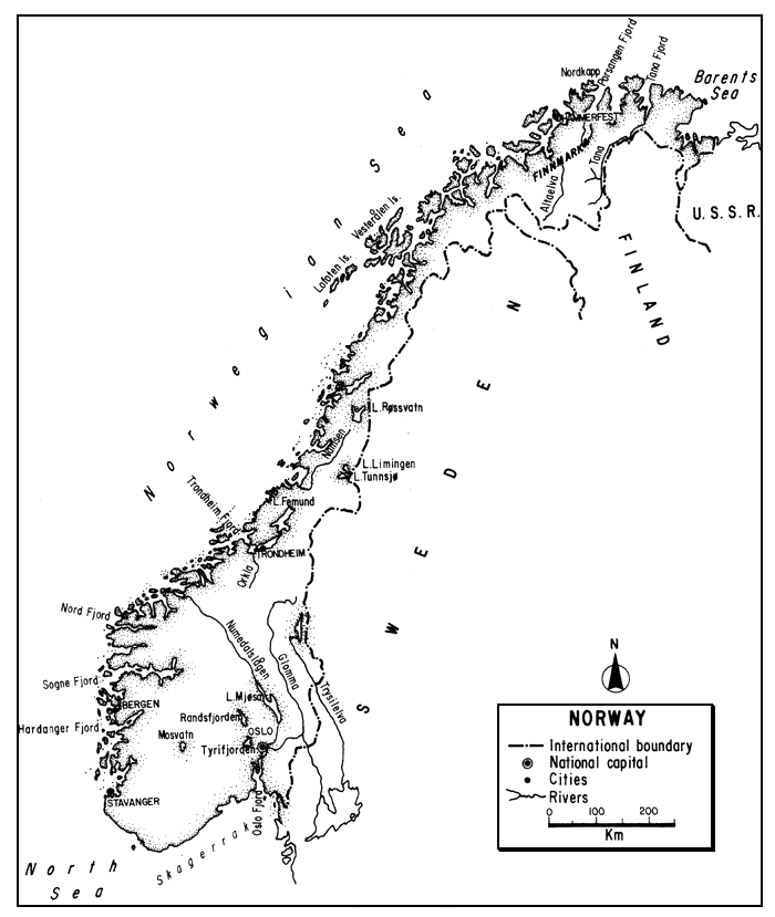
The Kingdom of Norway faces the Atlantic shore of the Scandinavian Peninsula, its extremely long coast sheltered by thousands of islets and indented by deep fjords. From the coast, the land rises abruptly to a series of high barren plateaux and ranges separated by a ridge from Sweden on the east. With one-third of its area above the Arctic Circle and elevations to almost 2 500 m, the terrain of Norway ranges from frozen tundra and glacial fields to forested river valleys in the south.
Poor agriculturally, its natural wealth lies in an abundance of water (hence hydroelectric resources), offshore gas and oil, timber and minerals. Industrially, it is a major shipbuilding and trading nation and has important marine fisheries.
Over five percent of the country is occupied by fresh waters, mainly short, swift rivers and about 300 000 lakes and tarns. Supporting good inland fisheries, especially for salmonids such as trout and chars, its Atlantic salmon fisheries have been famous both commercially and for sport for many years.
Low population density and relative inaccessibility protect many of its fisheries, but of late years, acid rains threaten many of its inland waters.
Aquaculture, especially of salmonids in sea water, is a fast growing industry.
| 1. | AREA: | 323 895 km21 |
| 2. | POPULATION: | 4 177 000 (est. 1990) | Density: 12.9 inh/km2 |
| 3. | PHYSICAL GEOGRAPHY | ||
Norway, situated in northwestern Europe, extends from 57°57'31" to 71°11'8"N latitudes and from 4°30'13" to 31°10'4"E longitudes. One third of the country is north of the Arctic Circle.
Occupying the western and northernmost portion of the Scandinavian Peninsula, its greatest length (N–S) is 1 752 km, its greatest breadth is 430 km and its narrowest 6.3 km. Its altitudinal range is from sea level to 2 469 m. Thirty percent of the mainland is below 300 m, the average height is about 500 m, and 20 percent is over 900 m.
Fronting on the Atlantic, Norway's sea boundaries are the Skaggerak on the south, the North Sea and the Norwegian Sea of the Atlantic on the west, and the Barents Sea of the Arctic Ocean on the north. With respect to land, it is bounded for most of its eastern length by Sweden for 1 619 km, and in the extreme northeast by Finland for 727 km and the USSR for 196 km2.
2 The lengths of these boundaries are taken from Statistik Sentralbyrå (1987)
The coast of Norway's mainland, mostly cliffbound, is extremely long. Disregarding bays and fjords it is 2 650 km in length; when these are taken into account it is 21 347 km. The coast is protected by extensive belts of low-lying islets or skerries. Of about 150 000 islets and large rocks constituting this system, estimated as having a coastline of 35 659 km, the Lofoten and Vesteralen groups are the largest components.
The Scandinavian Peninsula is a block of ancient granite and gneisses tilted slightly to the east. This results in a long eastern slope (across Sweden) toward the Baltic, and a shorter more precipitous western slope (across Norway) down to the Atlantic.
Thus, from most of Norway's narrow coast the surface rises precipitously to high plateaux and ranges, with a ridge following the boundary with Sweden. In the south, however, Norway includes both sides of the block as well as the broad upland between the slopes. The upland areas (fjells) which are generally bare of soil and vegetation are more like plateaux than rugged mountains.
Of several ways to describe Norway's physiographic regions, the simplest is to divide them into: (i) the coastal region, north of the Trondheim Fjord (64°N) - a narrow, mountainous fringe with islands and rocks often covered with snow; (ii) the western fjord region south of Trondheim; (iii) an interior lofty area of fjells or plateaux and lakes, and (iv) a southeastern lowland with valleys draining into the Oslo Fjord.
The western region is cut into long, narrow, deep, steep-sided fjords - old glaciated river valleys which are now fingers of salt water.
The fjells, generally composed of bare rocks, low pasture and bogs, also contain a variety of shallow, irregular lakes. The southeast lowland has more clays and sands, is partly forested, and supports most of the population.
With respect to vegetaton, there are five natural regions: (i) a treeless coast covered with grass and shrubs, (ii) deciduous forests (of which birch, aspen, and alder are the most important) to the east, (iii) coniferous forest mostly farther inland and to the north, (iv) dwarf birches and willows in the north and at higher altitudes, and (v) grasses, mosses and lichens in the coldest areas.
Most of the country is composed of a complex of ancient igneous and metamorphic rocks which has been severely glaciated to create cirques, aretes and U-shaped valleys. There has, however, been little deposition of glacial material and the soils are scanty or poor. The rock base is largely impervious and produces little ground water. Peat bogs are extensive. Norway still has about 1 700 glaciers, which with ice caps cover about 3 100 km2. The largest ice field is the 486-km2 Jostedalsbreen.
4. CLIMATE
For a country lying as far north as Norway, the climate is quite mild because of the North Atlantic drift of warm water and air. On the west coast the climate is marine temperate with cool summers, mild winters, high precipitation and a mean annual temperature of 7°C. To the east the climate is an inland type with warm summers, cold winters and less precipitation. Temperatures in July vary from about 10°C in the north, to 14°C at Bergen on the southwest coast, and a mean of 16°C at Oslo. The January mean is about 3°C above North Cape (the extreme north), 1°C at Bergen and falls to about -10°C in central Norway.
The precipitation averages about 1 450 mm annually, rather evenly distributed throughout the year with spring the driest season. Geographically, however, it is more variable. In the mountains of the southwest it reaches as much as 6 000 mm per year (the highest in Europe) but in the far north and lee of the mountains the precipitation including snow does not exceed 250–300 mm per year1.
Most of the country is covered with snow from December to March except along the coastal strip. On the high plateaux the snow may lie for ten months near permanent icecaps. The snowline is low everywhere, ranging from below 915 m in the extreme north to 1 525 m in the south.
The North Atlantic drift of warm saline water keeps the coast ice-free all year. (The salinity in most areas of the Norwegian Sea is close to 34.9 ppt and that of the North Sea, 34–35 ppt.) The fjords are not penetrated by cold water from the open sea and neither the fjords nor the streams near the coast generally freeze. There is, however, a long period of ice-cover on interior streams and lakes; e.g., on Lake Øvre Heimdalsvatn, at 1 090 m in southern Norway, there is an ice-cover from mid-October to mid-June.
The growing season, based on frost-free days, is about 125 days in parts of Finnmark, rising to 305 days in the extreme south. Based on the average period with temperatures above 3°C between spring and autumn, it is about as follows, proceeding from north to south: Finnmark - 150 days; Trondheim - 160 days; Bergen - 260 days; southwest coast - 300 days, and Oslo - 190 days.
The winter nights are very long but there is almost continuous daylight from May through July above the Arctic Circle. There are long periods of cloud cover over most of the country. The evaporative rate averages about 250 mm annually, decreasing to 100–150 mm in the far north.
5. HYDROGRAPHY AND LIMNOLOGY
Well supplied with rivers and lakes, recent estimates of the total area of inland water in the country centre around 5 percent of the total area of continental Norway. Key (1956) states that 4.6 percent consists of a freshwater surface, Columbia Lippincott (1966) states that it is 4.75 percent, Anon. (1969) states that Norway has a freshwater area of 15 646 km2 (4.8 percent), and the source for Table 4 that it is 16 360 km2 or 5 percent. It is obviously some figure above all these, since a more authentic estimate (Statistik Sentralbyrå, 1983) states that the area of Norway's freshwater lakes alone is 16 390 km2 or 5.06 percent of mainland Norway.1
The approximate annual runoff from rainfall is 1 250 mm or 405 000 million m3. Upstream countries contribute 8 000 million m3 so the total annual river discharge leaving Norway is 413 000 million m3 (Van der Leeden, 1975; ECE, 1978).
With the Scandinavian Peninsula tilted generally to the southeast, a ridge-like area (in part) called the Kjølen or keel separates the long slow rivers flowing across Sweden from the generally short rapid western rivers of Norway.
5.1 Rivers (Vassdrag)
Norway has about 1 000 main rivers. The longest of these are listed in Table 1.
Table 1
Longest rivers and largest lakes in Norway
| Rivers | km | Lakesa | km2 |
| Glomma | 598 | Mjøsa | 368 |
| Tana (with Anarjokka) | 360 | Femund | 210 |
| Numedalslågen | 337 | Røsvatn | 201 |
| Dramsvassdraget | 309 | Randsfjorden | 145 |
| Skienvassdraget | 244 | Tyrifjorden | 136 |
| Otra | 242 | Snåsavatn | 118 |
| Namsen | 210 | Tunnsjø | 99 |
| Arendalsvassdraget | 209 | Limingen | 96 |
| Altaelva | 200 | Øyeren | 87 |
Gudbrandsdalågen (above Mjøsa) | 199 | Nisser | 77 |
| Mosvatn | 74 | ||
| Orkla | 179 | Iesjavri | 68 |
| Vefsna | 160 | ||
| Trysilelva (to border) | 132 |
a Areas of regulated lakes refer to highest regulated water level
Source: Statistisk Sentralbyrå (1987) for all lengths and all areas except those for Mosvatn and Iesjavri which are taken from Statistisk Sentralbyra (1983)
Most of the rivers have small catchment areas (rarely more than 3 000 km2), are short and swift, and drain westerly. Western streams generally run between steeply sloping walls (often in gorges 600 m deep), precipitously from the mountains to the valley and then rapidly to their mouths. The many waterfalls, especially on the shorter faster western streams are spectacular sights, but block the ascent of anadromous fish. Only in the southeast and north are the rivers of any length.
Southern and southeastern streams usually run rapidly from the mountains and rapidly down their valley except where - as is frequent - they are interspersed with lakes. Deep and sluggish rivers do not exist. Arctic Ocean rivers have gentle gradients, some rapids, but no important falls.
In the southeast there are several rivers more than 200 km in length. One of these is the Trysilelva which runs into Sweden where it is known as the Klarälven. Its total length is 652 km of which 132 km is in Norway. The country's principal river, however, is the Glomma. Rising at about 700 m near the Trondheim Fjord, it flows south to the Oslo Fjord and thus drains into the Skaggerak. With a catchment area of 41 000 km2, it has an average flow of 704 m3/sec and a length of 598 km (see Table 2). Another long river in this area is the Numedalslågen; rising in south central Norway, it runs for 337 km to the Skaggerak.
Table 2
Discharge of the Glomma River at Langnes, Norway (1930–40 and 1945–65)
| Mean monthly discharge, m3/s | |||
| January | 209 | Six-monthly average | |
| February | 158 | ||
| March | 178 | October–March | 331 |
| April | 526 | April–September | 1 078 |
| May | 1 677 | ||
| June | 1 476 | Yearly average | 704 |
| July | 1 126 | ||
| August | 874 | Mean annual runoff 1/s/km2 | 17.5 |
| September | 787 | ||
| October | 652 | ||
| November | 447 | ||
| December | 314 | ||
Source: Van der Leeden (1975) after ECE (1970)
There are also two large rivers draining most of the north. One of these, the Altaelva, rises on the Finnish border and flows north for 200 km to the Alta Fjord on the Barents Sea. The other, the Tana (Tenojoki in Finnish) on the border of Norway and Finland, flows northeast for 360 km to the Tana Fjord of the Barents Sea.
Stream flows are generally high with respect to the area drained. For 38 rivers each draining more than 1 000 km2 and representing in all little more than half the country, the average total discharge is no less than 4 000 m3/sec. Owing to impervious terrain and steep slopes, runoff is rapid and variations in flow enormous. It is sometimes between 1 and 3 000 percent of the average. In the lake and reservoir areas, the flows are, of course, equalized to some extent. During the winter, many of the rivers freeze in their upper courses and rise rapidly during maximum rainfall and spring thaw to cause flooding unless they are controlled by lakes.
Most of the rivers have their maximum discharge in spring and the minimum in summer and late winter due to the precipitation regime and snow storage in winter. In the north there may be, however, two or even three discharge maxima due to snow melt in the forest regions (“home flood”) and later due to the melting of snow and glaciers in the highest mountains (“mountain flood”) western Norway, the large amount of precipitation during the year keeps a comparatively even discharge but there are still maxima.
5.2 Lakes (Innsjøer or Sjøer)
There are about 300 000 natural lakes and tarns in Norway, totalling about 16 390 km2.
There are some cirque lakes in the high mountains and many irregularly shaped lakes on the undulating surfaces of the high plateaux. All of the large Norwegian lakes, such as Mjøsa and Tyrifjorden, owe existence mainly to glacial overdeepening of valleys. Lakes are most numerous in the southeast, strung out along the river valleys. Most of the river valley lakes of Norway are only expansions of the rivers and possess strong currents. Most of the lakes are long and narrow and of little area but of great depth. Norway has 35 lakes over 100 m deep, and many give soundings showing beds well below that of present sea level. Hornindalsvatn, for example, at an altitude of 55 m has a depth of 459 m below sea level.
In many cases, the low-lying lake near the head of a fjord is separated from sea water by a narrow neck of land which on further land subsidence would resemble the submerged sill characteristic of the underwater topography of the fjords (see section 5.4).
The lakes in the north and high interior freeze for varying periods each year, e.g., Djupvand at 975 m is often frozen throughout the year, and Haugatjern at 697 m in central Norway may be icecovered for 200 days. In the south, however, where the majority of the large lakes are situated, they become icebound only during severe winters.
The 12 largest Norwegian lakes are listed in Table 1, and some characteristics of the major ones are shown in Table 3. Of these lakes, Mjøsa, which has a retention time of six years, is the largest lake in Norway, and Hornindalsvatn the deepest lake in Europe and ninth deepest in the world.
Table 3
Some characteristics of seven major Norwegian lakes
| Altitude m | Area km2 | Mean depth m | Max. depth m | Length km | Width km | Volume km3 | |
| Mjøsa | 121 | 368 | 153 | 449 | 105 | 1.6–14.5 | 56 |
| Femund | 662 | 201 | - | 130 | 67.6 | 1.6–11.0 | 6.0 |
| Tyrifjorden | 63 | 136 | - | 295 | - | - | - |
| Mosvatn | - | 74 | - | 45 | 40.2 | 1.6–7.8 | - |
| Hornindalsvatn | 55 | 51.8 | - | 514 | 26 | - | - |
| Tunnsjø | 184 | 99 | - | 429 | - | - | - |
| Bydgin | 1 063 | 45.3 | - | 215 | - | - | - |
Sources: Encyclopaedia Britannica (1937), Myklebost and Strømme (1963), Columbia-Lippincott (1966), USSR (1978), Holtan (1978), Statistisk Sentralbyra (1982), Seip (1981)
5.3 Reservoirs (Vannreservoar)
Concrete dams of considerable size were started very early in Norway, one being built in 1890 and two others in 1915 and 1916. Data furnished to Van der Leeden (1975) list 11 major reservoirs in Norway as of 1973, with individual storage capacities ranging from 0.41 to 2.36 billion m3 to total 10.43 billion m3 and two others planned to hold 4.76 billion m3. It is clear from the data, however, that at least some of these are natural lakes (e.g., Mjøsa). In Norway, many natural lakes (perhaps half of its lake area) have been impounded to provide and equalize water flow for hydroelectric production. The distinction between “reservoirs” and “lakes” is not as clear-cut as in some of the other (drier) European countries, but it is obvious that comparatively few impoundments have been constructed where the natural flows are low. They are concentrated where cheapest to construct, and are interconnected as part of a system.
5.4 Fjords
The fjords of Norway deserve special mention here because although they are now actually arms of the sea, they run far inland. Partially submerged glacial troughs, they are typically long, straight and narrow, with steep parallel sides and side arms and a shallow sill or threshold at the mouth1. With shallow water at their mouths (sills range in depth from a few metres to 100–200 m), they may be extremely deep farther inland. Most fjords do not exceed 600 m in depth, but the Hardanger Fjord has a depth of 884 m, and the Sogne Fjord has a maximum depth of almost 1 300 m.
1 Some fjords in northeastern Norway lack sills
Fjords represent a balance between two layers of water: salt water of high density and salinity and the lighter fresh water from the land. The layering is most pronounced during the summer. Some fjords present special problems with respect to pollution in the deep water above (i.e., upstream of) the lower shallow section, which is subject to little change. The salt water mixes but little with the fresh water from the rivers floating above and out to sea. Effluents which sink to the bottom remain there, decaying and setting up anaerobic conditions.
The fjords provide migration paths for anadromous fishes and provide a variety of fishing.
The longest fjords in Norway are the: Sogne (204 km), Hardanger (179 km), Trondheim (126 km), Porsanger (123 km), Nord (106 km) and Oslo (100 km). Other well known fjords are the Ofoten, Lyngen and Varanger.
5.5 Canals (Kanal)
Although there are some canalized rivers - mostly connecting lakes - especially constructed canals are unimportant in Norway. Hard winters discourage their use. There are three principal canals, of which the largest is 104 km, used mostly for floating logs and by tourists.
6. LAND AND WATER USE
Table 4
Pattern of land use in Norway, 1986
| Percent | |
| Arable and permanent crops | 2.6 |
| Permanent pasture | 0.3 |
| Forests and woodland | 25.7 |
| Other land (mostly mountains, snow and ice) | 66.4 |
| Inland water | 5.0 |
| Total | 100.0 |
Source: 1987 FAO Prod.Yearb., 41, Publ. 1988
Norway is now about 75 percent urban and 25 percent rural. It derives about 70 percent of its income from industry and mining, construction, commerce and sea transport - thus minimizing its direct use of land and water.
With fertile zones constituting only about four percent of the total area, agriculture, on small holdings, is obviously a minor use of land (less than three percent). Dairying and production of livestock, hardy grains, hay, potatoes and some fruit are its principal activities. Steep slopes, heavy precipitation (and the presence of a thriving chemical industry) promote the substantial use of fertilizers, almost twice the European average. Their use as well as the discharge of effluents from industries associated with agriculture have adversely affected a number of inland waters. There is a little supplemental irrigation in some areas, about 92 000 ha (0.28 percent) of the country received irrigation in 1986. Most of this is sprinkler irrigation and some sewage water is used for this purpose.
With conifers (four-fifths Scots pine, the rest mainly spruce) covering one-quarter of the country, forestry is important, especially for the pulp and paper industry and as an export source. The total production of about 11.4 million m3 of roundwood in 1985 is however still relatively low, ranking only eleventh in European national productivity. Felling does not exceed the rate of growth and there is considerable reforestation. One of the principal uses of Norwegian rivers is log floatation, which started on the Glomma in 1200 A.D. Thirty to forty million logs have been floated annually during spring and summer months, sometimes with adverse effects on fisheries. A great deal of water is needed in the pulp industry, about 1 000 t for one ton of pulp. The forest processing industry is also a source of water pollution.
Mining is restricted to a few minerals, primarily iron pyrites (a source of pollution), copper, zinc, ilemite and molybdenum1. The production of offshore oil and gas is highly important in Norway today, but has little effect on inland fisheries.
1 Some coal is imported from Svalbard
Industry, which is increasing in importance, is rather concentrated, especially in the Oslo region, near large ports or near hydroelectric plants. Food, fish, forest products (especially pulp and paper), aluminium, using imported ores, ferro-alloys, electro-chemistry and electro-metallurgy are important industries as is shipbuilding. Great demands on water and hydroelectric power are made by some of these industries and pollution also stems from their activities. New industries are, however, encouraged to locate in the areas least sensitive to pollution, e.g., along the coast. For a discussion of Norway's very serious pollution from acid rain, see Section 9.2.
Offsetting the lack of coal and (until lately) oil, Norway is admirably situated for the production of hydroelectric power. Precipitation is ample and well distributed, the evaporative rate is low, winters on the coast are mild so that the streams do not freeze, there are great drops or falls to create a high head, the relatively impermeable rock makes unlined tunnels possible, and there are many lakes on the high plateaux for natural storage. Low head power is also produced on a few rivers with catchments large enough to produce sufficient volume. In 1985 there were 625 hydroelectric power stations in Norway. In 1989, the installed electrical capacity in Norway was 23 236 000 kW of which 22 991 000 (99 percent) was hydroelectric and the rest thermal. With much of the country's lake area regulated to develop electricity, 31 700 million m3 of water were developed by 1966, and it is estimated that the total effective storage that can be constructed is 75 000 million m3.
The terrain and climate in Norway make transport by either road or rail (about 4 275 km) difficult. Thus, although automobile ownership (381 per 1 000 persons in 1986) is fairly high, road development is among the lowest in Europe, only 0.26 km/km2 in 1986. Consequently, large areas are left relatively untouched by a population three quarters of whom live within 20 km of the sea. There are about 1 600 km of inland waterways (1980) and water transport along the coast, on the fjords, and on some of the larger lakes (the rivers are seldom navigable) causes some pollution.
For many years, Norway has been one of the world's most important marine fishing nations. Although fisheries have lately constituted less than two percent of the GNP, the export value of fish and fishery products amounts to over 10 percent of the merchandise exports. Domestic consumption of fish for food is high, about 40 kg per caput per year (1987), accounting for over 10 percent of the nation's protein supply. Sport and household fishing are important in Norway's lakes and rivers which also have limited commercial fishing.
With respect to total water use in Norway, it was estimated in 1972 (by the Norwegian Water Resources and Electricity Board) that a total of 1 430 million m3 of water was used as follows: industry 84 percent, municipal supply 14 percent, and agriculture 2 percent. Most of the domestic water supply is obtained from surface sources, there being little ground water available, but treatment is relatively rare. Sewerage is increasing, and a national programme called for all of the population to be served by sewage treatment facilities by 1990.
7. FISH AND FISHERIES
Like its neighbour, Sweden, Norway has a limited freshwater fish fauna - there are about 30 species - dominated by salmonoid fishes. In Norwegian lakes, the brown trout (Salmo trutta) is the commonest species and in tens of thousands of these lakes it is the single species present (Jensen, 1977). According to Aass (1984) the brown trout populations in Norway, especially in the high-lying forest and mountain regions are mainly the result of introductions going back to the Stone Age and continued today. Other important fishes include the Atlantic salmon (Salmo salar), sea trout (S. trutta), char (Salvelinus alpinus), various coregonids (Coregonus spp.), grayling (Thymallus thymallus), European perch (Perca fluviatilis), pike (Esox lucius), burbot (Lota lota) and the European eel (Anguilla anguilla). Crayfish (Astacus astacus) are also taken, but their numbers have been affected by the crayfish plague, (Aphanomyces astaci) first noted in Norway in 1981.
7.1 Capture Fisheries
Although the brown trout is its commonest species, it is the anadromous Atlantic salmon which has made sport fishing in Norway world famous1. Norway has more salmon rivers than any other country; they include about 150 listed streams of which about 50 are suitable for sport fishing, and 75 percent of the rod catches are made in 10 rivers. Until recently, these waters have been extremely productive and their fish have been of large size. The world record Atlantic salmon taken by angling is a 36-kg fish from the Tana River and the world fly record, a 31-kg fish from the Arøy. The salmon run up the rivers mainly from the end of May through September. As has been indicated, the Norwegian salmon caught by angling are exceptionally large. Some Norwegian rivers also have fine runs of sea trout (Salmo trutta). Sea trout generally enter the rivers sometime later than do salmon, say from mid-July and continuing through September. The combined catch of these two species in the top Norwegian rivers in 1976 and 1986 is shown in Table 5.
Table 5
Catch of Atlantic salmon and see trout in the highest yielding Norwegian rivers (i.e., above 5 t in either year), 1976 and 1986 (in tons)a
| 1976 | 1986 | |
| Tanavassdraget | 164.5 | 67.9 |
| Lågen (Numedalslågen) | 28.1 | 24.6 |
| Altavassdraget | 22.2 | 14.4 |
| Namsenvassdraget | 18.9 | 11.7 |
| Gaulavassdraget | 16.7 | 24.2 |
| Bondalselva | 15.6 | 2.6 |
| Driva (Sunndalselva) | 11.6 | 5.7 |
| Stjørdalsvassdraget | 9.3 | 8.9 |
| Neidenelva | 9.2 | 9.4 |
| Komagelva | 7.8 | 1.7 |
| Orkla | 7.6 | 12.1 |
Stordalselva m/ Stordalsvatnet (i Åfjord) | 7.5 | 5.4 |
| Vefsna | 7.2 | 2.5 |
| Ørstaelva | 6.4 | 2.1 |
| Laerdalselva | 6.3 | 6.7 |
| Surna m/ Rinna | 6.1 | 3.6 |
| Rauma | 5.3 | 1.0 |
Straumgjerdeelva m/ Velledalselva og Fetvatnet | 5.2 | 1.6 |
| Ogna | - | 8.7 |
| Håelva | - | 8.1 |
| Figgjoelva | - | 7.2 |
| Drammenselva | - | 6.8 |
| Målselvvassdraget | 4.1 | 5.5 |
Source: Statistisk Sentralbyrå (1978, 1987) from NOS Lakse-og sjøaurefiske
Schwiebert (1975) states that the total catch of salmon spawned in Norwegian rivers was about 1 000 t each season in the first half of this century, with 85 percent taken in salt water commercial nets and traps or by trolling lines. The other 15 percent was taken in rivers mostly with sport fishing equipment but also with nets and traps. He further states that after mid-century, the annual catch in Norwegian waters doubled to about 2 000 t and continued at this rate for almost 20 years. The annual catch then dropped to about 1 000 t. He ascribes almost all of this decline to commercial fishing with drift nets and longlines (capturing 50 percent of the commercial catch) and simple bag nets for the other 50 percent. He says that there were only 100 bag nets in Norway a century ago, but that their number was almost 10 000 at the close of the nineteenth century and has ranged from 5 000 to 8 000 in this century.
Although net fishing is not permitted in the estuaries, it is allowed in the rivers where the fishing rights belong to the owner of the nearest shore. Set bag nets are the principal gear. Although commercial fishing with drift nets and longlines has been banned within the 12-mile limit, it is common farther offshore and bag netting in shallow waters continues.
Further to the fishing strain on Atlantic salmon, Berg (1977a) states that: “In Norway, the fishery in the sea takes such a large proportion of the salmon returning for spawning in their home river that in some rivers only the smallest possible number necessary to maintain a stock is left”. Some steps have been taken since then to tighten the regulations on the catch of Atlantic salmon, and therefore, it is hoped, to increase the stocks in rivers, especially for anglers. Thus, in 1986 and again in 1988, the Norwegian Storting (Parliament) passed legislation placing a ban on drift nets, the use of monofilament for nets, the use of longline fishing, and prawn and worm fishing in Norwegian rivers, as well as restrictions on the riparian use of nets in rivers.
Catch statistics furnished by Norway with respect to Atlantic salmon, “trout” and another diadromous fish, the European eel (Anguilla anguilla) caught in marine waters by Norway are available in the FAO Yearbooks of Fishery Statistics (see Table 6). Comparison of the figures for Atlantic salmon in this table with those given above by Schwiebert (1975) seem roughly comparable.
Although Norway collects and publishes statistics on the catch of salmon and sea trout in its inland waters, the FAO Yearbooks of Fishery Statistics did not publish them until the advent of its Volume 52, which did list some of the inland fishery catches in Norway during the period 1978–811. Thus, reference to the earlier volumes give one a misleading picture of this catch which is so important in Norway. Reference to the FAO Fisheries Department's Fishery Statistical Database (FISHDAB) will, however, provide “catch” figures in Norway's inland waters for Atlantic salmon and rainbow trout (Oncorhynchus mykiss) from 1970 onwards. These are reproduced here in Table 7. It seems quite clear, however, that they represent both actual catches (capture fishery) and the products of aquaculture. Simply compare these figures with those published directly by Norway (Tables 8 and 10) or sent directly to EIFAC by Norway (Table 9). With respect to Atlantic salmon, one example using 1975 statistics should suffice. The actual catch in Norwegian rivers for that year was 505 t (Table 9). If one adds this catch to the 862 t of salmon reared aquaculturally in Norway in that year (Table 10), one arrives at the sum of 1 367 t shown in Table 7 based on FAO data. In other later cases it appears that most, if not all, of the entire “catch” of salmon represented in Table 7 is actually aquacultural production. Note the close coincidence of figures in Tables 7 and 10; for example, the 17 604 t reported caught in 1983 (Table 7) with the 17 298 t reported as reared in 1983 (Table 10). Reference to these tables will also show that all of the rainbow trout listed in Table 7 are cultivated fish.
It is best, therefore, to use Table 8 for catch records of salmon and sea trout by Norway in the country as a whole and in the rivers during the 1958–86 period. A breakdown showing the species composition of these catches in the rivers alone during the 1969–75 period appears in Table 9.
Table 6
Nominal catches of diadromous species in Marine Statistical Fishing Area 27 -Northeast Atlantic, by Norway, 1965–87 (in tons)a
| European eel | Atlantic salmon | Rainbow trout | Trouts n.e.i.b | |
| 1965 | 500 | 1 700 | - | - |
| 1966 | 500 | 1 600 | - | - |
| 1967 | 500 | 1 700 | - | - |
| 1968 | 600 | 1 400 | - | - |
| 1969 | 500 | 1 300 | - | - |
| 1970 | 400 | 1 000 | - | - |
| 1971 | 400 | 1 200 | - | - |
| 1972 | 400 | 1 700 | - | - |
| 1973 | 400 | 1 700 | - | - |
| 1974 | 383 | 1 400 | - | - |
| 1975 | 411 | 1 280 | - | - |
| 1976 | 368 | 1 099 | - | - |
| 1977 | 352 | 1 184 | - | 0 |
| 1978 | 347 | 817 | - | 0 |
| 1979 | 374 | 1 528 | - | 0 |
| 1980 | 387 | 1 563 | - | 0 |
| 1981 | 369 | 1 379 | - | 1 |
| 1982 | 385 | 1 087 | - | 1 |
| 1983 | 317 | 1 270 | - | 1 |
| 1984 | 309 | 23 236 | 3 569 | 5 |
| 1985 | 352 | 30 796 | 5 237 | 3 |
| 1986 | 271 | 46 142 | 4 384 | 0 |
| 1987 | 283 | 48 473 | 8 787 | 1 |
0 Probably nil, negligible or insignificant or less than half a ton
Source: 1965–69 Yearb.Fish.Stat.FAO, 36 (Publ. 1974)
1970–83 FAO Fish.Dept.Fishery Statistical Database (FISHDAB)
1984–87 Yearb.Fish.Stat.FAO, 64 (Publ. 1989)
It will be noted in Table 9 that the reported catch of sea trout each year is quite consistent but that there has been a remarkable rise in the reported harvest of salmon during the 1973–75 period. According to Norway/EIFAC (1977), a substantial part of this rise was caused by a better “control” of fishing in the Tana River (Tanavassdraget) in Finnmark which had produced an apparent increase in yield from a “bottom” of 7 865 kg in 1971 to 184 327 kg in 1975. The dominance of the Tana catch in 1976 is shown in Table 5: it constituted almost one-third of the country's entire river catch of slamon and sea trout. However, the Tana River catch in 1986 - although still leading the country - had fallen to only 40 percent of its 1976 catch, and 18 percent of the entire river catch. Large swings in the harvest from other Norwegian slamon and sea trout rivers will also be noted.
It was noted above that the catch of European eel in Norway's marine waters is shown in Table 6. According to Gundersen (1979), the eel fishery in Norway is a small one. Most of the fishing takes place in the sea and these are the only catches included in Norwegian statistics although fishable stocks also occur in fresh waters. From 1920 to 1933, the landings increased from 80 t to about 700 t, and then declined to about 400 t in 1939. Since then, the highest catch has been 600 t in 1968, the lowest 102 t in 1945.
Table 7
Nominal catches by species in the inland waters of Norway, 1965–87 (in tons)a
| Atlantic salmon | Rainbow trout | Total | |
| 1965 | ... | - | |
| 1966 | ... | - | |
| 1967 | ... | - | |
| 1968 | ... | - | |
| 1969 | ... | - | |
| 1970 | 200 | 0 | 200 |
| 1971 | 300 | 400 | 700 |
| 1972 | 400 | 800 | 1 200 |
| 1973 | 600 | 1 000 | 1 600 |
| 1974 | 1 089 | 1 726 | 2 815 |
| 1975 | 1 367 | 1 655 | 3 022 |
| 1976 | 1 899 | 2 045 | 3 944 |
| 1977 | 2 472 | 1 795 | 4 267 |
| 1978 | 3 805 | 2 105 | 5 910 |
| 1979 | 4 717 | 2 988 | 7 705 |
| 1980 | 4 607 | 3 668 | 8 275 |
| 1981 | 8 716 | 4 624 | 13 340 |
| 1982 | 10 984 | 4 627 | 15 611 |
| 1983 | 17 604 | 5 405 | 23 009 |
| 1984 | 352 | - | 352 |
| 1985 | 381 | - | 381 |
| 1986 | 363 | - | 363 |
| 1987 | 425 | - | 425 |
a The catches are obviously incorrect especially from 1984 through 1987. See text
... Data not available according to source; - Not listed in source
0 Probably nil, negligible, or insignificant; or less than 50 t
Source: 1965–69 Yearb.Fish.Stat.FAO, (36) (Publ. 1974)
1970–83 FAO Fish. Dept. Fishery Statistical Database (FISHDAB)
1984–87 Yearb.Fish.Stat.FAO, (64) (Publ. 1989)
The yield of crayfish has been estimated at 109 000 to 188 000 individuals per year (Jonsson, 1988)
It is obviously difficult to estimate the total catch of either anadromous or resident fish in Norway's inland waters. Not only is it difficult to secure accurate figures on even a single body of water (the Altaelva, for example, has about 300 landholders along the river) but virtually impossible to collect information on catch in the thousands of small water bodies in the country. Some estimates are, of course, made; thus MacCrimmon and Gots (1980) estimate that 650–1 000 t of resident char are caught annually. However, total catch statistics for strictly “inland” fish (i.e., nonanadromous fishes such as brown trout, char, pike and perch) are not available from any source.
Some indication of the magnitude of this inland catch may, nevertheless, be derived from some estimates based on the assumed catch per unit area of Norway's lakes. (The bulk of the “inland” catch is made in lakes and is primarily of trout.) In 1962 it was estimated that the annual yield per hectare from Norway's lakes averaged about 1.5–2 kg. Based on an estimated that lake area of about 15 000 km2, the total inland catch (exclusive of sea-run fish) was then estimated at about 2 000–3 000 t (EIFAC, 1964). At a later date the average annual yield/ha of lake surface was reestimated at 2–4 kg/ha, providing a new estimate of total catch in Norway's lakes of 3 000–6 000 t (Norway/EIFAC, 1974, 1977), and in 1980 the total yield of Norway's inland fisheries was estimated to be in the order of 5 000 t (Swang, 1981).
Table 8
Catch of Atlantic salmon and sea trout in Norway, 1958–86
| in tonsa | Value in NKr '000 | |||
| Year | River catch | Total catch | River catch | Total catch |
| 1958 | 251 | 1 490 | 2 624 | 16 835 |
| 1959 | 209 | 1 404 | 2 240 | 16 006 |
| 1960 | 237 | 1 659 | 2 804 | 19 808 |
| 1961 | 198 | 1 533 | 2 395 | 19 236 |
| 1962 | 264 | 1 935 | 3 304 | 24 816 |
| 1963 | 233 | 1 786 | 2 818 | 22 138 |
| 1964 | 320 | 2 147 | 4 223 | 30 070 |
| 1965 | 294 | 2 000 | 3 607 | 24 816 |
| 1966 | 269 | 1 863 | 3 799 | 28 206 |
| 1967 | 361 | 2 052 | 5 095 | 31 877 |
| 1968 | 275 | 1 593 | 3 705 | 20 949 |
| 1969 | 220 | 1 466 | 3 058 | 25 523 |
| 1970 | 235 | 1 251 | 3 287 | 20 964 |
| 1971 | 266 | 1 288 | 4 375 | 23 027 |
| 1972 | 294 | 1 653 | 5 860 | 35 901 |
| 1973 | 449 | 1 806 | 7 807 | 33 674 |
| 1974 | 532 | 1 702 | 8 008 | 26 483 |
| 1975 | 553 | 1 611 | 9 560 | 28 052 |
| 1976 | 514 | 1 597 | 13 106 | 41 927 |
| 1977 | 381 | 1 560 | 10 514 | 44 048 |
| 1978 | 307 | 1 117 | 7 841 | 28 651 |
| 1979 | 376 | 1 896 | 10 811 | 59 985 |
| 1980 | 341 | 1 892 | 11 318 | 71 332 |
| 1981 | 341 | 1 713 | 10 384 | 48 742 |
| 1982 | 338 | 1 416 | 10 692 | 46 718 |
| 1983 | 360 | 1 626 | 11 874 | 54 370 |
| 1984 | 356 | 1 698 | 12 541 | 58 902 |
| 1985 | 388 | 1 646 | 14 329 | 62 124 |
| 1986 | 373 | 1 684 | 13 699 | 59 446 |
Source: Statistisk Sentralbyrå (1978, 1987) from NOS Lakse-og sjøaurefiske
Table 9
Catch of Atlantic salmon and sea trout in Norwegian rivers, 1969–75 (in kg)
| Year | Salmon | Sea trout | Total |
| 1969 | 178 280 | 41 413 | 219 693 |
| 1970 | 187 549 | 47 163 | 234 712 |
| 1971 | 221 655 | 44 507 | 266 162 |
| 1972 | 241 338 | 52 771 | 294 109 |
| 1973 | 400 595 | 48 500 | 449 095 |
| 1974 | 487 546 | 44 123 | 531 669 |
| 1975 | 505 420 | 47 922 | 553 342 |
Source: Norway/EIFAC (1977)
With respect to fishing methods, salmon fishing has been described above. Fishing for anadromous chars is carried on mainly in the river mouths when the fish return in late summer or early autumn. Commercial fishing in lakes is primarily with traps and gillnets. Fishing continues winter and summer. Brown trout are caught under ice but the main salmonid taken under ice is char.
It should be noted that the mere weight of fish caught in Norway is not a true indication of the value of the resource. The cost of rental rights to fish some of Norway's finest salmon streams is staggering (e.g., as long ago as 1969, the Laerdal rented for U.S.$ 83 000 and the Driva for U.S.$ 63 750 and circa 1966 one month on the Altaelva cost U.S.$ 28 000). The average weight of rod-caught salmon early in the season on the Altaelva is about 11 kg, and only 10 rods are allowed on the upper 40 km in late June, early July. Each rod will then pay about US$ 6 500/week. In 1988, the following prices for a rod/week of Atlantic salmon fishing in Norway were quoted by Frontiers (1988): US$ 4 490 on the Orkla; US$ 4 800 on the Laerdal (Oye Beat), and US$ 5 900 on the Gaulafoss Pool. According to official statistics, the total income from lease of Norway's salmon streams in 1975 was a little less than U.S.$ one million, but there are good indications that unreported and current returns would make this a much higher figure1.
In 1973, records of fishing licence sales in Norway indicated that there were about 242 000 sport fishermen or 6.4 percent of the population. However, a survey made in 1970 by the Central Board of Statistics showed that 34 percent of the Norwegian population in age-group 15–74 years had been fishing in the year September 1969–August 1970. If true then 900 000 people should have been sport fishing in Norway's inland waters (Norway/EIFAC, 1977)2. The estimate of 900 000 Norwegian anglers agrees with that of Anon. (Norway) (1980). Such a figure would represent closer to 20 percent of the total population at the time. Actual license sales in 1988 were 253 421 (Norway/EIFAC, 1989).
7.2 Aquaculture
The water temperature in Norway limits aquaculture to cold water species such as trout and salmon. The climatic conditions, however, are not very suitable for “Danish-style” trout farming, i.e., raising rainbow trout (Oncorhynchus mykiss) in freshwater ponds to portion size of 150–250 g. Even in southern Norway, most fresh waters have temperatures well below 4°C and often approach 0°C for almost half the year.
On the contrary, the seas around Norway, conditioned by the Gulf Stream, do not have the disadvantage of low water temperatures. Except for the small east coast under the influence of the Baltic current, the sea water up to about 68°N latitude has an average annual minimum temperature above 4°C, for much of this area the minimum is above 5°C, and summer temperatures never become excessive, rarely reaching 18°C. Furthermore, there are many areas not only ice-free but sheltered from wind and wave action that provide good sites for salmonid farms. Given such conditions, and unable to compete successfully with the foreign market, private trout farms in Norway have shifted emphasis from freshwater to saltwater production.
As early as 1912, the Norwegian Storting (Parliament) approved the culture of rainbow trout in salt water, but the original attempts were a failure. Trials again commenced in the 1950s. In 1962 about 300 t of trout were raised, and by 1971 production had risen to 444 t. In the meantime, during the 1960s, trials were also made to raise Atlantic salmon in sea water. Progressing slowly at first, salmon rearing became well established in Norway. By 1977, it had well surpassed that of rainbow trout, and by 1981 Norwegian salmon production was almost twice that of rainbow trout, and in 1983 it was almost three and a half times as large. In fact, in 1983 Norway alone farmed more than the world's total catch of “wild” Atlantic salmon (Jensen, 1984). By 1986, the farmed salmon production in Norway was more than ten times as large as that of rainbow trout (Table 10). Salmon is now the single most important species in the Norwegian fishery which means that the first hand value of salmon now exceeds that of cod, Cadus morhua (OECD, 1986).
Table 10 shows the quantity of rainbow trout and Atlantic salmon reared and “slaughtered” in Norway during the 1971–86 period, as well as the number of rearing units according to official Norwegian statistics. (Cf Table 8.) These figures can be supplemented by more recent ones. OECD (1989) provides the following preliminary figures for 1987: salmon - 47 417 t, and rainbow trout-8 787 t. The Fédération Européene de la Salmoniculture (FES, 1989) shows the following production in Norway in tons:
| 1988 | Salmon | 80 000 | trout | 7 500 |
| 1989 | Salmon | 130 000 | trout | 4 000 |
| 1990(est.) | Salmon | 150 000 | trout | 6 000 |
The FES also estimates that the “ex-farm price” per kilogram of these salmonoids is N.Kr 28.50 to 34.50.
It may be noted that (according to FES) Norway concentrates on rearing salmon and large (rather than portion-size) trout. In this field, Norway is easily the largest producer in Europe.
In 1973, a new Norwegian law, intended to improve the economic situation for rural workers, limited the size of new sea farms to a production capacity of 8 000 m3. This meant a capability for each farm of producing only about 60 t of salmon annually - hardly an optimum productive size economically - and in 1989 the size was increased to 12 000 m3.
Under the sea farm system, fry, fingerlings and smolts are first reared in fresh water in the usual way, and then transferred to sea water. At normal sea water temperatures in Norway, rainbow trout require from 1 to 1½ years and salmon about 2 full years to reach marketable size. The mean sizes at which they are marketed are 2 kg for rainbow and 4 kg for salmon. (These sizes are similar to those of fish caught by capture fishing.) Only about 25 percent of the rainbow trout are exported but over 80 percent of the salmon have foreign markets, especially in France, the Federal Republic of Germany and Sweden.
In addition to these fish, attempts have been made in Norway to cultivate Pacific pink salmon (Oncorhynchus gorbuscha). First attempts were made in 1963. Consumption fish of 400 g may be produced from fry in sea water in less than a year (Berg, 1977).
Table 10
Trout and salmon, reared and slaughtered in Norway, 1971–86
| in tonsa | Working units reportedb | ||||
| Year | Rainbow trout | Atlantic salmon | Total | Trout | Salmon |
| 1971 | 444.0 | 97.8 | 541.8 | 56 | 5 |
| 1972 | 778.3 | 145.5 | 923.8 | 74 | 5 |
| 1973 | 1 001.0 | 171.0 | 1 172.0 | 80 | 4 |
| 1974 | 1 726.0 | 601.0 | 2 327.0 | 155 | 13 |
| 1975 | 1 655.0 | 862.0 | 2 517.0 | 120 | 45 |
| 1976 | 2 045.0 | 1 431.0 | 3 476.0 | 116 | 61 |
| 1977 | 1 795.0 | 2 137.0 | 3 932.0 | 112 | 84 |
| 1978 | 2 105.0 | 3 540.0 | 5 645.0 | 124 | 116 |
| 1979 | 2 988.0 | 4 389.0 | 7 377.0 | 154 | 147 |
| 1980 | 3 668.0 | 4 312.0 | 7 980.0 | 165 | 173 |
| 1981 | 4 624.0 | 8 418.0 | 13 042.0 | 189 | 215 |
| 1982 | 4 627.0 | 10 695.0 | 15 322.0 | 192 | 263 |
| 1983 | 5 405.0 | 17 298.0 | 22 703.0 | 183 | 301 |
| 1984 | 3 569.0 | 21 881.0 | 25 451.0 | 152 | 354 |
| 1985 | 5 142.0 | 29 473.0 | 34 615.0 | 217 | 414 |
| 1986 | 4 384.0 | 44 831.0 | 49 215.0 | - | - |
b One working unit might have both rainbow trout and salmon
Source: Statistisk Sentralbyrå (1978, 1987) from NOS Lakse-og sjøaurefiske for the 1971–85 data.
Jensen (1984) for 1982 data
Norway/EIFAC (1989) for the 1986 data
The original feeds were cheap marine fish such as capelin (Mallotus villosus), and prawn carapaces, but the use of dry feeds is increasing.
Although there are some fish farms on land using sea or brackish water, most of the salt water rearing sites are along the sea itself where there is less ice and better circulation and less pollution than in the fjords. There are some enclosed areas where the shore forms one side and staked nets the other sides, but floating net cages are the commonest enclosures. Sites for sea cages are limited by legislation rather than by geography. Thus, there is a tendency to locate the fish farms in offshore waters using seaworthy construction. The results from sea cultivation can be excellent, but both capital costs and risks are high at these sites. OECD (1989) states that there were about 600 sea farms in Norway in 1987. Ackefors (1989) says that 728 licenses have been issued in Norway for farming young salmon and trout, and that 611 procurers of smolt have been reported there.
With respect to freshwater fish production in Norway, most of the fish farms are located in the extreme south or east with water derived from springs or lowland rivers. Some farms use electric heating or water from power stations. Few producers overwinter the fish but rear trout to 50–150 g and salmon to smolt size for ongrowing in sea water.
There is also a small aquacultural production of European eel in Norway. Circa 1989, two fish farms using recirculation systems were scheduled to produce 430 t and the addition of one which was planned would boost the total production to 530 t.
About 150 hatcheries in Norway produce salmonids for release into natural waters. Fry and fingerlings are usually planted, as put-and-take sport fishing is not common. In 1972, the production for stocking rivers and lakes was (according to Norway/EIFAC, 1974):
| Brown trout | - | 7 200 000 |
| Atlantic salmon | - | 6 360 000 |
| Sea trout | - | 1 260 000 |
| Rainbow trout | - | 1 090 000 |
In recent years there has been a considerable stocking of the American eastern brook trout (Salvelinus fontinalis) especially in acid waters (see section 9.3). The mainstay, however, continues to be brown trout. Circa 1984, about 3 million brown trout, mainly fry and autumn fingerlings were being stocked annually. About two-thirds of these went into hydroelectric reservoirs. The proportion of released fish in catches is now between 30 and 50 percent (extremes of 5 and 75 percent), and stocking of sizeable fish has proved to be the most effective (Aass, 1984).
8. OWNERSHIP, ADMINISTRATION, MANAGEMENT, INVESTIGATION AND AGREEMENTS1
8.1 Ownership
In Norway, fishing rights usually belong to the owner of the surrounding land area who can derive income from their rental.
There are, however, various categories of ownership, among them: public lands in Finnmark, public lands in Norland and Troms not entered in the land register, public lands entered in the land register, State common land, municipal common land, private land owned jointly or by an association of landowners, and land owned by individual landowners. The differing categories are subject to varying acts and their fishing rights are administered in different ways. Two examples may suffice. In Finnmark, the most northerly county (fylker), most of the land is owned by the State, hence Norwegian citizens have the right to fish with a rod or handline in all watercourses; in areas that have been leased out a fishing permit must be obtained. This applies to most salmon rivers and to some extent to most lakes. Foreigners may fish on public lands in Finnmark in rented watercourses and otherwise only in limited areas and must purchase both a national licence and a local fishing permit. In many of the mountain areas far from the nearest community, fishing rights also belong to the State. Here, the commercial interests of the neighbouring communities are acknowledged by giving everyone living in them a right to fish for a nominal fee. Moreover, all citizens can buy a licence entitling them to do some sport fishing in these areas.
Approximately two-thirds of all the land area of Norway is privately owned, and here the landowner possesses the fishing rights. Land estates owned by a single individual are relatively rare in Norway. The general practice is for several landowners to organize associations covering large areas, where they jointly maintain stocks of fish and lease rights and sell permits to both citizens and foreigners, including rod and gun clubs.
Under certain circumstances, fishery rights can be expropriated on behalf of the public. The former owner is entitled to full payment for his rights.
8.2 Administration, Management and Research
In Norway, the Ministry of Fisheries is concerned only with marine or sea fisheries. With respect to inland fisheries and those for anadromous salmonids in both salt and fresh water, it is the Ministry of Environment that is responsible for their administration.
Within this Ministry is a Directorate for Nature Management with a Director-General in charge, Under the Director-General there are several divisions, each run by a Deputy Director, among which there is one for aquatic ecology. The others are those for: terrestrial ecology, nature enhancement, outdoor life, and administration.
8.2.1 In Norway research on natural resources is organized in a private company, the Norwegian Institute for Nature Research, founded by the Ministry of the Environment. The District Offices are now working for County Environmental Administrations.
8.2.2 Inland Fisheries Boards. Under the Salmon and Inland Fisheries Law of 1964, these Boards are organized for each of Norway's communities (450 in 1979). Each consists of five members elected by the administration of the community. Preference is given to those engaged in inland fisheries, but at least two members cannot be owners of fishing rights. Their major mandate is to supervise and improve inland fisheries in their individual community in collaboration with the Directorate's fishery consultants in the District.
In a community with salmon fishing, one member of the Board must be chosen from the members of the Salmon Fisheries Board of the District (see below).
8.2.3 Salmon Fisheries Boards. An old division of the country into 35 or 40 salmon districts is maintained for anadromous salmonids, each with its Salmon Fisheries Board.
8.2.4 Sport Fishing Clubs. Much of the work such as hatching, rearing and stocking of fish is done by local sportsmen's clubs in cooperation with the fishery consultants of the Directorate.
8.2.5 Revenue and Use. Norwegian citizens above 16 years of age are required to purchase a licence to fish for salmon, sea trout, migratory char or inland fish. Additional permits may be required for particular areas. The income is used for freshwater and salmon fishery development.
In addition, some money is granted by the State to salmon and inland fisheries development and from sources such as a salmon tax and hydroelectric boards (1974).
8.3 International Agreements
Bilateral agreement exists between Norway and Finland concerning their fisheries in boundary waters. Special conventions have been made concerning fishing in the Tana and in the Näätätämönjoki, a salmon river which runs through both countries. Norway also has a bilateral agreement with Sweden concerning the Trysilelva- Göta river system (the Trysilelva flows from Norway into Sweden where it is known as the Klaralven above Lake Vanern and the Göta alv below). It also has a bilateral agreement with the USSR concerning their boundary streams. A trilateral agreement concerning regulation of Lake Inari (in Finland) exists between Norway, Finland and the USSR.
9. STATE OF THE FISHERY
9.1 Yield
It has already been pointed out (section 7.1) that recent estimates of total annual yield in Norway's lakes and tarns have ranged from 1.5–2 to 2–4 kg/ha. Some lakes have, of course, much higher yields. Trout lakes at lower levels in western and middle Norway have a yield of 5 kg/ha/year (Jensen, 1978). Norway's largest lake, Mjøsa, also has a yearly yield of 5 kg/ha, mostly of coregonids but also of trout, pike, perch and burbot. In one mountain lake of central Norway, the maximum sustainable yield of char has been estimated as 7 kg/ha/year (Jonsson, 1988).
Lack of overall statistics on the catch in the inland waters of Norway makes it difficult to discuss general trends as has been attempted for some of the other European countries. The longterm trend in salmon fisheries, however, has been an increase in total catch (both sea and river) from about 1 000 t before the middle of the 1950s to about 1 700 t in the 1960s and 1970s. As shown in Tables 8 and 9, the reported river catch of Atlantic salmon and sea trout has varied from about 220 to 553 t during the 1969–75 period. This was attributed (Norway/EIFAC, 1977) not to an increase in fishing effort but to an actual increase in the stocks believed to have been brought about by strict control (from the air) of closed periods for the use of bag nets. It will be noted (Table 8) that it has decreased since that time (301 t in 1978 and 373 t in 1986).
9.2 Factors Affecting the Fishery
Norway has abundant water and with its low population density (the lowest in continental Europe and about the 46th least populated country in the world), no special problem for maintenance of either adequate water quantity or quality has existed countrywide until the recent onset of acid precipitation1. The average runoff per caput is about 99 875 m, an extremely favourable figure. Rapidity of stream flow also aids water quality in dissipating the effects of pollution. Given Norway's petrographic base, its waters are generally infertile, and low water temperatures have compounded the existence of generally oligotrophic waters and salmonid stocks.
1 About one-quarter of the country is considered uninhabitable
A great number of lakes and many streams (even if most are short) adds to the diversity of waters for fish life, including the opportunity for runs of valuable anadromous species. The presence of lakes along the streams may also offer the opportunity for greater survival of descending kelts than lakeless rivers.
Land and water uses have been relatively kind to Norwegian inland fisheries. Agriculture is such a minor use of the land and climatic conditions require so little irrigation that have little conflict with fisheries. Log-floating, which has affected about 14 500 km of rivers, is now being replaced to some extent by the use of trucks.
Similarly, industrial development is rather limited in extent, thus preserving most waters in good state, and the deleterious effects from both forestry and mining are limited. About 65 percent of the people live along the southern shores, thus limiting the areas of high fishing intensity and water pollution.
To date, salmon rivers have not been greatly influenced by hydroelectric development - extensive as it is - although danger to some of the lower rivers is increasing, and about 40 percent of the resource is still to be utilized. Construction of access roads to new hydro-sites has increased the number of people fishing the areas (Paine, 1982). Norway has built over 300 fishways, most of them between 1946 and 1960, thus substantially increasing the biotopes for salmon. Efforts have also been made to secure water releases in streams below dams and to build weirs to convert otherwise semidry areas into strings of shallow “lakes” to hold fish and to increase their density.
There are, of course, unfavourable elements. Most of the land above 600 m has steep slopes or is bog, bare rock, scree, or poor soil. There is a long period of winter, including a damp, cloudy climate and snow and ice cover. There is a very short ice-free period in many lakes (e.g., it may be only two to two and a half months in lakes between 800 and 1 300 m). The growing season is short (see section 4) and cold water lengthens the life history of its fish, e.g., in the cold north, salmon parr may stay in fresh water for three or four years and also for a longer time in the sea. The underlying rocks are granites, gneisses or other hard rocks with poor buffering capacity (∅kland, 1980). The surface waters are, therefore, cold, infertile and readily susceptible to acid pollution1.
1 Brown trout hardly grow below 4°C (Frost and Brown, 1967)
Most of the lakes are oligotrophic and although this ensures a supply of desirable salmonids, it also means that the fish production is low - perhaps 2 to 4 kg/ha/year on average. Furthermore, about half of the lake area is impounded or influenced by impoundment in the catchment basins. Their use as storage basins for the production of power causes them to fluctuate and thus further diminish their productivity.
As in many European countries, human activities have resulted in an increasing eutrophication, including excessive algal development, in a number of originally oligotrophic lakes, e.g., Lake Mj∅sa. Conversely, there has been a very serious increase in acid pollution in both lakes and streams. The acidification is attributed to emission, oxidation, and long-range aerial transport of sulphur and nitrogen oxides from various parts of industrialized Europe using fossil fuels. Reproductive stages are the most sensitive to acid stress but kills of adult fish have also been reported. Studies in 1972 of barren (i.e., fishless) lakes in southern Norway showed that most of them had pH trends below 5.0 and that the incidence of barren lakes increased with lower pH and decreasing conductivity. Of 700 lakes that were studied, the fish populations (largely brown trout) had been eliminated from 40 percent and were only sparse in another 40 percent (Wright and Snekvik, 1978).
By 1980, it was reported that in an area of 33 000 km2 (i.e., one-tenth of continental Norway) in the southern countries, fish populations were virtually extinct in 13 000 km2. Within the remaining 20 000 km2 area, the lakes were in the process of losing their fish populations. Of 2 823 brown trout lakes in that area, 1 454 had lost their fish populations in recent years, 760 were on the point of losing theirs, and only about 600 of these lakes still held good trout populations (Swang, 1981). With respect to streams, it can be noted that by 1977, the catch in seven southern salmon rivers had declined to almost nothing, the pH having dropped below the value critical for salmon reproduction (Norway/EIFAC, 1977), and by 1987, Atlantic salmon had disappeared from over 10 Norwegian rivers (Jonsson, 1988).
Furthermore, the Norwegian fish farming industry itself may create serious pollution problems. The organic waste from a fish farm of 8 000 m3 may be close to 100 t/year. Expressed in terms of “person equivalents”, this waste is equal to that of 2 500 persons. Waste organic matter from the Norwegian fish farming industry as a whole can be said to be equivalent (in 1986) to that resulting from about 1.8 million persons (Breiby, 1986).
Aside from such perils, which can be directly attributed to man, recent attention in Norway has been drawn to the infestation of at least thirty salmon rivers by the fluke (Cyrodactylus salaris) which causes severe losses to salmon parr, estimated in 1988 at 250–500 t, and for which no cure has been found (Jonsson, 1988).
On an overall basis, it should be noted that the country as a whole has focused most of its attention with respect to fisheries on its marine resources and commercial fishing for inland species has been relatively minor. Nevertheless, in essentially rural communities, fishing in inland waters for both food and sport is - as in other Nordic countries - an established and important way of life. In fact, the close linkage of land ownership or residence to fishing has, as has been pointed out, often resulted in overfishing of salmon stocks.
9.3 Prospect
Yields from Norway's oligotrophic lakes and rapid streams cannot be expected to increase in view of their inherent limiting factors, including: cold, infertile waters and a native population of coldwater fishes, coupled with the increasing threats of acid pollution. The latter danger is an international as well as national problem, shared with other Scandinavian countries, and ameliorative measures such as liming are only local and temporary alleviations.
Assuming eventual relief from acidification, Norway's large number of lakes offer accommodation to many fishermen. River angling for trout is the most popular recreational fishing in Norway (Aass, 1984), and its salmon and sea trout fisheries are a most valuable resource which will increase in value for both resident and foreign anglers. However, with a decline in wild salmonoid fisheries, there will be greater utilization of neglected or “coarse” fish species.
Protection from pollution, ensurance of stream recruitment for anadromous fishes (including not only provision of passage but relief from overfishing) and provision of management to offset lake fluctuations caused by hydroelectric storage are among the important measures that will maintain good fishing. For example, substitution of char which seem to withstand the reduction in bottom fauna in reservoirs better than trout. Three rather special measures to protect the inland fisheries are: a ban on the introduction of fish species to a watercourse where it is not present; a ban on the use of live fish for bait; and mandatory disinfection of fishing tackle used outside Norway or in certain waters where fish diseases have been established.
Angling for Norway's prized species, especially salmon, will continue, although often as a “rich man's” sport. Its future is dependent not only upon Norway, but is dependent upon action of the North Atlantic Salmon Conservation Organization (NASCO), established in 1984, of which Norway is a member. As Norway becomes more urbanized, the emphasis on capture fishing in inland waters will centre more and more on angling and household fishing.
Aquaculture for salmonids will continue to develop, primarily in the salt water environment. There will be a growth in the number of farms and in total production, and continued emphasis on Atlantic salmon rather than trout production. Some measure of the trend is illustrated by the observation of Kurtyanek (1982) that there were 450 fishfarms in Norway, and 400 awaiting licensing. Another observation is that by the early 1990s Norwegian aquaculture could be producing 80 000 t of salmon annually (Fish Farm.Int. 11(10), 1984), a production which was actually attained in 1988. Furthermore, both the FES (1989) and a Norwegian projection by Kralheim (1986) envisage a production of about 150 000 t in 1990.
To this will be additional attempts with other species, sea trout, chars and Pacific pink salmon. Ocean ranching will have its trials, but unless returns (now only about one to two percent) are decidedly increased, better results will be obtained by sea farming.
Norway has reviewed and listed all sites with aquaculture potential so that administrators in charge of land planning and development are aware of them and can avoid conflicts between competing sectors such as urban development, tourism, merchant marine, navy, industry, fisheries and agriculture.
Allied to some extent with aquaculture, is a possible shift to greater use of sea trout (in place of Atlantic salmon) and the firm establishment of the pink salmon as a wild species. As the upper portion of Norwegian rivers used for hydroelectric purposes diminish in usefulness for the spawning of Atlantic salmon, their lower portions and estuaries continue to be generally undisturbed physically, and in addition maintain a better water chemistry due to neutralization by sea water of airborne acidity. Pink salmon, already resident in some parts of Norway as a result of stocking by the USSR in the Murmansk and White Sea area, can utilize such areas and may become a partial replacement for the native Atlantic salmon.
There will also be greater use of another exotic fish, the eastern brook trout (Salvelinus fontinalis) as a substitute for the native brown trout in acidified waters. Although this fish was introduced from America to Norway in 1876, only a few naturalized populations exist in the country, principally in the upper parts of small streams. Since the 1970s, it has been stocked extensively, especially in rivers and lakes where acid precipitation has led to fish mortalities. Relative sensitivity to acid water appears to be in this order: rainbow trout, Atlantic salmon, brown trout, and least of all eastern brook trout. In some cases the latter may live well in lakes with pH values of 4.6–4.7 and even lower (4.3–4.5) if other conditions are good, although reproduction usually will not occur with the pH below 5.0 (Grande, 1984). There is hope, therefore, from exotics to offset some of the deleterious factors hampering Norwegian inland fisheries.
10. REFERENCES SPECIFIC TO NORWAY
Aass, P., 1984 Brown trout stocking in Norway. EIFAC Tech.Pap./Doc.Tech.CECPI, (42), Vol.1:123–8
Berg, M., Pink salmon, 1977 Oncorhynchus gorbuscha (Walbaum) in Norway-Rep.Inst.Freshwat.Res.Drottingholm, 56:12–7
Berg, M., 1977a Tagging of migrating salmon smolts (Salmo salar L.) in the Vardnes River, Troms, northern Norway. Rep.Inst.Freshwat.Res.Drottingholm, 56:1–11
Breiby, A., 1986 Regulations on aquaculture development in Norway - Legislation and practice. Proceedings of International Conference, Norway, the Development of its Fish Farming Industry. Imperial Hotel Cork, Ireland, November 6–7, 1986. Organized by Sherkin Island Marine Station, Sherkin Island, Co. Cork, Ireland, pp. 61–8
Dalenson, T., 1984 Sojourn in Norway. Atl.Salmon J., 33(2):21–3
FAO, 1978 Norway. Fishery Country Profile. Rome, FAO, FID/CP/NOR, Rev.1:4 p.
Fish Farming International, 1984 Farm jobs in Norway may soar to 50 000. Fish Farming Int., 11(10):1
Frontiers, 1988 Atlantic salmon angling 1988. (Brochure) Wexford, Pa., Frontiers, 11 p.
Grande, M., 1984 Introduction and the present status of brook trout (Salvelinus fontinalis Mitchill) in Norway. EIFAC Tech.Pap./Doc.Tech.CECPI, (42), Vol.2:363–80
Great Britain, 1942 Naval Intelligence Division, Norway. Oxford, University Press, Geographical handbook series, BR 501A, Vol.1, 419 p., Vol.2, 492 p. (Restricted)
Gundersen, K.R., 1979 Fishing and tagging experiments on eel (Anguilla anguilla L.) in the Hardangerfjord, Norway. Rapp.P.-V.Réun.CIEM., 174:10–5
Håstein, T., 1975 The present status of the crayfish plague in Norway. In Freshwater crayfish. Papers from the Second International Symposium on Freshwater Crayfish, held at Baton Rouge, Louisiana, USA, 1974, edited by J.W. Avault, Jr. Baton Rouge, State University of Louisiana, pp. 77–81
Helvig, M. and V. Johannessen, 1966 Norway. Land-people-industries: a brief geography. Oslo, Johan Grundt Tanum Forlag, 133 p.
Holtan, H., 1978 Eutrophication of Lake Mj∅sa in relation to the pollutional load. Verh.Int.Ver.Theor.Angew.Limnol., 20:734–42
Jensen, K.W., 1977 On the dynamics and exploitation of the population of brown trout, Salmo trutta L., in Lake Øvre, Heimsdalvatn, southern Norway. Rep.Inst.Freshwat.Res.Drottingholm, 56:18–69
Jensen, K.W., 1978 Remarkable yield of brown trout (Salmo trutta L.) in lakes near the Hardanger glacier, Norway. Verh.Int.Ver.Theor.Angew.Limnol., 20:2070–5
Jensen, K.W., 1984 Country report 1982–84. (Norway). In National reports for the inter-sessional period 1982–84/Rapports nationaux pour la periode inter-sessions 1982–84, edited by the EIFAC Secretariat/Edités par le CECPI Secrétariat. (Meeting paper) EIFAC/XIII/84/Inf.4, pp. 63–7
Jonsson, B., 1986 Norway. In National reports of EIFAC member countries for the period January 1984–December 1985 (edited) by European Inland Fisheries Advisory Commission. EIFAC Occ.Pap./Doc.Occas.CECPI, (16):97–104
Jonsson, B., 1988 Norway. In National reports of EIFAC member countries for the period January 1986–December 1987 (edited) by European Inland Fisheries Advisory Commission. EIFAC Occ.Pap./Doc.Occas.CECPI, (20):77–85
Kallquist, T., 1975 Algal growth potential of six Norwegian waters receiving primary, secondary, and tertiary effluents. Verh.Int.Ver.Theor.Angew.Limnol., 19:2070–81
Kvalheim, H. 1986 Financing the Norwegian fish farming industry and the future of the industry. Proceedings of the International Conference, Norway, the Development of its Fish Farming Industry. Imperial Hotel Cork, Ireland, November 6–7, 1986. Organized by Sherkin Island Marine Station, Sherkin Island, Co. Cork, Ireland, pp. 26–33
Maehlum, Y. and E. Tøndevold, 1976 The reservoir Rauddalsvatnet in Norway. In Douzième Congrès International des Grands Barrages, Mexico, Mexique, 29 mars–2 avril 1976. Comptes rendus/Twelfth International Congress on Large Dams, Mexico City, Mexico, March 29–April 2 1976. Transactions. Vol.3, pp.237–52
Myklebost, H. and S. Strømme (Eds), 1963 Norge, Vol.3, Oslo, J.W. Cappeleus, 451 pp.
Norway/EIFAC, 1974 Information on inland water fisheries production in Norway. (Response to a questionnaire EIFAC/74/Circ.10, November 1974). Unpublished.
Norway/EIFAC, 1977 Information on inland water fisheries in Norway. (Response to the EIFAC Secretariat, revising Dill, 1976). Unpubl.
Norway/EIFAC, 1989 Information on inland water fisheries production in Norway. (Response to the EIFAC Secretariat.) Unpublished
Økland, J., 1980 Acidification in 50 Norwegian lakes. Nord Hydrol., 11(1):25–32
Paine, R., 1982 Dam a river, damn a people? Saami (Lapp) livelihood and the Alta/Kautokeino Hydroelectric Project and the Norwegian Parliament. IGWA Doc., Copenhagen, (45):107 p.
Purves, M., 1961 Norway sees the latest in farm technology. Fish Farming Int., 8(4):10–1
Saelen, O.H., 1967 Some features of the hydrography of Norwegian fjords. In Estuaries, edited by G.H. Lauff. Washington, D.C., American Association for the Advancement of Science, pp. 63–70
Seip, K.I., 1981 A simulation study of the impact of nutrient load, nutrient injection depths and water inflow regulation on a mesotrophic lake. Verh.Int.Ver.Theor.Angew.Limnol., 21:394–8
Statistisk Sentralbyrå, 1978 Statistisk årbok 1978. 97 Årgang. Oslo, Statistisk Sentralbyrå, 459 p.
Statistisk Sentralbyrå, 1982 Statistisk årbok 1982. 101 Årgang. Oslo-Kongsvinger, Statistisk Sentralbyrå, 494 p.
Statistisk Sentralbyrå, 1983 Statistisk årbok 1983. 102 Årgang. Oslo-Kongsvinger, Statistisk Sentralbyrå, 496 p.
Statistisk Sentralbyrå, 1987 Statistisk årbok 1987. 106 Årgang. Statistical yearbook of Norway 1987. Oslo-Kongsvinger, Statistisk Sentralbyrå, 512 p.
Strømme, E., 1976 Design and construction of hydropower plants in Norway. Douzième Congrès International des Grands Barrages, Mexico, Mexique, 29 mars–2 avril 1976. Comptes rendus/Twelfth International Congress on Large Dams, Mexico City, Mexico, March 29–April 2, 1976. Transactions. Vol.3, pp. 557–82
Sund, T., 1961 Norway. In A geography of Norden. Denmark, Finland, Iceland, Norway, Sweden, edited by A. Somme. New York, John Wiley and Sons, pp. 235–91
Swang, O., 1981 Opening address. Eleventh session of EIFAC, Stavanger, Norway, 1980. FAO Fish.Rep., (248): 31–2
Wright, R.F. and E. Snekvik, 1978 Acid precipitation: chemistry and fish populations in 700 lakes in southernmost Norway. Verh.Int.Ver.Theor.Angew.Limnol., 20(Vol.2): 765–75
Anon., 1969 Norvegia. Sfruttamento intensivo del pesce. Gazz.Pesce, giugno 1969:73–4
Anon., 1980 (Norway). Angling in Norway. General rules and regulations. Freshwater fishing, salmon fishing, sea fishing. Norway, A.S. John Grieg (Folder)
![]()
![]()
![]()