![]()
![]()
![]()
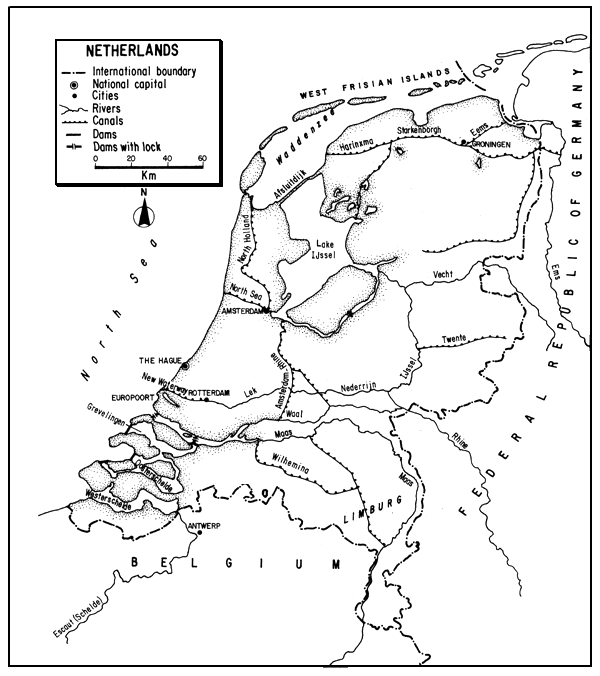
The Kingdom of the Netherlands, in northwestern Europe, lies at the mouth of Europe's greatest river and in the centre of its greatest industrial growth. With much of its land reclaimed, and almost half of it lying below sea level, it has been called, “a gift of the Rhine and the North Sea”, from which it is protected by river dikes and seawalls. Its landscape is more completely artificial than any country of similar size in Europe.
Traversed by the great distributaries of the rivers Rhine and Maas, and laced by an interconnected system of canals, ditches, sluices, lakes and reservoirs, the country provides opportunities for both commercial and sport fisheries. However, with a very dense population, and high use of almost all its lands and waters, the Netherlands is particularly vulnerable to water pollution - much of this originating without its borders.
Its once great Atlantic salmon runs are gone, and commercial fishing in inland waters, now primarily for eel, has declined greatly. The development of sport fisheries, aided by angler's organizations, has priority in the Government's plans for inland fishery management. These plans are furthered by the attention given to the value of angling as recreational activity for the dense population, and a determination to alleviate water pollution. Aquaculture to provide food from inland waters is a minor industry in the Netherlands.
| 1. | AREA: | 41 864 km2 (1988) | |
| 2. | POPULATION: | 14 748 000 (est. 1990) | Density: 361 inh/km2 |
| 3. | PHYSICAL GEOGRAPHY | ||
The Netherlands is situated in northwestern Europe between 50°45'5" and 53°52'5"N latitudes and 3°21'31" and 7°13'14"E longitudes.
Its extreme length (N–S) is about 310 km; its greatest breadth (E–W) is about 190 km. The complete altitudinal range is from -6.7 m to 321 m.
The Netherlands is bounded on the east by the Federal Republic of Germany for 584 km and on the southwest by Belgium for 496 km1. To the west and north it is bounded by the North Sea over a length of 1 370 km at flood mark (see below).
The Netherlands, forming the lowest part of the great North European Plain, consists primarily of the delta lands of the Rhine, Maas and Schelde, and adjacent parts of the North Sea lowlands. Aside from these delta areas and a series of coastal dunes, it is primarily a flat country of polders (lands reclaimed from the sea, fens or lakes) and an intricate system of static and flowing waters. About 27 percent of the land surface is below sea level, less than one percent of the country has an elevation of 50 m, and only in a few places does it rise to more than 100 m. The lower two thirds are almost flat, the rest is undulating with a few hills, high fens and heathlands.
For centuries there has been a continuous struggle against the sea with its periods of inundation and increase in salinity of the inland waters. Dunes, seawalls and dikes protect the land from sea invasion, and dikes also protect the land from river floods. There is a continual reclamation of land from the sea, now totalling almost one fifth of the country. About 40 to 50 percent of the land would be innundated by the sea if there were no man-made barriers.
There are three natural physiographic areas in the Netherlands:
an elevated strip of dunes, 9–50 m in height, along a coastal sandbar, occupied by a string of cities, and continuous except where broken by the sea;
the adjoining low polders covered with clays and peats, and
an eastern section of sandy heathland and once extensive peat bogs.
The delta areas lie in the south. Above them are the alluvial valleys of the south-central area, the joint floodplain of the Maas, Rhine and its distributary the IJssel, floored with clay and protected by dikes. The highest area of the country is the small South Limburg area in the southeast, a chalky plateau, partly wooded, and cut by tributaries of the Maas.
There is little natural vegetation in the Netherlands except in dune and heathland. Only about 8 percent is wooded and most of this is plantation area in the higher sand country.
Soils in the heathlands are primarily sandy, those in the polders mainly sea clays and peat. Overall, soils are about 50 percent sand, 40 percent clay, 8 percent peat, and 2 percent a loess-like loam.
The coastline has gradually been shortened as protective devices have been installed and more land reclaimed. In the year 1500, the shoreline was several thousand kilometres in length. It is now (1988) 1 370 km long, but if one disregards islands and estuaries it is only about 370 km in length.
4. CLIMATE
Situated in the temperate zone, the humid oceanic climate is marked by cool summers and mild winters owing to the influence of the Gulf Stream. There is generally a high cloud cover, often drizzle and mist, and the winters can sometimes be severe. Wind pressure (commonly from the west) almost always is present.
The average annual temperature is about 10°C. The average coastal temperature is about 16°C in summer and 3°C in winter; the average inland summer temperature is about 17°C and in winter about 2°C. The lowest temperatures (-1 to 1.5°C) occur in January and the highest (19–23°C) in July.
The average annual rainfall is about 750 mm, almost evenly distributed throughout the year and over the country.
The average annual evaporation is about 500 mm.
Frost averages 60 days annually. There is some snow during a period of about 10 to 45 days as one proceeds eastward. On rare occasions Lake IJssel and the mouth of the Rhine may freeze, but the Netherland's seaports are permanently open to navigation.
5. HYDROGRAPHY AND LIMNOLOGY
The smallest estimate of the area of inland waters in the Netherlands which the author has found is that of Worldmark (1988) which said that its inland water accounted for more than 2 060 km2 in 1986 (i.e., about 5 percent of the total area). An estimate of the distribution of inland waters in the Netherlands is shown in Table 1. Here, inland water is shown to constitute about 8.2 percent of the country's total area at the time. Another by Willemsen (1977) states that the area of Lake IJssel is only 120 000 ha and the total area of other lakes, rivers, canals and brooks totals 130 000 ha. This provides a total area of 250 000 ha of inland waters, or 6 percent of the country's area. A fourth estimate of the total extent of the inland waters of the Netherlands in 1987 is 3 370 km2 as is indicated in Table 51. The Centraal Bureau voor de Statistiek (1982), a more direct source, lists the inland water area as 3 704 km2 or 9 percent of a country-wide area of 41 160 km2, and the Central Bureau voor de Statistiek (1989) lists the inland water area of the Netherlands in 1985 as 9.2 percent (about 3 816 km2) of a countrywide area of 41 473 km2, a percentage of inland water surface exceeded in Europe only by Finland. A survey of 1977/78 summarized by van Haasteren and de Groot (1982) states that the total area of all surface waters in the Netherlands larger than 0.5 ha and over 6 m in width (exclusive of Lake IJssel) is 151 018 ha. Finally, Steinmetz (1982a) states that the country has 151 000 ha of available inland waters in addition to that of Lake IJssel. Using his figure of 200 000 ha for IJssel, this consitutes a total of 351 000 ha of inland water or about 8.5 percent of the total area of the country.
Table 1
Area of inland waters of the Netherlands (ha)
| Lake IJssel | 200 000 |
| Marginal lakes of Lake LJssel | 14 500 |
| Delta lakes (salt, brackish, freshwater) | 23 000 |
| Polder reservoir systems | 79 000 |
| Major rivers | 18 400 |
| Minor rivers | 2 800 |
| Other waters | 2 900 |
| Total | 340 600 |
Source: Netherlands/EIFAC (1974)
The approximate annual runoff from rainfall on Dutch territory alone is 250 mm or 10 000 million m3. Added to this is 80 000 million m3 received from upstream countries resulting in a total annual river discharge leaving the Netherlands of 90 000 million m3 (Van der Leeden, 1975; ECE, 1978). Of this total, the Rhine alone contributes about 65–75 percent.
The general drainage of the country is to the northwest into the North Sea primarily through the Rhine (Rijn in Dutch), Maas (Meuse) and their distributaries. The estuary of the Schelde (Scheldt) is also in the Netherlands. There are no other rivers of real consequence, but there is a complex hydrographic network throughout the country of rivers, canals, ditches, lakes, reservoirs, drainage canals and sluices.
In addition to the natural areas occupied by the three large rivers, two great engineering feats have greatly altered the hydrographic picture in the Netherlands. The first of these is the creation of the freshwater Lake IJssel from the former saltwater Zuiderzee (see section 5.2). The second is the Delta Plan (considered operational in 1986) which closed off three of the four principal distributary arms of the Schelde-Maas-Rhine delta from the North Sea. The estuary of the Wester Schelde is left open to traffic to Antwerp and Rotterdam (through the New Waterway). The project protects polders in Zealand, shortens the coast, prevents infiltration of sea water, and makes fresh water available for irrigation.
Throughout much of the country and throughout the year there is a vast system of lakes and canals fed with water pumped from the land. In times of heavy rain, the lakes serve to accommodate water until it can be conveyed to the sea. The excess is drained either into open water or into a boezem, the first stage of evacuation of surplus water - a means of temporary storage. This may be a lake, canal, river or marsh. With some exceptions, the waters are shallow, eutrophic and (especially the large ones) turbid.
5.1 Rivers (Rivieren)
Estimates of the length of the rivers in the Netherlands are difficult to obtain because of the many man-made waterways. Europa (1974) and Netherlands/EIFAC (1976) state that there are 6 400 km of flowing waters in the country, and Holden and Lloyd (1972) specify 1 900 km of rivers or 2 150 km including drainage ditches.
The mean annual discharge and total volume of annual runoff of the rivers in the Netherlands is shown in Table 2. The mean monthly discharge of the Rhine and Maas is shown in Table 3.
The Rhine has a drainage basin of about 224 000 km2 and a total length of about 1 350 km. As it enters the Netherlands from the Federal Republic of Germany, it has an average discharge of about 2 200 m3/sec, a maximum flow of about 12 200 m3/sec, and a minimum of about 590 m3/sec. Within the country, the Rhine breaks into three major distributaries in which the distribution of flow is listed by Hambloch (1977) as follows:
Percentage of total discharge
| Mean | High | Low | |
| Waal | 67 | 66 | 75 |
| Neder-Rijn | 22 | 11 | 16 |
| IJssel | 11 | 23 | 9 |
| Total | 100 | 100 | 100 |
Table 2
Mean discharge and annual runoff of rivers in the Netherlands
| Mean discharge (m3/sec) | Mean annual runoff (million m3) | |
| Rhine (at border) | 2 200 | 70 000 |
| Maas | 220 | 7 000 |
| Small rivers | 105 | 3 300 |
Source: Van der Leeden (1975) after Rijkswaterstaat (1964)
Table 3
Discharge of the Rhine and Maas Rivers in the Netherlands
| Rhine, Lobith (German border) | Maas, Lith | Maas, Borgharen (Belgian border) | |
| Basin area km2 | - | 28 950 | - |
| January | 2 594 | 553 | 435 |
| February | 2 813 | 591 | 465 |
| March | 2 642 | 444 | 324 |
| April | 2 775 | 429 | 311 |
| May | 2 562 | 304 | 190 |
| June | 2 517 | 193 | 115 |
| July | 2 228 | 163 | 87 |
| August | 2 020 | 151 | 83 |
| September | 1 910 | 163 | 91 |
| October | 1 656 | 184 | 112 |
| November | 1 776 | 323 | 245 |
| December | 2 569 | 572 | 453 |
| Max. monthly flow m3/s | 6 166 | 1 500 | 1 308 |
| Date | Dec. 1965 | Dec. 1965 | Dec. 1965 |
| Min. monthly flow m3/s | 808 | 34 | 6 |
| Date | Feb. 1963 | July 1964 | Oct. 1971 |
| Period of record | 1960–71 | 1960–71 | 1960–71 |
Source: Van der Leeden (1975) after Rijkswaterstaat (1973)
The IJssel proceeds northerly to Lake IJssel. The Neder-Rijn (Lower Rhine) continues west as the Lek to the New Maas and thence to the North Sea. The southernmost Waal, which carries the most water, flows west to empty into the North Sea.
The Maas (Meuse) forms a boundary between the Netherlands and Belgium for 48 km and then continues north and then west through the Netherlands to the North Sea to end its total journey of about 950 km from its source in France. Its mean discharge is about 220 m3/sec.
South of the Maas is the estuary of the Schelde. Leaving Belgium, where it forms the harbour of Antwerp, it divides into a northern channel, the Ooster Schelde, and a southern one, the Wester Schelde. The Ooster Schelde has been dammed. Both banks of the channel belong to the Netherlands.
All the other rivers in the country, constituting only four percent of the total runoff, also eventually reach the North Sea.
The gradient of all the Dutch rivers is low. For example, the fall of the Rhine, Neder-Rijn, and Waal is scarcely more than 10 cm/km. Such sluggish flow aggravates problems of pollution.
5.2 Lakes and Reservoirs (Meren, Stuwmeren)
The extreme regulation of water practised in the Netherlands makes it difficult to distinguish between natural lakes, reservoirs, and other water bodies.
Anon. (1970) classifies the lakes and impoundments in the Netherlands as follows:
Small lakes in the lower part of the country. These range in area from a few km2 to tens of km2s. Some are natural or partly natural through erosion of soft banks by wind-generated waves. Some, such as the Loosdrecht lakes near Amsterdam, are man-made through peat removal. A number of these were reclaimed for agriculture through the Seventeenth and Nineteenth centuries. Those left form part of a boezem system (see above).
Sand and gravel borrow pits. Most of these are less than 1 km2 in area, but some are much larger, e.g., the 4.7-ha Lake Vechten.
Former tidal inlets in the delta. These have been dammed and the original saline and brackish water is being replaced with fresh water.
Lake IJssel. The largest body of fresh water in the country (IJsselmeer in Dutch) was created from a marine bay (salinity 10 ppt), the Zuiderzee, by a 30-km seawall, the Afsluitdijk, completed in 1932. The Zuiderzee itself was formed in the Middle Ages through penetration of the North Sea. The lake's original area of 3 600 km2 has been reduced through poldering to about 2 000 km2. Its fresh water is supplied by the Rhine's distributary, the IJssel River. The lake supplies agriculture and industry and checks infiltration of salt water into the subsoil. Constituting almost half of the inland waters of the country, it is highly important with respect to commercial and recreational fishing. Some parameters of the Lake are seen in Table 4.
One of the severest problems in water quality management of the freshwater Dutch lakes is eutrophication. About two thirds of this freshwater supply is from the Rhine which bears many nutrients; furthermore, most of the lakes are shallow and unstratified (see Los, De Rooij and Smits, 1984).
See Table 1 with respect to the extent of other static waters.
5.3 Canals (Kanalen)
The Netherlands has a famed and extensive canal system linking both its natural and artificial waterways and connecting them with many canal or river parts in Belgium, Germany and France. In 1987 there were 3 529 km of navigable canals in the Netherlands. They require continual dredging.
Among the major canals are those connecting large parts with the North Sea, the 27-km New Waterway for Rotterdam, and the 29-km North Sea Canal for Amsterdam. Amsterdam is also served by the Amsterdam-Rhine Canal connecting Amsterdam with the Waal River and making it a Rhine port. Other canals include the V. Harinxma, Ems, Juliana and Wilhelmina.
In addition to canals, the Netherlands have about 350 000–400 000 km of ditches, primarily to improve drainage. Shallow and often choked with vegetation, they furnish little fish habitat (Beltman, 1984).
Table 4
Characteristics of Lake IJssel
| Parameter | |
| Area (km2) | 1 200a |
| Mean depth (m) | 4 |
| Maximum depth (m) | 10.2 |
| Bottom | sand/clay |
| Mean water temperature (°C) | 10.4 |
| Maximum water temperature (°C) | 24.5 |
| Transparency (Secchi disc, m) | 0.65 (0.1–2.0) |
| pH, winter/summer | 7.5–8.0/8.2–8.7 |
| Oxygen saturation (%) | 90–120 |
| P-Ptot (mg/l) | 0.22 |
| N-Ntot (mg/l) | 4 |
| Cl (mg/l) | 220 |
| Primary production, entire year (g.cm-2. day-1) | 2 |
| Average residence time (mo) | 6–9 |
a Steinmetz (1982a) and others say that its area is 2 000 km2
Source: Willemsen (1977)
6. LAND AND WATER USE
Table 5
Pattern of land use in the Netherlands, 1987
| Percent | |
| Arable and permanent crops | 24.3 |
| Permanent pasture | 29.7 |
| Forests and woodland | 8.0 |
| Other land | 29.0 |
| Inland water | 9.0 |
| Total | 100.0 |
Source: 1987 FAO Prod.Yearb., 41 (Publ. 1988)
Diking in the Netherlands began in the Seventh Century, and since then man has actively continued to shape the lands and waters of the country. He has cleared the lands of vegetation, cut peat, dug clays and gravels, leveed and channelized the rivers, augmented the natural waterways through construction of canals and locks, built dikes and sluices, drained lakes, reclaimed vast areas of the sea through the erection of seawalls, pumped out water from the resulting enclosures, and flushed out both land and water areas with fresh water1. It has become difficult, therefore, to distinguish between natural and artificial elements of the geo- and hydrosphere.
1 Higher polders can be drained by sluice at low tide; lower ones have to be pumped out
The economy of the Netherlands, now about 88.5 percent urban and 11.5 percent rural, plus its peculiar hydrographic conditions result in highly integrated and special uses of water. These special uses include flushing of boezems, control of water levels, and protection against salt water intrusion. In agriculture, water is chiefly used to keep the salt well above the surface of the ground. Its use for irrigation is comparatively new. Although about 14 percent of the country was said to be irrigated (1986), drainage, rather than irrigation, is the principal element of water control1.
1 In 1982, only about 7 percent of the country was reported as irrigated
Although such a densely populated nation must depend largely upon industry, it is also an intensively agricultural country, being the world's third largest exporter of agricultural products. The proportion of farmed land is high and agriculture is diverse and intense. There is high use of fertilizer (about 500 kg/ha/year) and mechanization. Cereals, fodder crops, vegetable, and flower crops are cultivated. The basis of the agricultural economy is, however, animal husbandry with much of the crop production consumed by dairy and meat cattle.
Almost no effort is devoted to forestry; the Netherlands ranks at the lowest level in Europe in roundwood production. Most of the “forests” are recent plantations (e.g., of Scots pine) in the sand country.
For many years, peat was cut for domestic and industrial use. Some of the cuts were drained, others have persisted to be used for fishing. Extensive gravel pits have also been left on the floodplains. There are very large reserves of natural gas, some coal (in Limburg), oil, gravel and salt. Otherwise, mining is not important.
Despite the lack of basic resources (such as iron), industrial development is high. Oil refining, chemicals, metallurgy, electrical equipment, steel, textiles, food processing and shipbuilding constitute the bulk of industrial output. Although concentrated in the Rotterdam-Amsterdam area, industry is rather widely distributed, thus increasing country-wide pollution.
There is little hydroelectric power development because of the flat terrain; in 1987 there was only about 2 000 kW. Total installed thermal power was 16 866 000 kW and there were also 508 000 kW of nuclear power, and 10 000 kW of geothermal power.
The Netherlands have one of the most extensive systems of navigable waterways in the world, consisting of a maze of the major rivers and canals. In 1987, there were 4 831 km of navigable rivers and canals plus 460 km on Lake IJssel and other waters; the highest percentage of waterways per unit area in Europe. Canals and other waterways function here for both drainage and transport, and are recipients of effluents. They provide a great deal of aquatic recreation: rowing, canoeing, water skiing, and yachting. They serve to disseminate fish throughout the country and provide fishing. Much of the waterway system was developed not for transport, but as defence against flooding. Nevertheless, about one third of the country's freight is carried on the inland waters by a fleet totalling about 5 million tons, including about 12 000 barges, which contributes to the pollutional load. The Rhine is Europe's most intensively navigated river. Rotterdam, at its lower end, is the world's largest port, and the Rhine is navigable upstream for 882 km to Basle.
There is a good system of State railways (2 867 km) used mostly for passenger travel, and an extremely well-developed system of over 111 000 km of surface roads enabling easy access to any section of the country. These roads have a density of about 2.7 km/km2 (1986) and private automobile ownership is 347 per thousand (1987). There are about 12 000 km of bicycle roads and a bicycle ownership of about 746 per thousand (1987). However, despite the good transport system, most Dutch fishermen fish quite close to their homes, and this factor is taken into account by Government planners.
Concentrated for many years on the herring fishery, the contribution of marine fishing to the total Dutch economy is now marginal, but still important in some coastal areas. The Netherlands ranked thirty-fourth in total world fishing catch in 1987. A once thriving oyster fishery was virtually destroyed by flood control and land-gaining processes, and production of mussels in the estuaries now produces a far greater tonnage. Its future is also dependent upon the effect of dikes in the Schelde area. The main area of inland commercial fishing is Lake IJssel (see section 7.1.1). Per caput consumption of fish in the Netherlands is 10.3 kg (1984).
Water pollution is obviously a major problem of the country. The Rhine's salinity has increased eleven-fold over the last century, and much of its bed is covered with oily sludge. Bearing about 17 million tons of waste (phenols, organic matter, salts, etc.) annually, it enters the Netherlands in a very polluted condition. Johnson and Brown (1976) said that this was about one half of the total produced in the country. The Dutch waterways are used extensively for the conveyance of waste and the drainage from agricultural lands. Sewage, organic effluents from processing industries, and those from a multitude of other industries create serious conditions for aquatic life. Major industrial pollutants include effluent from potato flour, strawboard, sugar beets, dairies, food processors, paper, pulp and chemicals.
The large volume of water in the main rivers dilutes effluent to some extent, but the smaller, slow-moving canals are in much poorer condition. Furthermore, infiltration of sea water through dikes and sluices has led to increased salinity. In 1972, it was considered that over 95 percent of the rivers (including drainage canals) was polluted and 200 km rendered more or less fishless.
The Netherlands experiences great difficulties in procuring, storing and processing sufficient good water for drinking supply. One method of achieving this need is replenishment of ground water supplies through coastal dune storage. However, the dune water table has lowered, aquifers are limited, and the use of ground water lowers the water table and affects agriculture adversely. By the year 2000, over one half of the water will have to be derived from the great rivers, principally the Rhine (see section 9.3).
Many studies have been made of the use of water in the Netherlands. One such, Table 6, is a projection of water demand 1980–2000. The extremely large amount of water required to maintain water balance through flushing of boezems and other discharges illustrates a startling need unlike that of other European countries.
All such changes in land and water use have effect not only upon the aquatic resources but also upon their utilization. For example, as new land is created, new communities have arisen and the conversion of “dry” areas into “wet” areas has changed the fishing patterns of the recreational community.
Table 6
Projected water demand, 1980–2000, in the Netherlands
| m3/sec | mm | 109m3a | ||||
| Needs and losses | 1980 | 2000 | 1980 | 2000 | 1980 | 2000 |
| Average evaporation | 630 | 630 | 500 | 500 | 20 | 20 |
| Domestic water use | 19 | 33.5 | 15 | 27 | 0.6 | 1.1 |
| Industrial use | 51 | 86.5 | 40 | 69 | 1.6 | 2.7 |
Flushing of boezems, control of water levels, discharge to main rivers to combat salt water intrusion | 1 680 | 1 680 | 1 335 | 1 335 | 53 | 53 |
Additional flushing due to supplementary irrigation | 35 | 44 | 28 | 35 | 1.1 | 1.4 |
| Excess | 1 060 | 1 001 | 840 | 792 | 34 | 32.1 |
| Total | 3 475 | 3 475 | 2 758 | 2 758 | 110.3 | 110.3 |
Source: Van der Leeden (1975) after Rijkswaterstaat (1964)
7. FISH AND FISHERIES
There are about 42 species of fish in the inland waters of the Netherlands. Most of these are best adapted to eutrophic waters. The principal freshwater and diadromous fishes entering the catches are: the European eel (Anguilla anguilla), European smelt (Osmerus esperlanus), pike (Esox lucius), common carp (Cyprinus carpio), bream (Abramis brama), roach (Rutilus rutilus), rudd (Scardinius erythrophthalmus), tench (Tinca tinca), European perch (Perca fluviatilus), and pike-perch (Stizostedion lucioperca). Others include: Twaite shad (Alosa fallax), brown and sea trout (Salmo trutta), the introduced rainbow trout (Oncorhynchus mykiss), barbel (Barbus barbus), white bream (Blicca bjoerkna), crucian carp (Carassius carassius), orfe (Leuciscus idus), chub (L. cephalus) and burbot (Lota lota). The flounder (Platichthys flesus) also enters the inland catch. (See especially, Ministerie van Landouvw en Visserij, 1972, for an account of the principal inland fishes.)
An addition to the Netherlands aquatic fauna is the introduced grass carp (Ctenopharyngodon idella). Since 1977, 20 000–30 000 kg of grass carp have been stocked annually as an alternative to chemical weed control and they are also fished.
At one time, the Rhine was the greatest Atlantic salmon (Salmo salar) river in Europe. Late in the nineteenth century, the lower reaches yielded more than 100 000 salmon averaging almost 7 kg in the Netherlands alone (Schwiebert, 1975). But dams, water pollution and other manmade hazards have ended the fine runs that used to enter the Dutch rivers. Deelder and Van Drimmelen (1960) provide an excellent picture of the decline of both the Atlantic salmon and eel fisheries in the Rhine and Maas. Today, salmonoid fisheries in the Netherlands are chiefly for those fish which are stocked, i.e., brown and rainbow trout, although there are some grayling (Thymallus thymallus) in small brooks.
7.1 Capture Fisheries
Except for Lake IJssel, which constitutes over half of the Netherland's inland waters, sport fishing is now considered to have priority over professional fishing in Governmental policy (Steinmetz, 1982a). A considerable commercial fishery still exists in the inland waters, however, as will be seen below.
7.1.1 Commercial fishing
Table 7 illustrates the commercial catch in the inland waters of the Netherlands during the period of 1965–87 as reported to FAO. The total catches in this table agree closely with those recorded in the Netherlands Statistical Yearbook (e.g., that for 1983) and other publications emanating from the Netherlands (e.g., Steinmetz, 1988). From this table, it will be seen that the once greatest catch, i.e., “freshwater fishes n.e.i.” (principally various cyprinids) has declined materially. In recent years the greatest commercial catches have been of bream, eel, European perch and European smelt. Although not illustrated in these statistics, tench is also given priority as a commercial species.
Table 8, showing the derivation of the inland commercial catch 1974, demonstrates the high percentage of fish (77 percent) taken from Lake IJssel alone. Comparison of Tables 7 and 9 also illustrates the high percentage of the nation's catch of three important species caught in Lake IJssel alone. Thus, in 1977, the following percentages of the nation's commercial inland catch were taken from Lake IJssel: European perch - 96 percent, pike-perch - 96 percent; European eel - 92 percent. It is also obvious from Table 9 that sport fishing in IJssel has little influence on the commercial catch.
Commercial fishing in Lake IJssel employs about 400 men with 120 boats (1984), and includes the use of various nets, longlines and pots. Longlines for eel fishing have been almost supplanted by baited eel pots (boxes). The number of fyke nets has been stabilized in order to protect the perch and pikeperch stocks.
7.1.2 Sport fishing
In general, no distinction is made in the Netherlands between game, sport or food fishes, although sport fishermen are defined as those who fish with one or two rods or a bob.
Table 11 lists some of the fishes most frequently caught by sport fishermen as well as indicating their relative abundance in catches made in Lake IJssel. To this list should be added the species enumerated above (head of section 7).
Most sport fishing in the Netherlands is a sedentary activity - fishing from the banks, especially for cyprinids. About 10 percent of the sport fishermen practice boat fishing usually or exclusively, with perch and pike-perch as major quarry. Trout fishing is primarily for stocked fish. A substitute for trout by fly fishermen is the rudd, which is stocked for this purpose. The use of angler-caught coarse fish as food is limited. On the average, over 80 percent of the fish caught are released, with the exception of eel, pike-perch and pike, of which about 60, 35 and 35 percent respectively are taken home (Steinmetz, 1982a). See also Table 9. The official landed commercial catches from Lake IJssel in 1986 and 1987 are given in Table 10.
Table 7
Nominal catches by species in the inland waters of the Netherlands, 1965, 1970, 1975, 1980–87 (in tons)
| Species | 1965 | 1970 | 1975 | 1980 | 1981 | 1982 | 1983 | 1984 | 1985 | 1986 | 1987 |
Freshwater breama (Abramis brama) | 100 | 200 | 159 | 83 | 94 | 177 | 430 | 534 | 626 | 739 | 1 405 |
Common carp (Cyprinus carpio) | 0 | 0 | 1 | 1 | 1 | 1 | 1 | 2 | 2 | 2 | 1 |
Roaches (Rutilus sp.) | 300 | 200 | 57 | 24 | 55 | 71 | 112 | 275 | 162 | 89 | 33 |
| Pike (Esox lucius) | 0 | 0 | 0 | 1 | 1 | 0 | 0 | 1 | 1 | 0 | 1 |
European perch (Perca fluviatilis) | 200 | 100 | 846 | 625 | 848 | 711 | 631 | 442 | 622 | 559 | 545 |
Pike-perch (Stizostedion lucioperca) | 100 | 200 | 1 209 | 139 | 65 | 73 | 167 | 333 | 159 | 60 | 129 |
| Freshwater fishes n.e.i. | 10 700 | 100 | 994 | 248 | 0 | 51 | 299 | 184 | 140 | 77 | 85 |
European eel (Anguilla anguilla) | 2 400 | 1 100 | 1 040 | 690 | 723 | 876 | 972 | 723 | 708 | 785 | 559 |
| Trout (Salmo sp.) | 0 | 0 | 0 | 1 | 1 | 1 | 1 | 1 | 1 | 1 | 2 |
European smelt (Osmerus eperlanus) | 0 | 100 | 107 | 164 | 160 | 2 401 | 1 285 | 1 357 | 1 411 | 1 956 | 2 409 |
European flounder (Platichthys flesus) | - | - | 8 | 7 | 4 | 2 | 2 | 4 | 2 | 2 | 10 |
| Total | 13 800 | 2 000 | 4 421 | 1 983 | 1 952 | 4 364 | 3 900 | 3 856 | 3 834 | 4 270 | 5 179 |
a Listed as “Freshwater breams, n.e.i. Abramis spp.” in 1965–69 statistics
- This category not listed this year
Source: 1965–69 Yearb.Fish.Stat.FAO, 36 (Publ. 1974)
1970–83 FAO Fish. Dept. Fishery Statistical Database (FISHDAB)
1984–87 Yearb.Fish.Stat.FAO, 64 (Publ. 1989)
Table 8
Commercial catch in the inland waters of the Netherlands, 1974 (in tons)
| Species | Lake IJssel | Marginal lakes of IJssel | Delta lakes | Polder reservoirs | Major rivers | Other waters | ||
| Bream and roach | 263 | 139 | - | ? | 200e | - | ||
| European perch | 758 | - | - | ? | - | - | ||
| Pike-perch | 205 | - | - | ? | - | - | ||
“Coarse fish - not specified” | 1 230 | a | - | 300e | b | ? | ? | - |
| European eel | 843 | 843 | 81 | 79e | 20e | ? | ||
| Total | 3 299 | 280 | 381 | 79e | 220e | ? | ||
a Includes 0.1 t sea trout, 22 t European smelt, 14 t European flounder
b Plaice (Pleuronectes platessa) and European flounder
Source: Netherlands/EIFAC (1974)
Table 9
Estimated withdrawals of fully grown perch, pike-perch and eel from Lake IJssel, 1977
| Species | Sport fishinga | Commercial fishing | All fishing | |||
| kg | % | kg | % | kg | % | |
| European perch | 50 400 | 8.8 | 524 067 | 91.2 | 574 467 | 100 |
| Pike-perch | 18 800 | 2.0 | 936 565 | 98.0 | 955 365 | 100 |
| European eel | 1 350 | 0.2 | 783 375 | 99.8 | 784 725 | 100 |
| Total | 70 550 | 3.0 | 2 244 007 | 97.0 | 2 314 557 | 100 |
Source: Van Ginkel (1982)
Public participation in sport fishing is far less in the Netherlands than, say, in the Scandanavian countries, but after the second world war Dutch sport fishing increased decidely and became one of the top outdoor activities. It rose to 545 413 licensed anglers in 1964–75 (about 4 percent of the total population), to 982 000 (7.1 percent of the total population) in 1977–78, and to over one million circa 1980. Another 650 000 (people under 15 years of age) required no licence to fish with one rod. In addition, there were estimated to be 300 000–400 000 illegal anglers (Steinmetz, 1982). Based on an estimated population of 14 082 000 in early 1980, the number of licensed sport fishermen in the Netherlands would have been about 7 percent, but the number of persons actually fishing was considered to be about 2.1 million or about 15 percent of the total population.
In 1983/84 there were about 918 000 licensed sport fishermen, but this number had decreased to only 741 000 in 1984/85, to 718 000 in 1985/86, 614 000 in 1986, and to about 605 000 in 1987 (Steinmetz, 1988). With only about 4.2 percent of the estimated population in 1986 licensed, such a decline is unusual. Among the reasons given by people for their non-participation in this sport were: that they had changed to other forms of recreational activities; that they had no time; or that they scarcely ever fished (personal communication by Dr B. Steinmetz, May 1990).
In the Netherlands, where space is at a premium, foreign fishermen have not been encouraged - as they are in some European countries.
Studies by de Groot and van Haasteren (1979) and van Haasteren and de Groot (1982) discuss the factors limiting the extent of sport fishing in the Netherlands restriction of fishing rights or entry, inaccessibility, unfishable slopes, unsuitable depths, too much overgrowth, poor water quality, utilization by other parties, etc. About 15 percent of the Dutch population go fishing once or several times a year, and on a “standard day” there are 110 000 people fishing - thus indicating the “required number of fishing places”. They consider that only about 11 000 km of a total shore length of 35 500 km is available for sport fishing. On the assumption that 25 m is the space required between anglers, they estimate that there is technically enough space for 434 000 fishermen to practice shore-fishing simultaneously.
Table 10
Commercial catch from Lake IJssel, 1986 and 1987 (in tons)a
| 1986 | 1987 | |
| Cyprinids | 779 | 1 284 |
| European perch | 538 | 488 |
| Pike-perch | 58 | 111 |
| European eel | 775 | 538 |
| European smelt | 1 881 | 2 317 |
| Total | 4 011 | 4 738 |
Source: Steinmetz (1988)
Table 11
Estimated annual catches by sport fishermen at Lake IJssel based on surveys made in 1976 and 1977
| Species | Number | Percent |
| Bream and white bream | 100 000 | 6.7 |
| Roach | 914 000 | 61.6 |
| Chub and orfe | 7 500 | 0.5 |
| Common carp | 1 000 | 0.1 |
| European perch | 375 000 | 25.3 |
| Pike-perch | 54 000 | 3.6 |
| European eel | 33 000 | 2.2 |
| Total | 1 484 500 | 100.0 |
Source: Van Ginkel (1982)
Of the total available inland waters (151 000 ha excluding Lake IJssel) fishing rights for 93 600 ha are in the hands of organizations of sport fishermen and 28 000 additional ha are accessible to them by permit. In 102 000 ha of the 151 000 ha, fishing with one “normal” rod for fish such as the cyprinids is free because these waters are navigable streams with regular traffic of persons or goods of economic value (Steinmetz, 1982a).
Although the social aspects of sport fishing in the Netherlands have received more study than its economic aspects, it was estimated in 1974 that the gear of about 790 000 licensed fishermen was worth U.S.$ 12 million, and their boats and trailers an additional U.S.$ 6 million (Steinmetz, 1982a).
7.2 Aquaculture
Several species of fish are cultivated in the Netherlands, but about 90 percent of their production is used to stock waters for the benefit of anglers. Fish which have been cultivated for this purpose include: rainbow and brown trout, pike, common carp, rudd, grass carp (Ctenopharyngodon idella), European perch, and pike-perch. For example, in 1983, the Organization for Improvement of Inland Fisheries (OVB) reared and stocked the following: common carp (54 t), grass carp (31 t), rudd (5.5 t), pike (473 000), perch (49 200), and pike-perch (111 700). The number of fish stocked from year to year depends on the weather, predation from birds, and other factors; for example, in 1982 no perch were stocked but 10.5 t of rainbow trout were planted (Steinmetz, 1984; Organisatie ter Verbetering van de Binnenvisserij, 1984). Transfers of fish from open waters are also made, e.g., bream, roach and eels caught at outlets to the sea. The bream are sometimes removed to stimulate growth in the remaining population, and to decrease competition for benthic food with the commercially valuable eel. Conversely, roach caught by commercial fishermen are transferred to sport fishing waters. However, recent studies are beginning to question the efficacy of such measures as well as that of stocking pike -as opposed to habitat improvement (see Cazemier, 1984; Grimm, 1984; Riemens, 1984).
Pinot and Kirk (1982) say that the Netherlands produces 50 t of trout annually for commercial purposes. Brown (1983) states that 50–60 t of rainbow trout are cultivated commercially in the Netherlands for annual sale as food fish, and that negligible quantities are exported. Fish Farm. Inter., 12(2) (1985) says that in 1983 the Netherlands raised 200 t of freshwater trout, 50 t of seawater trout, and 90 t of eel. The FES (1989) does not list the Netherlands in its tables of trout and salmon production, but Steinmetz (1986) provides a rough estimate of 200 t of salmonids and 100 t of eel as raised for consumption in the Netherlands in 1984, and Steinmetz (1988) lists a similar production of salmonids as 200 t in 1986 and 190 t in 1987 and of eel as 100 t in 1986 and 200 t in 1987. FAO Fish.Info. Data and Stat.Serv. (1989) provide the following data on production of fish from aquaculture in the Netherlands during the 1984–87 period: Clarias spp. from 20 t (1984) to 300 t in 1987; European eel from 20 t (1985) to 200 t in 1987; European eel from 20 t (1985) to 200 t in 1987; rainbow trout from 150 t (1984) to 200 t in 1987. There is also some put-and-take trout fishing on some Dutch farms.
In culturing fish in the Netherlands, ponds, raceways (for trout), glass houses, recirculation systems, and cages utilizing power plant effluent have all been used.
The African catfish, Clarius gariepinus (formerly C. gazera) has recently been introduced to commercial fish culture in the Netherlands. Steinmetz (1966) gives a rough estimate of its production in the country as 15 t in 1984, 90 t in 1985 and Steinmetz (1988) lists its production for consumption as 300 t in both 1986 and 1987. This catfish has the advantage of tolerating low oxygen levels, and having a good food conversion, but it presents a severe marketing challenge in the Netherlands with respect to its acceptability.
8. OWNERSHIP, ADMINISTRATION, MANAGEMENT, INVESTIGATION AND AGREEMENTS1
8.1 Ownership, Availability and Licensing
8.1.1 Fishing rights as a rule belong to the owner of the water. The owner may be the State, Province, a local authority, a foundation, private person, etc. There are, however, some waters (mainly along river banks) where the fishing rights are separated from ownership of the water due to historical rights established before 1838. Since then, separation of the two rights is forbidden by law.
A fisherman is authorized to fish in a certain water only if he owns the fishing right, or has obtained it by tenancy agreement, or if he is the holder of a permit obtained from the owner of the right. No such permit is required for use of one “common rod” (see below) for fishing in waters frequently used as navigable waterways.
Transfer of fishing rights by lease or permit is possible with approval by the Chamber for Inland Fisheries (see section 8.4).
8.1.2 Licensing. Fishing in inland waters either commercially or for sport requires a governmental certificate which is issued through the postal offices. The following licences are required:
“Large fishing licence” (grote visacte) for all types of fishing permitted by law, e.g., with gill or fyke nets;
“Minor fishing licence (kleine visacte) for fishing with two rods, a bob, spinning and live bait;
Children under fifteen years of age do not require an angling licence.
8.2 Legislative Authority
The Dutch Fisheries Law of 1963 with decrees and possible revisions is a direct responsibility of the Minister of Agriculture and Fisheries (see below). It covers all regulations with respect to: legal sizes, seasons, licences, gear, the tasks and responsibilities of the OVB (see section 8.5), etc.
8.3 Administration
The administration of all fisheries in the Netherlands rests with the Ministry of Agriculture, Nature Management and Fisheries.
Two Departments are responsible for inland fisheries:
The Directorate of Fisheries for the governmental policy concerning fish stocks and commercial fisheries, and
Directorate of Outdoor Recreation for sport fisheries.
8.4 Other Concerned Governmental Agencies
Netherlands Institute for Fisheries Research. Part of the Ministry of Agriculture, Nature Management and Fisheries, it is responsible for fisheries research;
Chamber for the Inland Fisheries. All agreements concerning fishing rights either by lease or permit require approval by this Chamber (created in 1955). Its main tasks ordered by Fisheries Law are to control agreements for the effectiveness of fishing proposed for a specific body of water, and to protect professional fishermen against unsuitable prices.
Institute for Land and Water Management Research. The behavioural aspects of sport fishermen are considered in relation to land development projects and studies.
Limnological Institute Tjeukemeer Laboratory
Delta Institute for Hydrobiological Research, Royal Academy of Sciences. Estuarial changes
Research Institute for Nature Management
Directorate-General of Nature Conservation, Recreation and Media (Ministry of Culture, Recreation and Social Welfare). Responsible for total outdoor recreation including creation of some facilities for sport fishing. The Ministry also makes laws concerning a number of fish species forbidden to catch (in most cases of no importance to fishermen).
8.5 Semi-governmental Organizations
Marketing Board for Fish and Fishery Products
Board of Fisheries Industry
Organization for Improvement of Inland Fisheries (OVB). Created in 1952, its aim is to improve inland fisheries through education, extension to fishery managers, stocking and other measures, such as financial support focused on improvement of the fish stocks or fishing water.
Institute for Fishery Products
8.6 National Organizations of Sport and Professional Fishermen1
Dutch Union of Associations of Sportfishermen (NVVS)
Central Dutch Organization of Sportfishermen (CNHV)
Association of Fishermen on Lake IJssel and Adjacent Lakes
Association of Freshwater Professional Fishermen
8.7 Management
Since 1970, eel and (sometimes) tench management is in general the responsibility of professional fishermen, while the general responsibility for the management of other inland fish is in the hands of the sport fishermen. In 1984, it was estimated that some 5 000 people were concerned in the management of inland fish stocks in the Netherlands: most of them members of angling clubs and about 300 commercial fishermen (Steinmetz, 1982; 1984).
8.8 International Agreements
The outlines of an international statute dealing with the Maas and Schelde with respect to their use by the Netherlands and Belgium were laid down in 1839 and amended since then. Negotiations with respect to new treaties were still in progress in 1983. A Dutch-Belgian Commission was established in 1978 to study matters arising from the management of small rivers and groundwater extraction.
A Permanent Boundary Water Commission was set up in 1963, under the aegis of the Dutch-German Border Treaty, to deal with mutual interest in water management such as the hydrological regime of the rivers.
The Netherlands belongs to the International Commission for the Protection of the Rhine against pollution, established in 1950, given legal authority by a treaty signed in 1963, enhanced by other treaties completed in 1976, and signed by the Netherlands, France, the Federal Republic of Germany, Luxembourg, Switzerland, and the European Economic Community (EEC). The International Commission is charged with drawing up permit and discharge standards and will fix the maximum tolerable levels of pollution. The Netherlands also belongs to the Central Commission for Navigation on the Rhine to guarantee freedom of navigation on this river and signed by interested countries in 1868. Members also include France, the Federal Republic of Germany, Switzerland and the UK.
9. STATE OF THE FISHERY
9.1 Yield
The yield per unit surface area for one of the most important inland fish in the Netherlands, the European eel, has varied considerably depending upon the year and area. In Lake IJssel, the yield of eel during 1954–62 (when the lake area was 220 000 ha) was around 10 kg/ha/year according to Tesch (1977), still about 10 kg/ha/year in 1967 (Deelder, 1970). But in 1977, the yield of eel from all types of fishing in Lake IJssel (assuming an area of 200 000 ha) was only 3.9 kg/ha/year (see Table 9). This is approximately the same yield (3.8 kg/ha/year) of eel to be calculated from the commercial catch data shown for 1986 in Table 10. Meanwhile, according to Deelder (1970), another Dutch lake had a yield of about 20 kg/ha/year of eel in 1967, and yields of eel to about 60 kg/ha/year are known from some Dutch areas.
Some concepts of changes in both total catch and yield per unit area can be obtained by noting some of the changes in catch of other species that have occurred at Lake IJssel - especially important because IJssel comprises almost half of the Dutch inland waters. Netherlands/EIFAC (1974) pointed out that the catch of European perch in IJssel rose from 186 t in 1971 to 588 t in 1973, while during the same period pike-perch catches declined from 1 207 t to 660 t. The yields per hectare for these two species would then be as follows: for perch, 0.94 in 1971 and 2.9 in 1973; for pike-perch, 6.1 in 1971 and 3.3 in 19731. Willemsen (1977) notes the trend for perch in Lake IJssel from 0.7 kg/ha/year in 1970 to 4.0 kg/ha/year in 1975. Commercial yields per year per hectare from these two species as calculated from Table 10 are as follows: perch - 2.7 kg in 1986 and 2.4 kg in 1987; pike-perch - 0.3 kg in 1986 and 0.55 kg in 1987.
However, the figures given above should by no means be considered exact. See especially the footnote to Table 10. Furthermore, writers do not seem to agree on the area of Lake IJssel. For example, Steinmetz (1988) records its area as 180 000 ha on one page (p. 67) and as 200 000 ha on page 68.
Table 9 lists some catch estimates at Lake IJssel for 1977 which show a total yield of almost 11.2 kg/ha/year for the species of most interest to commercial fishermen. It will be noted that the total catch by sports fishermen in this lake in 1977 was only 3 percent of the total catch, a negligible quantity - making a total yield of these desirable fishes of only 11.6 kg/ha/year.
The overall catches from inland commercial fisheries, as reported in the FAO Yearbook of Fishery Statistics (Table 7) declined decidedly during the period of 1965–87 - from a high of 15 900 t in 1966 to only 1 856 t in 1978. The decline is represented primarily by a reduction in the catch of a group of species not identified in the catch statistics but believed to be composed mainly of minor cyprinids. The catch of eels has also declined decidedly, from 2 700 t in 1967 to only 552 t in 1979.
The statistics cited may not indicate any startling decline in the fisheries for other desirable species. Fluctuations such as those for pike-perch, for example, which are very high, may be due to dominance of year-classes (Netherlands/EIFAC, 1974; Steinmetz, 1988). On the other hand the eel stock of Lake IJssel seems to be almost depleted by the fishery (Steinmetz, 1988).
9.2 Factors Affecting the Fishery
The small size of the Netherlands, its dense population and intensive use of land and water, and the overwhelming fact that most of its freshwater supply originates from outside the country - well beyond the capacity of the Dutch alone to improve its quality - are basic elements in determining fish production.
Lack of suitable spawning grounds and the generally eutrophic waters restrict salmonoid production, the turbid waters favour such species as pike-perch, and brackishwater conditions in some areas even favour the catch of such species as the flounder (Pleuronectes flevus). On the other hand, some of the cyprinids which thrive well are unappreciated by the Dutch fisherman.
Although much of the country is fundamentally deltaic, a normally favourable condition for many inland fisheries, the original hydrographic pattern has been altered for centuries and is continuing to be altered. Meanders have been shortened, overflow areas curtailed by levees and drained, and large salt and freshwater areas have been reclaimed to furnish agricultural land - all measures that have reduced aquatic habitat. Conversely, some salt water areas have been converted into freshwater lakes.
The heavy pollution in parts of the Netherlands is also to a large extent, a result of its geography. Lying as it does, at the bottom of Rhine-Maas system, it derives a large portion of its polluting agents from the heavily industrialized upstream countries2. In addition, intensive use of its inland waters for transport and both planned and inadvertent disposal of effluents further lower its productivity for fish. As in many other European countries, the diminution of phosphorus loading is being practiced to lower eutrophication. For example, in the Loosdrecht lakes, water will be replaced by a supply in which the P concentration has been lowered (Van Liere et al., 1984). Today almost all effluents are treated in water purification plants, in some cases, even with a third phase purification to diminish the phosphate load on recipient waters.
With a yearly total discharge from its rivers of 90 000 million m3, the annual runoff per caput is approximately 6 102 m3. However, if one considers only the runoff originating within the Netherlands, one derives an annual runoff per caput of only 678 m3.
Aside from pollution, the formerly abundant anadromous fish population, especially that of Atlantic salmon in the Rhine, has been decimated by water regulation (through dams and canalization, spawning areas were lost) and by the presence of barriers to migration. Conversely, the spread of fishes, especially exotics, has been greatly facilitated by the numerous water connexions.
Apart from Lake IJssel, the present area of inland waters that can support the fish stock is not more than about 151 000 ha. Consequently, fishing pressure, especially in the rest of the country, is severe. The Governmental policy now tends to separate eel fishing mainly reserved for professional fishermen, from fishing for other species, mostly reserved for recreational fishermen.
The yield from inland fisheries in the Netherlands is greatly affected by the continual changes in the quantity of surface waters available (it has actually been increasing) and in its quality - whether due to pollution, changes in salinity, or rises in temperature caused by thermal power stations. A decline in vegetated areas is considered responsible for the continued decline of pike. Water level management for agricultural purposes in Dutch polders and eutrophication are considered to be the major reasons for this decrease.
The management of these fisheries requires a careful but continually changing programme. It includes: habitat improvement including pollution control and weed removal, maintenance and construction of fish passes, stocking and transfer of stocks to augment natural propagation, introduction of exotics and hybrids, changes in fishing regulations, provision of fishing space and better access including launching sites, and changes in depth and slopes at fishing areas. Such measures are, of course, not unique to the Netherlands, but its changing ecological and sociological conditions bring them into intense multiple play.
As Gaudet (1973) and Steinmetz (1982a) have summarized the situation, until about 50 years ago in the Netherlands, inland fisheries were mainly in the hands of professional fishermen, and the fishing effort was well spread over all species of which the fish stocks were composed. Several factors have, however, changed this picture completely. Canalization and pollution of the major rivers and their tributaries have put an end to the great salmon fisheries, and affected the wellbeing and economic value of other species, especially trout, shad, eel and some coarse fishes. Secondly, there has been some overfishing and fishing has become more selective. Apart from a certain amount of bream, roach and carp, cyprinids are hardly caught commercially now because there is no market for them. This opens the door to unbalanced fish populations with all its dangers. finally, since the second world war, and in part due to the creation of new cities coupled with land reclamation, the development of recreational fisheries has been explosive. Furthermore, in some areas, its growth has been at the expense of commercial fisheries.
9.3 Prospect
The general prospects for future water use, as well as their implications for fisheries, have been outlined in section 6. There are, of course, some overwhelming difficulties concerning the provision of water of good quality for fisheries - especially when about 90 percent originates outside the borders of the country and reaches them in a severely polluted condition. However, in recent years some far going agreements have been reached between the several Rhine countries concerning both pollution and habitat improvement1. Furthermore, the Netherlands has set some firm goals toward overall water improvement. According to Johnson and Brown (1976), “In general the national goal is that water should be of adequate quality that, when treated, it can serve as the basis for drinking water and be usable for industrial purposes and suitable for agriculture and for recreation and for fish propagation…” Steinmetz (1986) points out that the Netherlands now say that all inland waters have a function for the life of fish and for recreational and economic use. They were headed for achievement of a “cyprinid” quality within three years.
There does indeed appear to be progress in the control of water pollution in the Netherlands. For example, as measured in terms of min population equivalents, both the total gross discharge of oxygendemanding materials discharged with waste water and the load upon the surface waters was far less in 1975 than in 1970, and by 1985, the total gross discharge of such materials was only about 75 percent of that in 1975, and the load on surface waters was less than 40 percent (Central Bureau of Statistics, 1989). Furthermore, the linkage of the Netherlands's goals for improving surface water quality with other aspects of inland fishery improvement appears to be optimistic. For example, planned improvement of fish passage devices in the Maas River (replacement with fish locks) will not be very useful unless water quality also improves.
Sport fishing is now considered to be very important as open-air recreation for the Dutch people deserving serious attention in urban and country planning. “Planning” is now considered to be a “normal” process in the Netherlands, and both the biological and recreational aspects of sport fishing receive consideration. Thus, as new areas are reclaimed, especially in the Delta and the Waddenzee, planning for fishery development is an integral part of the overall planning, and sociological studies of angling rank high in Dutch fishery research. Emphasis is now placed on the close proximity of fishing areas to dwelling areas and to the improvement of angling facilities.
Recreational fishing will continue to be the major fishery concern in the inland waters of the Netherlands - sustained by sound but flexible management practices. As demands for water increase, it will require highly sustained effort to maintain the fishery in even a semi-natural condition.
Aquaculture will continue as a minor concern, with particular emphasis on eel culture which is undergoing expansion and on a growth in catfish culture.
10. REFERENCES SPECIFIC TO THE NETHERLANDS
Beltman, B., 1984 Management of ditches. The effect of cleaning ditches on the water coenoses. Vehr.Internat.Verein.Limnol., 22, Part 3:2022–8
Cazemier, W.G., 1984 Growth potential of poorly grown bream (Abramis brama L.) revealed by transplantation to another environment. EIFAC Tech.Pap., (42) Suppl.Vol.1:19–32
Centraal Bureau voor de Statistiek, 1982 Statistisch zakboek 1982. 's-Gravenhage, Staatsuitgeverij, 378 p.
Centraal Bureau voor de Statistiek, 1983 Statistisch zakboek 1983. 's-Gravenhage, Staatsuitgeverij, 385 p.
Central Bureau of Statistics, 1984 Netherlands, Statistical yearbook of the Netherlands 1983. The Hague, 428 p.
Central Bureau of Statistics, 1989 Statistical yearbook of the Netherlands 1988. The Hague, 427 p.
Deelder, C.J., 1970 A new eel trap developed in the Netherlands. In EIFAC Consultation on Eel Fishing Gear and Techniques, Hamburg, Federal Republic of Germany, 10–17 October 1970, edited by C.J. McGrath. EIFAC Tech.Pap., (14), pp. 97–9
de Groot, A.T. and L.M. van Haasteren, 1979 Samenvatting provinciale informatienotas sportvisserij. Ministerie van Landbouw en Visserij, Directie van de Visserije, 's-Gravenhage
FAO, 1984 Netherlands. Fishery Country Profile, FID/CP/NET, Rev. 2, 6 p.
Fish Farming International, 1985 Better prospects for aquaculture. Fish Farm.Inter., 12(2):3
Grimm, M.P., 1984 Regulation of biomass of small (less than 41 cm) northern pike (Esox lucius L.) with special reference to the contributions of individuals stocked as fingerlings (4–6 cm). EIFAC Tech.Pap., (42) Suppl.Vol.1:1–18
Havinga, B., 1959 Artificial transformation of salt and brackish water into fresh water lakes in the Netherlands, and possibilities for biological investigations. In Simposio sulla Classificazione delle Acque Salmastre/Symposium on the Classification of Brackish Waters, Venezia, 8–14 Aprile 1958. Arch.Oceanograf.Limnol., 11, Supplemento, pp. 47–52
Lambert, A.M., 1971 The making of the Dutch landscape: an historical geography of the Netherlands. London, Seminar Press Ltd., 412 p.
Landheer, B. (Editor), 1944 The Netherlands. Berkeley, University of California Press, 464 p.
Los, F.J., N.M. De Rooij and J.G.C. Smits, 1984 Modelling eutrophication in shallow Dutch lakes. Vehr.Internat.Verein.Limnol., 22, Part 2:917–23
Ministerie van Landbouw en Visserij, 1972 Vissorten in Nederland. den Haag, 52 p.
Ministry of Foreign Affairs, 1971 The Kingdom of the Netherlands. Facts and figures. Edition 1970–71. The Hague, Government Printing Office, pag.var.
Naval Intelligence Division, 1944 Netherlands. B.R. 549 (Restricted). Geographical Handbook Series. H.M. Stat. Office, Andover, Chapel River Press, 756 p.
Netherlands/EIFAC, 1974 Information on inland water fisheries production in the Netherlands. (A response to a questionnaire, EIFAC/74/Circ. 10, Nov. 1974). Unpublished.
Netherlands/EIFAC, 1976 Information on inland water fisheries in the Netherlands. (Response to the EIFAC Secretariat, revising Dill, 1976.) Unpublished.
Netherlands/EIFAC, 1979 Information on inland water fisheries in the Netherlands. (Response to the EIFAC Secretariat.) Unpublished.
Organisatie ter Verbetering van de Binnenvisserij, Jaarverslag, 1984 1 April 1982–31 March 1983. Nieuwegein, 96 p.
Riemens, R.G., 1984 Survival of roach caught with a seine net. EIFAC Tech.Pap., (42), Suppl. Vol.1:33–40
Röell, E.E. and (reviewed by) J.H.A. Teulings, 1983 The Netherlands. In Water law in selected European countries (Cyprus, Finland, the Netherlands, Union of Soviet Socialistic Republics, Yugoslavia). Vol. II (Compiled by) Agrarian and Water Legislation Section, Legislation Branch, Legal Office, FAO. Legislative Study, (30), pp. 53–98
Shetter, W.Z., 1987 The Netherlands in perspective. The organizations of society and environment. Leiden, Martinus Nijhoff, 334 p.
Steinmetz, B., 1982 Management of fish stocks in the Netherlands and the need for planning. In Allocation of fishery resources. Proceedings of the Technical Consultation on Allocation of Fishery Resources held in Vichy, France, 20–23 April 1980, edited by J.H. Grover. FAO/American Fisheries Society, pp. 384–95
Steinmetz, B., 1982a The Netherlands country review. In Allocation of fishery resources. Proceedings of the Technical Consultation on Allocation of Fishery Resources held in Vichy, France, 20–23 April 1980, edited by J.H. Grover. FAO/American Fisheries Society, pp. 591–7
Steinmetz, B., 1984 Country report 1982–84. The Netherlands. In National reports for the inter-sessional period 1982–84/Rapports nationaux pour la periode inter-sessions 1982–84, edited by the (EIFAC) Secretariat/Edités par le (CECPI) Secrétariat. (Meeting paper) EIFAC/XIII/84/Inf.4, pp. 52–62
Steinmetz, B., 1986 Netherlands. EIFAC Occ.Pap./Doc.Occas.CECPI, (16):89–96
Steinmetz, B., 1988 Netherlands. EIFAC Occ.Pap./Doc.Occas.CECPI, (20):67–76
Steinmetz, B. and A.R. Westerdiep, 1972 Preliminary sportfishing survey in the Netherlands conducted for the Commission for the Survey of Sportfishing. In First European Consultation on the Economic Evaluation of Sport and Commercial Fisheries, organized by the Ministry of Agriculture and Fisheries of the Netherlands with the support of EIFAC at the Ministry of Agriculture and Fisheries, The Hague, 24–25 January 1972, edited by J.-L. Gaudet. Ministry of Agriculture and Fisheries of the Netherlands, pp. 99–107
Van Ginkel, C.J., 1982 Sport fishing on Lake IJssel. In Allocation of fishery resources. Proceedings of the Technical Consultation on Allocation of Fishery Resources, held in Vichy, France, 20–23 April 1980, edited by J.H. Grover. FAO/American Fisheries Society, pp. 461–7
van Haasteren, L.M. and A.T. de Groot, 1982 Summary of the provincial analyses of the demand for and the supply of facilities for sport fishing. In Allocation of fishery resources. Proceedings of the Technical Consultation on Allocation of Fishery Resources, held in Vichy, France, 20–23 April 1980, edited by J.H. Grover. FAO/American Fisheries Society, pp. 468–79
Van Liere, L., et al., 1984 Loosdrecht lakes restoration project, an introduction. Vehr.Internat.Verein.Limnol., 22, Part 2:829–34
Willemsen, J., 1977 Population dynamics of percids in lake IJssel and some smaller lakes in the Netherlands. J.Fish.Res.Board Can., 34(10):1710–9
Wrag, J., 1986 Holland looks to intensive fish culture. Fish Farm.Inter., 13(12):18–9
Anon., 1970 Lakes and impoundments in the Netherlands. In Uppsala Symposium. Eutrophication in Large Lakes and Impoundments/L'eutrophisation dans les grands lacs et les retenues d'eau. Complied by C.P. Milway. Paris, Organisation for Economic Co-operation and Development. pp. 553–60
![]()
![]()
![]()