![]()
![]()
![]()
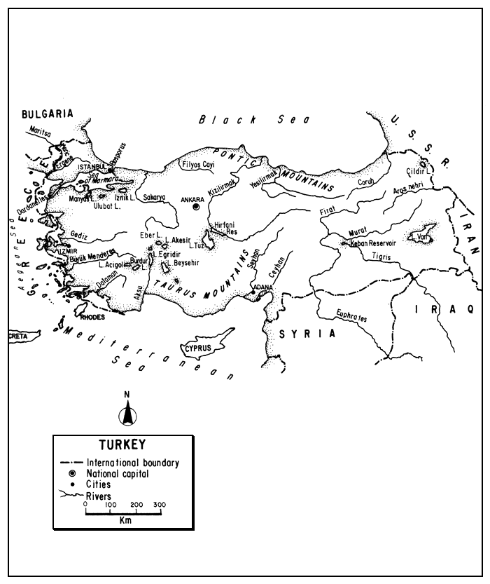
The Republic of Turkey is a passage-land between the Balkans and the Middle East: 3 percent (Thrace) lying in Europe and 97 percent (Anatolia) in Asia. Bounded by six countries, and with a long coastline on the Black, Aegean and Mediterranean Seas, it consists of a narrow coastal belt backed by mountains which enclose a great plateau.
The arid plateau contains numerous lakes, many of which are alkaline and some so saline that they will not support fish. The coasts have a considerable number of lagoons which support traditional fisheries for euryhaline species.
Although primarily agricultural (albeit much of the farming is on poor terrain) Turkey's growing industrialization and urbanization has created demands on its limited water resources, and increased its pollution. With a great need for irrigation, the construction of new reservoirs, which are also used to produce hydroelectric power, has created many new static water fishing areas.
Most of the inland commercial fisheries derive from the lakes and reservoirs on the Anatolian plateau, the remainder is principally from lagoons and other coastal areas. Crayfish, carp, and eel are the major inland fishery exports. Aquaculture is developing slowly, and sport fishing is little developed, although the potentialities are there.
The future for Turkey's inland fisheries is one of expansion which will come about through adoption of more modern methods of capture, processing and transport, investigation and management.
| 1. | AREA: | 779 452 km2 | |
| 2. | POPULATION: | 54 647 000 (est. 1990) | Density: 70 inh/km2 |
| 3. | PHYSICAL GEOGRAPHY | ||
Turkey, situated in the Eastern Mediterranean region, both within Europe and Asia, lies between 35°51' and 42°06'N latitudes and 25°40' and 44°48'E longitudes.
European Turkey, which is called Thrace, holds about 12 percent of the population and has an area of 23 764 km2 (3 percent of the country). Asiatic Turkey, called Anatolia or Asia Minor, has an area of 755 688 km2 (97 percent of the country). The two are separated by the Dardanelles, Sea of Marmara and Straits of the Bosphorus, a route of about 361 km.
Roughly ovate, the country is about 1 750 km (NW-SE) and 670 km wide (NNE-SSW) and has a periphery, including seas and islands, of 11 086 km. The median altitude of Turkey is 1 128 m; the range in elevation is from sea level to 5 166 m, the summit of Mt. Ararat. Of more importance is the fact that in Asiatic Turkey flat or gently sloping land is very rare, and moderately sloping land is limited mainly to Thrace whose highest point is 1 030 m.
The European portion is bordered on the west by Greece for 212 km and on the north by Bulgaria for 269 km. Anatolia is bordered on the east by the USSR for 610 km and Iran for 454 km, and on the south by Iraq for 331 km and Syria for 877 km1.
1 Length of all boundaries from Türkiye Istatistik Yilligi, 1987
The lengths of the coastal boundaries are as follows: Thracian coast 786 km, Anatolian coast 6 480 km, and island coast 1 067 km. The mainland coastlines comprise: 1 695 km on the Black Sea (north), 2 805 km on the Aegean Sea (west), and 1 677 km on the Mediterranean Sea (south). The combined coastline of the Sea of Marmara and its entrance and exit totals 1 169 km.
In general, Turkey consists of a central massif of uplifted blocks and downfaulted troughs (the plateau region), surrounded on all but the west side by a chain of high folded mountains which edge the coastal strips along the Black Sea and Mediterranean. These mountains merge into a mass of jumbled peaks in eastern Turkey close to the USSR and Iran. The mountains act as a barrier to rain-bearing winds leaving the plateau arid. The plateau is treeless, has salt marshes and desert, and becomes less productive as one proceeds eastward. The mountains fall off rapidly to the sea, where they border fertile wooded coastal belts which range from sea level to about 150 m. Part of the great Alpine-Himalayan belt, Turkey is still subject to extensive faulting, making it an earthquake zone.
Turkey consists of five natural regions: the three coastlands, the central plateau, and the eastern highlands1.
(i) Black Sea Coastlands (10 percent). Stretching completely across northern Turkey is a steep and rocky coast below the faulted Pontic Mountains. Most of the strip is a narrow ribbon widening here and there into a fertile delta. Short rivers cascade through gorges in the well-forested mountains, and a few larger ones have cut back into the mountains. The western part of this area is the centre of Turkey's heavy industry.
(ii) Aegean Coastlands (16 percent). Including Thrace and Marmara, and stretching from the Greek border south for 2 805 km, this is mostly rolling plateau country well suited for agriculture. The 60-km Strait of the Dardanelles, averaging 4 km in width, leads inward from the Aegean to the 11 137-km2 sea of Marmara, 80 km at its widest, 247 km long, and 1 327 m deep. This Sea in turn opens to the Black Sea through the 27-km Bosphorus which averages about 1.5 km in width, narrowing to less than 500 m in spots. Both the Dardanelles and the Bosphorus are old river channels drowned by the sea. The Aegean region has fertile soils and typically Mediterranean climate. The lowland contains about one-half of the country's agricultural wealth and is its most densely populated area. The shoreline is greatly indented and the Aegean is studded with islands, mostly Greek.
(iii) Mediterranean Coastlands (8 percent). This southern area has a much more regular coastline than its Aegean counterpart. With warm, subtropical climate and fertile soils, it is rich agriculturally (citrus, cotton, rice, grapes, etc.), but is subject to drought. The backland is mainly karst and the rivers have not cut many valleys to the sea. It has few major cities.
(iv) West and Central Plateau (35 percent). Arid and plateau-like, with elevations ranging from 600 to 1 200 m, west to east, a sub-desert or steppe, ringed by mountains, Central Anatolia is the heartland of Turkey. On the north, the Pontic Mountains, mainly 1 600 to 2 000 m, separate the plateau from the Black Sea region. On the south, the Taurus Mountains, up to about 2 800 m, separate it from the Mediterranean region. The two mountain systems converge in the east in the Eastern Highlands. Wooded areas are confined to the northwest and northeast, and cultivation on infertile soils and with low rainfall is mainly restricted to river valleys. For the most part, the plateau is bare and monotonous with rough terrain and poor soil, used primarily for grazing. Rainfall is limited, the summers are hot, and winters harsh and cold with heavy lasting snows. Although irrigation is practised, the deeply entrenched river courses make it difficult to raise water to the surrounding lands.
(v) Eastern Highlands (31 percent). This is an area of very rugged country with many volcanic peaks rising to 3 000–5 000 m. It is also the Turkish area with the severest climate (down to -40°C), and having more rain than the Central Plateau. Although it contains some fertile basins and river corridors at the foot of lofty ranges, much of it is a wild, barren wasteland with a sparse population, some of it nomadic. Hydrographically, it is notable in being the headwaters of the famed Tigris and Euphrates rivers.
About 40 percent of Turkey's soils are acidic red and grey-brown podsols and brown forest soils found mainly in mountain areas. Brown and reddish steppe soils (20 percent) and large saline areas are found on the plateau. About 40 percent of the soils are terra rossas, alluvial, and bare rock. Some areas are covered with recent lava flows. More productive soils comprising clay and lime materials underlain by sand-silt and clay are found in coastal and lowland areas such as European Turkey. The richest soils are found on alluvial plains in the wider valleys and in volcanic regions, but soils fertility is generally low, and about 20 percent of Turkey's soils are considered non-arable. Most Turkish soils are deficient in organic matter and plant nutrients and have been harmed by centuries of deforestation, over-grazing, and erosion.
The original vegetative cover in Turkey has been greatly modified by man. Basically, there are four types:
Settlements are heavily concentrated in European Turkey and in the fertile valleys of the Marmara, Aegean and Black Sea coasts. Thrace alone has about 12 percent of the population.
4. CLIMATE
Most of Turkey's climate is a dry semi-continental variation of the Mediterranean type, or alternatively is transitional between Mediterranean and temperate continental regimes. Coastal Turkey has mild wet winters and moderately hot summers. The interior plateau has a wide range of temperatures with hot summers and severe winters, as has the inhospitable eastern part of the country.
The mean annual temperature varies from about 20°C on the south coast (11–29°C), falls to about 15°C on the west and Black Sea coasts (7–23°C), and in the interior varies between 4° and 18°C. In summer, all but the higher mountain areas are hot. July means are above 20°C for the whole country, rising above 25°C in western and central Anatolia, and above 30°C in the southeast where over 40°C has been recorded. In winter, the means are between 0° and -10°C in the interior becoming much colder toward the east. Extreme minima in the interior vary from -20°C in the west and -40°C in the east. The peripheral coasts have January means above 5°C.
The average annual rainfall is about 670 mm, but varies in each region with a minimum of 63 mm and maximum of 4 045 mm. The highest rainfall generally occurs on the slopes of the mountains facing the sea, with 1 000–1 500 mm annually on the Aegean slopes and over 2 500 mm on the eastern Black Sea slopes. Rainfall is about 200 mm at lower coastal levels. In the central and southwest interior, the rainfall averages 300–400 mm. The Black Sea coast receives rain throughout the year. On the other coasts, the rainy season starts in autumn and continues until spring. In the interior and southeast, rain occurs mainly in the spring.
The western continental area does not experience much frost, but it may occur more than 200 days annually in parts of the interior plateau. On an average, the number of days with frost varies from 13 to 16 on the west and south coasts and 103 to 107 on the eastern Central Plateau. Prolonged snowfall is typical of the interior and snow may last for four months in the higher east.
5. HYDROGRAPHY AND LIMNOLOGY
According to the source of Table 8, the extent of inland water in Turkey is 9 820 km2 or almost 1.3 percent of the country's total area. Another estimate is 9 243 km2 or 1.2 percent of the total area (Encyclopedia Britannica, 1974). Far surpassing both of these estimates is one made by FAO/World Bank (1975) which says that “Turkey has large extensions of inland waters as follows”:
| No. | Area (ha) | |
| Natural lakes | 42 | 925 000 |
| Dam reservoirsa | 62 | 175 000 |
| Lagoons | 66 000 | |
| Paddy fields | 65 000 | |
| Rivers | 148 000 km | 60 000 |
| Ponds | 560 | |
| 1 291 560 |
a Including those under construction
The derivation of most of the above figures appears to be as follows: lakes (over 10 km2), lagoons, rivers, and ponds from TUMAS (1972); dam reservoirs include only those owned by the State Hydraulic Department. Such an estimate would be about 1.6 percent of Turkey's total area, but if we include only the estimates of areas of natural lakes and rivers, which total 9 850 km2, the estimate is more in line with the others, i.e., only 1.3 percent of the total area. Turkey/EIFAC (1989), basing its statement on DSI, 1989. Türkiye eki Barajlar ve Hidroclektrik Santrallar, increases the FAO/World Bank (1975) figures to a total inland water area of 1 508 072 ha by saying that there are 183 dam reservoirs with an area of 391 512 ha. Specific remarks on some of these components of “inland waters” will be made below, particularly the fact that the lake area cited contains much saline water, which in some cases will not support any fish life, and in others almost no species of economic importance.
The approximate annual runoff from rainfall for the entire country is 167 thousand million m3, but after use and evaporation there is a runoff to the oceans of 143 thousand million m3 (Noyen et al., 1967, in Van der Leeden, 1975). In the European portion of Turkey alone, the annual runoff from rainfall is 3 300 million m3 with 6 800 million m3 entering the country, the total runoff leaving Thrace is 9 100 million m3 (Van der Leeden, 1975).
Turkey has four major drainages: Atlantic (Mediterranean), Caspian Sea, Indian Ocean, and interior (see section 5.1). These can be further divided into 26 major river basins as shown in Table 1 which shows their area, main precipitation, runoff and discharge.
Table 1
Turkish water resources by river basins
| River basin | Area | Mean precipt | Available surface water resources | |||
| km2 | mm | 109m3a | mm | m3/s | l/s/km2 | |
| Meric-Ergene | 14 560 | 500 | 1.06 | 72.5 | 33.5 | 2.3 |
| Marmara | 24 100 | 800 | 5.85 | 242.6 | 185.6 | 7.7 |
| Susurluk | 22 399 | 600 | 4.16 | 185.9 | 132.0 | 5.9 |
| North Aegean | 10 003 | 650 | 1.74 | 173.2 | 55.2 | 5.5 |
| Gediz | 18 000 | 600 | 2.27 | 126.0 | 72.0 | 4.0 |
| K.Menderes | 6 907 | 650 | 1.04 | 151.2 | 33.15 | 4.8 |
| B.Menderes | 24 976 | 600 | 3.15 | 126.0 | 100.0 | 4.0 |
| W. Mediterranean | 20 953 | 900 | 6.86 | 327.6 | 217.0 | 10.4 |
| Antalya | 19 577 | 1 100 | 14.33 | 491.4 | 454.9 | 23.2 |
| Burdur Lakes | 6 374 | 600 | 0.9 | 141.8 | 28.7 | 4.5 |
| Akarcay | 7 605 | 500 | 0.91 | 119.7 | 28.9 | 3.8 |
| Sakarya | 58 160 | 450 | 4.1 | 69.3 | 130.0 | 2.2 |
| W. Black Sea | 29 598 | 800 | 9.32 | 315.0 | 296.0 | 10.0 |
| Yesilirmak | 36 144 | 500 | 4.57 | 126.0 | 145.0 | 4.0 |
| Kizilirmak | 78 180 | 400 | 5.66 | 72.5 | 179.8 | 2.3 |
| Int.basin Konya | 53 850 | 400 | 3.91 | 72.5 | 124.0 | 2.3 |
| E. Mediterranean | 22 048 | 900 | 9.03 | 409.5 | 286.6 | 13.0 |
| Seyhan | 20 450 | 880 | 5.92 | 289.8 | 187.9 | 9.2 |
| Asi | 7 796 | 900 | 1.47 | 189.0 | 46.8 | 6.0 |
| Ceyhan | 21 982 | 950 | 7.25 | 330.8 | 230.0 | 10.5 |
| Euphrates (Firat) | 125 540 | 700 | 28.35 | 220.5 | 900.0 | 7.0 |
| E.Black Sea | 24 077 | 1 400 | 11.34 | 469.4 | 360.0 | 14.9 |
| Coruh | 19 872 | 600 | 4.88 | 245.7 | 155.0 | 7.8 |
| Aras | 27 548 | 500 | 3.71 | 207.9 | 181.38 | 6.6 |
| Int. basin Van | 19 405 | 700 | 3.54 | 182.7 | 113.0 | 5.8 |
| Tigris (Dicle) | 57 614 | 850 | 19.49 | 337.0 | 618.8 | 10.7 |
| Total | 777 688 | 670 | 166.81 | 214.0 | 5 300.0 | 6.8 |
a One thousand million cubic metres
Source: Van der Leeden (1975) after Cecen, Wasser und Boden (1968)
5.1 Rivers1
The total length of Turkey's rivers is about 148 000 km with an estimated area of about 60 000 ha (TUMAS, 1972). Petr (1983) says that 33 major rivers in Turkey cover 175 715 ha; this is probably a lapsus calamus and km should be substituted for ha.
The major rivers of the country are listed under their respective river basins in Table 2. The seasonal discharge of some of the country's major rivers is shown in Table 3.
1 In Turkish, akarsu, irmak and nehrir are words for river. Cay and su are words for smaller streams
Table 2
Some principal rivers of Turkey
| Basin and River | Length (km) | |||
| Black Sea (W to E) | Within Turkey | Outside Turkey | ||
| Sakarya | 824 | |||
| Porsuk cayi | 488 | |||
| Ankara cayi | 186 | |||
| Aladag cayi | 139 | |||
| Göksu | 118 | |||
| Filyos cayi (Yenice irmagi) | 228 | |||
| Gerede cayi | 260 | |||
| Arac cayi | 119 | |||
| Kisilirmak | 1 355 | |||
| Delice irmagi | 426 | |||
| Devrez cayi | 186 | |||
| Gökirmak | 221 | |||
| Yesilirmak | 519 | |||
| Çecerek cayi | 331 | |||
| Kelkit cayi | 373 | |||
| Coruh | 442 | |||
| Oltu cayi | 151 | |||
| Sea of Marmara | ||||
| Susurluk (Simav) cayi | 321 | |||
| Kocabas cayi | 108 | |||
| Gonen cayi | 134 | |||
| Aegean Sea (N to S) | ||||
| Meric | 211 | 279 | ||
| Ergene | 281 | |||
| Gediz | 401 | |||
| Alasehir cayi | 115 | |||
| Gordes cayi | 152 | |||
| Kücük Menderes | 175 | |||
| Büyük Menderes | 584 | |||
| Akçay | 157 | |||
| Sag Menderes | 185 | |||
| Sol Menderes | 88 | |||
| Cine cayi | 99 | |||
| Dalaman | 229 | |||
| Mediterranean Sea (W to E) | ||||
| Aksu cayi | 162 | |||
| Göksu nehri | 308 | |||
| Seyhan | 560 | |||
| Göksu | 201 | |||
| Zamanti suyu | 308 | |||
| Ceyhan | 509 | |||
| Goksu | 138 | |||
| Asi nehri (Orantes) | 97 | 283 | ||
| Persian/Arabian Gulf (W to E) | ||||
| Euphrates (Firat) | 971 | 1 829 | ||
| Çalti suyu | 143 | |||
| Murat nehri | 722 | |||
| Munzur suyu | 144 | |||
| Tigris (Dicle) | 523 | 1 377 | ||
| Batman cayi | 170 | |||
| Garzan cayi | 122 | |||
| Ulucay (Botan cayi) | 268 | |||
| Caspian Sea | ||||
| Aras nehri | 548 | 511 | ||
| Arpaçay | 174 | |||
Source: Primarily from Türkiye Istatistik Yilligi, 1987
Table 3
Discharge of five principal rivers in Turkey
| Sakarya | Kizilirmak | Euphrates (Firat) | Büyük Menderes | Ceyhan | |
| Basin area km2 | 5 320 | 75 120 | 63 835 | 23 889 | 19 767 |
| Mean monthly discharge, m3/s | |||||
| January | 242 | 174 | 308 | 167 | 265 |
| February | 328 | 234 | 380 | 190 | 324 |
| March | 350 | 308 | 723 | 168 | 421 |
| April | 354 | 260 | 1 990 | 124 | 446 |
| May | 273 | 190 | 1 780 | 83.7 | 326 |
| June | 162 | 172 | 792 | 53.7 | 153 |
| July | 101 | 89.5 | 361 | 28.1 | 66.9 |
| August | 73.8 | 62.0 | 246 | 23.8 | 47.6 |
| September | 92.1 | 87.1 | 217 | 31.6 | 48.3 |
| October | 115 | 98.9 | 248 | 38.9 | 61.2 |
| November | 123 | 97.7 | 300 | 67.7 | 70.9 |
| December | 213 | 132 | 304 | 103 | 265 |
| Year | 202 | 159 | 639 | 90.0 | 199 |
| Period of record | 1961–66 | 1962–66 | 1937–66 | 1951–66 | 1954–66 |
Source: Unesco (1969)
A major divide between Turkey's river basins runs obliquely through eastern Anatolia separating the Atlantic (Mediterranean) drainage from that of the Indian Ocean and Caspian. East of this divide, a large area drains through Iraq to the Persian Gulf through the two greatest rivers of Western Asia, the Euphrates (Firat) and Tigris (Dicle) rivers; and a smaller eastern area drains to the Caspian Sea through the Kuracay and Aras rivers. (The later forms part of the border between Turkey and the USSR.) There are also two areas of interior drainage comprising about one-seventh of the country: (i) the Lake Van drainage, and (ii) drainages from the southern part of Central Anatolia and adjacent sectors of the Taurus Mountains (Konya Drainage). Most of Turkey's drainage is, however, Mediterranean, either directly in the the Sea or into its component, the Aegean, or circuitously through the Black Sea and Sea of Marmara.
Notes on the major rivers of Turkey follow:
Black Sea drainage: The country west and north of the main divide drains to the Black Sea, principally (west to east) through the following rivers: Sakarya, Filyos (Yenice), Kizilirmak (Halys), Yesilirmak (Iris), and Coruh which passes through the USSR to the Black Sea. Most of the Black Sea coast is steep, often with cliffs, backed by wooded mountains except for short torrential streams. The Kizilirmak, the longest river entirely in Turkey, runs in a great arc generally southwesterly and then northeasterly to the Sea. It and the Yesilirmak bear heavy silt loads which have built up deltas in the sea, and the Sakarya has a large alluvial plain.
Aegean drainage: The Thracian boundary with Greece follows the Meric River, the largest river in European Turkey, for 211 km. Originating in Bulgaria as the Maritza it is called the Evros in Greece and discharges into the Aegean Sea in the Gulf of Enez, with lagoons at its mouth. Flood control on the Meric has necessitated the exchange of land with Greece to strengthen flood control. The main tributary of the Meric is the Ergene flowing from east to west across Thrace and constituting its major basin. The northern part of the Aegean shore is drained mainly by inconspicuous torrents, but from just north of Izmir (Smyrna) proceeding south, there are some larger leisurely rivers: the Gediz (Hermus), Kuçuk (or lesser) Menderes, Büyük (or greater) Menderes, which gave the word “meander” to the English language, and then the Dalaman, the most westerly of the Taurus streams.
Sea of Marmara drainage: Streams emptying into this Sea mostly follow direct channels with gentle gradients from source to coast, although some streams first enter coastal lake or swamp areas. The Susurlak (Simav or Macertus) is the Sea's principal river.
Mediterranean drainage: The principal Mediterranean rivers are the: Aksu cayi or outlet of Egirdir Lake, Göksu (Calycadnas) which picks up much of the drainage from the Taurus slopes south of the lake district, the deeply incised Seyhan or Sarus, and the Ceyhan (Pyramus) which have large deltas, and the lower course of the Asi (Orantes) which originates in Syria.
Persian Gulf drainage: The Euphrates, known in Turkey as the Firat, is formed in East Central Turkey by the junction of the 460-km Western Euphrates or Kara Su and the 722-km Murat which rises southwest of Mt. Ararat. The combined streams flow 511 km to the Syrian border and thence through Iraq to join with the Tigris in the Shatt al Arab which flows 193 km farther to the head of the Persian or Arabian Gulf. The Tigris, known in Turkey as the Dicle, rises in Gölcük, a mountain lake in East Central Turkey, flows southeast, forming about 32 km of the Syrian border before entering Iraq, after 523 km in Turkey, and finally joining with the Euphrates, a total length of 1 900 km.
Caspian Sea drainage: Both the Kuraçay and the Aras nehri rivers drain eastward to the Caspian Sea. The latter river flows eastward from Bingol Mt. for 548 km to the USSR boundary and forms part of it. Meanwhile it is joined by the Arpa cayi, the outlet of Cildir Lake. Its entire course is 1 059 km.
Compared with the rest of the Middle East, Turkey has a considerable number of streams, but considering its size it is not rich in rivers, and those other than the Tigris and Euphrates are relatively small.
Except for the Black Sea Coastal area, precipitation is unevenly distributed throughout the year. As a consequence of this factor as well as their usually barren watersheds, many Turkish rivers frequently flood in spring and become reduced to stagnant ponded beds in the autumn. The rivers of southern Anatolia, which receive little rain, are made even dryer by the porous limestone surface that permits rapid percolation.
5.2 Lakes (Göller)
The country's irregular topography has given rise to many lakes, some fresh and some saline. Official statistics in 1960 listed 61 natural lakes which had been surveyed in Turkey as having a total area of 9 061.18 km2. TUMAS (1972) lists 46 natural lakes having a surface area of over 10 km2 which have a total area of 9 257 km2, and FAO/World Bank (1975) states that there are 42 lakes with a total area of 9 250 km2. In both cases, it is known that a number of the lakes included in the summary are “salt” lakes.
Table 4, based on up-to-date Turkish statistics, lists 48 Turkish lakes with a surface area of 5 km2 or over, having a combined area of 8 903 km2. Again it is known that some of these are “salt” lakes and some of them are better classed as “lagoons” rather than lakes (see section 5.5).
Petr (1983) states that Turkey has some 200 larger natural lakes covering 9 061.18 km2, and that there are also a number of inland salt lakes. One might judge from his statement that the 200 natural lakes were freshwater. However, one should note that his figure for their area is identical with the Turkish statistics of 1960 for 61 Turkish lakes and that it is definitely known that the latter included salt lakes.
It is apparent that the preceeding statistics are misleading from the standpoint of judging fish production in Turkey, since some of the lakes contain such large quantitites of salts such as NaCL, Na2CO3, or MgSO4, that they cannot support fish life. For example, Tuz Gölu, which is listed by TUMAS (1972) and following it by FAO/World Bank (1975) and also in the 1981 source for Table 4, is a salt lake, with an area of about 1 500 km2 and a depth of less than 1 m, which does not support fish. Aksiray (1961) says that the number of Turkish lakes where fish life cannot be supported total 6 363.9 km2.
Under the circumstances, until the subject is better clarified, I return to the 1960 statistics which said there were 2 048.94 km2 of inland lakes capable of supporting fish life plus 6 483.4 km2 of shore lakes or lagoons, i.e., static waters having a connection with sea. Turkey/EIFAC (1977) indicated that static waters capable of supporting fish life could be grouped into about 2 900 km2 of inland lakes and 660 km2 of lagoons.
Although the largest lake in European Turkey is the 25-km2 Terkos, most Turkish lakes are situated in the western half of Anatolia. There is a group of larger lakes, including the shallow coastal lakes of Kus and Ulubat and the deep low-altitude lake of Isnik, just south of the Sea of Marmara. Farther inland on the Plateau there is an extensive “lake district” including heavily saline lakes such as Burdur (200 km2) and Aegol or Bitter Lake (153 km2), the remains of the Tuz Gölu, and lakes with fresher water which support economic fisheries. Among the latter are: the largest truly freshwater lake in Turkey, Beysehir (656 km2), and the second, third and seventh freshwater lakes, Egridir, Aksehir and Eber, respectively. Far to the east at an altitude of 1 646 m is Lake Van, the largest lake in Turkey (3 713 km2), and another large high-altitude lake, Cildir, at 1 969 m in the extreme northeast.
The general limnological character of the nine largest natural lakes in Turkey (all over 100 km2 in extent) which support fisheries are shown in Table 5.
As has been pointed out, many of the Turkish lakes, especially those lying on the Anatolian Plateau are characterized by high alkalinity and are rich in dissolved solids. Of such lakes that support fish, Lake Van can be taken as an extreme example. With its own interior drainage, a basin of 19 405 km2, with no outlet, its waters are heavily sodium-carbonated. Only one species of fish, a bleak, the bleak or inci kefali (Chalcarburnus tarichi) is reported to live in the lake, and here only in the mouths of its tributaries or in areas around underground springs. This cyprinid is caught during the upstream migration in the spring. It is used fresh or salted and its eggs made into caviar. Production reported in 1971 was 2 100 t (FAO/World Bank, 1976). Another lake, the 676-km2 Beysehir, often called the largest freshwater lake in Turkey, is also saline, but supports several species of economically valuable fish: common carp (Cyprinus carpio), various other cyprinids, especially Alburnus sp. and the chub Leuciscus cephalus, pike-perch (Stizostedion lucioperca), and the crayfish (Astacus leptodactylus). Yields are low (see section 9.1), but there are active fisheries. Egridir, the second largest freshwater lake, also in the “lake district”, is also high in dissolved solids, but supports crayfish, the introduced pike-perch, common carp, and Vimba vimba. Aksehir also in the Plateau's lake district, has exceptionally high conductivity, is rich in reed beds (especially Phragmites) which is used commercially, and has fish of economic importance including crayfish, common carp, and pike (Esox lucius), in this order. Eber Lake, just northwest of Aksehir, is an example of a large (126 km2) shallow (5 m) lake with much aquatic vegetation, both emergent and submergent, and high load of dissolved solids, but also with a high yield of economically valuable fishes. In 1980, the catch of just three species (pike, crayfish and carp) was 118.5 t, a yield from the free-water area alone (37.8 km2) of 31.3 kg/ha/year.
In addition to these plateau lakes, Turkey has a number of lowland lakes which are close to lagoons in physical attributes, and being open to the sea may have faunal elements such as pipefishes (Syngnathidae), clupeids (e.g., Clupeonella), gobies, and migrating eels (Anguilla anguilla). In fact, Table 4 includes a number of lakes classified by the Turkish Government as “natural lakes” which might better be termed “lagoons” (see section 5.5).
Among these shallow coastal lakes are Kus (Manyas) near the sea of Marmara, which with an area of 166 km2 is the fifth largest freshwater lake in Turkey. Carp dominate the catch, followed by crayfish, pike, European catfish (Silurus glanis) and various cyprinids. Nine cooperatives of about 800 fishermen use gillnets, beach seines and crayfish traps in the fishery. Another shallow coastal lake near Marmara is the 134-km2 Ulubat (Apolyont) only 5 m above sea level, with a diverse fauna of freshwater and brackishwater forms. In 1981 it produced a catch of 1 405 t, primarily of crayfish, carp and pike, which dropped to 679 t in 1982.
Also near the Sea of Marmara, but of a quite different type is the Lake of Isnik, the fourth largest freshwater lake (298 km2) in Turkey, situated at an altitude of 85 m. Like so many Turkish lakes, it is alkaline but since it is deep (90 m) it has low water temperatures at depth. Its natural fauna is one of crayfish, cyprinids and European catfish, but it has also been considered to be suitable for coregonids (Coregonus sp.) (see section 7).
In addition to these lakes, which are primarily cyprinid in character, there are Turkish lakes of a more oligotrophic character which can support trout (Salmo trutta) populations. Some of these at low altitudes are deep, e.g., Abant. The crater lake of Gölcük, 35 m deep at 1 300 m, also supports trout, and one of the largest trout waters is Cildir Lake (125 km2) situated in the Aras River drainage in the extreme northeastern area of Anatolia. Although it has an average depth of only 13 m it lies at 1 925 m and is fed by many small rivers and springs. Said not to exceed 21°C at the surface and to be iced over for three months, it supports brown trout (Salmo trutta), as well as carp and karabalik or Vimba vimba. Trammel nets are used for the trout, gillnets for the carp, and lines are used for winter ice-fishing. Total fish production is about 120 t annually or a yield of 9.6 kg/ha/year.
5.3 Reservoirs (Barajlar, baraj gölleri or göletler)
In 1975 there were reported to be 154 700 ha of dams and artificial lakes by UNDP/FAO (1975). In 1978, a total of 69 large dams (over 15 m in height) were reported in Turkey (CIGB/ICOLD, 1979). In terms of such dams, this accorded Turkey a rank of twelfth highest in Europe and twenty-third in the world. The FAO/World Bank (1975) reported 62 reservoirs owned by the State Hydraulic Works Department with a water surface of 174 515 ha of reservoirs and dams. Petr (1983) stated that there were 74 large reservoirs in Turkey with an estimated area of 185 000 ha. Turkey/EIFAC (1989) states that, according to DSI (1989) Türkiye deki Barajlar ve Hidroelektrik Santrallar, Turkey had 183 reservoirs with a total area of 391 512 ha by the end of 1988. A map issued in 1989 by the same group shows approximately 112 reservoirs in operation, 65 under construction and 74 in the planning stage.
Table 6 shows the official Turkish figures for 1987 on the principal reservoirs in Turkey: 36 with a surface area of 5 km2 and over, totalling 1 645.1 km2 in area.
In addition to the large reservoirs, there are many small reservoirs or ponds. Circa 1972, 77 ponds (ranging from 0.1 to 51.5 ha) had been constructed by the General Directorate of Forestry (TUMAS, 1972). Petr (1983) stated that there were 350 small reservoirs with an area of 9 000 ha, but also stated that there were about 600 smaller reservoirs (dams).
The largest reservoirs in Turkey listed above is Keban, formed by a 207-m rockfill gravity dam on the Euphrates (Firat) and its tributary the Murat. When completed in 1974, its hydroelectric plant doubled the electrical capacity of Ankara and Istanbul. The reservoir has an area of 675 km2, a maximum depth of 167 m, average depth of 40 m, and volume of 31 thousand million m3. Water temperatures vary from 4° to 21°C with a bottom temperature constant at 8.5°C. Keban has a native cyprinid fauna, plus European catfish, brown trout and several species of Asian catfishes (Mystus sp. and Glyptothorax sp.) and spiny eels (Mastacembelus). The second largest operating reservoir in Turkey is Hirfani, also on the Plateau but on the Kisilirmak River tributary to the Black Sea. With an area of 263 km2, it has a volume of 6 thousand million m3.
Table 4
Principal “natural lakes” (5 km2 and over in area) in Turkeya
| Lake | Area km2 | Altitude m | Province |
| Acigöl | 153 | 836 | A. Karahisar-Denizli |
| Akdogan | 11 | 2 153 | Erzurum |
| Aksehir | 353 | 958 | A. Karahisar-Konya |
| Akyatan (Bati) | 35 | 4 | Adana |
| Akyatan (Dogu) | 15 | 0 | Adana |
| Amik | 60 | 81 | Hatay |
| Arin | 13 | 1 658 | Bitlis |
| Avlan | 8 | 1 024 | Antalya |
| Bafa | 60 | 2 | Aydin-Mugla |
| Balik | 34 | 2 250 | Agn |
| Balik-Uzun | 12 | 0 | Samsun |
| Beysehir | 656 | 1 121 | Isparta-Konya |
| Boluk (Acituz) | 11 | 940 | Konya |
| Burdur | 200 | 854 | Burdur |
| Büyükcekmece | 11 | 0 | Istanbul |
| Cavuslu | 9 | 1 019 | Konya |
| Cildir | 115 | 1 959 | Kars |
| Colgolu | 32 | 1072 | Kayseri |
| Dil (Karine) | 24 | 0 | Izmir |
| Düdengölü | 8 | 961 | Konya |
| Eber | 126 | 967 | A. Karahiser |
| Egridir | 468 | 916 | Isparta |
| Ercek | 98 | 1 803 | Van |
| Gala | 8 | 10 | Edirne |
| Hacli | 16 | 1 583 | Mus |
| Hazapin | 14 | 1 794 | Kars |
| Hazar | 86 | 1 248 | Elazig |
| Iznik | 298 | 85 | Bursa |
| Isikli | 49 | 816 | Denizli |
| Karatas | 6 | 1043 | Burdur |
| Kestel | 25 | 779 | Burdur |
| Köycegiz | 52 | 8 | Mugla |
| Kus (Manyas) | 166 | 15 | Balikesir |
| Kücükcekmece | 16 | 3 | Istanbul |
| Marmara | 34 | 71 | Manisa |
| Mogan | 6 | 972 | Ankara |
| Nazik | 48 | 1 816 | Bitlis |
| Nemrut | 12 | 2 247 | Bitlis |
| Salda | 45 | 1 139 | Burdur |
| Sapanca | 47 | 40 | Kocaeli |
| Seyfe | 15 | 1 110 | Kirsehir |
| Terkos | 25 | 5 | Istanbul |
| Tuz | 1 500 | 925 | Konya-Nigde |
| Tuzla | 23 | 1 138 | Kayseri |
| Ulubat | 134 | 5 | Bursa |
| Van | 3 713 | 1 646 | Bitlis-Van |
| Yarisli | 16 | 950 | Burdur |
| Yay | 37 | 1 071 | Kayseri |
a Some of these at low elevation are better classed as lagoons (see section .5.).
Source: Türkiye Istatistik Yilligi, 1987
Table 5
Limnological data for the nine largest Turkish lakes with fisheries
| Van | Beysehir | Egirdir | Aksehir | Isnik | Kus (Manyas) | Ulubat (Apolyont) | Eber | Cildir | ||
| Area (km2) | 3 713 | 676 | 468 | 353 | 298 | 166 | 134 | 126 | 115 | |
| Elevation (m) | 1 646 | 1 121 | 916 | 958 | 85 | 15 | 5 | 907 | 1 959 | |
| Depth (m) | ||||||||||
Maximum | 90 | a | 10 | 16 | 5 | 90 | - | 2–7.5 | 5 | 22 |
Mean | - | - | 6.7 | 3 | - | 2 | 2–7.5 | - | 13 | |
| Conductivity uS cm-1 | - | 297–321 | - | 2 330 | - | - | 19.6–56.8 | 434 | - | |
| pH | - | 8.9 | 7.2 | 8.4–9.6 | 8.4 | 7.7 | 8.0–8.2 | 6.9–8.7 | - | |
| Oxygen (mg/1) | - | 8.1–8.3 | 8.0 | 7.6–8.1 | 10.4 | 10.5 | 9.0–9.6 | - | - | |
| Temperature (°C) | - | - | 12.7 (av.) | 25 (max) | 24 (summer) | 25 (max) | - | - | 21 (max) | |
| Total hardness, CaCO3 (mg/1) | - | - | 21.19 | 33–58 | 327 | 142 | 230–279 | - | - | |
a USSR (1978) says that Lake Van is 145 m deep
Source: Table 4 for areas and elevations
FAO/World Bank (1976a) for Cildir and Egirdir
Petr (1983) for all except Cildir
Table 6
Principal reservoirs (5 km2 and over in area) in Turkey
| Reservoir | Area km2 | Province |
| Afsar | 5.3 | Manisa |
| Almus | 31.3 | Tokat |
| Apa | 12.6 | Konya |
| Arpacay | 41.8 | Kars |
| Aslantas | 49.0 | Adana |
| Berdan | 6.7 | Icel |
| Büyük Cekmece | 43.0 | Istanbul |
| Caygören | 7.3 | Bahkesir |
| Camlidere | 32.0 | Ankara |
| Demirköprü | 47.7 | Manisa |
| Devegecidi | 32.1 | Diyarbakir |
| Gökcekaya | 20.0 | Eskisehir |
| Güzelhisar | 5.8 | Izmir |
| Hasan Ugurlu | 22.7 | Samsun |
| Hirfanli | 263.0 | Kirsehir |
| Kadiköy | 8.0 | Edirne |
| Karaidemir | 15.0 | Tekirdag |
| Kartalkaya | 11.3 | K. Maras |
| Kayaliköy | 10.2 | Kirklareli |
| Keban | 675.0 | Elazig |
| Kemer | 14.8 | Aydin |
| Kesikköprü | 6.5 | Ankara |
| Kozan | 6.2 | Adana |
| Kurtbogazi | 5.0 | Ankara |
| Mamasin | 11.7 | Nigde |
| May | 7.8 | Konya |
| Omerli | 23.1 | Istanbul |
| Porsuk | 23.4 | Eskisehir |
| Sanyar | 83.8 | Ankara |
| Selevir | 5.0 | A. Karahisar |
| Sevisler | 6.1 | Manisa |
| Seyhan | 67.8 | Adana |
| Suat Ugurlu | 9.7 | Samsun |
| Sürgü | 5.1 | Malatya |
| Tahtaköprü | 23.4 | Gaziantep |
| Yedikir | 5.9 | Amasya |
Source: Türkiye Istatistik Yilligi, 1987
However, the new Ataturk Dam on the Euphrates, scheduled to start power production in May 1991, will have an area of about 815 km2. Its closure in January 1990 caused the flow to be reduced in both Syria and Iraq. It is part of the Southeast Anatolia project which will harness the waters of both the Euphrates and Tigris with a series of 12 dams and 13 hydroelectric plants. Scheduled for completion in 2006, this project will not only increase hydroelectric production in Turkey, but will irrigate about 1.6 million ha through thousands of kilometres of irrigation canals. (San Francisco Chronicle, 13–14 January 1990.)
New reservoirs in Turkey are multi-purpose, constructed both for irrigation and the production of hydroelectric power. The need for reservoirs for irrigation is unquestioned, and the potential for their further development remains high.
5.4 Canals
There are no navigation canals in Turkey, but there are many kilometres of irrigation canals which may contain fish. They will increase in number.
5.5 Lagoons
As in other sections of this review (see especially Italy and Greece for details), the term lagoon refers to a coastal body of water in permanent or intermittent connection with the sea by either natural or artificial means. Lagoons are mostly shallow and contain mixohaline or brackish water and are usually quite productive biologically. In the Mediterranean area, lagoons characteristically have a mixed population of brackish or euryhaline fishes which enter in the spring and attempt to return to the sea in autumn. Where considerable fresh water enters the lagoon, it may have a permanent population of fluvial fishes. Man has taken advantage of this natural inward migration by cutting off the exit of the migrants during the time of growth, and trapping or otherwise harvesting the fish when they attempt to return to the sea as the season cools. Although this process is often termed “lagoon culture”, it is generally merely a form of capture fishery facilitated by the erection of fixed traps or bordigues.
FAO/World Bank (1975) states that Turkey has 66 000 ha of lagoons. Kiener (1978) states that there are 19 lagoons in Turkey totalling 36 520 ha.
Table 7 gives the name and general location of 19 principal lagoons in Turkey totalling 41 514 ha. Both Amanieu and Lassere (1981) and Kapetsky (1984) are in general agreement as to the areas and yields (differences are indicated in the table).
Most of the catch statistics shown in Table 7 are rather old, and, as is well known, many inland fishery catch statistics, particularly those of lagoons, are suspect (see the review of Greece).
Table 7
Ninteen principal lagoons in Turkey
| Finfish annual production/yield | ||||
| Lagoon | Area ha | Calculated total kg | Yield kg/ha | References |
| Black Sea Area | ||||
Karabogaz/Tuzlu/Liman/Balik | 3 726 | 201 204 | 54 | Uyguner and Gozenalp (1959) |
| Koca | 355 | 40 115 | 113 | Uyguner and Gozenalp (1959) |
| Aegean Sea Area | ||||
Güllük | 259 | - | - | Amanieu and Lassere (1981) |
Bafa | 6 581 | 177 687 | 27 | Uyguner and Gozenalp (1959) |
Karine | 2 867 | 40 138 | 14 | Uyguner and Gozenalp (1959) |
Homaa | 6 000 | 78 000 | 13 | Cataudella (1983) |
Pamuklu/Gala/Dalyan/Bücürmeneb | 1 533 | 249 879 | 163 | Cataudella (1983) |
| Marmara Area | ||||
Tuzlu Azmak/Hoyrat/Tahir | 297 | 19 899 | 67 | Cataudella (1983) |
Poyrazc | 303 | 19 998 | 66 | Amanieu and Lasserre (1981) |
Büyük Cekmeceb | 1 073 | 69 745 | 65 | Uyguner and Gozenalp (1959) |
Kücük Cekmeceb | 1 522 | 15 220 | 10 | Uyguner and Gozenalp (1959) |
Tuzla | 95 | 15 010 | 158 | Uyguner and Gozenalp (1959) |
Hersek | 164 | 40 016 | 244 | Uyguner and Gozenalp (1959) |
| Rhodes (Mediterranean) Area | ||||
Ova | 1 412 | 19 768 | 14 | Uyguner and Gozenalp (1959) |
Köycegiz | 5 500 | 324 500 | 59 | Cataudella (1983) |
| Adana (Mediterranean) Area | ||||
Yumurtalik/Yelkoma/Bogazi | 2 833 | 31 163 | 11 | Uyguner and Gozenalp (1959) |
Karatas/Akyatan | 4 694 | 98 574 | 21 | Uyguner and Gozenalp (1959) |
Tuz | 1 102 | - | - | Amanieu and Lasserre (1981) |
Paradeniz | 1 198 | 20 366 | 17 | Uyguner and Gozenalp (1959) |
a Amanieu and Lasserre (1981) stated that Homa had an area of 1 415 ha and a yield of 35 kg/ha/year
b Yield includes both freshwater and marine fishes according to Amanieu and Lasserre (1981)
c Probably synonymous with the Arap-Ciftligi of Kiener (1978)
Source: All areas, yields and the references, except those for Güllük, Poyraz and Tuz, taken from Kapetsky (1984). Locations from Amanieu and Lasserre (1981) and Kiener (1978).
Some of the most recent information on two Turkish lagoons from Cataudella and Ferlin (1984) follows. The Lagoon of Homa with an area of 6 000 ha and a maximum depth of 1 m connects with the sea through eight channels and a large channel equipped with a fixed installation or bordigue of reeds. Its salinity is about 25–35 ppt with a maximum of 40 ppt in summer, and water temperature ranging from 9°C in the winter to 26°C in the summer. The channel is open from February to June to provide entry of fish from the sea. Annual production, in what is essentially a capture fishery, is about as follows: topenkefal (Mugil cephalus), 20 t; other grey mullets (Liza spp. and Chelon labrosus), 30 t; gilthead (Sparus auratus), 25 t; sea bass (Dicentrarchus labrax), 7 t; yilan or European eel (Anguilla anguilla), 20–25 t.
Another system, the Koycegiz Lagoon of 5 500 ha, has a freshwater lake area of 2 000–3 000 ha plus a network of brackish waters with an opening to the sea. Salinity varies from 0 to 35 ppt, so that it has a freshwater fauna of common carp and other species as well as brackishwater species. Fishing is practiced both in the lake and the deltaic channels. The annual production in 1975 was 400 t and in 1980, only 250 t. It is divided as follows: grey mullets 200 t; common carp 35 t; gilthead and sea bass 5 t; European eel 10 t. Mullet eggs (6.5 t) and carp eggs (1.5 t) are also collected.
These “lagoon farms” are operated by cooperatives with assistance from the Government in provision of funds, channel dredging, water control and weir construction. In about 1985, lagoon fisheries were granted more importance in Turkey and in 1986 improvements were completed on six lagoons. Among these were the Büyük Menderes River estuary, Bodrum on the Aegean Sea and Tuzla Lagoon (OECD, 1986, 1987).
According to ADCP (1979), there is no true aquaculture in the lagoons of Turkey, only the traditional lagoon fishing described above.
5.6 Coastal Areas
Inward extensions of coastal waters in Turkey have already been discussed under section 5.5, but a few remarks on the Black Sea, forming 1 695 km of Turkey's northern border, may be of interest.
The Black Sea, with an area of 424 760 km2, maximum depth of 2 123 m, and average depth of 1 191 m, is the largest meromictic basin in the world. With a permanent halocline, below a depth of 130 to 200 m it is filled with stagnant anoxic water containing hydrogen sulphide which limits fish production.
The Sea receives far more fresh water from rain and rivers (mainly northern) than it loses by evaporation. The surface water is of low salinity, 15–18 ppt, and is usually warmer than at depth. It drains off through the Bosphorus while an under-current of salt water from the Aegean flows inwards.
The other European countries bordering on the Black Sea are Bulgaria and Romania. See Zenkevitch (1963) for a further description of this Sea.
6. LAND AND WATER USE
Table 8
Pattern of land use in Turkey (1986)
| Percent | |
| Arable and permanent crops | 35.2 |
| Permanent pasture | 11.3 |
| Forests and woodland | 25.9 |
| Other land | 26.3 |
| Inland water | 1.3 |
| Total | 100.0 |
Source: 1987 FAO Prod.Yearbook, 41 (Publ. 1988)
Turkey is essentially rural (about 52 percent). It is a country of villages and only Istanbul and Ankara have over one million people. The restricted development of lowlands and dominance of steep slopes and rough terrain are major factors in determining land use.
Over 80 percent of the land is rough, broken or mountainous and of limited agricultural value. Nevertheless, agriculture, mainly on small farms and using rather primitive methods, is the country's primary economic activity, supporting a wide variety of crops because of the diverse climate and topography. Fertlizer use is very low. Plant cultivation is about two-thirds of agricultural production with wheat, barley, cotton, sugarbeets, tobacco, fruit, hazel nuts, and vegetables as major crops. There are also about 65 000 ha of rice-paddy, and some of this area can presumably be used for fish production. Turkey is one of the few countries authorized by the United Nations to grow opium poppies for legitimate pharmaceutical needs (see section 9.3). The production of livestock has a long history in Turkey, but old methods such as grazing goats, sheep and cattle on unproductive areas prevail.
Expansion of cultivation in this century has resulted in a reduction of meadows and grasslands and destruction of tree cover through plowing on marginal lands and on steep slopes. Erosion has resulted in dustbowls and harmed streams. There has also been a good deal of drainage of wetlands both for malarial control and to create agricultural lands. For example, the silt-laden streams often create deltas, where only reclamation can provide good agricultural land. Flood control and river regulation have also altered the nature of the original aquatic state.
Irrigation is most important in Turkey since most of the country does not have enough moisture during the crop-growing season, and the bulk of the cultivated land is on the Anatolian Plateau where large areas have inadequate and variable rainfall. It is often difficult to practice simple diversion from streams by means of weirs because many of the interior streams are deeply incised. This form of irrigation is used, therefore, mainly on the Aegean and Marmara flatlands, and pumping is necessary on many Black Sea streams. Most public irrigation is primarily from impoundments, secondarily from streams, and a small amount taken from wells. Irrigation in Turkey is now practised on about 2.2 million ha, more than doubling since the sixties, but still furnishing water to only about 9 percent of the arable land.
Although Turkish forest lands, about one-half conifers and one-half hardwoods, occupy onequarter of the area, about half of these are scrub, and centuries of inroads by wood-cutters, charcoal burners, and goats, and general neglect have diminished their importance. Nevertheless, Turkey ranked about fifth in European roundwood production in 1982. By 1952, the State had taken over all forest areas from private owners, accompanying this takeover with reforestation and institution of better forest practices.
Turkey is rich in mineral deposits, but the deposits which are often scattered or in remote areas, are not well exploited. Hard coal as well as lignite is abundant, and coal washing causes pollution. Major minerals are iron, chromium and copper. Other important ones are: zinc, antimony, bauxite, boron, asbestos, sulphur, magnesium and magnesite. Oil reserves are not great, but there are some uranium resources.
Of the total installed electric power in Turkey in 1987 of 12 493 000 KW, hydroelectric power represented 40 percent (5 004 000 KW) and thermal power 60 percent. The extensive mountainous terrain provides many hydroelectrc sites, although most are far from the main population centres. In 1978 it was estimated that about one-fifth of Turkey's feasible hydroelectric potential, one of the highest in Europe, had been utilized.
Government policy is now focused on the development of industry which is concentrated in the Istanbul area. The biggest industrial growth sectors include textiles, clothing, food processing, iron and steel chemicals, and petrochemicals. Among the industries producing polluting effluents are sugar, dairy, meat processing, paper, and breweries.
Much of the country is inaccessible and the roads are poor. There were only about 10 000 km of railroads in 1987. Auto road density was only 0.4 km/km2 in 1986, and passenger car ownership one of the lowest in the world, only about 21 per 1 000 people in 1986. There is some downstream rafting on the Euphrates, and a ferry on Lake Van.
Compared with most of the Middle East, Turkey has a good many permanent streams and considerable ground water, although it is often difficult to use these resources. Circa 1967, about 48 percent of the total surface water (167 thousand million m3 annually) was diverted to be used as follows: irrigation 62.5%; industry 34%; domestic use 3.5%. Of this amount, 42% was consumed, leaving (counting residual water and return) 134 300 million m3 in the rivers (Noyan et al.; Water for Peace, 1967 in Van der Leeden, 1975). Almost ten years later (1976) the percentages with respect to use and consumption were as follows: irrigation 76%; industry 10%; domestic use 14% (ECE, 1978).
Fishing is not a major economic activity in Turkey, which in 1987 ranked twenty-eighth in world catch. Ninety-three percent of the total commercial catch (625 722 t) was marine, mainly from the Black Sea and Sea of Marmara. In general, fish does not play an important part in the Turkish diet, accounting for only about 9 percent of the animal protein supply or a per caput supply of about 5.8 kg/year. Over the country as a whole, local freshwater fish do have a considerable importance as marine fish are not distributed widely.
Tourist travel is becoming of increasing importance in Turkey (nearly three million in 1987), but the visits are mainly to coastal cities and sites of antiquity, and inland fishing is not an attraction.
7. FISH AND FISHERIES
During the 1955–64 period, the commercial inland fishery catch in Turkey varied from a low of 3 471 t in 1956 to a high of 7 853 t in 1962 (Anon., 1967).
More recent catches of the principal inland fish of economic importance in Turkey are listed in Table 9, which shows the catch in its inland waters as compiled by FAO during the period of 1965–87. During this period the total inland water catch attained its highest amount (46 497 t) in 1984.
Although the original data used for compilation of this table were obtained from the Turkish Government, it should be noted that there is not complete agreement between the statistics in Table 9 and those in other reports. Table 10 has therefore been included which shows the “freshwater fish” catch in Turkey during the period 1971–86 as listed in Turkey's own statistical yearbooks. It will be noted that the totals (including those for both finfish and total catch) in both tables are identical or almost identical during most of the 1971–86 period. (Rounding could easily account for small differences, and it is really only during the years of 1982 and 1983 and those in 1986 that these totals in Tables 9 and 10 differ very much.) One assumes, therefore, that the two tables are reasonably accurate. However, it would also appear that FAO and the Turkish Government have used different methods to either lump or differentiate between different species or species groups. Furthermore, there may be a complete misunderstanding of what species or group is meant when only a common name is used. Note especially, the differences in catch of “mullet” which are invariably larger in the FAO-compiled statistics. This appears to be a complete confusion of names on the part of FAO. The Turkish Yearbooks use the words “Kefal-Mullet” in both sea and inland catch statistics. Blanc et al. (1971) say that the Turkish name “Tatlisukefali baligi” refers to the chub (a cyprinid), Leuciscus cephalus; and FAO/World Bank (1975, 1976a) reports use the Turkish name of “kefal” or “kofal” and the English name “mullet” for Leuciscus cephalus. (Unfortunately, these papers of the FAO/World Bank also use the term “kefal” for grey mullet (Mugilidae), and many of their other common names seem to be used quite indiscriminately or are at least difficult to understand.) Of most importance, however, is the fact that Turkey/EIFAC (1989) has clearly explained that the “mullets” shown in the FAO-based Table 9 are positively not Mugil or Mugilidae but that for the entire period of 1965–87 these statistics actually stand for the catch of chub or Leuciscus leuciscus.
The fact that Turkish common names are unfamiliar to most Europeans has undoubtedly caused difficulty in interpretation of their submissions. For this reason, another table is included (Table 11) which lists the inland water catch for Turkey during the 1984–87 period as sent to EIFAC by Turkey/EIFAC (1989). This table probably represents the true composition of the present catch better than any of the other tables.
Other tables of the freshwater catch in Turkey may be found in FAO/World Bank (1975) for the period 1967–72, derived from TUMAS (1972) and an economic survey of the Turkish Fisheries (1972) mad by the General Directorate for Turkish Fisheries (1972). These differ so much, however, from Tables 9 and 10, both in the quantities caught and the names used, that it is felt that their inclusion would not clarify, but merely complicate the situation.
Table 9
Nominal catch in the inland waters of Turkey, 1965–87 (in tons)
| 1965 | 1970 | 1975 | 1980 | 1981 | 1982 | 1983 | 1984 | 1985 | 1986 | 1987 | |
Freshwater breams (Abramis spp.) | - | - | - | 0 | 0 | 0 | 1 535 | - | - | - | - |
Common carp (Cyprinus carpio)a | 2 500 | 4 800 | 6 668 | 9 413 | 9 886 | 14 045 | 14 923 | 18 655 | 16 957 | 19 290 | 19 684 |
| Roaches (Rutilus spp.) | 100 | 100 | 155 | 83 | 140 | 98 | 174 | 189 | 166 | 95 | 100 |
Cyprinids, n.e.i. (Cyprinidae) | 100 | 300 | 1 531 | 1 067 | 1 697 | 1 512 | 1 635 | 1 917 | 1 599 | 841 | 806 |
| Pike (Esox lucius) | 300 | 600 | 296 | 626 | 796 | 667 | 463 | 642 | 927 | 608 | 692 |
European catfishes (Siluridae)b | 500 | 1 300 | 760 | 1 663 | 588 | 410 | 347 | 523 | 581 | 424 | 403 |
Pike-perch (Stizostedion lucioperca) | 100 | 500 | 753 | 1 590 | 1 770 | 1 461 | 1 429 | 1 525 | 1 533 | 1 442 | 1 506 |
| Freshwater gobies | - | 600 | 301 | 222 | 249 | 203 | 164 | 186 | 142 | 318 | 855 |
| Freshwater fishes, n.e.i. | 2 200 | 2 300 | 4 892 | 1 919 | 758 | 972 | 1 646 | 1 116 | 1 641 | 1 932 | 2 004 |
| Sturgeons (Acipenseridae) | - | 0 | 10 | 0 | 0 | 0 | 0 | 0 | 0 | 0 | 0 |
European eel (Anguilla anguilla) | 200 | 400 | 448 | 224 | 374 | 424 | 588 | 616 | 583 | 517 | 562 |
| Trouts (Salmo spp.) | 100 | 100 | 307 | 798 | 527 | 602 | 769 | 1 200 | 1 102 | 2 253 | 2 428 |
| Mullets (Mugil spp.)c | 300 | 1 800 | 2 249 | 8 662 | 8 800 | 8 800 | 9 696 | 10 816 | 11 195 | 10 577 | 11 257 |
Silversides (sand smelts) (Atherinidae) | - | 400 | 102 | 221 | 44 | 47 | 270 | 274 | 364 | 255 | 255 |
| Total finfish | 6 400 | 13 200 | 18 472 | 26 488 | 25 629 | 29 241 | 33 639 | 37 659 | 36 790 | 38 552 | 40 552 |
| Freshwater molluscs | - | - | - | 0 | 0 | 765 | 0 | 850 | 166 | 3 131 | 3 230 |
| Freshwater crustaceans | - | 0 | 0 | 5 767 | 6 131 | 6 534 | 6 792 | 7 936 | 6 244 | 1 585 | 1 565 |
| Total catch | 6 400 | 13 200 | 18 472 | 32 255 | 31 760 | 36 540 | 40 431 | 46 445 | 43 200 | 43 268 | 45 337 |
a Includes other “Cyprinus spp.”
b Also listed as Silurus glanis
c This is not correct. The catch is actually that of the chub (Leuciscus cephalus). See text.
- This category not listed this year
Source: 1965 - Yearb.Fish.Stat.FAO, 36 (Publ. 1974)
1970 - FAO Fish.Dept.Fishery Statistical Database (FISHDAB)
1984–87 - Yearb.Fish.Stat.FAO, 64 (Publ. 1989)
Table 10
Catch of freshwater fish in Turkey, 1971–86 (in tons)
| 1971 | 1972 | 1973 | 1974 | 1975 | 1976 | 1977 | 1978 | 1979 | 1980 | 1981 | 1982 | 1983 | 1984 | 1985 | 1986 | |
| Alabalik - trout | 209 | 256 | 213 | 274 | 307 | 308 | 320 | 329 | 290 | 798 | 527 | 602 | 769 | 1 200 | 1 102 | 1 263 |
| Karabalika | 303 | 528 | 664 | 330 | 346 | 205 | 312 | 311 | 434 | 732 | 1 452 | 1 299 | 1 537 | 1 663 | 1 321 | 638 |
| Kizilkanat - roachb | 181 | 636 | 174 | 176 | 1 185 | 1 254 | 256 | 258 | 328 | 335 | 245 | 213 | 100 | 254 | 278 | 203 |
| Kefal - mullet | 504 | 857 | 819 | 803 | 693 | 572 | 604 | 609 | 684 | 1 767 | 1 846 | 1 521 | 1 408 | 1 553 | 1 517 | 1 277 |
| Sazan - carp | 4 479 | 5 436 | 5 019 | 5 339 | 6 678 | 6 702 | 5 638 | 6 905 | 8 498 | 9 413 | 9 886 | 11 658 | 14 875 | 18 656 | 16 957 | 17 290 |
Turna - northern pike | 426 | 802 | 1 038 | 758 | 296 | 356 | 187 | 188 | 395 | 625 | 796 | 667 | 463 | 642 | 927 | 608 |
Yayin - catfish or wels | 914 | 1 564 | 932 | 743 | 760 | 826 | 802 | 821 | 536 | 1 663 | 588 | 410 | 347 | 523 | 581 | 424 |
Yilan - snake fish (eel) | 460 | 220 | 315 | 589 | 448 | 499 | 282 | 283 | 396 | 224 | 374 | 424 | 588 | 616 | 583 | 517 |
| Diger - others | 6 966 | 5 319 | 4 443 | 4 914 | 7 769 | 8 263 | 9 919 | 12 102 | 10 683 | 16 698 | 16 046 | 16 822 | 18 608 | 21 391 | 22 205 | 18 060 |
| Total | 14 442 | 15 618 | 13 617 | 13 926 | 18 482 | 18 985 | 18 320 | 21 806 | 22 244 | 32 255 | 31 780 | 33 616 | 38 695 | 46 497 | 45 471 | 40 280 |
Source: 1971–72 Turkiye Istatistik Yilligi, 1979
1973–79 Turkiye Istatistik Yilligi, 1981
1980–86 Turkiye Istatistik Yilligi, 1987
Table 11
Catches in the inland waters of Turkey, using Turkish names, 1984–87 (in tons)
| 1984 | 1985 | 1986 | 1987 | |
| Capak - bream | 223 | 239 | 71 | 79 |
| Sazan - common carp | 18 655 | 16 957 | 17 290 | 17 584 |
| Akbalik - roaches | 189 | 166 | 95 | 100 |
| Gökcea | 472 | 485 | 283 | 308 |
| Inci kefali - Chalcarburnus tarichii | 9 263 | 9 678 | 9 300 | 10 205 |
| Tatlisu kefali - chub | 1 553 | 1 517 | 1 277 | 1 052 |
| Siraza | 68 | 310 | 881 | 862 |
| Kizil kanat - cyprinids | 254 | 278 | 203 | 206 |
| Turna - pike | 642 | 927 | 608 | 597 |
| Yayin - wels | 523 | 581 | 424 | 403 |
| Kara balika | 1 663 | 1 321 | 638 | 600 |
| Levrek (sudak) - pike perch | 1 525 | 1 533 | 1 442 | 1 501 |
| Kayabaligi - freshwater gobies | 186 | 142 | 318 | 571 |
| Yilan - European eel | 616 | 583 | 517 | 562 |
| Alabalik - trout | 1 200 | 1 102 | 1 263 | 1 323 |
| Gümüs - daceb | 274 | 364 | 255 | 255 |
| Salyangoz - snail | 850 | 2 436 | 3 132 | 3 231 |
| Kerevit - crayfish | 7 937 | 6 244 | 1 585 | 1 565 |
| Diger - others | 403 | 606 | 696 | 755 |
| Toplam - Total | 46 497 | 45 471 | 40 280 | 41 760 |
b Turkey/EIFAC (1989) terms “gümüs” “dace” but it may well be an Atherina
Source: Turkey/EIFAC (1989) probably following Su Ürunleri Istatistikleri. The original figures have been rounded.
About 100 species or subspecies of fish are found in the inland waters of Turkey. Of these, and despite the difficulties of recording their exact catches, it is apparent that the common carp (Cyprinus carpio), taken as a wild fish, is by far the most important economic species. During the ten-year period of 1978–87, common carp constituted 47 percent of the catch of finfish. Most of these carp are caught in central Anatolia. Other important cyprinids in the catch include members of the following genera: Abramis, Alburnus, Leusciscus and Scardinius. The European catfish (Silurus glanis), pike (Esox lucius), European perch (Perca fluviatilis), pike-perch (Stizostedion lucioperca), European eel (Anguilla anguilla), and brown trout (Salmo trutta) are also important wild fish. Brown trout are found throughout the country in mountain streams and in some of the lakes. Southeast Turkey is particularly rich in trout which are caught both commercially and by anglers. Coregonids are naturally lacking in Turkish waters, and various foreign scientists have recommended their introduction. Aksiray (1979) describes one such experiment which proved only partly successful. The role of euryhaline fishes such as the gilthead (Sparus auratus), the sea bass (Dicentrarchus labrax), and the various grey mullets has been discussed in section 5.5. Sturgeon (Acipenseridae) of several species used to move up the Black Sea streams such as the Sakayara, Kizilirmak and Yesilirmak to spawn in early summer, but their numbers are now greatly diminished (Carp, 1949).
Waters such as the Euphrates and Tigris which flow out the Persian Gulf, and are dominated by Cyprinidae, contain not only typically European fishes, but Asiatic genera such as Mystus, Heteropneustes, and Mastacembelus (see Banister, 1980).
In addition to these and other finfish, there is some take of freshwater molluscs, and a large take of the crayfish (Astacus leptodactylus), which is indigenous to or has been introduced to many lakes in Anatolia. Although this species is considered to be inferior in taste by some and sells below the price of Astacus astacus, it is exported extensively to other European countries, especially France and Sweden, because of the decimination of A. astacus stocks by the crayfish plague (Aphanomyces astaci). In 1978, for example, 98 percent of France's imports of crayfish were from Turkey (Arrignon, 1981). Prices for crayfish in Turkey are higher than for other fish products, and the species is given protection through imposition of size limits and restriction on the sale of berried females. The sources for Table 9, as well as the FAO Fishery Yearbooks before Volume 52, do not have any numerical catch for “freshwater crustaceans” (crayfish) during the 1965–76 period. However, Turkey/EIFAC (1977) lists Turkish catches of A. leptodactylus for this period, ranging from 100 t in 1965 to 4 500 t in 1973 and 1974.
7.1 Capture Fisheries
7.1.1 Commerical fishing
The major commercial capture fisheries in Turkey appear to be concentrated in the interior lakes and in the lagoons along its sea coast. Circa 1960 (admittedly old figures), it was estimated by Aksiray (1961) that of a static water catch of 7 195 t, 60 percent came from lakes and 40 percent from lagoons. FAO/World Bank (1975) estimated that 45 percent of the Turkish inland catch came from Central Anatolia and 80 percent from Anatolia as a whole. Petr (1983) says that the most important inland fishery exports of Turkey are crayfish, carp and eel. OECD (1982, 1987) says that crayfish is the main product from Turkey's inland waters.
In most cases, cooperatives control the commercial fisheries. Methods of capture are still rather primitive. For example, the bordigues of the lagoons are generally constructed of reeds rather than of metal. Beach seines, gillnets, trammel nets, and longlines are used for fish capture, and crayfish are caught in both baited and unbaited traps. Boats with either inboard or outboard motors are used on the lakes.
Inland capture fisheries once employed 8 000 full-time commercial fishermen (Petr, 1983). In most cases, cooperatives control the commercial fisheries. For example, in 1983 the 134-km2 Lake Ulubat had five cooperatives with 1 374 members using 1 037 boats, 384 500 m of gillnets and 1.7 million crayfish traps. At the 166-km2 Kus Lake, there were 800 fishermen using 330 boats, 1 000 000 m of gillnets, 4 500 m of beach seines and 149 000 traps. At the 468-km2 Egridir Lake, there were 1 900 fishermen, 1 700 boats and 2.55 million traps.
7.1.2 Sport fishing
Sport fishing is not touted in Turkey although the country has a number of species desired by sportsmen, and offers some excellent fishing especially for brown trout in high and rather inaccessible country.
Little is known of the quantity of the sport catch in Turkey. Petr (1983) states that in 1982, 4 000 t of fish were taken in the inland sport fishery. It is not known whether these were included in the overall records. In one of the few records available to the author, about one-third of the catch at the 250-ha Mogan Lake near Ankara was taken by sport fishermen in 1982. Approximately 2 000 recreational fishermen were estimated to average 10 kg of fish/year. The remainder of the fish (41.5 t) were taken by two cooperatives employing 31 part-time fishermen and 20 labourers using 51 boats (Petr, 1983).
7.2 Aquaculture
ADCP (1979) lists an “estimated aquaculture production” of finfish of 930 t annually for Turkey: 500 t of mullet, 250 t of eel, 100 t of gilthead, 60 t of sea bass, and 20 t of sole (Solea vulgaris). The report emphasized, however, that this is “lagoon culture”, and it is also emphasized here that this is really a modified form of capture fishing, not even involving the refinements of valli culture as is practised in the Adriatic (see section 7.2 inthe review of Italy). However, there has recently been emphasis on aquaculture in the lagoons along the Argean and Mediterranean coasts of Turkey with the joint aid of Italy (OECD, 1989).
True aquaculture in Turkey seems to be confined mainly to some inland trout and carp culture, and in comparison with that of many European nations, is not far advanced. Petr (1983) says that there are over 500 private fish farms operating throughout Turkey. Some of these have good sites for fish production, e.g., at Kepez on the Mediterranean coast, rainbow trout (Oncorhynchus mykiss) reach 500 g in eight months and carp 1 kg in a year.
The only figures on aquacultural production in Turkey available to the author are those of the recent FAO Fish.Info.Data and Stat.Serv. (1989) which during the 1984–87 period estimates a production of common carp ranging from 1 624 t (1984) to 2 050 t (1987), and of “Salmo sp.” (probably rainbow trout) from 602 t (1984) to 950 t (1987). It also estimates an aquacultural production of 1 t of Diplodus sargus in 1986 and again in 1987, and 34 t of gilthead in 1986 and in 1987. It also estimates the value of the total aquacultural production (finfish) of Turkey during the 1984–87 period to range from US$ 4 679 million (1984) to 7 589 million (1987).
8. OWNERSHIP, ADMINISTRATION, MANAGEMENT, INVESTIGATION AND AGREEMENTS1
8.1 Ownership and Availability
8.1.1 The Turkish Constitution provides for natural wealth and resources to be vested in the State, but the ownership regime of water resources in Turkey is complex. Although surface waters may be considered as falling under private ownership, they are subject to the threefold limitation that they will not be appropriated, or be of public interest, or exceed the beneficial use of the landowner. (Springs, however, are appurtenant to the land on which they arise.) With the exception of spring water and of such surface waters being subject to private interest and beneficial use exclusively, all water resources are public and thus not subject to private appropriation but to rights of use only.
8.1.2 Fishing
With specific reference to fishing, all fishing waters, streams, lakes, and lagoons are the property of the Government with the exception of a few privately owned fishing traps in some lakes.
Under the Fisheries Act of 1971, all fishing enterprises are subject to a permit system and fishing rights are rented by the State. Fishing permits are issued by the Office of the Governor upon consultation with all interested governmental agencies within the applicant's province of residence.
Recreational fishing by citizens or tourists outside prohibited areas are exempted from permit requirements, subject to general limitations on the process.
The regulations concerning the lease of fish producing areas are complex (see especially, Türkös, 1979).
8.2 Administration and Management
The Ministry of Agriculture, Forestry and Rural Affairs is the responsible Ministry for fisheries, and most questions relating to Turkey's inland fisheries with the exception of its economic aspects are dealt with in the General Directorate or Department of Fisheries, founded in 1971, and other organizations within this Ministry. The Department of Fisheries in Ankara coordinates 10 regional directorates situated throughout the country. Pending establishment of an organization under the Ministry of Agriculture for the conservation of fisheries, execution of the fisheries law lay with the General Police Command affiliated with the Ministry of the Interior and the Customs Guard Organization of the Ministry of Customs and Monopolies.
Any enterprises which may modify fish production areas (such as water diversion and land reclamation) must be approved by the Ministry of Agriculture, Forestry and Rural Affairs. All constructions and works across water courses which are likely to obstruct the movement of aquatic life require authorization from this Ministry, and the construction of fishways at dams, weirs and diversions is compulsory.
Enterprises to establish commercial fish ponds or farms must receive permission from the Ministry. The Ministry also has wide powers to control not only the catch but the processing and sale of fish.
8.3 Investigation
Research on inland fisheries is carried out by four institutes at Ikizce, Iznik, Kepez and Bodrum plus others planned for the Black Sea, Eastern Anatolia and Aegean regions (Petr, 1983).
The Hydrobiological Research Institute of the Faculty of Sciences of the University of Istanbul once carried out extensive research covering all aspects of fisheries throughout Turkey, but has now lessened this role.
The Turkish Scientific and Technical Research Centre provides funds for research on water pollution control, as does the Ministry of Education on water research.
8.4 Other Agencies
Various governmental agencies concerned with highways, water, energy, natural resources, village affairs, planning, finance, marketing, etc., are, or have been concerned with various aspects of fishery conservation and development. The 1971 Fisheries Law provided that inland fisheries administration be transferred to its present Ministry.
8.5 International Agreements
Turkey has bilateral agreements with Bulgaria and the USSR concerning uses of boundary streams, and one with Greece concerning flood control and boundary stabilization on boundary streams. It also has a trilateral agreement concerning uses of boundary streams with Bulgaria and Greece.
9. STATE OF THE FISHERY
9.1 Yield
According to Table 9 the reported catch of finfish in Turkish inland waters is more than five times as great in 1987 than it was in 1965, rising from 6 400 t to 35 502 t. The catch of crayfish also increased, from 3 885 t in 1977 to 7 936 t in 1984, but has declined since then. None of the other components of this table really show a decline during the 1965–87 period, except perhaps the sturgeons which, as in other parts of Europe, have positively declined. Some of the rather dramatic increases in catch may, on the other hand, simply be due to better reporting.
Table 12 shows the yields, all but one from commercial fishing, from eleven natural lakes in Turkey based upon two reports on Turkey's inland fisheries. There is obviously a wide range in the reported commercial yields, from 4.2 kg/ha/year in Lake Aksehir in 1982 to 166 kg/ha/year in the much smaller Lake Mogan with a much higher fishing intensity. (In 1982, there were a minimum of 12.4 fishermen/km2 on Lake Mogon and only 1.1/km2 on Aksehir.) The discrepancies in yields are due not only to limnological differences in the individual lakes which range in elevation from near sea level to 1 959 m, from 2 to over 90 m in depth, and differ in both water temperature and chemistry. The differences may also be due to their individual fish faunas or changes in them due to both introductions and changes in competition, and, of course, fishing intensity.
The yield of finfish from Turkish lagoons has already been shown, in Table 7, where annual commercial yields ranging from 10 kg/ha/year to 244 kg/ha/year are shown for 17 lagoons. The average yield for these 40 153 ha of lagoons during the periods studied was 36.4 kg/ha/year, i.e., below the levels for well-tended Italian or Grecian lagoons.
Aksiray (1961) stated that the average Turkish yield for inland lakes was 21 kg/ha/year and that for lagoons to be 43.7 kg/ha/year. In a worldwide study, Kapetsky (1984) found the average annual finfish production of lagoons to be close to this latter figure, 47 kg/ha/year.
9.2 Factors Affecting the Fishery
Despite the size of Turkey, the number of natural waters of suitable quality for fish production are not comparatively great. Turkey is not rich in rivers, and many of them are very inconstant in character and frequently muddy. The natural lakes include many that are saline and some (like Lake Van) apparently support fish only in the tributaries or close to their mouths. Furthermore, some of the natural lakes are used for irrigation and the drawoff of water increases their concentrations of dissolved salts leading to more strenuous conditions for fish. Encroachment of aquatic weeds or reed beds also diminishes static fishing water. However, there is a good complement of lagoons, and since the potential for hydropower and irrigation is still high the amount of reservoir area is growing and thereby increasing the potential for inland fisheries. In 1973, when only about 15 percent of the water resource of Turkey had been utilized, 473 dam sites had already been selected. In addition, the nonarability of much of Turkey, may well contribute to the intrinsic value of inland fisheries.
The fish fauna is diverse, although coregonids (which contribute greatly to many lake fisheries in Europe) are naturally lacking. There are inward migrations of lagoon fishes from the sea and eels are present but no other important diadromous species.
Pollution control has been long in coming to Turkey. As late as 1956 there was no treatment of effluents, no standards of water quality, no river authorities, and no general pollution law. Even in mid-1979 there was only one sewage treatment plant for Istanbul, a city of 3.6 million. When shut down, raw sewage was dumped into its harbour, the Golden Horn, an inlet of the Bosphorus, so thick that it impeded the route of small boats (Nyrop, 1980). Water pollution is now receiving attention. The Government recognizes that much more stringent protective legislation is needed (ECE, 1978) but much action is required.
The average annual runoff from rainfall per caput in the country is 3 054 m3, but calculated on the basis of water loss, the runoff is only 2 615 m3.
Travel in this country of poor roads and relatively few passenger vehicles is difficult either for fishermen or for product transport. Transport in summer is especially difficult due to scarcity of ice. The inland fisheries tend to be localized and commercial, and in the hands of cooperatives. There is comparatively little sport fishing.
9.3 Prospect
Turkey does not consider that her water needs will be adequate after the year 2000, and plans more reservoirs and canal systems to meet these needs (ECE, 1978). Provided that the reservoirs are managed carefully, the fishable area will therefore be increased to advantage. Government ownership and control of fisheries (see section 8) in lakes and reservoirs could be a favourable factor in that a considerable control might be exercized over management of the resource. The development of inland fisheries has been considered favourably in Turkey's Five-Year Plans. The 1973–77 Plan, for example, considered the possibility of developing the fisheries of the lakes of southwest Anatolia as an alternative to the income derived from growing poppies.
There is a good potential for extending the present traditional lagoon system to other areas and in improving the present system by adapting a form of valli culture as is practiced on the Adriatic shore of Italy. This will require holding fish over the winter in specially constructed enclosures and perhaps supplemental feeding in the spring.
There is also an opportunity to culture various euryhaline species (sea bass, gilthead, mullet, etc.) in ponds, and also to increase production through traditional freshwater culture of pond and cage trout, carp, and other species. A considerable number of ideas on this subject are suggested by ADCP (1979).
Other ideas on increasing Turkish inland fish production include the introduction of new species, especially coregonids to deep cold lakes, and the distribution of other species to various waters. Weed control, either by chemicals, or phytophagous fishes is apparently needed.
Prediction of fishery production is always difficult. In 1961, Aksiray felt that the annual catch from “shore and inland lakes” could be raised to about 10 000 t. Turkey probably attained such a catch by 1969. Turkey's third Five-Year Plan (1973–77) estimated that the catch of inland fish in 1977 would be 25 000 t plus 10 000 t from aquaculture. As shown in Table 9, such a total production was not achieved until about 1982. Since then, the highest total production has been 46 497 t in 1984. The Fifth National Plan for Turkey (1984–89) envisaged a 7.7 percent annual increase in fishery production and a 20.7 percent annual increase in fisheries products exports. Envisioned as an export-oriented activity, aquacultural production was expected to rise to 15 000 t in 1989, 20 000 t in 1993 and 40 000 t in 2000.
Overall, Turkey does possess a good deal of potential for further development of inland fisheries. It will require, however, a great deal of concerted investigation, adoption of modern methods, and training of personnel, and greater attention to water quality.
Table 12
Yields from commercial fishing in eleven lakes in Turkey
| Lakea | Period | Major species | Yield Kg/ha/yr | Remarks | Source |
| Aksehir | 1982 | Crayfish, pike, carp | 4.2 | Crayfish are 75% of catch | Petr (1983) |
| Iznik | 1982 | Crayfish, cyprinids | 4.3 | Petr (1983) | |
| Van | 1971 | Alburnus sp. | 5.6 | Only part of the lake produces fish | FAO/World Bank (1976a) |
| Beysehir | 1982 | Alburnus, crayfish, carp, pike-perch | 9.2 | Petr (1983) | |
| Cildir | ca 1975 | Carp, trout | 9.6 | FAO/World Bank (1976a) | |
| Sapanca | 1982 | Crayfish, carp, pike, catfish, perch | 13.6 | Area 46–60 km2depth 61 m | Petr (1983) |
| Kus (Manyas) | 1982 | Crayfish, carp, pike | 24.9 | Petr (1983) | |
| Eber | 1982 | Pike, crayfish, carp | 31.3 | From free-water surface only | Petr (1983) |
| Egridir | 1958–69 | Carp, var, cyprinids, pike-perch, crayfish | 13.1–18.2 | Yield of finfish only | FAO/World Bank (1976a) |
| Egridir | 1974 | Carp, var, cyprinids, pike-perch, crayfish | 40.6 | 92% crayfish | FAO/World Bank (1976a) |
| Egridir | 1977 | Crayfish, pike-perch, carp | 67.6 | Petr (1983) | |
| Egridir | 1981 | Crayfish, pike-perch, carp | 43.2 | Petr (1983) | |
Ulubat (Apolyont) | 1981 | Crayfish, carp, pike | 90.6 | Petr (1983) | |
Ulubat (Apolyont) | 1982 | Crayfish, carp, pike | 43.5 | Petr (1983) | |
| Mogan | 1982 | Crayfish, tench, carp | 166 | Area 250 ha; sportfish yield, 80 kg/ha/yr | Petr (1983) |
a See Table 4 for areas, if not specified
10. REFERENCES SPECIFIC TO TURKEY
Aksiray, F., 1961 Fish production in Turkish inland waters. GFCM Tech.Pap., (30/60):4
Aksiray, F., 1978 Turkey. In Reports from EIFAC member countries, Biennium, 1976–78, EIFAC 78/Inf.7:67–8
Aksiray, F., 1979 The experimental stocking of Lake Iznik (Turkey) with Coregonidae (Salmonidae). Bamidgeh, 31(1):9–13
Banister, K.E., 1980 The fishes of the Tigris and the Euphrates. In Euphrates and Tigris, Mesopotamian ecology and destiny, edited by J. Rzóska. The Hague, Dr W. Junk bv Publishers, pp. 95–108
Başbakanlik Devlet Istatistik Enstitüsü/Prime Ministry State Institute of Statistics. 1979 Türkiye Istatistik Yilligi/Statistical Yearbook of Turkey 1979. Ankara, 428 p.
Başbakanlik Devlet Istatistik Enstitüsü/Prime Ministry State Institute of Statistics., 1981 Türkiye Istatistik Yilligi/Statistical Yearbook of Turkey 1981. Ankara, 438 p.
Başbakanlik Devlet Istatistik Enstitüsü/Prime Ministry State Institute of Statistics., 1988 Türkiye Istatistik Yilligi/Statistical Yearbook of Turkey 1987. Ankara, 479 p.
Carp, B., 1949 Turkish fishing industry. American Consulate Report (32). Istanbul
Cataudella, S. and P. Ferlin, 1984 Aspects de basse technologie dans l'aménagement des ressources piscicoles et le developpement de l'aquaculture dans les lagunes/Aspects of simple technology in the management of fishery resources and the development of aquaculture in lagoons. In Management of coastal lagoon fisheries/Aménagement des pêches dans les lagunes cötières, edited by J.M. Kapetsky and G. Lasserre. Stud.Rev.GFCM/Etud.Rev.CGPM, (61) Vol.2:567–91
Dewdney, J.C., 1971 Turkey. An introductory geography. New York, Praeger Publishers, 214 p.
Economist, Inshallah. 1984 A survey of Turkey. The Economist, 293(7366):20
FAO, 1959 Turkey. Country Report. FAO Mediterranean Development Project. Rome, FAO, pag.var.
FAO, 1973 Turkey. Country development brief. Food and agriculture sector (including fisheries and forestry). Food and Agriculture Sector Country Development Brief Series, DDA/CDB, (8):70
FAO, 1979 Turkey. FAO Fishery Country Profile. Rome, FAO, FID/CP/TUR/Rev.2:4
FAO/World Bank, 1975 Turkey. Fisheries reconnaisance identification mission. Main report and annexes 1–5. Report of the FAO/World Bank Cooperative Programme. Rome, FAO, Report No. 5/75- TUR 15. 12 March 1975. 24 pp. + annexes.
FAO/World Bank, 1976 Turkey. Fisheries Project preparation mission. Vol.1. Main text, Annex 1, Report of the FAO/World Bank Cooperative Programme. Rome, FAO, Report No. 9/76 - TUR 17, 8 March 1976, 26 pp. + annexes
FAO/World Bank, 1976a Turkey. Fisheries Project preparation mission. Vol.2. Annex 3-C. Report of the FAO/World Bank Cooperative Programme. Rome, FAO. Report No. 9/76 - TUR 17, 8 March 1976. 19 p.
Fisher, W.B., 1981 Turkey. Physical and social geography. In The Middle East and North Africa 1981–82. 28th Edition. London, Europa Publications Limited 1981, pp. 786–831
General Directorate of Fisheries, 1972 Economic survey of Turkish fisheries for 1972
Moore, R. and L. Brown (eds), 1980 Fodors Turkey 1980. New York, David McKay Co., Inc., 344 p.
Naval Intelligence Division, 1942 Turkey. Vol.1. BR 507. Geogrpahical Handbook Series. Oxford, University Press, 471 p.
Naval Intelligence Division, 1943 Turkey. Vol.2. BR 507. Geographical Handbook Series. Oxford, University Press, 634 p.
Nyrop, R.F. (Ed.), 1980 Turkey, a country study. DA pam 550–80. Washington, D.C., U.S. Government Printing Office, 370 p.
Petr, T., 1983 Freshwater inland fisheries of Turkey. A report based on a mission to Turkey (24 October–11 November 1983). Files of the Fishery Resources and Environment Division, Fisheries Department, FAO, Rome, 66 p.
Swingle, H.S., 1972 Fisheries of Turkey. International Center for Aquaculture, Auburn University, Alabama. Typescript. 22 p.
TUMAS, 1972 General study on the Turkish fisheries by Turkish Consulting Engineers Co., Ltd. (TUMA) for 1967–71
Turkey/EIFAC, 1977 Information on inland water fisheries production in Turkey. (Response to the EIFAC Secretariat). Unpubl.
Turkey/EIFAC, 1989 Information on inland fisheries in Turkey. (Response to the EIFAC Secretariat.) Unpubl.
Türkos, I.O., 1979 Turkey. In Water law in selected European countries. Vol.1. 3rd printing. Compiled by Agrarian and Water Legislation Section, Legislation Branch, Legal Office, FAO Legislative Studies, (10):257
UNDP/FAO, 1975 Report of the Government of Turkey on fisheries administration. Based on the work of J.C. Simpson. UNDP/FAO (TA), (3311):38
Anon., 1967 Turchia. La produzione peschereccia. In La pesca nel mondo. Il Gazzettino della Pesca, 14(6):79–80
![]()
![]()
![]()