![]()
![]()
![]()
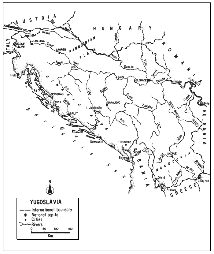
The Socialist Federal Republic of Yugoslavia, ninth largest country in Europe, occupies the northwestern portion of the Balkan Peninsula, fronting on the Adriatic Sea. Its six constituent republics (Bosnia and Herzegovina, Croatia, Macedonia, Montenegro, Serbia and Slovenia) and two autonomous provinces (Kasoro and Vojvodina) are centralized at Federal level.
Primarily mountainous, Yugoslavia has a long indented coastline, an area of great plains and slow rivers, and four large international lakes, as well as many smaller mountain lakes and streams. Transitional in position and climate between continental and Mediterranean Europe, it has drainage to three seas: the Adriatic, Aegean and Black. Much of the terrain is limestone, the country is well forested, and has abundant water resources. Traditionally an agricultural land, it is rapidly progressing into industrial development utilizing its hydroelectric and thermal (coal) resources.
The traditional capture fisheries of its lowland rivers and floodplains are declining with river regulation, drainage, and pollution, but still continue, albeit at slackened pace. Aquaculture for warmwater species continues to advance rapidly, and trout culture is also important. The opportunities for sport fishing, some of it excellent, attract both local and foreign sportsmen.
| 1. | AREA: | 255 804 km2 | |
| 2. | POPULATION: | 23 895 000 (est. 1990) | Density: 93 inh/km2 |
| 3. | PHYSICAL GEOGRAPHY | ||
Yugoslavia is situated between 40°51' and 46'53"N latitudes and 13°23' and 23'02"E longitudes.
Roughly ovate, its greatest length (ESE-WNW) is 978 km, and its greatest breadth (NNE-SSW) is about 425 km. Its altitudinal range is from sea level to 2 864 m (Mt. Triglav).
Yugoslavia is bounded by seven countries: on the extreme northwest by Italy for 202 km, on the north by Austria for 324 km and by Hungary for 623 km, on the northeast by Romania for 557 km, on the east by Bulgaria for 536 km, on the south by Greece for 262 km, and on the southeast by Albania for 465 km. Its total boundary with other countries totals 2 969 km of which 2 173 km is land, 711 km is river, and 85 km is lake. (Length of boundaries from Statistički Godišnjak Jugoslavije, 1987.)
In addition, it is bounded on the west by the Adriatic Sea for 2 092 km (or 628 km bee-line). This highly indented coast is fringed with about 1 050 islands whose inclusion raises the length of the coastline to 6 116 km. Thirty-seven of these islands are over 7 km2 in area and eight are over 100 km2.
Three-quarters of the country is mountainous and hilly. The remainder consists of plains and river valleys. About 30 percent is less than 200 m in elevation, 25 percent between 200 and 500 m, 27 percent between 500 and 1 000 m, and 18 percent above 1 000 m.
Yugoslavia has three large physiographic regions (Western, Central and Eastern) subdivided into smaller sub-regions.
(i) Western Region
(a) Adriatic or Coastal Belt. Bordering the Adriatic is a narrow strip of mainland constituting about three percent of the country. Submergence has created many gulfs, bays, coves, peninsulas and islands. Primarily limestone and flysch, some parts of the littoral are very barren, others fed by spring-backed streams are fertile, and there are some marshes. This belt is well separated from the other sub-regions by the steep Dinaric Mountains along the coast.
(b) Alpine Sub-region. This small area in the extreme northwestern part of the country, between its boundaries with Italy and Austria, contains spurs of the Karawanken and Julian Alps, including the highest part of the country. It is well forested, has a rugged terrain and contains some attractive trout lakes and streams.
(c) Dinaric Sub-region. Occupying about 40 percent of the country, this extensive mountain area extends from the Alpine area southeasterly into Albania and Greece in a series of transverse ridges parallel to the coast and ranging from 750 to 2 000 m in height. On the southwest it towers above the Adriatic or Dalmatian littoral, on the northeast it borders the Pannonian Plain. One of the most rugged mountain masses in Europe, much of it is a central plateau of thick permeable limestone with thin soil, known as the High Karst. It is highly distinctive because of its underground drainage channels formed by seepage through soluble limestone leaving the surface dry and forming many large tectonic-karstic depressions, called poljes. (There are about 1 800 poljes in the entire country.) The Neretva is the only river in this sub-region to have its entire course on the surface. Largely barren, unproductive and formidable, the Dinaric area has served to seal off the coast from the interior.
(ii) Central Region
(a) Pannonian or Danubian Plain. This southward extension of the Great Hungarian Plain lies east of the Dinaric and south of the Alpine sub-region and Hungarian and Romanian borders. Partly hilly in the west, most of these well-cultivated lowlands are flat and monotonous along the Danube and the lower reaches of its tributaries. With loess and lacustrine soils, this is the most fertile area in the country, supporting staple grains and root crops. The Sava and Drina drain its western plain; the Tisa, entering from Hungary, bisects the eastern plain. Its major rivers, more than 150 m wide and almost 2 m deep on broad floodplains are usually rimmed by low bluffs. Alders, willows, and marshes often fringe the rivers.
(b) Rhodope or Morava-Vardar Sub-region. East of the Dinaric sub-region and south of the Pannonian Plain is an area of rugged crystalline mountain blocks and enclosed basins cut from north to south by the valleys of the Morava (flowing north to the Danube) and the Vardar (flowing south to the Aegean). The depression broadens northward into the Pannonian Plain and broadens southward into the plains of Macedonia. The main part of the sub-region lying east of these river valleys is occupied by high mountains containing some glacial cirques and lakes.
(iii) Eastern Region. Lying to the northeast of the Rhodope sub-region, east of the Morava and along the Bulgarian border, are the Balkan Mountains or Stara Planina, extensions of the Carpathians. These highlands (to 2 169 m) are cut by several rivers.
In general, about 20 percent of the country is karst. The western zone of Yugoslavia is composed of limestone, dolomite, slate and marl. The Danubian plain is alluvial soil and loess. The eastern zone is primarily limestone, sandstone and granite. There are a great variety of soils. Grey podsols cover over 50 percent of the country especially in the western humid regions. Terra rossas (insoluble limestones) cover karst depressions along the littoral and in the Dinaric Mountains. Fertile chernozems are found on grasslands with low precipitation especially on the Pannonian Plain.
Lying at the southern end of the European wooded belt, most of the country is covered by a central forest region in which deciduous trees are predominant below 1 500 m with conifers above this elevation. Pasture lands lie in inter-mountain basins or above the tree line. The coastal or Mediterranean woodland areas support macchia, and brush and scrub types are also found in the highlands. A parkland region between the Drava and the Sava has now been cleared of most of its forest, and the great region of grassy steppes along the Danubian Plain is now the chief arable area of the country where cultivated plants now cover a larger area than uncultivated ones.
The geography has dictated population density to a large degree. Thus, much of the barren Karst has a very low density, only 10 inh/km2, while the density may be 200 or more in the valleys along the large watercourses.
4. CLIMATE
Yugoslavia, lying in the southern part of the north temperate zone, has three basic types of climate.
The narrow coastal area and lower Vardar Valley have a moderate Mediterranean climate with mild rainy winters and hot and dry summers. Mean temperatures of 7.5°C in January and 26.4°C in July are typical. Most of the mountain areas have a moderate continental climate with moderate summers but very cold winters, and are more humid than the interior plains. Most of the inland area such as the Pannonian has a more rigorous continental climate with warm dry summers (July averaging 23°C) and cold winters (February 1.5°C). Overall, the average temperatures in Yugoslavia are about -2° to 2°C in January and 21° to 23°C in July.
Two types of rainfall are common: (i) continental with the heaviest rain in May and June, and (ii) modified Mediterranean with the heaviest in autumn and winter and very dry summers. The average annual rainfall over all of Yugoslavia is 975 mm but its distribution throughout the country and the year is very irregular. Thus, in the Alps and Dinaric chain, the average is over 1 500–2 000 mm. On the Pannonian Plain it is 500–700 mm, and in the Vardar Valley it is only 400 mm. Although most areas experience drought in most years, an area near Titograd has a rainfall of 5 000 mm per year, one of the highest averages in Europe.
In the more elevated areas, long snowy winters prevail. Snow may fall 30–50 days a year. On the northern plains, snow is light but frequent and sections of the large streams are frozen.
In the western and highland areas the growing season is 6 months or less. In the Pannonian area it averages 7 months. On the southern littoral it lasts almost all year.
5. HYDROGRAPHY AND LIMNOLOGY
Table 6 indicates that the total area of inland water in Yugoslavia is only 400 km2 or 0.16 percent of the country's total area, a figure unaltered for at least 15 years. This ridiculously low figure is obviously incorrect. Reference to Table 5 shows that the Yugoslavian lake area shown there is almost three times the Table 6 figure for its inland waters. (See the chapter for Italy; the situation may be similar.) Meschkat (1956) stated that the total surface of inland waters in Yugoslavia “exploited for economic fishing” covered about 2 500 km2. Fijan (1976) stated that the country had 2 460 km2 of inland waters, and Yugoslavia/EIFAC (1979) stated that the area exploited for economic fishing was almost 2 570 km2, composed as follows: Danube system (1 300 km2), other rivers (200 km2), and lakes and reservoirs (1 070 km2). Fabijanić (1980) says that the inland waters of Yugoslavia are 1.4 percent (i.e., about 3 581 km2) of the country's total area. Bojčić (1986) says that the total area of streams and lakes in Yugoslavia is about 2 900 km2. It seems apparent that at least one percent of the country's total area is composed of inland waters.
According to Van der Leeden (1975) and ECE (1978), the average annual runoff from rainfall on Yugoslavian territory is 430 mm or 110 000 million m3, to which can be added about 117 000 million m3 received from upstream countries. This results in a total annual river discharge leaving the country of 227 000 million m3. Higher figures are given by Kuzmanovski (1977) and Miloradov and Djordjevic (1978) of 129 000 million m3 from rainfall in Yugoslavia and 115 000 million m3 from upstream countries: a total of 244 000 million m3 annually.
The origin and runoff of the waters rising in Yugoslavia are shown in Table 1. Of the 115 000 million m3 from upstream countries (47 percent of Yugoslavia's water balance), 84 percent is brought in by the Danube (72 000 million m3) and Tisa (about 25 000 million m3), and the remaining 16 percent by the Drava, Mura and some smaller rivers (Kuzmanovski, 1977).
Table 1
Origin and runoff of waters originating in Yugoslavia
| Drainage basin | Annual average | ||
| Basin area km2 | Discharge m3/sec | Runoff Million m3/year | |
| Sava | 96 400 | 1 685 | 53 138.2 |
| Morava | 37 470 | 255 | 8 041.7 |
| Beli Drim | 4 360 | 60 | 1 892.2 |
| Vardar | 22 258 | 174 | 5 487.2 |
| Strumica | 1 370 | 6 | 189.2 |
| Adriatic rivers | 46 354 | 1 642 | 51 782.1 |
| Other watercourses | 44 546 | 209 | 6 591.0 |
| Total | 255 804 | 4 088 | 128 919.1 |
Source: Kuzmanovski (1977) (additions as given in source)
Of the total area of Yugoslavia, 70 percent drains into the Black Sea via the Danube, 21 percent into the Adriatic Sea, and 9 percent into the Aegean Sea, almost entirely through the Vardar River. The actual quantity of water dispersed through each drainage area is shown in Table 2.
Table 2
Quantity of water flowing through Yugoslavia
| Drainage basin | Average annual runoff in 1 000 million m3 | ||
| From within Yugoslavia | From outside Yugoslavia | Total outgoing river discharge | |
| Black Sea | 67.77 | 115 | 182.77 |
| Adriatic Sea | 55.47 | - | 55.47 |
| Aegean Sea | 5.68 | - | 5.68 |
| Total | 128.92 | 115 | 243.92 |
Source: Kuzmanovski (1977) and Vujanac-Borovnica and Krstič (1981)
5.1 Rivers (Reke)
Yugoslavia may have more rivers for its size than any other European country according to the Encyclopedia Britannica (1974) which gives their total length as 118 371 km. Another estimate of similar magnitude states that there are about 1 900 streams over 10 km long totalling over 115 000 km in length (see Dill, 1966). Vojnović (1975) states that the average density of rivers in Yugoslavia is 462 m/km2, indicating that the total length of its rivers is about 118 181 km. Similar figures of total length are given by Fabijanić (1980), 118 370 km, and Vujanac-Borovnica and Krstić (1981), 118 371 km. On the other hand, Mellen (1957) and Framji and Mahajan (1969) say that Yugoslavia has about 1 850 streams over 10 km long, and the latter authors, as well as Yugoslavia/EIFAC (1979) indicate their total length as 43 326 km. Kuzmanovski (1977) states that the average density of rivers in the country is only 100 m/km2 (i.e., a total length of 25 580 km), while at the same time says that their total length is over 43 000 km. Such discrepancies cannot be explained by the author, but he is inclined to accept the higher figures.
Table 3 shows the principal rivers in Yugoslavia: their length, basin size, and mean annual discharge. Table 4 shows the seasonal flows in four major Yugoslavian rivers.
Despite the large annual discharge, the spatial and temporal distribution of precipitation and consequent discharge is unfavourable to water consumers in the heavily populated agricultural or industrial areas. Specific runoff varies from 0 to 8 1/sec/km2. The ratio of average stream flow in wet and dry years is often greater than 3 to 1. Thus, for example, in a medium dry year, the discharge of domestic waters falls from its average of 129 000 million m3 to only 60 000 or 70 000 million m3. Seasonal discharge fluctuations are also considerable. Runoff in most catchment areas has a markedly torrential nature. In the dry periods of summer and autumn, most rivers have little water; the ratio of minimum to maximum annual stream flow on small rivers is 1:1 000, and there are said to be 13 000 torrential streams in the country.
Drainage on the western slopes of the Karst is provided by underground drainage and by short surface streams, often rapid and turbid and often dry in summer. Here, only the Neretva is a real stream. On the eastern rough mountainous slopes the rivers often flow through steep gorges. Most have swift currents, rocky beds and sharp twists. On the northern plains, where all the drainage is to the Danube, the major tributaries are large broad rivers usually over 150 m in width. High water is usually from March/April to May/June, low water from mid-July to late October. This plains area also has many levees and connecting canals. In the southeast, the rivers which generally flow through broad valleys are shorter than the northern plains rivers, but their regime is similar: usually high and swift from March until June and low from July to October.
Table 3
Principal rivers in Yugoslaviaa
| River | Length (km) | Drainage basin (km2) | Mean annual discharge at mouth (m3/sec) | |||
| Within Yugoslavia | Total | Within Yugoslavia | Total | |||
| Danube/Dunav | 588 | b | 2 857 | 210 180 | 817 000 | 5 750 |
| Tisa | 168 | c | 966 | 17 300 | 157 200 | 945 |
| Sava | 945 | 945 | 95 719 | 96 328 | 1 690 | |
| Drava | 437 | d | 707 | 12 033 | 40 150 | 620 |
| Mura | 143 | e | 438 | - | 13 800 | - |
| Vardar | 300.5 | 420 | 22 387 | 28 410 | 146 | |
| Drina | 346 | 346 | 19 445 | 19 712 | 371 | |
| Tamiš | 111 | 340 | 4 816 | 13 386 | - | |
| Južna Morava | 304 | 304 | 14 232 | 15 469 | - | |
| Kupa | 292 | 292 | 10 032 | 10 032 | 283 | |
| Bosna | 273 | 273 | 10 457 | 10 457 | 174 | |
| Ibar | 272 | 272 | 8 059 | 8 059 | - | |
| Zapadna Morava | 268 | 268 | 14 721 | 14 721 | - | |
| Begej (Plovni) | 75.5 | 244 | 2 095 | 6 565 | - | |
| Neretva | 225 | 225 | 11 798 | 11 798 | 378 | |
| Nišava | 151 | 218 | 2 737 | 3 974 | - | |
| Una | 212 | 212 | 9 368 | 9 368 | 202 | |
| Crna | 207 | 207 | 5 582 | 5 582 | - | |
| Timok | 202.7 | 202.7 | 4 682 | 4 682 | 39 | |
| Lim | 197 | 197 | 5 936 | 5 936 | - | |
| Vrbas | 192 | 192 | 5 023 | 5 023 | 102 | |
| Morava | 185 | 185 | 37 444 | 37 444 | 232 | |
a Those over 180 km, arranged in order of total length
b Danube: 359 km in Yugoslavia plus 229 km along boundary
c Tisa: 164 km in Yugoslavia plus 4 km along boundary
d Drava: 342 km in Yugoslavia plus 95 km along boundary
e Mura: 70 km in Yugoslavia plus 73 km along boundaries
Source: Statistički Godišnjak Jugoslavije 1987 for lengths and area. Discharge from Van der Leeden (1975) after Pecinar, Water Power of Yugoslavia, Serbian Academy of Science, 1968.
There is usually floating ice on the Danube, Tisa, Sava, and Drava from December until February, although no ice may form in some years.
Otherwise, with respect to water temperatures, the following records for 1985 indicate the annual range for seven representative Yugoslavian rivers (Statistićki Godišnjak Jugoslavije 1987):
| Temperature °C | |||
| Maximum | Mean | Minimum | |
| Danube at Zemun | 24.5 | 10.8 | 0.0 |
| Tisa at Senta | 25.2 | - | 0.0 |
| Sava at Slavonski Brod | 26.2 | 12.7 | 0.1 |
| Drina at Bajina Bâsta | 17.1 | 9.6 | 1.0 |
| Vrbas At Delibašino selo | 20.0 | 11.0 | 2.0 |
| Velika Morava at Cúprija | 26.2 | 11.9 | 0.0 |
| Vardar at Skoplje | 25.0 | 11.1 | 0.0 |
Some of the major rivers of Yugoslavia are described below.
Table 4
Seasonal discharge of four major rivers in Yugoslavia
| Drava, Donji Miholjac | Sava, Sremska Mitrovica | V. Morava Ljubicevski most | Danube, Veliko Gradisto | |
| Basin area km2 | 8 880 | 7 222 | 7 342 | 6 217 |
| Mean monthly discharge, m3/s | ||||
| January | 391 | 1 830 | 262 | 5 460 |
| February | 396 | 1 980 | 396 | 6 000 |
| March | 482 | 2 320 | 450 | 7 120 |
| April | 558 | 2 440 | 438 | 8 100 |
| May | 775 | 2 080 | 362 | 7 780 |
| June | 846 | 1 460 | 246 | 6 730 |
| July | 691 | 977 | 133 | 5 720 |
| August | 589 | 630 | 82.7 | 4 670 |
| September | 502 | 589 | 78.4 | 4 080 |
| October | 487 | 900 | 93.0 | 4 000 |
| November | 578 | 1 760 | 147 | 2 250 |
| December | 472 | 2 070 | 201 | 5 500 |
| Year | 561 | 1 590 | 240 | 5 870 |
| Period of record | 1921–66 | 1941–66 | 1941–66 | 1921–66 |
Source: Van der Leeden (1975) after Unesco (1971)
Danube drainage
Danube. The Dunav as it is called in Yugoslavia, has a total length of 588 km in Yugoslavia and as its border stream1. Entering from Hungary, it proceeds southeasterly for 359 km. It then becomes the Yugoslav/Romanian boundary for another 229 km, and leaves the country at the boundary between Yugoslavia, Bulgaria, and Romania about 80 km below the Iron Gate.
1 Known as the Duna in Hungary, Dunav in Bulgaria, and Dunarea in Romania
Throughout the Yugoslavian section, the Danube has a river bed width of 1 to 2 km, a depth of 2.5–7 m and an average flow of about 2 800–5 400 m3/sec. At low water it may have a width of only 180 m in some places; at other times it may widen to 3 km or deepen in places to 45 m. High water is generally in spring and early summer and low water in autumn.
Like the Hungarian section above it, the Yugoslavian Danube belongs to the cyprinid zone and is a true plains river, formerly with extensive overflow areas supporting good fisheries. When it reaches the Romanian border it cuts a swift course through the defiles of the West Transylvanian Alps, and below Orsova passes through the Iron Gate, long a deterrent to shipping until by-passed by canal and now dammed and equipped with navigation locks (see section 5.3).
The Danube's major tributaries in Yugoslavia are the Drava, Sava, Morava, and Timok from the right, and from the left the Tisa and Tamiš. These are interlaced with canals and the Danube is fully navigable (see sections 5.5 and 6).
Although the Danube receives a pollution load from upstream countries and receives big loads at Novi Sad and Belgrade and from its tributaries, it is still only moderately polluted due to high oxygen saturation and dilution from its affluents. The pollution has, nonetheless, diminished its fisheries as have river training, canalization, and drainage.
Drava. This swift, strong river flows east from Austria (known there as the Drau) into Yugoslavia and thence for 437 km east southeast to the Danube. For 95 km of this course, it forms a boundary with Hungary. Its tributaries bring in much water during the spring snowmelt, and it has a higher water level in summer than most other Yugoslavian rivers. Throughout the section it varies from 120 to 245 m in width, and there is an extensive floodplain area between the Drava and its junction with the Danube.
Mura. Originating in Austria as the Mur, the major Yugoslavian tributary of the Drava forms part of the Austrian/Yugoslav boundary for 32 km and part of the Yugoslav/Hungarian boundary for 41 km of its 143-km course through the country.
Sava. Formed in the northwest Alpine area, the Sava, the largest river entirely within Yugoslavia, flows southeasterly for 945 km to join the Danube near Belgrade. It has a gentle gradient, dropping only 45 m in its lower course below Zagreb. The Sava has two periods of high water, one in the spring and one in the autumn. It has a low in winter and another in late summer. It is an important river, picking up much of the drainage from the northeastern slopes of the Dinaric range, being navigable with a draft of 2.5 m for 543 km, and providing a river fishery. Its major right hand tributaries proceeding downstream are the: Kupa, Una, Vrbas, Bosna and Drina. Circa 1981, it was considered one of the most polluted rivers in Yugoslavia, having deteriorated throughout its course.
Velika Morava. Next below the Sava, entering the Danube from the right, is the Velika or Great Morava River. Formed by the junction of the 318-km Južna (southern) Morava and 268-km Zapadna (western) Morava, it continues for 185 km to a deltaic mouth, draining much of southeastern Yugoslavia1.
Tisa. The longest tributary of the Danube entering Yugoslavia is the sluggish Tisa which enters from Hungary (known there as the Tisza) and courses south through the eastern Pannonian Plain for 164 km to its mouth. This well-embanked river is subject to great floods caused by melting snows in spring and rains in summer and autumn. It has a new dam with locks about 63 km above its mouth.
Tamiš. The only other important left hand tributary of the Danube to enter Yugoslavia is the Tamis which originates in Romania as the Timis. After entering Yugoslavia, it flows generally south for 111 km to enter the Danube below Belgrade.
Adriatic Drainage
Neretva. The Neretva, the only Yugoslavian Adriatic river of importance, has cut a deep canyon to below the level of the water table in the Dinaric chain. Rising north of Gacka, it flows northwest and then southwest for 225 km to the Adriatic, receiving the Rama and Bregara en route.
Two other Adriatic rivers, both international, should be mentioned. One is the Bojana, an international boundary between Yugoslavia and Albania (there known as the Buenë), and the outlet of Skadar Lake (see section 5.2). The other river, which drains a small portion of Yugoslavia, is the Drin or Drim, an Albanian river formed by the junction (in Albania) from the south by the Crna (Black) Drin from Lake Ohrid, and from the north by the Beli Drim (White Drin) which also originates in Yugoslavia (see Albania).
Most of the other Yugoslavian drainage into the Adriatic comes from short, impermanent streams or underground drainage which sometimes enters the sea below sea level.
Aegean Drainage
Vardar. The major river of southernmost Yugoslavia and northeastern Greece is the Vardar River. Rising in the mountains it flows north-northeast and southeast to enter Greece (where it is called the Axios) and proceed to the Aegean Sea. With a total length of 420 km, 300 of these are in Yugoslavia. Its principal Yugoslav tributary is the 207-km Crna Reke.
Strumica. The Strumica which drains southeast into Bulgaria to the Struma, which proceeds through Greece (as the Strymon), is the only other major Yugoslavian stream in the Aegean drainage.
5.2 Lakes (Jereza)
There are about 220 lakes and reservoirs in Yugoslavia with a total area of about 1 600 km2 (Kuzmanovski, 1977; Vujanac-Borovnica and Krstić, 1981) of which 11 are over 1 000 ha in area. The lake area exploited for commercial fishing totals about 107 000 ha (Yugoslavia/EIFAC, 1979). Table 5 lists 28 of the largest lakes totalling over 1 129 km2 in Yugoslavia alone. Four of these are shared with other nations.
Table 5
Principal lakes of Yugoslaviaa
| Name | Total area km2 | Altitude m | Maximum depth m |
| Skadarsko/Skadarb | 391 | 6 | 44 |
| Ohridsko/Ohridc | 348.8 | 695 | 286 |
| Prespansko/Prespad | 274 | 853 | 54.2 |
| Derdapsko/Djerdape | 253 | 69.5 | 92 |
| Buško | 55.8 | 716.5 | 17.3 |
| Dojransko/Dojranf | 43 | 148 | 10 |
| Bilećko | 33 | 400 | 104 |
| Vransko (kod Biograda) | 31.7 | 0.1 | 3.9 |
| Modračk (kod Tuzle) | 17.1 | 200 | 17 |
| Tikveško | 14 | - | 95 |
| Jablaničko | 13.3 | 270 | 70 |
| Debarsko | 13.2 | 580 | 92 |
| Perućko (na Cetini) | 13 | 360 | 64 |
| Perućačko (na Drini) | 12.4 | 290 | 70 |
| Mavrovsko | 12 | 1 197 | 48 |
| Vlasinko | 12 | 1 208 | 22 |
| Gasivode | 11.9 | 692.7 | 105 |
| Prokljansko | 11.1 | 0.5 | 25 |
| Ribnjak (Našice) | 11 | 103 | 2.5 |
| Zvorničko (na Drini) | 8.1 | 140 | 28 |
| Zlatarsko (na Uvcu) | 7.25 | 885 | 75 |
| Vrana (na Cresu) | 5.8 | 16 | 74.4 |
| Belo | 4.8 | 75 | 2.5 |
| Palić | 4.2 | 101 | 3.5 |
| Bohinjsko/Bohinj | 3.28 | 523 | 44.5 |
| Plavsko | 1.99 | 906 | 9.1 |
| Plitvicka (I.G. jereza) | 1.98 | 503–636 | 46 |
| Bledsko/Bled | 1.45 | 475 | 30.6 |
| Plivsko (Veliko) | 1.148 | 424 | 36.2 |
| Durmitorska (io jezera) | 0.98 | 1140–1788 | 49.1 |
a Includes some reservoirs, e.g., Derdapsko
b Shared with Albania. Yugoslav portion is 243.1 km2 (62 percent)
c Shared with Albania. Yugoslav portion is 229.9 km2 (66 percent)
d Shared with Albania and Greece. Yugoslav portion is 177 km2 (65 percent)
e Reservoir shared with Romania. Yugoslav portion is 178 km2 (70 percent)
f Shared with Greece. Yugoslav portion is 27.4 km2 (64 percent)
Source: Statistički Godišnjak Jugoslavije, 1987
Glacial lakes are fairly numerous but small in size. Most of these are located in cirques in high mountains, but the most famous (e.g., Bled and Bohin) are in mountain valleys. Some of the lakes are fluviatile, created as oxbow or overflow lakes on the Pannonian floodplain. The largest and most interesting Yugoslavian lakes are, however, developed in poljes or tectonic karstic depressions, e.g., the series of graben lakes which stretch eastward from Lake Skadar into Macedonia. Generally monomictic or “subtropical”, they are known as the Balkan or Aegean lakes. There are also some simpler karstic or solution lakes, periodically flooded polje lakes (e.g., Bǔsko), and coastal or lagoon-type lakes.
Some of the most prominent lakes are described below.
Skadar/Scutari/Shköder. The largest lake in the country, Skadarsko, as it is known here, lies at the southern end of the Yugoslavian littoral on the Albanian border. It is fed by a number of mountain streams, including the 97-km salmonoid river Moracǎ. It is tributary to the Adriatic through the Bojana (Buenë) River which has a link with Lake Ohrid through a connection with River Drim. The outlet has silted up so that the lake is almost cut off from the sea, but has some marine migrants including sturgeon (Acipenser spp.), European eel (Anguilla anguilla), grey mullets (Mugil spp.), shad (Alosa fallax), and sea bass (Dicentrarchus labrax).
Due to annual flooding, the lake's area has varied from 360 km2 in summer to 690 km2 in winter/spring. At an area of 391 km2, 62 percent (243.1 km2) lies in Yugoslavia, the remainder in Albania. At an area of 372 km2, it has an average depth of 4.4 m; at higher elevations it may still only be 7–8 m in average depth. Despite its shallowness, it has a number of crypto-depressions up to 63 m in depth, which, at least in Yugoslavia, yield almost half of the lake's commercial harvest, even though they occupy only about one percent of its area.
Surface water temperatures of this warm, polymictic lake exceed 30°C in summer and decrease to about 7°C in winter. It is well oxygenated, has a pH of 7.5 to 8.4, and a morphoedaphic index of 45.
It contains 15 families of fish of 37 species but cyprinids make up 96 percent of the fish biomass. The largest freshwater fishing grounds of the Balkan Peninsula, Skadar has an annual yield of 800 to 1 200 t of fish. Of this harvest, common carp (Cyprinus carpio) and bleak (Alburnus albidus) are the most valuable food fish but considerable quantities of “scrap” fish such as Pachychilon pictus and Rutilus rubilo are also taken.
Skadar Lake has lately been subjected to intensive industrial and agricultural development including pollution of its tributaries.
Lake Ohrid/Oridsko. Ohrid, the most famous and second largest lake in Yugoslavia, is a permanently inundated karstic polje, a tectonic depression or graben lake on the Yugoslav/Albanian border. Fed almost entirely by underground water from karstic sources, some of them from effluents of Lake Prespa, it has a superficial outlet to the River Drim/Drin. It has a total area of 348.8 km2 of which Yugoslavia owns 229.9 km2 or 66 percent. It has a length of 30.8 km, width of 14.8 km, mean depth of 145.2 m, maximum depth of 286 m, and volume of 50.53 km3.
Thermically, it is a warm monomictic or “subtropical” lake; its water mass always remains above 4°C. It can also be considered a productive oligotrophic lake, with an annual productive rate of 108.3 mg/C/m2/year (Ocerski and Allen, 1978).
Biologically, Ohrid is of extreme interest in having an archaic fauna including more endemic organisms than any other lake in Europe (see the extensive studies summarized by Stankovič, 1960). Of its 17 species of fish, 10 are endemic, including the cyprinid Pachychilon pictus, and the salmonids Salmo letnica and Salmothynnus ohridanus. During the 1930–57 period, the catch in the Yugoslavian part of the lake averaged 226 t annually (Stankovič, 1960). Salmo letnica accounted for 43 percent of the catch and bleak (Alburnus albidus) for 27 percent of its catch during the 1929–73 period (Točko, 1975). An eel population is being sustained through stocking with elvers from France.
Prespa Lake/Prespansko. Also known as Lake Prespë or Megali (Big) Prespa, this 274-km2 international lake is shared as follows: Yugoslavia (176.8 km2 or 65 percent), Albania (49.4 km2 or 18 percent), and Greece (47.8 km2 or 17 percent). (The source of Table 5 (1987) states that the area of this lake is 274 km2. However, a study by Ocevski and Allen (1984) says that its area is 313.6 km2.) It is an oligo-eutrophic lake with karstic features whose waters disappear into sinkholes. It has a maximum depth of 54.2 m, an average depth of 20 m, and a volume of about 4 km2. Its catch is primarily of cyprinids.
Dojran/Dojransko. The last in this series of international Balkan lakes is Dojran, shared with Greece where it is known as Doiranis. Yugoslavia's share of this 43-km2 graben lake is 27.4 km2 or 64 percent. In the Aegean lake zone, this eutrophic lake has a mean depth of 6.5 m and a maximum depth of 10 m. Like Prespa, it is a cyprinid lake and is quite productive.
Dojran is rather unique in being the site of a fishery where diving birds (especially mergansers, grebes, cormorants, and loons) are used to drive fish into traps where they are captured by fishermen (Apostolski and Matvejev, 1955; Meschkat, 1957).
Other lakes. Typical large salmonid lakes in the Alpine zone of Yugoslavia are the glacial lakes of Bled (1.45 km2) and Bohinj (3.28 km2) in Slovenia. The most striking of the karstic lakes are the 16 beautiful lakes, totalling 1.98 km2 in the Plitvice group. Situated at about 500 m in Croatia, they are fed by springs or underground streams and drain by potholes. Other mountain lakes include seven Triglav lakes in Slovenia, and 30 lakes in the Dinaric ranges of Montenegro. Coastal lakes are represented by Lake Vrana (see section 5.4).
5.3 Reservoirs
In consideration of its size and number of waters, Yugoslavia's watercourses are still not intensively regulated, and most of its static water consists of natural lakes. Most of its storage reservoirs have been constructed for power generation and there are still comparatively few multipurpose reservoirs. Nevertheless, by 1978 there were 102 large dams (over 15 m in height) in the country: 94 constructed after the second world war and 21 during the 1970–77 period. At this point, Yugoslavia ranked tenth in Europe and twentieth in the world in number of large dams.
Of the resulting reservoirs, the largest is the Djerdap (Derdapsko) at Iron Gate on the Danube, the greatest hydroelectric project in Yugoslavia and Romania. Formed in 1971 by a concrete dam, 59 m high and with a crest of 1 228 m, the water level has been raised 34 m and there is a two-flight lock on each bank. The ship chamber lock is 310 m long, 34 m wide, and 4.5 m deep. Two hydropower plants use 270 km of the Danube with a power capacity of 2 050 MW. The spillway provides for release of 16 500 m3 of water. With a total area of 253 km2, 70 percent (178 km2) of the reservoir is in Yugoslavia and 30 percent (75 km2) is in Romania. At high water, differences between the flowing river water and the reservoir are very slight, and there is only a brief retention time without real stratification. Daily water fluctuations of about 8 m are not conducive to a good fishery.
A number of new dams are under construction, and more will follow. The tendency now is to construct multi-purpose dams, not just for hydroelectric power but to provide domestic, industrial and irrigation water and recreation. Some have been constructed to hold spoil, mine tailings, and other wastes.
5.4 Lagoons
Levi and Troadec (1974) reported, without being specific as to location, that there were three major basins or brackish water complexes in Yugoslavia, totalling 14 200 ha in extent, ranging from 1 to 18 m in depth, and with salinities ranging from 0.5 to 8 ppt. Amanieu and Lasserre (1981) also said that there were 14 200 ha of lagoons in Yugoslavia which produced 360 t in 1971.
In an earlier paper, Krstinić (1956) stated that there were only two areas on the Yugoslavian coast characterized by lagoons. The first of these is Lake Vrana (Vransko Jezero) with an area of 31.7 km2, average depth of 2 to 2.5 m and maximum depth of 4 m, and salinity of 2 to 8 ppt. It has a subterranean connection with the sea as well as by an artificial canal, and is fed by two principal freshwater affluents. Water temperature in the lagoon varies between 0° and 30°C and in harsh winters the lake may be ice-covered. The species fished are grey mullets, European eel, Atherina, and a blenny (Blennius fluviatilis). Common carp have also been reported from here. Krstinić (1956) stated that the fishing, performed with fixed gear, and production, without artificial feeding, was 20 to 25 kg/ha/year.
The second area described by Krstinić (1956) was a lagoon area at the mouth of the Neretva River, the most important Yugoslavian river debouching directly into the Adriatic. Here several lagoons are found with a total area of 1 200 ha, depths ranging from 0.3 to 1 m, salinities ranging from brackish in the summer to completely fresh in the winter, and temperatures rising above 30°C. The water does not freeze but there is a lack of oxygen in the summer which may cause mortalities. Communication with the sea is direct and fresh water enters from the river and subterranean channels. The species entering the lagoons are grey mullet, eel, sea bass, gilthead (Sparus auratus), and sole (Solea vulgaris).
In addition to Lake Vrana and the Neretva complex, Krstinic (1956) stated that there were several thousand hectares of semi-enclosed canals or bays along the Yugoslavian coast which support populations of mullets, sea bass, gilthead, etc. These areas include: the sea of Novigrad, the lake of Prokljan, and bay of Jadrtovac. Capture of fish in these areas is possible in the narrow channels connecting them with the open sea when the fish leave in the late year.
Despite the existence of these lagoons or lagoon-like areas, brackish water fishing or aquaculture has never been developed in Yugoslavia to the extent that it has in Italy across the Adriatic. However, there has been a considerable activity here in recent years (see section 7.2).
5.5 Canals (Kanala)
Yugoslavia has a canal system used for navigation, irrigation, and to alleviate water congestion. The basic one, the Danube-Tisa-Danube Hydro-system, totalled 644 km of navigable waters alone circa 1977. Among the many connections are the Veliki Canal connecting the Tisa with the Danube, the Mali connecting the Veliki with the Danube, the Tisa with the Begej River, and the Begej with the Danube. (Both Yugoslavia and Romania are affected by Begej regulation.)
Many large schemes for new waterways have been considered. These include: linking the Danube with the Aegean Sea via the Morava and Vardar, connecting the Danube and the Sava, and canals linking the Sava with the Adriatic.
In addition to navigational canals, Yugoslavia has over 3 000 km of main irrigation canals and a network of drainage ditches (see section 6).
Yugoslavian canals are usually less than 60 m wide and average about 1.5 m in depth. They are important for fisheries although constantly being dredged to remove silt.
6. LAND AND WATER USE
Table 6
Pattern of land use in Yugoslavia, 1986
| Percent | |
| Arable and permanent crops | 30.4 |
| Permanent pasture | 25.0 |
| Forests and woodlands | 36.5 |
| Other land | 8.0 |
| Inland water | 0.16 |
| Total | 100.0 |
Source: 1987 FAO Prod.Yearbook, 41 (Publ. 1988)
Yugoslavia has a rural population (of about 50 percent) and despite its generally maintainous terrain, over 50 percent of Yugoslavia is used for agriculture. Three-quarters of its arable land is used for cereals; maize, wheat, sugar beets, tobacco, potatoes, fruit, and the vine are principal crops. Waterdemanding sub-tropical crops, such as cotton, are grown in the extreme southern section. Livestock raising is of smaller proportions. Sheep and goat grazing affects vegetational cover and runoff in some areas. Although climatic conditions demand intensive irrigation in Yugoslavia, only about 2 percent of the cultivable land was irrigated in 1986. Land drainage and diking along the main lowland rivers, especially the Danube and Sava, have reduced the floodplain fisheries. There has also been reduction of marshes and swamps, and there are periodic attempts to lower water levels in lakes such as Skadar to provide additional agricultural land. Although fertilizer production is now a very large segment of the Yugoslav chemical industry, application to crops has lagged far behind that of most European countries, being one of the lowest on the continent. (Effects of agriculture on water and fisheries are summarized at the end of this section and in section 9.)
With about one-third of the country under forest, a higher proportion than any other European country except Austria and in Scandanavia, there is considerable lumbering, and in 1985 Yugoslavia ranked eighth in roundwood production in Europe. Deciduous trees such as oaks and beech are dominant; conifers are secondary. Preserved forests, the bulk in the highlands, account for about 65 percent of the wooded area, 20 percent is degraded, 14 percent is coppice, and I percent is macchia. A number of rivers are used to float logs. There is a programme of afforestation.
Mineral resources are varied, abundant, and well distributed. Important deposits include: copper, lead, zinc, low grade coal (especially lignite), petroleum, gas, and oil shales, iron, bauxite, chromite, antimony, mercury, magnesite and some uranium. The effluent resulting from mining and processing has often resulted in pollution of fisheries, e.g., the total fish fauna in 80 km of the River Pek was destroyed by copper mine pollution.
Yugoslavia has a large potential for hydroelectric power, ranking among the highest countries of Europe, because of its relief, level of rainfall, river slopes, and river density. It is estimated at about 66 000 million kWh/year. In the past, most of the reservoirs in Yugoslavia were constructed to furnish hydroelectric power, and there is still much of the water resource to be utilized. Circa 1981, only about 37 percent of the potential was exploited by 71 hydroelectric power dams (Vujanac-Borovnica and Kristič, 1981), and it was still only about 40 percent exploited by 1985 (Durié, 1985). In 1987, of a total installed power capacity of 16 150 000 kW, hydroelectric power represented 43 percent (7 000 000 kW). The remainder of the power was thermal (7 900 000 kW) using Yugoslavia's abundant supply of lowgrade coal for most of it, nuclear (650 000 kW) and geothermal (600 000 kW).
Industry, now over half of the labour force, is largely concerned with the production of steel and other metals, chemicals, wood products including pulp and paper, cement and textiles. These, as well as distilleries, flax and hemp retting, packing and slaughterhouses have produced large amounts of effluent. Although the northwest was traditionally the industrial zone, the Governmental policy of economic equality for all republics has engendered the dispersal of economic enterprises and therefore, extended the zones of heavy pollution.
Land transport (1986) with about 10 000 km of railways, and 127 000 km of roads with a road density of 0.5 km/km2 is only reasonably good in Yugoslavia. Rugged terrain and poor surfaces hold down transport and many areas of the country remain inaccessible. Furthermore, passenger car ownership is low, only 103 vehicles per 1 000 circa 1982, and their manufacture in Yugoslavia did not begin until 1954.
Most of the domestic water supply comes from ground water, (Vujanac-Borovnica and Kristić, 1981, say there are 5 000–7 000 million m3), but use of river water is increasing. Sewerage has been slow to develop and there are still few single large discharges. Similarly sewage treatment has lagged.
There are about 2 410 km of navigable waterways in Yugoslavia. Rivers constitute 1 745 km of this total: Danube (588), Drava (75), Tisa (164), Sava (653), Kupa (75), Tamiš (53), and the lower reaches of the Adriatic streams, Neretva (20), Krka (15), Zrmanja (11), and Rijeka Crnojevica (12) (S.F.R.J., 1987). In addition, there are 664 km of canal in the Danube-Tisa-Danube system, and two navigable lakes, Ohrid and Prespa. In the largest segment, the Danube, barges to 5 000 t can ascend to Belgrade and those of 1 500 t can traverse the remainder (Kuzmanovski, 1977). Traffic is increasing on all these waterways with consequent problems to the fisheries accrued by channelization, dredging and pollution.
All of these water uses (for irrigation, drainage, flood control, production of hydroelectric and thermal power, industrial and domestic supply, and direct use for effluent disposal) have inflicted drastic changes in the hydrographic network and in its quantity and quality of water, with consequent changes in the fisheries. The many river training projects include (through 1977) over 1 030 km of meander cuttings (895 in the Danube basin alone), plus 1 000 km of bank reinforcement, and 300 km of other river training structures (Yugoslav Survey, 1977a). The flood-protected areas in Yugoslavia total over 2 million hectares and there are 5 650 km of levees. There are, in addition, about 3 000 km of main irrigation canals and over 7 000 km of distribution ditches.
Water quality is greatly affected by erosion in this country with many torrential streams. Palošević (1988) says that 90 percent of the farm land is eroded. The overall annual sediment yield is estimated at more than 176 million m3 or an average of 690 m3/km2/year.
Water pollution from domestic and industrial sources is also a growing concern in Yugoslavia. Of the total streamflow in 1976, only 22 percent was considered as first class quality waters (i.e., it could be used for drinking and for fish farming), 39 percent was second class (also suitable for fish farming, for bathing and with treatment for drinking), 32 percent was third class (suitable for irrigation and industrial use), and 7 percent was fourth class (requiring special treatment before use), Vujanac-Barovnica and Kristić (1981). In 1975, the rate of effluent discharge was about 192 m3/sec of which about 11 percent (21 m3/sec) originated from communities, and the remainder from industries and steam power stations. Thermal plants are considered the highest polluters of both water and air in Yugoslavia. Of the total waste water, aside from steam power plants, the bulk comes from ferrous metallurgy and the chemical, pulp and paper, and food industries. Pollution is also growing with increased use of pesticides and fertilizers in agriculture although their use is still minor compared with that in most European countries.
The amount of water required for different uses in Yugoslavia has been outlined by Kuzmanovski (1977) as follows.
With respect to overall water use, domestic and industrial consumption is about 2 500 million m3 annually. Of this amount, public water supply uses about 25 percent, steam power plants 30 percent, and other industries use about 45 percent. Most of the domestic supply comes from ground water; most of the industrial supply from surface water, 80 percent from the Black Sea drainage, 10 percent from the Adriatic and 10 percent from the Aegean. Irrigation uses about 644 million m3 annually, of which about 598.6 million (93 percent) comes from surface water, 281.5 million m3 directly from streams and 317.1 million m3 from reservoirs. (Almost 90 percent of this surface water is used in the single republic of Macedonia, and over 6 percent in Serbia.)
Surprisingly enough, the annual water requirement for fish farms (primarily for 13 000 ha of carp ponds) is about 430 million m3, mostly, of course, flowing, non-consumptive use (see section 9.2).
Although Yugoslavia has a long indented coastline, its marine fisheries have been of minor importance. Confined to the Adriatic, the Sea's comparative unproductivity, unsuitable bottom for trawling, and unfavourable weather conditions, have been factors in this. During the 1975–80 period, the Yugoslav marine fisheries averaged only 34 784 t annually, while the inland fishery averaged 24 260 t or 41 percent of the country's total. Furthermore, at least at one time, the inland catch was more important in terms of value than the marine catch (see Pažur, 1966). The inland “catch”, which includes the production from fish culture, and commercial fishing in the large lakes, rivers and overflow areas, will be discussed in section 7. The per caput consumption of fish increased from 1.5 kg in 1960 to 4.3 kg in 1981, but has decreased to 3.4 kg circa 1986.
Tourism itself (8.9 million tourists in 1987) is now an important source of foreign currency with the leading role played by the coastal area and its hinterland. Mountain areas attract hikers and hunters, but angling has not been stressed as a tourist attraction despite its potential. In fact, Marković (1988) considered fishing in Yugoslavia an “overlooked form of tourism”.
7. FISH AND FISHERIES
Dudich (1967) lists 49 species of fish belonging to 15 families as resident in the Yugoslavian Danube. (Djerjap Dam has, however, barred five species of anadromous sturgeons and two clupeids from ascending from the Black Sea.) Of these, about eight families are of commercial or recreational importance. There are also 15 families of fish including 47 species in Skadar Lake which has a close connection with the Adriatic Sea.
Among the Yugoslavian fishes of commercial and recreational importance are the: European eel (Anguilla anguilla), pike (Esox lucius), common carp (Cyprinus carpio), bleak (Alburnus sp.), roach (Rutilus sp.), European catfish or wels (Silurus glanis), European perch (Perca fluviatilis) and pike-perch (Stizostedion lucioperca). The sturgeons (Acipenseridae), shad (Alosa fallax), and grey mullets (Mugil spp.) are important in situations where they can ascend from the sea, as at Skadar Lake. There are also large catches of so-called “scrap fish” such as the cyprinids: Barbus sp., Gobio sp., and Pachychilon sp. The salmonoid fauna of Yugoslavia has attracted considerable attention in that a number of endemic species or subspecies have been described from here. Outstanding among resident species are the famous Lake Ohrid trout (Salmo letnica), the marble trout (Salmo trutta marmoratus), the giant huchen (Hucho hucho), and the unique Salmothynnus. The commoner brown trout (Salmo trutta), the rainbow trout (Oncorhynchus mykiss) introduced in 1890, char (Salvelinus alpinus), and grayling (Thymallus thymallus) are also important fish in Yugoslavia.
Table 7 shows the “catch” in the inland waters of Yugoslavia during the 1965–87 period as reported to FAO by Yugoslavia. They are very similar to those in Statistički Godišnjak Jugoslavije. No distinction is made in these statistics between fish derived from capture fisheries and aquaculture, or between individual species except for common carp. Other information clearly shows, however, that the bulk of the fish shown in the table are cultivated fish, primarily carp, and that cultivated trout may also be included. For example, a report from Yugoslavia (Fijan, 1972) shows that in 1970 only about 3 273 t or 17 percent of the total inland catch of wild fish and pond fish harvest (which he records as 19 105 t) came from the capture fishery in natural waters and reservoirs. Similarly, Yugoslavia/EIFAC (1976) shows that the combined commercial and sport capture fishery from rivers, lakes and canals in 1974 was only 5 256 t (22 percent) of the total inland fish production/catch of 23 983 t (Table 8). Yugoslavia/EIFAC (1979) indicates that of the 25 552 t “caught” in 1978, only 7 002 t (27 percent) came from capture fisheries, and reference to Table 8 clearly indicates that during the 1980–84 period, capture fisheries and reference to Table 8 clearly indicates that during the 1980–84 period, capture fisheries never succeeded in more than 21 percent of the total catch and production, and was generally closer to only 10 percent of this figure. (Relatively small differences between these total figures and those in Table 7 are to be expected. Figures in both yearbooks are sometimes provisional, and those in the earlier FAO Yearbooks are rounded.) However, Bojčić (1986), who at the time was Director of the Yugoslav Business Community for Freshwater Fisheries, has provided some statistics, shown in Table 8, which are in general higher than those shown in Table 7. He states that his figures have been brought “into accord with the real situation”.
All told, there were in 1986 about 90 organizations concerned with freshwater fisheries in Yugoslavia, employing about 4 550 workers.
7.1 Capture Fisheries
It is apparent that Table 7, derived from the FAO fishery statistical system, is not a valid measure of the harvest from the commercial capture fishery, since it includes the overwhelming production from pond fish culture, and, at least in some years, the (what must surely be roughly estimated) sport fish catch. Reference to Table 8 which summarizes some of this information, provides a much more accurate picture of the derivation in recent years of both captured and cultivated stocks in Yugoslavia.
Table 7
Nominal catches by species in the inland waters of Yugoslavia, 1965–87 (in tons)
| Common carp (Cyprinus carpio)a | Freshwater fishes, n.e.i. | Total | |
| 1965 | 8 400 | 7 500 | 15 900 |
| 1966 | 10 800 | 7 400 | 18 200 |
| 1967 | 10 100 | 7 800 | 17 900 |
| 1968 | 9 200 | 5 800 | 15 000 |
| 1969 | 11 800 | 5 100 | 16 900 |
| 1970 | 12 200 | 7 300 | 19 500 |
| 1971 | 11 800 | 6 600 | 18 400 |
| 1972 | 12 400 | 6 400 | 18 800 |
| 1973 | 13 600 | 6 900 | 20 500 |
| 1974 | 16 753 | 7 246 | 23 999 |
| 1975 | 16 191 | 8 178 | 24 369 |
| 1976 | 14 864 | 9 134 | 23 998 |
| 1977 | 16 081 | 9 614 | 25 695 |
| 1978 | 15 400 | 10 122 | 25 522 |
| 1979 | 13 406 | 9 140 | 22 546 |
| 1980 | 13 354 | 10 074 | 23 428 |
| 1981 | 15 639 | 11 593 | 27 232 |
| 1982 | 14 744 | 11 508 | 26 252 |
| 1983 | 14 405 | 12 122 | 26 527 |
| 1984 | 13 568 | 11 530 | 25 098 |
| 1985 | 13 531 | 12 153 | 25 684 |
| 1986 | 12 917 | 13 156 | 26 073 |
| 1987 | 13 042 | 12 132 | 25 174 |
a Includes other cyprinids during 1965–69 period and probably thereafter also
n.e.i. - not elsewhere included
Source: 1965–69 Yearb.Fish.Stat.FAO, 36 (Publ. 1974)
1970–83 FAO Fish.Dept.Fishery Statistical Database (FISHDAB)
1984–87 Yearb.Fish.Stat.FAO, 64 (Publ. 1989)
Table 8
Origin of Yugoslavian inland fishery catch and pond fish production, 1945–84 (in tons)
| Year | Commercial | Capture fishery | Carp ponds | Aquaculture production | Total | Grand Total | ||||
| Sport | Total | Trout ponds | Consumablea | Fry productiona | ||||||
| ca 1945b | - | - | 5 000 | - | - | - | - | 2 000 | 7 000 | |
| 1963c | - | - | 5 158 | 8 378 | 206 | - | - | 8 584 | 13 742 | |
| 1964 | 5 697 | - | 5 697 | 7 360 | 156 | - | - | 7 516 | 13 213 | |
| 1968c | - | - | 4 969 | 11 311 | 446 | - | - | 11 757 | 16 726 | |
| 1970 | 4 209 | - | 4 209 | - | - | 15 841 | 2 869 | 18 710 | 22 919 | |
| 1973 | 1 691 | - | 1 691 | 17 370 | 1 382 | - | - | 18 752 | 20 443 | |
| 1974 | 2 871 | 2 385 | 5 256 | 17 395 | 1 332 | - | - | 18 727 | 23 983 | |
| 1978 | - | - | 7 022 | 15 400 | 3 100 | - | - | 18 500 | 25 522 | |
| 1980 | 3 140 | - | 3 140 | - | - | 20 288 | 6 092 | 26 380 | 29 520 | |
| 1981 | 4 502 | - | 4 502 | - | - | 23 006 | 6 892 | 29 898 | 34 400 | |
| 1982 | 2 965 | - | 2 965 | - | - | 23 387 | 6 194 | 29 581 | 32 546 | |
| 1983 | 6 792 | - | 6 792 | - | - | 19 735 | 5 230 | 24 965 | 31 575 | d |
| 1984 | 3 000 | - | 3 000 | - | - | 25 200 | 6 300 | 31 500 | 34 500 | |
b 3 000 t from rivers, 2 000 t from lakes and 2 000 t from fishponds
- Not give or unspecified as to whether consumable (marketable) or total production (including fry)
Source: 1945 - Naval Intelligence Division (1945)
1963, 1968, 1973 - Fijan (1976)
1964 - Dill (1966)
1974 - Yugoslavia/EIFAC (1976)
1978 - Yugoslavia/EIFAC (1979)
1970, 1980–84 - Bojčić (1986)
7.1.1 Commercial fishing
From Table 8 we see that in the last Yugoslavian statistics available to the author the annual commercial catch of inland fish in Yugoslavia may amount to only about 3 000 t. This catch can be compared with earlier statistics showing that between 1938 and 1964, the annual capture fishery from Yugoslavia's open waters only varied between 4 492 t in 1938 and 6 340 t in 1957 as reported to Dill (1966). Table 8 does show a highly increased commercial fish catch in 1983 (6 792 t) but this appears to be an anomaly, and no explanation can be provided.
Commercial fishing is now very limited in Yugoslavia's inland waters, as natural conditions have deteriorated, being carried out only on the major lakes (see below), some of the major rivers such as the Danube, Sava, Drava and Tamiš, and on some canals and floodplain areas. The composition of the catch is dependent upon the area fished. Thus, the deep Lake Ohrid produces a large percentage of trout, while in shallow Skadar, Prespa, and Dojran the cyprinid catch is predominant (see section 5). Boejĉiĉ (1986) estimated that in 1984, about 30 percent of the commercial catch, totalling 3 000 t, came from the Danube, about 12 percent from Skadar Lake and 58 percent from other waters. The catch is utilized in a fresh state (for many years much of the catch was transported in special boats and sold alive), or as at Apatin on the Danube, the cyprinid catch may be canned. In addition to finfish, both crayfish (Astacus astacus) and frogs may be caught. Slovenian streams were once rich in crayfish, but have been affected by crayfish plague (Aphanomyces astaci) since 1880.
There are now only about 500 professional inland fishermen in Yugoslavia, and almost none of them have fishing as their sole occupation since they cannot make a living of it (Bojčić, 1986).
A variety of fishing gear is used: trawls (as at Skadar), seines, gillnets, hoopnets, labyrinth traps, and hook and line. As in the other Danube countries, much of the original fishing gear was constructed of local materials and often unique to the area fished. The older systems are, however, being replaced with gear constructed of synthetic materials.
In addition to the strictly inland catch, Yugoslavia reports separately on its catch in the Mediterranean (Statistical Area 37) of two major fishes which enter fresh water: European eel and striped mullet (Mugil cephalus). During the 1970–87 period, the Yugoslavian catch in the Mediterranean of these two species was as follows: an average yearly catch of eel of 51 t (annual range about 35 to 56 t), and an average yearly catch of 255 t of striped mullet (annual range 200–535 t). (Data from FISHDAB and Vol.64 of the FAO Yearbook of Fishery Statistics.)
7.1.2 Sport fishing
There are some excellent trout waters in Yugoslavia including rough or freestone waters in Slovenia, Bosnia, and Macedonia, chalk streams in Croatia and mountain lakes. Among the good streams are the upper Sava, Krka, Gacka (a famous chalk stream), Neretva, Buna, Una, Unica and Moraca. The presence of some unique salmonoid stocks has been mentioned, and other fish such as carp, pike, perch, pike-perch, and eel are also fished for sport.
Circa 1972, there were about 158 000 fishermen in Yugoslavia. This was only about 0.7 percent of the total population, an extremely low percentage of sport fishermen, and it was estimated that the number of tourist anglers equalled the number of Yugoslavian anglers (Gaudet, 1973). In 1980, the number of sport fishermen was still given at around 150 000 (Yugoslavia, 1980), but Bojčić (1986) stated that there were about 320 000 Yugoslavian anglers organized in about 500 organizations, and that they catch about 1 500 t a year or about one-half of the total catches.
Despite the potentialities, sport fishing has been slower to develop here than in many other European countries. For example, as late as 1969, there was no manufacture of sport fishing equipment in Yugoslavia (Vojnović, 1969).
7.2 Aquaculture
Carp: Although “carp farms” represent the commonest form of aquaculture in Yugoslavia, an increasing percentage of the fish reared in these farms are species other than common carp. The common carp is still, however, the principal fish cultivated, but the Chinese carps, the bighead (Aristichthys nobilis), grass carp (Ctenopharyngodon idella), and silver carp (Hypophthalmichthys molitrix), have been constantly gaining importance since 1963, and now form about 20 percent of the harvest (Turk, et al., 1987). The bighead now occupies the leading place of these three species because of its high growth rate and bighead/silver carp hybrids are increasing in number (Fijan, 1986). The tench (Tinca tinca) has been a secondary species since the early days of pond culture in the country. European catfish or wels and pike-perch are cultived as “police fish”, i.e., as species that eat trash fish in the ponds. During the 1984–85 period, the market-sized fish from pond culture in Yugoslavia consisted of about 73 percent common carp, 20 percent Chinese carps, and 7 percent an assortment of tench, pike-perch, European catfish, and other species (Fijan, 1986).
The American channel catfish (Ictalurus lacustris) was introduced as a pond fish, but conditions on traditional carp farms have not been suitable for its production.
Table 8 shows some of the pond fish production during the 1945–84 period, and Table 9 shows the area devoted to pond culture, pond fish production, and yield in 1970 and 1984.
Carp culture, the best developed sector of the industry has had a constant expansion dating back to its introduction in the latter part of the last century. A production of 8 378 t in 1963 doubled in ten years to 17 370 t in 1973 (Fijan, 1976), and by half again as much in the next five years to 27 322 t in 1978 (Yugoslavia/EIFAC, 1979). In 1984, it totalled 31 500 t of which 22 480 t was consumable (Table 9). (There is some danger in the use of comparative figures on pond fish “production” since the term itself is usually not defined in the source. Note, for example, in Table 9 that only 85 percent (14 997 t) of the total carp pond production in 1970 was marketed, i.e., was consumable, and that in 1984 the consumable harvest of 22 480 t from carp ponds represented 80 percent of their total production. Similar examples will be found in the chapters on Hungary and Poland.)
Table 9
Pond area and cultivated fish production in Yugoslavia 1970, 1978 and 1984a
| Area (ha) | Production (t) | Yield | |||||
| Total | Production | Marketed | Fry | Total | Marketed | (kg/ha/year)b Total | |
| Carp | |||||||
| 1970 | 19 520 | - | 14 997 | 2 691 | 17 688 | 768 | 906 |
| 1978 | 22 850 | 21 471 | 15 400 | 11 922 | 27 322 | 674 | 1 196 |
| 1984 | 27 000 | - | 22 480 | 5 620 | 28 100 | 833 | 1 041 |
| Trout | |||||||
| 1970 | 15.23 | - | 844 | 178 | 1 022 | 55 417 | 67 104 |
| 1978 | 26 | 15.1 | 3 100 | 400 | 3 500 | 119 231 | 134 615 |
| 1984 | 25 | - | 2 720 | 680 | 3 400 | 108 800 | 136 000 |
| Total | |||||||
| 1970 | 19 535 | - | 15 841 | 2 869 | 18 710 | 692 | 958 |
| 1978 | 22 876 | - | 18 500 | 12 322 | 30 822 | 809 | 1 347 |
| 1984 | 27 025 | - | 25 200 | 6 300 | 31 500 | 932 | 1 166 |
a Any discrepancies between Table 8 and Table 9 are those of the source
Source: 1970 and 1984 Bojčić (1986)
1978 Yugoslavia/EIFAC (1979)
Constructed at the beginning of the century, the area of the large commercial carp ponds increased to about 8 000 ha by 1939 (Fijan, 1971). The area devoted to carp ponds then rose from 8 860 ha in 1966 (Dill, 1966) to 22 850 ha in 1978 (Yugoslavia/EIFAC, 1979). In 1980, carp ponds in Yugoslavia had an area of 24 550 ha, a net pond area of about 22 000 ha and a production of about 25 100 t of fish (Bojčić and Bunjevac, 1982). By 1984, carp farms totalled 27 000 ha (Bojčić, 1986). The largest carp breeders are in Croatia and Vojvodina.
Carp ponds in Yugoslavia are large. In 1976, the largest single pond was 600 ha and the maximum pond depth was 4.5 m (Fijan, 1976).
Carp in Yugoslavia are reared to a market weight of about 1 200–1 500 g in a two-year management cycle (Matenâ and Berka, 1987).
The dominant part of carp production in Yugoslavia is now from controlled reproduction in modern hatcheries, using hypophysation, artificial spawning, and incubation of eggs and larvae. Higher stocking densities, intensive feeding, aeration, genetic selection, disease control, and improved pond management including polyculture, are other factors which have improved warm-water aquaculture here. Rapid acceptance and spread of intensive fingerling production in small ponds received an initial impetus from a commercial experiment with an average yield of 5 515 kg/ha in 1981 (Petrinec, et al., 1983). The present yields of 10 to 14 t/ha/year at pilot scale production of two-summer fingerlings and market-size fish exert a strong influence on developmental trends in carp farming (Petrinec and Dordević, 1989).
Trout: Trout culture, the second important form of aquaculture in Yugoslavia, which is devoted mainly to the production of rainbow trout in fresh water, has developed more slowly. In general, trout ponds vary in area from a couple of acres to 2 ha, and total pond area has not increased much. There were about 25 ha in 1966, 26 ha in 1978, 25 ha in 1984, and 27.6 ha in 1987. Production, however, has risen from only 96 t in 1962 (Yugoslavia/EIFAC, 1979) to 206 t in 1963, increasing almost seven-fold to 1 382 t in 1973 (Fijan, 1976), and more than doubling in the next five years to 3 500 t (3 100 t marketed) in 1978 (Yugoslavia/EIFAC, 1979). In 1982, commercial trout farms had a production area of 20 ha and a total production of 4 400 t, 80 percent of which was marketed as table fish (Bojčić and Bunjevac, 1982). In 1984 there were 25 ha of trout farms with a total production of 3 400 t of which 2 720 t or 80 percent were consumable. In 1987 there were about 100 trout farms with 27.6 ha of rearing facilities producing 5 395 t of fish (Milinkovic, 1988; Teskeredzic, et al., 1989). Cage culture of trout in reservoirs of SR Macedonia (Dzurovski and Stefanovski, 1987) and of other republics will have an increased importance for production in near future.
Most cultivated Yugoslavian trout are portion-sized, i.e., 200–300 g. Raising trout to this size requires 18–26 months, while the rearing of big trout of over 1 000 g requires four to five years. The latter rearing is, therefore, not practised (Teskeredžić, et al., 1989). Trout farmers in Yugoslavia have relied on artificial feeding for some years and have gradually installed modern methods. Most of the trout is consumed within the country, but export markets are also important.
Aside from commercial culture, salmonids including the huchen are reared to stock open waters for sport fishing.
The largest trout breeders using fresh water are in the southern and western part of the country, but a new development in Yugoslavian trout culture is the use of salt water as a cultural medium (see below).
Brackishwater and seawater culture: In some coastal waters of Yugoslavia (Adriatic) opportunities also exist for brackishwater aquaculture of finfish. An ADCP team which spent a week in Yugoslavia in 1978 reported that there was no commercial culture of “marine” fish in the country, but that it was possible. The team stated that cage culture for sea bass (Dicentrarchus labrax) was planned in deep protected bays such as Novigrad, Telascica on Dugi Otok, and Limski Kanal. They also proposed valliculture (see the review of Italy) in the lagoons in the delta of Neretva and Bojana, and at Portorož and Pomer where mullet (Mugil spp.) are now fished, as well as commercial mullet culture in abandoned salt pans in Portorož. Potential for fish culture in Lake Vrana was also postulated (ADCP, 1979). Trials using sea bass and gilthead (Sparus auratus) were made near Zadar in 1976, where ten years later there were both cages and an area using heated and recirculated sea water (Lisac, 1986). Cage culture has also been tested at other locations (Teskeredžić and Fijan, 1977). Girin (1989) says there are two hatcheries in Yugoslavia for sea bass and gilthead. Brackish waters of the Krka estuary are successfully utilized for cage culture of rainbow trout and silver salmon (Oncorhynchus kisutch) (Teskeredžić and Edwards, 1986, 1987). The latter species was introduced to Yugoslavia in 1981. Several hundred tons of salmonids and sea bass are now being produced at this location. Teskeredžić, et al. (1989) are highly enthusiastic about using floating cages in Yugoslavia's salt water to raise salmonids. They believe that an Adriatic production of about 1 000 t/year is possible, and that waters from Pula to south of Dubrovnik are suitable for this purpose. This belief, it may be noted, is contrary to that of Girin (1989) who said “…the high summer temperatures of coastal waters in the Mediterranean region are not favourable to a great development in salmonid culture in saltwater…”
Experimental culture has also been carried with eel using recirculated water and with the cichlid, Oreochromis mossambicus (Yugoslavia, 1980) but these attempts have been impracticable.
8. OWNERSHIP, ADMINISTRATION, MANAGEMENT, INVESTIGATION AND AGREEMENTS1
8.1 Ownership and Availability
According to the Constitution of the Socialist Federal Republic of Yugoslavia, and the constitutions of the socialist republics, all the open fresh waters (rivers, lakes, etc.) as well as fish and other aquatic animals are under the ownership of society. (In Croatia, for example, even leeches fall within the provisions of the inland fishery act.) There is no private ownership of water. (Under the Yugoslavian Constitution, waters are treated and protected not only as natural resources, but also as goods of general use or general interest. Waters, watercourses, the sea and seashore are goods in public use, enjoy special protection, and may only be used under conditions and in the way specified by law.) Land by the water's edge can, however, be a private property but its use is limited.
Open fresh waters are managed by communes, which are legally authorized under established conditions to open them for exploitation to sport fishing organizations or individuals engaged in commercial or sport fishing. Under these and other conditions, organizations and individuals acquire the right of ownership, namely the utilization of fish and other aquatic animals that are caught.
The administration, management, and regulation of Yugoslavia's open water fisheries will be discussed below. With respect to commercial fish ponds, which are capital assets of the organizations, the regulations for freshwater fishing apply only insofar as the control of fish diseases is concerned.
8.2 Administration and Management
8.2.1 Federal level
The Federal Committee for Agriculture (Development Department) is responsible for fishery administration at a national level, but only for questions of national importance when the responsibility lies with the Federation.
The Development Department deals with administrative economic matters in agriculture and forestry. The livestock section within the agricultural part of the Department also deals with fishery matters.
Within the Federal Committee for Agriculture, there is also a Legislation Division responsible for legal affairs in fisheries, but only those within the competence of the Federation or having an interest for the country as a whole. These include mainly international relations.
The Federal Committee for Agriculture is, among others, responsible for the control of infectious animal diseases threatening the country as a whole, for release of veterinary drug sales, and for transfer of animals, including fish and other aquatic animals, across the state borders.
8.2.2 Republic level
Since 1950, Federal fishery administrations have been decentralized and fishery matters turned over to the Republic and from them to districts and communes. The six republics have kept only matters of importance for the Republic alone. Fishery administration within a republic is dealt with by its Secretariat for Agriculture (except in the case of Montenegro where it is the responsibility of the Secretariat for Economic Affairs which includes agriculture).
The sea and inland fishery administration, which is the responsibility of the Republic as a whole or of the autonomous provinces, includes the following studies:
drafting laws and regulations concerning fishing and conservation of fish and other aquatic animals;
analysis and study of certain legal/economic fishery problems;
commenting on, suggesting, and explaining federal and provincial draft regulations and other technical documents that are related to the fields of sea or inland fisheries;
performing administrative/legal affairs, e.g., decisions of secondary importance, explanations as to the application of Republic or provincial regulations, the supervision and expert assistance to commune administrative authorities as to application of regulations, etc.;
fishery inspection within the limits of responsibility of the Republic or province, namely supervision of the communal organizations responsible for fisheries, i.e., direct supervision of the work of communal organizations for fishery inspection; training of personnel concerned with fishery inspection, etc., and
cooperation with Federal and Republic organizations on fishery problems.
8.2.3 Commune level
Following progressive decentralization (from the Federal to the Republic, Republic to province, and province to commune), the major part of administrative matters in the field of fisheries has been dealt with by the commune authorities responsible for economic affairs (inspection).
In some communes where marine or inland water fishing is of special economic importance, there is a section for fisheries and/or a service for fishery inspection responsible for fishery administration and supervision of enforcement of fishery regulations. However, in those communes where fisheries are of no particular economic importance, administrative responsibility lies within the agricultural administration or inspection service.
Communal assemblies and their organizations are obliged to deal with fisheries administrative matters, particularly in:
management of open waters in their territory, i.e., granting the rights of exploitation of these waters by commercial fishery or sport organizations, or to individual commercial or sport fishermen;
regulation of particular fisheries in certain areas or for a definite period of time;
issuance of permits for commercial and sport fishing to individuals;
direct supervision for the enforcement of Federal, Republic and local fishing regulations;
issuance of special permits for fishing or taking other aquatic animals;
undertaking measures for improvement of fisheries in the area, and
keeping a fishery register of open waters, fishing gear and craft, and records of commercial fishing and sport organizations and individual fishermen engaged in commercial fishing in the areas, when it is so provided by regulations.
8.2.4 Fishing permits
(i) Commercial fishing
Under Republic laws, commercial fishing in open fresh waters can be carried out by enterprises inscribed in the register of commercial enterprises at the district economic courts. After registation, the organization can fish commercially in waters designated for exploitation under contracts with the communes responsible for the concerned fishing area.
Under the same regulations, commercial fishing in open waters can be practiced by individual fishermen who are issued an annual permit by one of the organs of the commune responsible for fishing. (Conditions to be fulfilled to obtain a permit are: the individual must be a Yugoslav national, capable of running an enterprise, fishing must be the main or one of his main occupations, and he must not have any court prohibition to pursue this occupation.)
(ii) Sport fishing
Sport fishing in fresh waters can be practiced by members of fishing associations and other persons for the purpose of personal recreation.
For sport fishing in open waters which are the responsibility of communes and are not for exploitation by commercial fisheries or sport organizations, the organization of the commune responsible for fisheries issues: (a) annual permits for sport fishing to members of sport associations, and (b) daily permits for sport fishing valid not longer than 30 days.
However, in waters open for exploitation by sport fishing associations, its members can fish without the commune permit, and need only an association card.
Sport fishing in Yugoslavia's open waters involves only angling, and sport fishermen cannot sell or barter their catch.
8.2.5 General protection
There are many measures for the protection and improvement of inland fishing. For example, it is forbidden to pollute fishing waters by discharge of substances that destroy fish or have harmful effects on their habitat, to catch fish by underwater gear, to erect deterrents to fish migration, etc.
8.3 Investigation and Education
Biological and technological research to improve inland fisheries (yields, decrease of production costs for pond culture, etc.), and to suggest measures for conservation and improvement of fisheries in open waters (rivers, lakes, etc.) are carried out at institutes for freshwater fisheries or faculties of agriculture in the republic centres of Belgrade, Zagreb, Skopje, Titograd, Novi Sad, Sarajevo and Ljubljana.
8.4 Other Concerned Agencies
Professional institutes and business associations (members of communal and Republic chambers of economy and of the Chamber of Economy of Yugoslavia) are also engaged in the promotion of inland fisheries. They cooperate closely with the Yugoslav business association for the improvement of freshwater fisheries of which the members are fishery enterprises and cooperatives.
In addition to groups actively interested in the promotion or improvement of inland fisheries, there are many agencies in Yugoslavia and much legislation concerned with land and water use that can affect fisheries. Both the agencies and the legislation are at several levels of government, and the autonomy of the socialist states adds to this complexity. The paper on water law in Yugoslavia by Pietrogianna and Sturm (1983) provides a detailed review of this subject.
8.5 International Agreements
Yugoslavia has bilateral agreements concerning uses of common boundary streams or international waters with: Albania, Austria, Bulgaria, Greece, Hungary, Italy, and Romania. See, for example, Yugoslav Survey (1976, 1976a). It has a quinque-lateral agreement concerning the Tisa (Tisza) River with Czechoslovakia, Hungary, Romania and the USSR.
It belongs to the Danube Commission, along with the other Danube countries, concerning navigation and related matters. It adheres to the Convention on Fisheries of the Danube together with Bulgaria, Czechoslovakia, Hungary, Romania and the USSR, to take joint action to protect the river's fish stocks.
It also has a bilateral agreement with Italy concerning the Adriatic Sea.
9. STATE OF THE FISHERY
9.1 Yield
As has been shown in section 7, Table 7 which lists the total “catch” of inland fish in Yugoslavia for the 1965–87 period cannot be taken as indicative of the harvest of wild fish. Other evidence indicates, however, that the harvest from the commercial fishery may be at least holding its own, although there may be a decline in the catch of the more valuable fish such as pike-perch, wels, and common carp.
The yields reported from some major Yugoslavian waters are shown in Table 10. Since the total area devoted to inland fisheries can only be estimated roughly (see section 5), little dependence can be placed on the figures in the table for countrywide yields. More credence can be placed in the figures for the large lakes. Fijan (1986) believes that the catches in these lakes in 1973–82 were less than those of 1945–55. Conversely, he states that both the commercial and sport catches in Croatia are increasing. Differences in reported yields can be attributed not only to the relative richness of the waters or the fish stocks, but to the manner in which they are exploited and the area (in the case of fluctuating lakes) used for calculation.
The yield from production of cultivated fish has increased decidedly. With respect to cultivated carp ponds, the average annual yield increased from 342 kg/ha in 1938 to 738 kg/ha in 1960, jumping to 987 kg/ha in 1961 (Dill, 1966). By 1978, there was a yield of 1 196 kg/ha/year for overall production in carp ponds, and 674 kg/ha/year for marketed production. In 1984, the total yield in carp ponds was 1 041 kg/ha/year while the marketed production was 833 kg/ha/year (Table 9). Experimental production has succeeded in yields of over 10 000 kg/ha/year.
9.2 Factors Affecting the Fishery
Yugoslavia has a wide variety of fishing waters, including its meandering and anastomosing plains rivers with backwater and overflow areas, both rocky and meadow trout streams, large tectonic-karstic lakes and smaller glacial lakes and tarns. Most of the country has some inland waters of consequence, and there is a high density of fluvial water per unit area. The karstic nature of a large segment of the country does result in diminishment of surface waters, but limestone terrain furnishes enrichment for aquatic life.
The fish fauna is also diversified. Although coregonids are lacking, it contains most of the common commercial and sport fishes of Europe as well as some unique Balkan species and the rare but highly prized huchen.
Rock and soil types, climate, and the long growing season in much of the country are favourable to both cold- and warm-water fishes.
Land and water uses have been very important in determining the direction of Yugoslavian fisheries. The original endowment of large rivers with low gradient, and a hydrological regime which flooded fertile overflow areas, guaranteed abundant spawning and nursery areas. It also promoted the development of a variety of local fishing methods. But, as in the other middle and lower Danube countries, river regulation has shortened, diked and channelized the larger rivers, and, along with drainage, has diminished the good spawning and nursery areas.
The climatic conditions, including dry summers and frequent droughts, definitely require irrigation for good crop production. Its development, which is still well below the European average, will further diminish the amount of water available for fish as well as take a toll through their diversion into ditches and fields. (Circa 1986, only 2 percent of Yugoslavia's arable land was irrigated.) The European average was 13 percent. In the other Balkan states, Romania irrigated 30 percent, Bulgaria irrigated 32 percent, Greece irrigated about 38 percent, and even Albania irrigated 66 percent of its arable lands. The practice will, however, have compensatory advantages in some areas by increasing the amount of static water through impoundment.
Table 10
Yields from open waters in Yugoslavia
| Water | Kg/ha/year | Source | ||
| Total inland waters | 40 | a | Meschkat (1956) | |
Cyprinid waters | 80–120 | Fijan (1976) | ||
Trout waters | 35 | Fijan (1976) | ||
| Skadar Lake | 45 | Meschkat (1956) | ||
| Skadar Lake | 50 | Stein, Mecom and Ivanović (1975) | ||
| Ohrid Lake | 8 | Meschkat (1956) | ||
| Ohrid Lake (1930–57) | 9 | Stanković (1960) | ||
| Ohrid Lake | 10–12 | Yugoslavia/EIFAC (1979) | ||
| Prespa Lake | 6.8 | Meschkat (1956) | ||
| Prespa Lake (ca 1952–72) | 5–7 | Apostolski (1972) | ||
| Dojran Lake | 227 | Meschkat (1956) | ||
| Dojran Lake | 170–290 | Yugoslavia/EIFAC (1979) | ||
| Major brackishwater complexes | 20–30 | Levi and Troadec (1974) | ||
| Lake Vransko | 23 | In Dill (1966) | ||
| Lagoons | 25 | Amanieu and Lasserre (1981) | ||
a Based on a catch of 10 000 t annually from 2 500 km2
Similarly, the continued growth of the hydroelectric industry will affect fisheries through its regulation of water. The construction of dams on the Danube has already affected its runs of anadromous fishes, e.g., of the sturgeons, only Acipenser ruthenus is now found above the Djerdap dam (Janović, 1978). Yugoslavia is well fitted for the construction of hydroelectric reservoirs, not only on its lowland rivers but in the highlands outside the Karst area where rivers high in slope and with valley suitable for damming will be subject to development. New dams, especially with pumped storage, in dry valleys will increase static water for fisheries but will be subject to constant fluctuation.
The steep relief in Yugoslavia promotes erosion accompanied by degradation of forest and pasturelands in both mountain and coastal areas. Over 1.5 million ha have been eroded by torrents and up to 3.5 million ha exposed to milder erosion. The Velika Morava and its two main tributaries alone wash away about 33 million m3 to be deposited at its mouth and in Derdapsko (Janković, 1978). Accompanied by poor forestry practices and overgrazing by livestock, such erosion has directly destroyed aquatic habitat, altered flow patterns, and silted the waters.
Pollution from industrial mining, and domestic wastes is also serious, e.g., over 100 factories dump waste into the Yugoslavian Danube and its tributaries, and 100 km of the Una River was once destroyed by papermill wastes. Not only the drastic fish kills, however, are of importance. In some areas, such as the Danube and Morava, there has been a degradation of the quality stocks accompanied by increase and spread of more resistant forms like Chondrostoma nasus and the chub, Leuciscus cephalus. However, industry is somewhat scattered in Yugoslavia (it lacks the great industrial complexes found in countries with extensive deposits of high-grade coal), and the amount of surface water available for effluent dilution is quite high. The average annual runoff per caput is 9 500 m3 well above the European average. (This calculation uses the mean annual discharge cited by Van der Leeden (1975) of 227 000 million m3. If the higher figure of 244 000 million m3 given by Miloradov and Djordjevic (1978) is used, the average annual runoff per caput is 10 211 m3.) Much of this runoff, however, leaves through the Danube, and some areas have very little surface water for dilution of effluent.
Th Government has an avowed policy to diminish pollution. The control of pollution in inter-republic or inter-state waters is regulated by Federal law. Construction of new industrial and other plants obligatorily includes the design and construction of water purifying facilities. However, the principal polluters are facilities which were built earlier, where stimulation to change may be afforded by increases or decreases in the level of the water rate that is levied.
Yugoslavia's position on the border of seven countries affords other problems which concern its fisheries. It is a recipient of polluted water from upstream countries and a donor to those downstream. Thus, the Danube enters carrying considerable effluent. It is also confronted with a need to manage several international fisheries in its border rivers and lakes and those waters which pass from one country to another. For example, the proper management of Yugoslavia's several lakes shared with Albania and Greece entails agreements with these countries to insure protection and use of their common stocks. This applies not only to regulation of mixed stocks, but to the effect of barriers on connecting streams. For example, the supply of mullet, eel and shad migrating from the Adriatic to Skadar Lake has been cut down following construction of a harvesting weir on its outlet, the Bojana River, by Albania. Yugoslavia also has international agreements concerning water use and management. It belongs to the international Danube Commission, formed in 1948 to ensure free navigation and management on this river from Ulm (Germany) to its mouth. It also has individual treaties creating Water Exploitation Management Commissions with Albania, Bulgaria, and Hungary; belongs to a Yugoslav-Romanian Hydrotechnical Commission; and has standing Yugoslav-Austrian Commissions on the rivers Drava and Mura (see Section 8.5).
Commercial fishing, long traditional on Yugoslavia's larger lakes and floodplains using rather primitive and locally constructed gear, is changing to the use of modern equipment. One reason for the importance of using a large percentage of freshwater fish in the interior has been the difficulty of reaching this area from the Adriatic, but improved transport, preservation, and storage is changing this picture.
With respect to sport fishing, the predominantly agrarian population and relatively undeveloped transport system (including low ownership of private automobiles) have been among the reasons which have kept sport fishing among resident Yugoslavians at a low level.
Warm-water fish culture was introduced into Yugoslavia at the beginning of this century and after the first world war developed rapidly. Carp culture is considered an integral part of agricultural development, and trout culture has fared well in recent years. Yugoslavia has been fortunate in having good local advice and in enlisting the aid of foreign experts to develop its fish farms. The use of large ponds has sometimes made their management difficult, and the country has, of course, the usual pond farm problems concerned with fertilization, feeding, water pollution with oxygen loss, and weed control. With no tradition of using its lagoons for culture, as in Italy, brackishwater finfish culture has not developed rapidly but it now seems to be on its way.
9.3 Prospect
Although the traditional fisheries for warm-water floodplain fishes have persisted, they are inevitably declining as regulation, irrigation, drainage, navigational and hydroelectric development, and pollution continue. Commercial fishing in natural lakes will have greater persistence, the yields being dependent largely upon the extent to which pollution is minimized and good management procedures are agreed upon by the participating countries. In general, the number of professional fishermen and their use of traditional gear will decline, and sport fishing in these lakes will achieve greater importance.
Reservoir fishing will achieve more importance in Yugoslavia as the number of multi-purpose units increases, and transfers from water-rich to water-poor areas will further influence the fisheries.
Sport fishing, ranging from simple recreational fishing for coarse fish to very attractive angling for salmonoid fishing, has a great potential in Yugoslavia. There will be a decided growth in angling for both residents and tourists.
Pond fish culture for both warm- and cold-water species can continue development. The potential in available land and water areas still exists, and the use of introduced fishes will increase the yield. There are indications that the production can double. In 1966, some Yugoslav fish culturists believed that the pond area could be increased (from the then 8 860 ha) to 30 000 ha with a yield of about 1 000 kg/ha/year. Ten years later (Kuzmanovski, 1977) it was estimated that by 1987 these ponds could be increased to a total of 45 000 ha with an annual fish harvest of 70 000 t. If accomplished, the water requirement would rise to 1 430 million m3 annually, with 86 percent of the water returned to water courses. Bojčić (1986) has estimated that another 40 000 ha of carp ponds and another 10 ha of freshwater trout farms could be created. Furthermore, the development of lagoon fisheries and the production of salmonids in the saltwater of the Adriatic would greatly increase the harvest of finfish in Yugoslavia.
The overall prospect for inland fisheries in Yugoslavia depends largely upon the execution of plans for water development. The avowed governmental aim is for: emphasis on long-range planing, development of complex multi-use systems, and basic water planning within the republics for the use of river basins (water management units) as the units for basic water planning. If fish are given due consideration in such planning, the prospects for both continued capture fisheries and aquaculture are good. (For example, a water plan for the Sava River involves construction of 33 new reservoirs, pollution control, river training, increase in irrigation and hydropower, cutting off some canals, and expansion of fish farms from 6 600 to 15 000 ha.) On the other hand, as has been emphasized in this report, the preservation and development of fisheries are often unrealized unless these aims are specifically emphasized in such wide-reaching programmes. In this respect, it may be noted that a “Draft Outline of a Common Policy for Long-term Development in Yugoslavia (until 1985)” mentions: food production, water development, water quality, recreational activity, and tourism, but makes no mention of fish, fisheries or angling (SFRI Assembly, 1975).
10. REFERENCES SPECIFIC TO YUGOSLAVIA
Acímović, V., 1977 Consumption and production of fertilizers, 1961–1975. Yugoslav Survey, 18(1):59–68
Antanasković, S. and D. Dekić, 1986 The passenger car industry in Yugoslavia. Yugoslav Survey, 27(2):89–104
Apostolski, K., 1968 Contribution to the fish population study in Lake Dojran, Izdanija, 4(2)
Apostolski, K., 1972 Contribution to the fish population study in Lake Prespa. Annuaire de la Faculté d'Agriculture et de Sylviculture de l'Université de Skopje, Tome 24 (1970/71):207–20
Apostolski, K., 1978 Yugoslavia. In Reports from EIFAC member countries. Biennium 1976–78. (Meeting paper) EIFAC/78/Inf.7:71–5
Apostolski, K. and S. Matvejev, 1955 Fischfang in Umzäunungen mit Hilfe von Vögeln am Dojran-See. Izdanija, 1, (3)
Beeton, A.M. and S. Sikes, 1978 Influence of aquatic macrophytes on the chemistry of Skadar Lake, Yugoslavia. Vehr.Internat.Verein.Limnol., 20(Vol.2):1055–61
Bjelogrlić, D., M. Kovačevič and L. Madžar, 1982 The economy, 1952–80. Yugoslav Survey, 23(1):71–98
Bojčić, S., 1986 Freshwater fisheries, 1970–1984. Yugoslav Survey, 27(4):57–66
Bojčić, C. and I. Bunjevac, 1982 100 godina ribogojstva na tlu Jugoslavije (Hungred years of fish culture on the territory of Yugoslavia). Zagreb, Ribozajednica, 154 p.
Bozić, V., 1987 Yugoslav railways, 1979–1986. Yugoslav Survey, 28(3):61–76
Brashich, R.M., 1957 Agriculture. In Yugoslavia, edited by R.F. Byrnes. New York, Frederick A. Praeger, pp. 228–58
Dill, W.A., 1966 Report to the Government of Yugoslavia on a survey of inland fishery problems, 18–29 July 1966. Rep. FAO/UNDP (TA), (2229):18 p.
Durié, M., 1985 The electric power industry in Yugoslavia, 1945–1985. Yugoslav Survey, 26(2):77–98
Džurovski, Ž. and V. Stefanovski, 1987 Stanje i perspektiva ribarstva Makedonije. (Status and prospects of fisheries in Macedonia). Ribar.Jugosl., 42:145–7
FAO, 1986 Yugoslavia. FAO Fishery Country Profile, FID/CP/YUG, Rev.1, 4 p.
Fabijanić, B., 1980 Protection of Yugoslavia's natural heritage. Yugoslav Survey, 21(1):21–36
Fijan, N., 1971 Present status and prospectus of fish culture in Yugoslavia. In Proceedings of the Symposium: New Ways of Freshwater Intensification, Ceské Budějovice, 22–24 September 1971, edited by R. Berka. Fisheries Research Institute, Vodňany, Czechoslovakia, pp. 17–21
Fijan, N., 1972 Report from Yugoslavia. In Country reports on fish diseases and their control and national and international traffic of live fish and fish eggs. Symposium on the Major Communicable Fish Diseases in Europe and their Control, Amsterdam, 20–22 April 1972. (FAO/EIFAC Meeting Papers) FI:EIFAC 72/SC II-Symp. 9, pp. 65–9
Fijan, N., 1976 Freshwater fisheries management in Yugoslavia. Fish.Manage., 7(4):85–6
Fijan, N., 1986 Yugoslavia. EIFAC Occ.Pap./Doc.Occas.CECPI, (16):125–31
Fish Farming International, 1984 Bass thrive in Adriatic. Fish.Far.Inter., 11(11):1
Herfort-Michieli, T., 1973 Der Krebestand und seine Erneuerung. In Freshwater crayfish. Papers from the First International Symposium on Freshwater Crayfish, Austria, 1971, edited by S. Abrahamsson. Lund, Sweden, Studentlitteratur, pp. 97–104
Janković, D., 1975 The effects of fisheries exploitation on the age composition of carps in the Skadar Lake. Vehr.Inter.Verein.limnol., 19 (Part 4): 2589–92
Janković, D., 1978 Effects of anthropogenic factors on the zonal distribution of fishes in the Danube River in Serbia (Yugoslavia). Vehr.Inter.Verein.Limnol., 20(Part 4):2150–53
Jungić, S., 1976 River transport. Yugoslav Survey, 17(1):67–78
Knezěvić, B., et al., 1978 Unique characteristics of ichthyofauna and ichthyoparasites of Skadar Lake. Vehr.Inter.Verein.Limnol., 20 (Part 4): 2166–71
Krstinić, L., 1956 Lagunes ou étanges littoraux sâumatres (in Yugoslavia) GFCM W.P. 23/2, Yougoslavie. (Working Paper on Valliculture for the fourth session of GFCM, Istanbul, September 1956) 2 p.
Kuzmanovski, T., 1977 Water management. Yugoslav Survey, 18(4):79–98
Lisac, D., 1986 Yugoslavia farm grows seabass in 150 cages. Fish.Farm.Inter., 13(6):4–5
Marković, S., 1988 The growth of tourism, 1945–1987, and long-term strategy of development. Yugoslav Survey, 29(4):75–120
McDonald, G.C., et al., 1973 Area handbook for Yugoslavia. 1st Ed. Washington, D.C., U.S. Govt. Print. Office, 652 p.
Mellen, M., 1957 The land. In Yugoslavia, edited by R.F. Byrnes. New York, Frederick A. Praeger, pp. 44–70
Meschkat, A., 1956 Report to the Government of Yugoslavia on the use of modern methods of fish detection and capture in inland waters. Rep.FAO/EPTA, (555):46 p.
Meschkat, A., 1957 Fischtreiben mit Vögeln und andere absonderlichen Fischereimethoden auf dem Dojransee in Jugoslawien. Fischwirt, 7:113–21
Milinković, R., 1988 Proizvodnja pastrmke u 1987 (Trout production in 1987). Ribar.Jugosl., 43:111–3
Miloradov, M. and B. Djordjević, 1978 Water resources, water needs and water development planning in Yugoslavia. In Water development and management. Proceedings of the United Nations Water Conference, Mar del Plata, Argentina, March 1977, edited by A.K. Biswas. Oxford, Pergamon Press, Vol. 1:1938
Mitrović-Tutundzic, V., Lj. Jankov and K. Jakovljavić, 1977 Use of European saprobic systems for evaluating water quality in the Danube. In Biological monitoring of inland fisheries, edited by J.S. Alabaster. London, Applied Science Publishers, Ltd., pp. 9–17
Naval Intelligence Division, 1945 Jugoslavia. Vol.3. Economic geography, ports and communications. B.R. 493 B (Restricted), Geographical Handbook Series. Norwich Jarrold and Sons, Ltd., The Empire Press, 566 p.
Nyrop, R.F. (ed.), 1982 Yugoslavia. A country study. Area Handbook Series. DA pam:550–99, Washington D.C. U.S. Govt. Print Off. 336 p.
Ocevski, B.T. and H.L. Allen, 1978 Phytoplankton production, physico-chemical conditions, and nutrient relationships in Lake Ohrid, Yugoslavia. Vehr.Inter.Verein.Limnol., 20(Vol.2):1078–84
Ocevski, B.T. and H.L. Allen, 1984 Primary production of the pelagial phytoplankton in Lake Prespa (Macedonia, Yugoslavia). Vehr.Inter.Verein.Limnol., 22, Part 2:1131–6
Ocevski, B., J. Serafimova-Hadžišče and M. Tocko, 1975 Participation of bacteria Daphnia pulex and Alburnus albidus alborella in the organic production of Lake Ohrid. In Limnology of shallow waters, edited by J. Salánki and J.E. Ponyi. Budapest, Akadémiai, Kiado, pp. 285–95
Palošević, P., 1988 Agriculture land. Yugoslav Survey, 29(3):59–70
Pažur, K., 1966 Ekonomica slatkovodnog ribarstva Jugoslavije. Biblioteka Ekonomske Monografije 3. Zagreb, Agrarni Institut, 150 p.
Petrinec, A. and V. Dordević, 1989 Personal communication to N. Fijan
Petrinec, Z., et al., 1983 Intensive production of fingerlings of carps in small ponds in year 1981. Ribar.Jugosl., 38,53
Petrović, G., 1975 Chemische Untersuchungen des Wassers und der Sedimente in Skutari-See. Vehr.Inter.Verein.Limnol., 19 (Vol.2):1326–32
Petrović, G., 1978 Hydrochemische Untersuchungen im Staurum Djerdap. Arch.Hydrol./Supp., 52, 2/3:312–22
Pietrogianna, V.J. and (reviewed by) L.R.R. Sturm, 1983 Yugoslavia. In Water law in selected European countries (Cyprus, Finland, the Netherlands, Union of Soviet Socialistic Republics, Yugoslavia). Vol.II. (Compiled by) Agrarian and Water Legislation Section, Legislation Branch, Legal Office, FAO.Legislative Study, (30), pp. 122–55
Petrović, G. and V. Schleichert, 1978 Trace elements in the sediments of Skadar L. Vehr.Inter.Verein.Limnol., 20(Vol.2):1062–6
Pugarić, M., 1986 River shipbuilding. Yugoslav Survey, 27(3):89–100
Puric, V., V. Radukic and I. Tucovic, 1976 Yugoslav Committee on Large Dams. General Paper. In Douzième Congres International des Grands Barrages, Mexico, Mexique, 29 mars–2 avril 1976. Comptes rendus/Twelfth International Congress on Large Dams, Mexico City, Mexico, 29 March–2 April 1976. Trans., 4, pp. 583–607
Šapkarev, J.A., 1975 Composition and dynamics of the bottom animals in the littoral zone of Dojran Lake, Macedonia. Vehr.Inter.Verein.Limnol., 19(Vol.2):1339–50
SFRY Assembly, 1975 Draft outline of a common policy for long-term development in Yugoslavia (until 1985). Yugoslav Survey, 16(4):19–90
Socijalistička Federativna Republika Jugoslavija, 1970 Savezni Zavod za Statistiku, Statistički Godišnjak Jugoslavije, 1970, Godina 17, Beograd, 672 p.
Socijalistička Federativna Republika Jugoslavija, 1977 Savezni Zavod za Statistiku, Statistički Godišnjak Jugoslavije, 1977, Godina 24, Beograd, 730 p.
Socijalistička Federativna Republika Jugoslavija, 1981 Savezni Zavod za Statistiku, Statistički Godišnjak Jugoslavije, 1981, Beograd, 767 p.
Socijalistička Federativna Republika Jugoslavija, 1987 Savezni Zavod za Statistiku, Statistički Jugoslavje 1987, Godina 34, Beograd, 800 p.
Stankovic, S., 1960 The Balkan Lake Ohrid and its living world. Monographiae Biologicae, 9. Den Haag, Uitgeverij Dr. W. Junk, 357 p.
Stein, R.A., J.O. Mecom and B. Ivanovic, 1975 Commercial exploitation of fish stocks in Skadar Lake, Yugoslavia, 1947–73. Biol.Conserv., (8):1–18
Teskeredžić, E. and D. Edwards, 1986 Cage culture of rainbow trout on the Adriatic coast of Yugoslavia. Fish Farmer, 9(5):20–1
Teskeredžić, E. and D. Edwards, 1987 Coho thrive in Adriatic trials. Fish Farmer, 10(2):36–7
Teskeredžić, E. and N. Fijan, 1977 Uzgoj morskih riba u kavezima (Production of sea fishes in cages). Mor.Ribar., 29,46
Teskeredžić, E., et al., 1979 A comparison of the growth performance of rainbow trout (Salmo gairdneri) in fresh and brackish water in Yugoslavia. Aquaculture, 77:1–10
Točko, M., 1975 Population and migrations of the bleak, Alburnus albidus alborella (Filippi) in Lake Ohrid. Vehr.Inter.Verein.Limnol., 19 (Part 4):2593–9
Turk, M., Lj. Debeljak and K. Fasaic, 1987 Results of the culture of herbivorous fish in the fish farms of the SR Croatia from 1977–1986. Ribar.Jugosl., 42, 125–9
Vojnović, S., 1975 Natural resources of Yugoslavia. Yugoslav Survey 16(2):23–50
Vojnović, V., 1969 Production of sporting goods. Yugoslav Survey, 10(3):131–2
Vujanac-Borovnica, S. and B. Krstic, 1981 Environmental and territorial development in Yugoslavia. Yugoslav Survey, 22(1):21–52
Yugoslavia, S.F.R. Yugoslavia. 1980 Country report. In Country reports of EIFAC member countries for intersessional period 1978–80, edited by K. Tiews (Meeting paper) EIFAC/XI/')/80, Inf.4a, 7 p.
Yugoslavia/EIFAC, 1974 Information on inland water fisheries production in Yugoslavia. (Response to a questionnaire, EIFAC/73/Circ.10, November 1974) Unpublished.
Yugoslavia/EIFAC, 1976 Information on inland water fisheries in Yugoslavia. (Response to the EIFAC Secretariat, revising Dill, 1976) Unpublished.
Yugoslavia/EIFAC, 1979 Information on inland water fisheries in Yugoslavia. (Response to the EIFAC Secretariat, revising Dill, 1976) Unpublished.
Yugoslav Survey, 1971 Agricultural land in Yugoslavia. Yugoslav Survey, 12(3):41–52
Yugoslav Survey, 1975 International treaties concluded in 1974. Yugoslav Survey, 16(1):161–70
Yugoslav Survey, 1976 Documents concerning the solution of some border questions and the promotion of cooperation between Yugoslavia and Italy. Yugoslav Survey, 17(1):145–56
Yugoslav Survey, 1976a International treaties concluded in 1975. Yugoslav Survey, 17(1):157–66
![]()
![]()
![]()