![]()
![]()
![]()
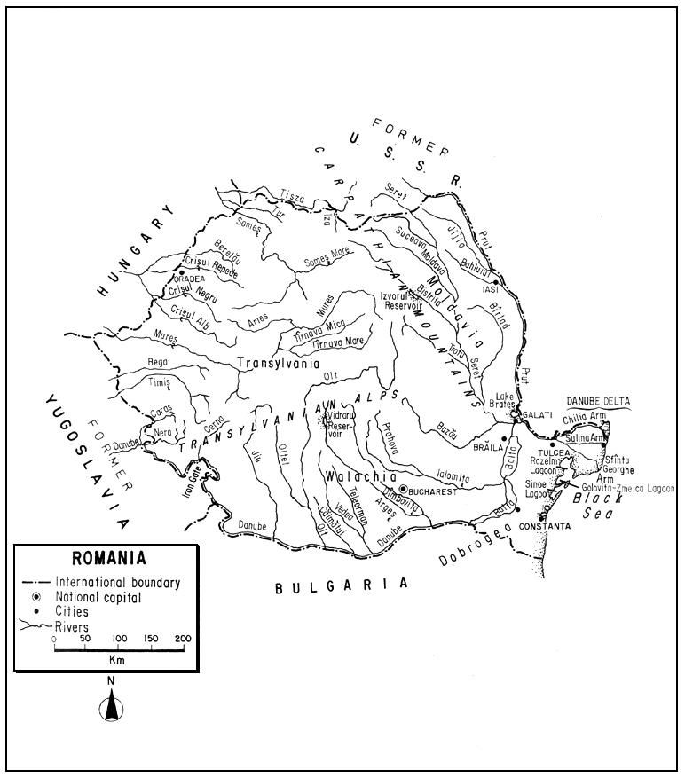
Romania, in southeastern Europe, with strong links to the Balkan region, has a core of high forested mountains, ringed by a zone of hills and plateaux above lowland plains which slope toward the Danube River and its great deltaic debouchement into the Black Sea. Moderately densely populated, this once predominantly agricultural, forested and mining country, has, under controlled economy, developed a burgeoning heavy industry and ever-increasing demands for water.
Despite the tremendous flow in the Danube itself, many of the streams fluctuate severely, the oligotrophic lakes are small in size and fishing in the eutrophic lakes subject to conflict with other land and water uses. Reservoirs are numerous and used extensively for fish production.
The Romanian inland fishery ranges from sport fishing for salmonids in the mountains to commercial fishing for warmwater species in overflow and deltaic areas and brackish water lagoons. The harvest from the Romanian inland fishery constitutes over 80 percent of the country's take from all of its freshwater, brackish, and marine territorial waters. Carp culture, which is traditional, is increasing in importance and is being supplemented by an ensemble of other species.
| 1. | AREA: | 237 500 km2 | |
| 2. | POPULATION: | 23 816 000 (est. 1990) | Density: 100 inh/km2 |
| 3. | PHYSICAL GEOGRAPHY | ||
Romania is situated between 48°15' and 43°37'N latitudes and 20°15' and 29°41'E longitudes in southeastern Europe.
Its extreme length is 789 km (E-W) and its greatest breadth is 475 km (N-S). Its altitudinal range is from 3.5 m below sea level to 2 545 m.
Romania is bounded on the north and northeast by the former USSR (Ukraine and Moldava) for 1 329 km, on the south by Bulgaria for 591 km, on the southwest by former Yugoslavia for 557 km, and on the northwest by Hungary for 442 km. It has an eastern coastline of 245 km on the Black Sea. The Danube River, forming major boundaries with Bulgaria and former Yugoslavia, flows for 1 074 km in Romanian territory; and the Prut River constitutes a boundary of 704 km with the former USSR.
Topographically, Romania consists of three major elements, each constituting about one third of the total area: a central range of mountains (over 800 m in elevation and averaging 1 200 m) surrounded by a succession of hills and plateaux (200–800 m), and a fringe of lowlands or plains (under 200 m). The central range, the Carpathians, enters from the north and swings southeast as the Eastern Carpathians, and then westward in a great are as the Southern Carpathians or Transylvanian Alps. Within the arc is the Transylvanian Basin and an isolated massif, part of the Western Carpathians. East of the arc is the Moldavian Plain, south of the arc is the Walachian Plain, and west of the massif is the Western Plain. The Walachian Plain merges into the floodplain of the Danube and the latter grades into the Danube Delta, the third largest delta in Europe, on the Black Sea. Lastly, confined between the Danube and the Black Sea is the Dobrogea, mostly steppe land but with a series of lagoons on its seaward side.
Alpine meadows and tundra occupy the highest elevations, but below about 1 800 m the mountains and hills are well forested with conifers (spruce and fir) and deciduous trees (beech and oaks). The treeless plain above the Danube is a waterless steppe-like grassland, now cultivated. The lowlands of the river contain old channels, lakes, and riparian vegetation, including willows, alders, poplars, and great reed beds. The Black Sea coast is sandy, well-indented and characterized by the presence of lagoons and littoral lakes.
The folded Carpathians are a medley of crystalline, sandstone, limestone, conglomerate and volcanics. Soils in Romania range from the stony skeletal soils of the high mountains to the chernozems of the plains. Their percentage values are: forest soils (56 percent), steppe and sylvo-steppe (31 percent), floodland soils (9 percent), marshy and saline (4 percent). The floodplains of the Danube, its delta and other bottom lands have a tendency toward salinization and water-logging.
4. CLIMATE
Transitional between temperate and continental, the climate is greatly affected by altitude. West of the Carpathians, the climate is milder than that of the east and south which is subject to scorching summers and winter blizzards.
The average annual temperature ranges from 10° to 11°C in the plains zone, 7° to 10°C in the hill zone, and below 60°C in the mountains. The average summer temperature is 21°C; the average winter temperature is -2°C. Extremes are 44° to -38°C. In the mountains, freezing begins in September and lasts over 200 days; in Transylvania it begins in October and lasts 100–150 days. The growing season is 180–210 days.
The average annual precipitation is about 670 mm, but ranges from 350–600 mm on the plains, 600–800 mm in the hills, and 800–1 400 mm in the mountains. The rainiest months are May–June; the driest is February.
The average depth of snowfall is 600–650 mm on the plains and low hills and about 2 m in the mountains. Snow cover lasts for about a month in the Danube Valley and three months in the mountains.
The lower Danube may freeze in some years; the probability of its advent in the Delta being 68 percent. At the head of the Delta it averages 43 days, at sea edge in Sulina it is 21 days (Vagin, 1970).
5. HYDROGRAPHY AND LIMNOLOGY
According to Morariu, Cucu and Velcea (1969, p. 142) the inland waters of Romania total more than 7 000 km2, thus agreeing with the estimate in Table 5 that they total about 7 160 km2 or about 3 percent of the total area of Romania. The first reference also indicates (p. 49) that the 2 500 Romanian “lakes” (including reservoirs and lagoons) do not appear to constitute more than 1 percent of the country's area. Europa (1988) states that inland waters constitute 8 600 km2 or 3.6 percent of the country.
The approximate annual runoff is 190 mm or 37 000 million m3. Added to this is about 155 000 million m3 received from upstream countries, resulting in a total annual river discharge leaving the country of 192 000 million m3 (Van der Leeden, 1975; ECE, 1978; Blaga, Filotti and Rusu, 1978).
5.1 Rivers (Rîu)
Almost all the rivers of Romania belong to the Danube (Dunărea in Romanian) catchment area draining outward from the Carpathian arc to the south and east - to flow directly into the Danube within the confines of Romania. The exceptions include a few northern and western rivers (e.g., Someş and Mureş) which reach the Danube indirectly through the Tisza in Hungary, and some minor Dobrogean streams that drain directly into the Black Sea. The lengths of the principal Romanian rivers are listed in Table 1.
The flow of the Danube is relatively stable, i.e., more so than that of the Romanian inland rivers. The latter have an uneven distribution on the area, and have great variations in runoff from year to year and within the year. The majority have a torrential flow regime: thus their maximum flows may reach several hundred or even 1 000 times that of their minimum flows. Within the country as a whole, spring is the season with the largest flow, with 40–60 percent of the total volume of flow occurring at that time. There are frequent floods as a result. The discharge of the Danube as measured near its entrance into Romania (Iron Gate) and near its mouth, as well as the discharges of other principal Romanian rivers is shown in Table 2.
Table 1
Principal rivers of Romania
| Name | Length (km) within Romania | Total | Name | Length (km) within Romania | Total |
| Danube | 1 074 | 2 860 | Tirnava Mare | 219 | 249 |
| Prut | 701 | 953 | Birlad | 217 | 217 |
| Mureş | 718 | 756 | Vedra | 213 | 213 |
| Siret | 592 | 726 | Crisul Alb | 226 | 238 |
| Olt | 699 | 699 | Moldova | 205 | 205 |
| Ialomiţa | 411 | 411 | Bega | 169 | 202 |
| Someş | 316 | 316 | Saharul | 198 | 198 |
| Jim | 319 | 319 | Tirnava Miča | 191 | 191 |
| Timiş | 211 | 316 | Nealov | 188 | 188 |
| Argeş | 310 | 310 | Oltei | 181 | 181 |
| Buzan | 334 | 334 | Teleorman | 178 | 178 |
| Jijia | 283 | 283 | Prahova | 169 | 169 |
| Bistriţa | 279 | 279 | Aries | 161 | 161 |
| Dîmboviţa | 266 | 266 | Calmǎtui | 155 | 155 |
Source: Rumanian People's Republic Central Statistical Board (1965)
The waters differ in their physico-chemical characteristics according to lithologic variations in their geographical zones. Thus, in the mountain zones formed by crystalline and eruptive rocks and rather insoluble limestones, the waters contain few mineral and organic compounds; their dissolved solids rarely exceed 200 mg/l. Rivers of the hills and plateaux with more sedimentary rocks range up to 500 mg/l, and on the plains their salt concentrations exceed 500 mg/l. Romanian rivers are predominantly bicarbonate, although the lower courses of a number of streams (especially in the southeast) are characterized by chlorides and sulphates. Organic loading rises during rains simultaneously with the bed loads transported from agricultural fields, and the mean value of suspended load transport for Romania is 1.88 t/ha/year.
Water temperatures, which follow the air temperatures closely, are lowest in December–January and highest in July–August. They are very high in some of the smaller lower streams during summer.
Table 2
Discharge of major rivers in Romania
| River and Station | Basin area km2 | Mean monthly discharge, m3/sec | Year | Period of record | |||||||||||
| Jan. | Feb. | Mar. | Apr. | May | June | July | Aug. | Sept. | Oct. | Nov. | Dec. | ||||
| Danube, Orsova | 576232 | 4464 | 4714 | 6403 | 7698 | 7632 | 6627 | 5533 | 4518 | 3911 | 3910 | 4762 | 4953 | 5427 | 1938–65 |
| Danube, Ceatal Izmail | 807000 | 5713 | 5768 | 6246 | 8437 | 8798 | 8330 | 7026 | 5356 | 4405 | 4147 | 5017 | 5758 | 6250 | 1928–65 |
| Someş, Satu Mare | 15000 | 86.5 | 166 | 214 | 241 | 150 | 124 | 86 | 55.6 | 35.7 | 38.4 | 60.4 | 107 | 114 | 1950–67 |
| Crişul Alb. Chisinea Criş | 3580 | 26.1 | 44.0 | 42.6 | 38.7 | 27.0 | 20.3 | 9.3 | 5.6 | 3.4 | 4.0 | 9.1 | 27.0 | 21.4 | 1950–67 |
| Arieş, Turda | 2399 | 17.4 | 23.4 | 36.0 | 53.2 | 40.8 | 28.2 | 18.7 | 12.8 | 8.8 | 9.0 | 12.5 | 21.0 | 23.5 | 1950–67 |
| Tîrnava Mare, Blaj | 3650 | 7.9 | 15.7 | 22.9 | 29.4 | 20.2 | 15.6 | 11.6 | 8.3 | 4.4 | 4.5 | 6.4 | 8.6 | 13.0 | 1950–67 |
| Tîrnava Mica, Tîrnâveni | 1468 | 5.7 | 9.4 | 14.1 | 18.8 | 12.1 | 9.3 | 7.4 | 5.9 | 2.9 | 3.2 | 4.3 | 6.4 | 8.3 | 1950–67 |
| Mureş, Arad | 27056 | 107 | 151 | 209 | 319 | 294 | 221 | 138 | 105 | 63.6 | 61.4 | 74.7 | 112 | 154 | 1950–67 |
| Timiş, Lugoj | 2706 | 30.6 | 42.4 | 44.6 | 61.9 | 63.1 | 44.2 | 24.6 | 19.5 | 10.9 | 11.4 | 17.5 | 30.1 | 33.4 | 1950–67 |
| Jiu, Podari | 9253 | 79.1 | 101 | 145 | 165 | 142 | 117 | 49.4 | 37.4 | 28.5 | 31.1 | 65.7 | 81.4 | 86.8 | 1950–67 |
| Olt, Izbiceni | 24203 | 101 | 104 | 238 | 251 | 300 | 236 | 122 | 93.4 | 68.3 | 97.2 | 108 | 97 | 151 | 1950–67 |
| Vedea, Cervenia | - | 14.8 | 17.8 | 30.3 | 21.2 | 10.7 | 11.7 | 4.7 | 3.5 | 2.9 | 2.6 | 5.2 | 9.4 | 11.2 | 1950–67 |
| Teleorman, Pielea-Teleorman | 1272 | 3.8 | 4.7 | 7.3 | 5.9 | 2.9 | 2.7 | 1.5 | 1.3 | 1.2 | 1.2 | 1.9 | 2.8 | 3.1 | 1950–67 |
| Argeş, Budeşti | 9229 | 40.5 | 45.0 | 65.8 | 90.6 | 106 | 91.7 | 41.5 | 26.8 | 14.3 | 15.3 | 27.0 | 33.0 | 49.7 | 1950–67 |
| Dîmbovita, Contesti | 1093 | 7.0 | 8.3 | 10.9 | 17.0 | 23.4 | 20.9 | 12.0 | 10.0 | 5.5 | 5.4 | 7.3 | 7.0 | 11.2 | 1950–67 |
| Ialomiţa, Sluhozia | 9154 | 35.0 | 38.9 | 55.7 | 69.9 | 64.2 | 57.2 | 30.6 | 22.3 | 16.1 | 16.8 | 26.2 | 29.0 | 38.5 | 1950–67 |
| Prahova, Adîncata | 3682 | 19.7 | 22.7 | 30.2 | 42.8 | 39.2 | 34.1 | 21.5 | 15.8 | 11.3 | 11.7 | 18.2 | 17.5 | 23.8 | 1950–67 |
| Siret, Lungoci | 36083 | 62.3 | 93.4 | 172 | 327 | 295 | 260 | 158 | 148 | 92.2 | 75.0 | 79.4 | 76.0 | 153 | 1950–67 |
| Moldova, Roman-Tupilaţi | 4028 | 9.1 | 11.4 | 23.3 | 52.8 | 50.0 | 46.0 | 33.1 | 39.7 | 17.8 | 12.3 | 11.4 | 10.2 | 26.2 | 1950–67 |
| Bistriţa, Cîrnu-Bicaz | - | 16.8 | 20.0 | 28.0 | 77.3 | 87.0 | 63.0 | 46.4 | 40.8 | 26.6 | 22.8 | 21.4 | 21.2 | 39.3 | 1950–67 |
| Bîrlad, Tecuci | 6778 | 4.3 | 9.9 | 18.0 | 13.2 | 6.0 | 8.6 | 3.2 | 2.6 | 1.7 | 1.9 | 3.5 | 3.5 | 6.4 | 1950–67 |
| Buzău, Săgeata-Banita | 3980 | 16.4 | 25.2 | 33.0 | 57.5 | 47.6 | 38.2 | 22.2 | 14.4 | 11.0 | 8.4 | 17.0 | 15.0 | 225.4 | 1950–67 |
| Prut, Ungheni | 15620 | 32.3 | 50.7 | 85.7 | 152 | 127 | 103 | 81.3 | 77.2 | 49.6 | 37.6 | 35.6 | 39.4 | 772.5 | 1950–67 |
| Jijia, Cîrpiţi-Victoria | 3350 | 1.6 | 4.7 | 10.1 | 9.9 | 3.0 | 4.7 | 1.7 | 1.5 | 1.2 | 0.9 | 1.2 | 1.1 | 3.5 | 1950–67 |
Source: Danube discharges from Van der Leeden (1975) after Unesco (1971). Discharges of other rivers from Diaconu (1971)
The mountain rivers typically have almost linear courses down steep slopes with rapid flow and sometimes through gorges. Clear and cold, they are primarily trout and grayling waters and secondarily cyprinid. Rivers of the hills and plains, more winding often shallow, silty, and subject to great variations in flow and temperature, also harbour cyprinids, as well as pike (Esox lucius) and European catfish (Silurus glanis). The rivers of the plains which are very meandered, often dry out into strings of small ponds (mostiste) in the summer, and many small dams are built to hold water (see section 5.3). Many of the streams tributary to the Danube are fringed with marshes and lakes in their lower courses.
5.1.1 The Danube River and its Delta
The Danube River has a total length of 1 074 km in Romania. Of this length, 297 km forms a boundary with former Yugoslavia and 453 km a boundary with Bulgaria. A smaller portion of the main Danube and one of its distributaries (Chilia) separates Romania from the former USSR. In addition to its major channel, the Danube has a number of arms over 700 km in length, and its entire surface area within Romania is over 50 000 ha.
The upper part of the Romanian Danube is narrow. Above the Iron Gate it flows between 3.5–18 km/h. It then flows across a wide plain where its velocity varies from 1.6 to 4 km/h, its width from 40 to 1 210 m, and its depth from 1.5 to 9 m. On the Bulgarian side, there are undercut bluffs and hills, but on the lower Romanian side the braided river parallels the low plain from which it is separated by dams, lakes and swamps. From the point where it turns north from the Bulgarian border to Braila, it has two main arms enclosing great dammed areas. Near Tulcea, it starts to spread and finally empties into the Black Sea through three distributaries: (i) the northern Chilia arm, 100 km long and carrying 65 percent of the flow; (ii) the central Sulina arm, 83 km long carrying only 14 percent of the flow, but dredged to 7 m for navigation, and (iii) the southern Sfintu Gheorghe arm, 120 km long with 22 percent of the flow.
The Danube also has a zone of innundation of more than 9 000 km2 within Romania. About half of this area which lies upstream is termed the “Lunca” or “Balta”; more than 90 percent of this area is diked. The rest lies downstream in the Delta proper. There is both a natural fishing zone and a number of lakes and diked ponds where fish are reared, and most of the delta is kept in a natural state for wildlife.
The Romanian Danube reaches a summer temperature of 22–24°C and can be classed as a cyprinid zone.
The Delta proper, starting about 150 km from the Black Sea at Galati, has an area of about 3 430 km2 in Romania. Supplied by an annual load of about 57 million m3 of silt, the Chilia and Sulina are growing seaward at a rate of about 25 m annually. Never more than 6 m above sea level, and with a considerable portion below sea level, it is a complex of reed-filled marshes (62 percent), streams and ponds (25 percent) and sandbanks (13 percent). Many secondary branches, streams and canals link the river with numerous lake complexes and marshes. The largest lakes are: Gorgova, Fortuna, Matita, Merheiul, Isacova and Roşu. (See also section 5.2.) Some 100 000 ha are given over to areas of partly floating plant material.
The entire deltaic area, which holds an average of about 2 230 million m3 of water, is constantly changing with variations in flow, water level, and siltation. Most of the area, which averages only 0.54 m in elevation, is inundated during the period of maximum discharge in late spring and early summer. The most important inland fisheries of Romania are centred here.
Based upon the size of the deltaic area concerned with each use, fisheries use 67.7 percent inclusive of the Razelm-Sinoe complex, reed exploitation 7.2 percent, agriculture 7.2 percent, forestry 5.2 percent, grasslands 6.8 percent and other uses 5.9 percent.
In addition to the Delta proper, there is a lagoon area, the Razelm-Sinoe complex, of 990 additional km2 fed by the Danube (see section 5.2).
5.1.2 Other Rivers
In addition to the dominating Danube, Romania has over 4 000 rivers having watersheds larger than 10 km2 and a total length exceeding 60 000 km. These rivers can be separated into six groups of hydrographic systems:
Northern. This group includes small streams such as the Vişeu, Iza and Tur, which form part of a drainage culminating in the main Tisza in Hungary.
Western. Included here are the much larger river systems, the Someş, forks of the Criş, Mureş and Bega, all of which originate in Romania but join the main Tisza in Hungary.
Southwest. The Timiş, which joins the Danube in former Yugoslavia and the Caraş, Nera and Cerna, which join the Danube in Romania, form this group.
South. Draining out of the South Carpathians across the Walachian Plain are the large rivers, the Jui and the Olt, the Vedea, Argeş, its tributary the Dîmbovita, and the lalomiţa and its tributary the Prahova. Some of the eastern Walachian streams lose much water in the summer and may even disappear.
Eastern. The Siret and its tributaries, Suceava, Moldova, Bistrişa, Birlad and Buzău, furnish most of the silt that builds the Danube Delta. The Prut, shared with the former USSR, and navigable for about 322 km, has only one large tributary, the Jijia.
Dobrogean. Some of these small streams (e.g., Cocargea and Topolog) drain into the Danube; others (e.g., Teliţa, Casimcea) join the Black Sea directly.
5.2 Lakes and Lagoons (Lacs)
There are said to be about 2 500 “lakes” in Romania but this figure apparently includes the brackishwater lagoons as well as reservoirs (see section 5.3). They do not appear to constitute more than one percent of the country's total area, and few exceed 50 km2 in area. A list of the principal natural lakes and lagoons of Romania appears in Table 3.
In depth, these waters range from deltaic lakes of only 2 or 3 m to Alpine lakes more than 20 m deep (e.g., Zanoaga and Tăul Negru).
The mountain lakes are mostly glacial, oligotrophic and of small size; there are over 150 cirque lakes mostly in the Southern and Eastern Carpathians. The largest mountain lake is Bucura (10 ha). There are also some landslide lakes (e.g., Lacu Roşa and Bălătău) and one crater lake, Sfinta-Ana, in the mountains.
Most of the lakes on the plateaux are artificial reservoirs. Some have also formed in natural or manmade excavations in salt-deposit regions.
There are numerous lakes on the floodplains of the larger rivers (especially the Danube) or at the mouths of some rivers (“fluvial estuaries”), or in hollows resulting from subsidence. These are eutrophic and often have abundant aquatic vegetation.
Finally, there are the large coastal or lagoon lakes - products of both fluvial and marine action some primarily fresh and some quite saline. These lagoons generally have a good deal of free water and their emergent vegetation is limited to the shores. Separated by dunes from the sea, some may be open to it at times. Adjacent to the Delta proper is the large Razelm-Sinoe complex of about 990 km2 with several divisions: Razelm, Sinoe, Zmeica, Golovita, Babadag and Tuzla. Razelm, considered the largest “lake” in Romania, is only 3 m deep. Fed by canals from the Danube (see section 5.4). South of this network are other areas of static water, some fresh (Taşaul, Siutghiol), some brackish (Mangalia) and some saline (Techirghiol).
Table 3
Principal natural lakes and lagoons of Romaniaa
| Lake | Type | Location | Area km2 |
| Razelm | Sea lagoon | Tulcea | 415.0 |
| Sinoe | Sea lagoon | Constantza | 171.0 |
| Zmeica | Sea lagoon | Tulcea | 54.0 |
| Babadag | River and sea lagoon | Tulcea | 25.0 |
| Mostiştea | River lagoon | Cǎlǎrasi | 20.0 |
| Siutghiol | Sea lagoon | Constantza | 20.0 |
| Dranov | Water meadow | Tulcea | 20.0 |
| Taşaul | River and sea lagoon | Constantza | 18.0 |
| Techirghiol | River and sea lagoon | Constantza | 12.0 |
| Snagov | River lagoon | Bucharest | 5.8 |
| Amara-Slobozia | River lagoon | lalomita | 1.5 |
| Sfinta-Ana | Crater lake | Harghita | 0.22 |
| Lacu-Roşa | Landslide lake | Harghita | 0.12 |
| Bucura | Glacial lake | Hunedoara | 0.10 |
Source: Rumanian People's Republic, Central Statistical Board (1986)
5.3 Reservoirs (laz)
It is believed that reservoirs for water storage were contructed in Romania as long ago as Roman times (second century A.D.), and there is documentary evidence of artificial lakes in the 15th century. Their present distribution was determined not only by the individualities of the hydrographic network, but by the development of industrial potential equalization.
Table 4 shows the artificial lakes (including controlled natural lakes) in Romania as of 1968. They totalled 1 192 in number, had a surface area of 47 548 ha and a capacity of 2 477.5 million m3.
The greater number of these (about 1 100) were reservoirs especially dammed for irrigation and fish culture and also used for flood control. Most reservoirs in this group had areas of only 1 to 50 ha; a few were as large as 400 ha. They are found mainly in the plateau and plain areas, but on the floodplains of the large rivers, diking of overflow zones and the drying up of natural lakes has resulted in the development of reservoirs for the same purposes.
There were also about 50 reservoirs, mostly in mountain areas, developed for hydroelectric power and drinking and industrial water. Some of these have become important tourist centres and support fisheries. The largest of these is Lake Izvorul Muntelui on the Bistriţa River; it is 35 km long, has an area of 3 250 ha, is 90 m in depth, and has a capacity of 1 230 million m3. Below it are eight smaller reservoirs with a combined storage of 52.4 thousand m3. Another large reservoir is Lake Vidaru on the Argeş River with a dam 167 m high, an area of 865 ha and a capacity of 465 million m3. There are a number of smaller associated reservoirs in the same drainage basin.
The most important reservoir development in recent years (1972) was completion of the Djerdap High Dam on the Danube at Iron Gate to create a reservoir over 150 km in length and the downstream Iron Gate II dam which impounded a 8 000 ha reservoir about 80 km long. The scope was to develop power shared by Romania and former Yugoslavia. Romania and Bulgaria are proposing the construction of another barrage on the Danube below the mouth of the Olt (Turnu-Măgurele/Nikopol), but because of economic difficulties construction has been postponed.
Most of the above information, including Table 4, is taken from Gâştescu and Breier (1973), and (as has been explained before) about 1 100 of the 1 192 artificial lakes they listed are small reservoirs in valleys dammed for the purpose of fish culture and agriculture. In a more restricted classification, Blaga, Filotti and Rusu (1978) listed the number and capacity of the greater reservoirs on Romanian inland rivers as follows:
| 1975 | 1980 | 1990 | Long-term | |
| Number of reservoirs | 100 | 170 | 550 | 1 400 |
| Capacity (million m3) | 3 700 | 6 900 | 22 000 | 34 000 |
They went on to say that from the total long-term value of 34 000 million m3, 24 000 million m3 would be the volume allocated to water demands of users, yield hydroelectric power and create water levels for navigation and fish breeding. The other 10 000 million m3 would be used for flood damping. In order to accomplish this, interconnexion of large water courses and water transfer between basins would be necessary. In 1975, there were only about 100 km of canals, galleries, and drains, but 2 000 km of conduits would be necessary under the long-term plan to transfer over 3 000 million m3 of water to water-deficient areas. They also envisioned an emphasis on “fish-breeding” with establishment under a national programme of new fisheries in small ponds, lakes and nurseries with a total surface of 140 000 ha, and piscicultural operation of water bodies created by reservoirs of permanent capacity reaching 230 000 ha. They also pointed out that the large reservoirs built to meet user's demands would also be used for fish production although water-level fluctuation would not permit intensive use.
In 1990 the surface of Romanian fished reservoirs was 53 137 ha. The area under fish culture was hatcheries 15 145 ha; ponds 75 428 ha, of which 7 158 ha and 42 133 ha respectively are in the delta1.
Gâştescu and Breier (1973) distinguish between “reservoirs (iaz in Romanian)” as lakes formed by the construction of a dam across a valley, and “fish ponds (elesteu in Romanian)” as basins, regardless of their size, constructed in flat areas and encircled by dams. But both are apparently held by them to be “artificial lakes”. Similar terms are not defined by the other authors.
Table 4
Artificial lakes in Romania grouped according to hydrographic basins (1968)
| Basin | Lakes for hydropower generation | Lakes for fish culture and agriculture (irrigation) | Lakes for other usesa | Total | ||||||||
| No. | Area, ha | Volume million m3 | No. | Area, ha | Volume million m3 | No. | Area, ha | Volume million m3 | No. | Area, ha | Volume million m3 | |
| Upper Tisa | 1 | 0.12 | ... | 1 | 0.12 | ... | ||||||
| Someş-Crasna | 7 | 291.60 | 3.5 | 1 | 131.0 | 17.6 | 8 | 422.60 | 21.1 | |||
| Crisuri-Bereteu | 17 | 1515.10 | 28.7 | 17 | 1515.10 | 28.7 | ||||||
| Mures-Aranca | 1 | 2.0 | 0.15 | 17 | 378.95 | 6.6 | 1 | 261.0 | 43.5 | 19 | 641.95 | 50.25 |
| Bega-Timis-Caras | 2 | 71.0 | 11.90 | 19 | 474.75 | 7.8 | 5 | 1113.6 | 15.0 | 26 | 659.35 | 34.7 |
| Nera-Cerna | 2 | 1.01 | 0.1 | 2 | 1.01 | 0.1 | ||||||
| Jiu | 10 | 22.20 | 1.8 | 2 | 2000.0 | 100.8 | 12 | 2022.20 | 102.6 | |||
| Olt | 2 | 39.0 | 6.5 | 25 | 245.95 | 8.3 | 7 | 25.0 | 1.3 | 34 | 309.95 | 16.1 |
| Vedea | 123 | 1388.00 | 25.0 | 123 | 1388.00 | 25.0 | ||||||
| Arges | 3 | 946.0 | 473.8 | 133 | 3453.00 | 34.6 | 10 | 1500.0 | 44.0 | 146 | 5899.00 | 552.4 |
| Ialomiţa | 1 | 21.0 | 0.55 | 91 | 1649.70 | 33.2 | 1 | 6.0 | 0.8 | 93 | 1676.70 | 34.55 |
| Siret | 8 | 4545.0 | 1282.0 | 104 | 4184.00 | 26.1 | 2 | 360.0 | 18.2 | 114 | 9089.00 | 1326.3 |
| Prut | 281 | 9374.00 | 91.4 | 6 | 722.0 | 16.0 | 287 | 10096.00 | 107.4 | |||
| Danube | 255 | 10069.00 | 108.0 | 42 | 1060.0 | 25.3 | 297 | 11129.00 | 133.3 | |||
| Coastal | 13 | 2698.00 | 45.0 | 13 | 2698.00 | 45.0 | ||||||
| Total | 17 | 5624.0 | 1774.90 | 1098 | 35745.38 | 420.10 | 77 | 6178.6 | 282.5 | 1192 | 47547.98 | 2477.50 |
a Including water supply, flood control and recreation
Source: Gâsteşcu and Breier (1973)
5.4 Canals
Aside from the irrigation canals, canalized natural rivers, and connexions between the Danube and various arms and lakes, the most important canal in Romania is the Danube-Black Sea Canal which was officially opened in May 1984. This 64-km canal from Cernavoda to Constanta lessens the journey down the Danube to the Black Sea by several hundred kilometres. It will accommodate ships, power from stations at its two locks, and contribute to the irrigation of 220 000 ha (Economist, 1984). A Danube-Bucharest Canal was under construction in 1987 (Europa, 1988).
5.5 Coastal Waters
The Black Sea which borders for 245 km on Romania is the largest meromictic basin in the world. With a permanent halocline, it is filled with stagnate anoxic water containing hydrogen sulphide below a depth of 80 to 200 m. Hence its productivity is limited. See the section on Turkey, and especially Zenkevitch (1963) for a description.
The coastal waters of the Romanian sector of the Black Sea are characterized by having a lower salinity than that of the main Black Sea, and by rapid changes in both temperature and salinity dependent upon wind direction. The salinity may vary from 10 to 20 ppt within a few days. Near the coast, the mean annual surface temperature is about 12.5°C. In summer, it often rises to 25°C and in winter the Sea may freeze for several kilometres offshore.
Freshwater fish are found at times along the coast, especially in summer, as far south as Bulgaria (where the salinity is higher), being influenced by winds from the north which bring warm water of low salt content. Conversely, marine fishes may at times arrive at the Delta and penetrate the lagoons (e.g., Zatonus Mare).
6. LAND AND WATER USE
Table 5
Pattern of land use in Romania, 1987
| Percent | |
| Arable and permanent crops | 45.0 |
| Permanent pasture | 18.6 |
| Forests and woodland | 27.6 |
| Other land | 5.3 |
| Inland water | 3.5 |
| Total | 100.0 |
Source: 1988 Annuar.Statistic.al R.S.Romania, Dir.Centr.de Statistics
The economy of Romania, and therefore the use of land and water, is partly socialized. The State has owned all natural resources other than collective and private farm lands, and a great part of agricultural land is held by cooperative and State farms.
Formerly based on agriculture, forestry and oil production, the economy is now dominated by mostly nationalized industry. Nevertheless, Romania's land use is still largely agricultural, and the country is about 28.6 percent rural (1988 Annuar Stat.). Romania is a great granary for cereals; sugar beets, vines and fruits are important crops. There is also sheep grazing and a considerable cattle industry.
The low precipitations of summer and their uneven distribution during the growing season, low humidity and frequent strong winds are all factors demanding irrigation on the tablelands and plains. A shift to the use of large holdings and intensive agriculture, including fertilization (although still well below the European average), has further increased the use of irrigation. By 1987, the irrigated area (3.37 million ha) represented about 33 percent of the cultivated area, i.e., about 12.6 percent of the entire country. About 50 percent of the farming area requires irrigation, and it is planned to irrigate 5.1 million ha. Pump and gravity flow will supply this water, and a network of small dams is rapidly covering the eastern and southern areas of the country.
Large-scale irrigation is comparatively new, but large drainage systems have existed since the 18th century on the Western Plain. Circa 1969, an area of 2.8 million ha or 20 percent of the farming land was served by drainage works, and about 1.3 million ha had been drained. The areas have been developed by complex embankments and most of the water is removed by pumping. Many fish producing areas have thus been destroyed.
The Danube's floodplain was kept under a natural flood regime up to the end of the last century used primarily for fishing and secondarily for grazing, timber production and farming. Following an extensive programme of diking, reed removal and drainage, a permanent water area of about 60 000 ha had been restricted to about 8 200 ha for fish production. Framji and Mahajan (1969) claim that the total fish output remained the same.
Forestry and timber processing continue to be large industries, roundwood production being about the fifth highest in Europe. Most of the forests are high-montane (conifers) but deciduous trees are also harvested. In the Delta there was a great reed-growing area of over 270 000 ha where the reeds (Phraqmites communis) were cut for cellulose during the low-water periods, sometimes in connexion with fishing operations. The surface area of the reeds has been drastically reduced. At one time, a considerable number of small ponds (hait) were constructed along mountain rivers to furnish water for the transport of log rafts. Road construction has made them obsolete, although logs are still floated on some rivers such as the Mureş. Forests, generally, have decreased in Romania but there is a reforestation programme partly to improve watersheds.
Mining is also an old industry in Romania. There is coal, iron, various non-ferrous minerals, natural gas and a large oil production. Some of the earliest man-made lakes in the mountains were built for ore separation.
Industry, which is now concentrated on its heavy elements, includes iron, steel and machine manufacturing, metallurgy and chemicals. The newer, larger dams in Romania are constructed especially to provide water and power for these industries.
Mining, oil and the chemical industry are major sources of water pollution and localized areas may be found throughout the country where severe conditions exist. The main Danube has water of reasonably good quality except in areas of industry (e.g., steel, cellulose). Groundwater has limited use (about 8 percent) in Romania, thus increasing the demands on surface water for all uses.
In 1987 the total installed electrical capacity of Romania was 74 079 000 kW of which 11 209 000 kW (15 percent) was hydroelectric. Most of the hydroelectric dams have been constructed since 1950 and many more projects are planned for mountain rivers. Those of the south, the Olt and Siret, have considerable potential. It has been estimated that at least 71 rivers are suitable for hydroelectric plants (Bossy, 1957). The use of thermal power (gas and coal) is also increasing, and there is some nuclear power in project. Romania shares a power grid with Bulgaria, Czechoslovakia and former Yugoslavia.
Auto roads have a low density in Romania, only 0.31 km/km2 in 1985, and passenger car ownership is extremely low, only about 10 per 1 000 people (1979). Aside from a network of railways about 11 300 km, there are about 2 400 km of navigable streams in the country. The Danube and the lower Prut rivers are the most important, and the lower Mureş, part of the Siret, and the Bega (Canal), which runs into former Yugoslavia, are also navigable. Ice stops the Danube traffic for about one month in most years. Dredging is necessary to maintain navigation; and pollution from river craft may affect fisheries adversely. An International Danube Commission, formed in 1948, ensures free navigation and management from the mouth of the River to Ulm in Germany.
Fisheries and fish culture have long been recognized as important uses of the country's waters, being the most important branch of food production next to agriculture (Motley, 1970). Romania's commercial fishery on the Danube far exceeds that of the other Danubian countries and its inland fisheries exceed its Black Sea fisheries. For direct human consumption, the per caput supply of fish is about 9 kg/year (1982–84). Sport fishing is achieving importance as both tourism and industry grows (see section 7).
With respect to overall water use, both industry and agriculture use large quantities in this relatively water-deficient country. Circa 1968, when the total water consumption in Romania was only about 5 400 million m3 annually, industry used 65 percent of the supply, irrigation 20 percent, and domestic supply 15 percent (Chiriac, 1968). Over one half of the groundwater is already used, and water demands (which will obviously be answered primarily from surface resources) are calculated to rise from 22 400 million m3 in 1980 to 46 000 million m3 in the long term (Blaga, Filotti and Rusu, 1978).
Tourism is moderate: about 6 million people visited Romania in 1985.
![]()
![]()
![]()