![]()
![]()
![]()
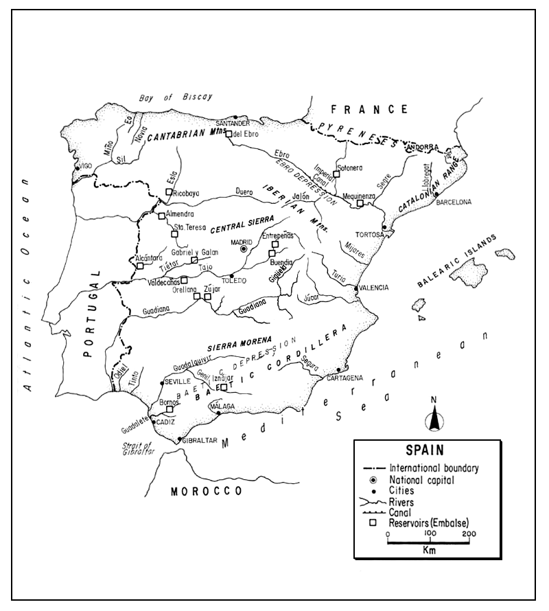
The Spanish State, the second largest country in Western Europe, occupies 85 percent of the lberian Peninsula which it shares with its western neighbour, Portugal. It is cut off from, the rest of Europe by the towering Pyrenees on its French border. On the north and northwest is the Atlantic; its southern and eastern shores front on the Mediterranean. Most of Spain's great interior is occupied by a high and arid plateau, the Meseta, compartmentalized by mountain ranges and river valleys.
Only moderately densely populated, Spain is primarily an agricultural country greatly dependent upon irrigation. This has reduced its stream area for fish, but the construction of many reservoirs for both irrigation and hydroelectric use has increased its static water areas. Spain is almost lacking in freshwater lakes except for some high mountain tarns. Its streams are subject to great variations in flow, thus lessening potential for inland fishing. Nevertheless, northern Spain possesses a number of rivers which provide the southernmost Atlantic salmon fishing in Europe.
A strong tradition for marine fish consumption, as well as basically unfavourable water conditions have lessened development of its inland fisheries. Trout aquaculture has, however, increased of late, promotion of its inland sport fisheries for both warm and cold-water fishes continues, and efforts are being made to improve its brackishwater production through intensive aquaculture.
| 1. | AREA: | 504 750 km2 (Continental Spain: 492 463 km2)1 | |
| 2. | POPULATION: | 39 748 000 (est. 1990) | Density: (total) 79 inh/km2 |
| 3. | PHYSICAL GEOGRAPHY | ||
Spain, situated between 43°47' and 36°N latitudes and 3°19'E and 9°30'W longitudes, occupies about 85 percent of the lberian Peninsula. Its greatest east-west extent is 1 075 km, its greatest north-south extent is 866 km. Ranging in elevation from sea level to 3 478 m, its mean altitude is 610 m, higher than that of any other European state except Switzerland. Rising sharply from the sea, about 60 percent of Spain is over 600 m, and only 11 percent under 200 m (the official Spanish designation for hills).
Spain is bounded on the north for 867 km by the Cantabrican coast (the Atlantic Ocean's Bay of Biscay), and by a border (the Pyrenees Mountains) of 712 km with France, on the east and south by the Mediterranean Sea (1 670 km), and on the west by the Atlantic Ocean (1 367 km), and a border of 1 232 km with Portugal2. The minute principality of Andorra is on the Spanish-French border (see Andorra), and there is a 1-km boundary with the enclave of Gibraltar (a British self-governing dependency) at the entrance to the Mediterranean Sea. At this point, Spain is separated from Africa by a strait only 15 km wide.
2 Length of boundaries from Anuario Estadístico de España, 1989
Physiographically, Spain consists primarily of: (i) a massive crystalline block or plateau, the Meseta: (ii) two great river valleys, the Ebro and Guadalquivir, bordering the Meseta; (iii) a large series of peripheral mountains, and (iv) a generally narrow coastal zone lacking islands.
The Meseta. Occupying about one-half of Spain, and averaging 670 m in elevation, the Meseta consists mainly of a series of barren, hot and often arid plains, titled generally to the west. It is crossed by a Central Sierra of granites and schists, tending northeast to southwest, which reaches 2 100 m, and divides the entire area into the higher northern tablelands of Leon and Old Castile and the much larger, but lower, New Castile which is bounded on the south by the uptilted edge of the Meseta, the Sierra Merena. Meseta rivers in general flow sluggishly across it and may be reduced to trickles within broad flood areas. The three largest, the Tajo, Duero, and Guadiana originate in the east and flow westwardly across the plateau to the Atlantic (see section 5.1).
The Ebro and Baetic Depressions. Bordering the Meseta on the northeast is a great transverse depression forming a deep ravine between the tableland and the Pyrenees. It is now occupied by the Ebro River flanked on the southwest by the high and barren lberian Mountains. Fresh water is scarce and the springs have a high mineral content. The Baetic, an even greater depression, lies to the south of the Meseta. Its bed, deeply eroded by the Guadalquivir River, forms the fertile valley of Andalusia before emptying into the Mediterranean. This is the only important lowland area in Spain communicating directly with the sea.
Peripheral Mountains. Outside the border of the Meseta are the following great mountains:
Pyrenees. These form a continuous wall, 420 km long and 100 km wide, between Spain and France. With an average altitude (of about 1 500 m) higher than the Alps, they range to 3 406 m. Both crystalline and limestone, they have a few small glaciers and lakes, and their streams cut deep gorges.
Cantabrians. Almost as impressive as the Pyrenees are their western extension, the limestone Cantabrian Mountains which parallel the northern coast of Spain and merge eastwardly into the lower Galician Mountains of schists, slates and granites.
Iberian Mountains. Continuing down from the Cantabrians as far as the Mediterranean coast, the folded Iberians form the eastern rim of the Meseta and separate it from the Ebro depression to its east.
Catalonian Range. The seaward end of the Ebro basin is almost closed by a series of ridges, the Catalonians, through which the Ebro River has cut a passage to the Mediterranean.
Ponibaetic System. To the southeast of the Meseta is the Baetic Cordillera, consisting of a northern limestone and a southern crystalline belt. The highest peak in Spain (3 478 m) is part of this system. The Sierra Nevada part of this system is completely Alpine with glacial cirques, lakes, and moraines. Rock types vary from limestone and sandstone to igneous intrusions.
Coastal Regions. The 3 904-km coast of Peninsular Spain, generally narrow except in the north and northwest, rises sharply from the sea. The northern coast extends for 867 km from France to the extreme northwest where it is characterized by its rias, the mouths of submerged river valleys. The Mediterranean side of Spain consists of a series of isolated beaches and a few bays, with its mountains rising close to the sea. There are some lagoons (see section 5.4) but many of these have silted up or become marsh land.
Broadly speaking, Spain has two main types of contrasting surface deposits: (i) siliceous or crystalline rocks (granites, schists, quartzite), in the west, and (ii) limestone, clay and sand in the east. These characteristics are reflected in two general limnological zones, the eastern waters having a higher mineral content. Shallow silty soils are found over most of the Meseta, podsols in pluviose (northern) Spain, and pedocals in the drier and warmer areas.
About half of Spain is semi-arid. Mattoral (thorny bushes or evergreen plants) is a characteristic feature of the natural vegetation especially of the central tablelands, and steppes also occupy broad areas. Although about one-quarter of the country is forested, in the arid plateau the forest is mainly confined to watercourses and the wetter mountain slopes. Most of the forests are pine, and deciduous trees (oaks, beech, birch, ash) are practically confined to the pluviose zone of the north and northwest. Subalpine vegetation is found at the highest elevations. Thus, due to the wide climatic range, the natural vegetation ranges from central European and Alpine to African, while cultivated vegetation such as citrus is often luxuriant in the southern irrigated areas known as huertas.
4. CLIMATE
Basically Spain has three types of climate corresponding with three general geographical zones: (i) temperate pluviose climate in the northwest and north with moderate temperatures and year-round abundant rain; (ii) arid (locally generated) continental climate of the interior with cold winters, hot dry summers and irregular rainfall, and (iii) Mediterranean climate of the south and east coasts and Andalusian lowlands with mild moist winters and very hot dry summers and sometimes torrential rainfall.
The north coast has an average annual temperature of about 14°C (range about 9°–18°C). Madrid as an example of the interior (where the climate is also sometimes termed “sub-Mediterranean”) has an average annual temperature of about 13°C but a seasonal average ranging from 4.4°C (December–January) to 25°C (July–August) with extremes of -10° and 39°C. In Seville (southwestern Spain) the average annual temperature is about 20°C the average seasonal range is 11°–30°C and the extremes -2.7° and 50°C. Valencia on the Mediterranean coast has an average seasonal range of 10° to 25°C.
The rainfall throughout Spain is even more variable. The total annual average rainfall over the entire country is 682 mm but over half of the country has an annual average less than 500 mm and only 20 percent averages more than 1 000 mm per year. Annual rainfall in part of the pluviose northwest coastal region is 1 600 to 2 400 mm. On the central plateau it is about 350–750 mm. In one of the drier areas (southern coast) it is only 150 mm1.
North of a line extending from Lisbon to Madrid and Tortosa snow falls most winters and the Meseta may have 10 to 30 days of snow. South of this line snowfall is almost unknown on the coast. There is perpetual snow on the high peaks and the highest passes in the Pyrenees are open only four months of the year.
5. HYDROGRAPHY AND LIMNOLOGY
Table 5 indicates that the total inland water area of Spain is only 5 340 km2 or 1.06 percent of the country's total area. The original basis of this figure is unknown but it is certain that the total amount of Spain's surface water is very small. Europa (1988) basing its information on Spain's Instituto Nacional de Estadística says that Spain's inland water covers 5 240 km2 or 1.04 percent of the total country. The predominant inland waters are rivers and their man-made lakes or reservoirs. There are also a number of small natural mountain lakes, many salt ponds and a few large coastal lagoons.
The average annual run-off from rainfall in Spain is 153 mm or 76 000 million m3. Almost no runoff is received from upstream countries (there is some from Andorra) so the total annual river discharge from this source leaving Spain is still only about 76 000 million m3 (Van der Leeden, 1975; ECE, 1978)2.
The drainage is primarily Atlantic and secondarily Mediterranean. Rivers in the north drain directly to the Atlantic. The tableland and interior slopes of its peripheral mountains drain west and south to the Atlantic as does the plain of Andalusia. Thus the main watershed is the lberian Mountains and the Ebro which drains to the Mediterranean collecting water from the Pyrenees. Table 1 illustrates the major hydrographic basins in Spain.
Table 1
The ten major hydrographic basins of Spain
| River basin | Basin area (km2) | Annual rainfall (mm) | Average annual surface runoff (million m3) |
| Atlantic drainage | |||
| Northern and northwest | 54 430 | 1 360 | 32 000 |
| Duero | 79 330 | 610 | 8 150 |
| Tajo | 56 750 | 640 | 7 525 |
| Guadiana | 60 270 | 530 | 3 895 |
| Guadalquivir | 61 060 | 600 | 4 800 |
| Mediterranean drainage | |||
| South coastal | 20 860 | 500 | 1 900 |
| Segura | 16 160 | 430 | 580 |
| Jucar | 43 090 | 510 | 2 250 |
| Ebro | 86 000 | 600 | 14 000 |
| Catalan (Pyrenees Orientale) | 16 500 | 740 | 1 200 |
| Total or average | 493 500 | 670 | 76 300 |
Source: Van der Leeden (1975) after Llamas (1967) and Dirección General de Obras Hidráulicas (1971)
5.1 Rivers (Ríos)
Spain is reported to have about 1 800 rivers and streams, all but 90 are less than 160 km in length and many of them are dry at least in part most of the year. There are about 72 000 km of permanent rivers (Spain/EIFAC, 1977) a statement probably based on the 70 000–75 000 km cited by De Rada (1954).
The principal rivers of Spain are tabulated in Table 2, and the mean monthly discharges of four major rivers are shown in Table 3.
The pattern of seasonal rainfall (see section 4) coupled with a high evaporative rate in the summer and rapid run-off from steep, often barren, slopes makes the flow of Spanish rivers extremely irregular. The average ratio of maximum and minimum flows varies from two to eight, but often the differences are much larger. For example, in the Ebro, the flow is generally 45 times as great in January as in August, and the ratio between the absolute maximum and absolute minimum is in excess of 1 000 to 1. Following heavy showers in some northern brooks, the flow per second has been higher than the average hourly flow per year. As a third example, floods come in late winter and spring followed by low water. Thus the Tajo at Aranjuez diminishes from 2 094 m3/sec to 85 m3/sec.
Table 2
Principal rivers in Spaina
| Basin and river | Length (km) | ||
| 1. | Northern (Cantabrian) basin | ||
| Bidasoa | 67 | ||
| Nervión | 69 | ||
| Sella | 56 | ||
| Nalón | 129 | ||
| Navia | 159 | ||
| Eo | 79 | ||
| 2. | Northwest (Galician) basin | ||
| Ulla | 126 | ||
| Tambre | 134 | ||
| Miño | 310 | ||
| Sil (trib. to Miño) | 225 | ||
| 3. | Duero basin | ||
| Duero | 895 | ||
| Adaja | 163 | ||
| Tormes | 247 | ||
| Pisuerga | 275 | ||
| Esla | 275 | ||
| 4. | Tajo basin | ||
| Tajo | 1 007 | ||
| Jarana | 194 | ||
| Alberche | 182 | ||
| Tiétar | 170 | ||
| Alagón | 201 | ||
| 5. | Guadiana basin | ||
| Guadiana | 778 | ||
| Jabalón | 153 | ||
| Matachel | 124 | ||
| Ardila | 116 | ||
| Giguela | 194 | ||
| Zújar | 210 | ||
| Záncara | 168 | ||
| 6. | Other Western Atlantic basins | ||
| Odiel | 121 | ||
| Tinto | 93 | ||
| Guadelete | 79 | ||
| 7. | Guadalquivir basin | ||
| Guadalquivir | 657 | ||
| Guadiana Menor | 94 | ||
| Guadaioz | 114 | ||
| Genil | 337 | ||
| Guadaira | 89 | ||
| Guadalimar | 167 | ||
| 8. | South Coastal basin | ||
| Almeria or Andarax | 62 | ||
| Adra or Grande | 47 | ||
| Guadalfeo | 72 | ||
| Guadalhorce | 154 | ||
| Guadiaro | 79 | ||
| 9. | Levantine basin | ||
| Mijares | 156 | ||
| Turia or Guadalaviar | 280 | ||
| Júcar | 498 | ||
| Segura | 325 | ||
| Almanzora or Guadalmanzor | 105 | ||
| 10. | Ebro basin | ||
| Ebro | 910 | ||
| Aragón | 197 | ||
| Gállego | 149 | ||
| Segro | 261 | ||
| Alhama | 79 | ||
| Jalón | 224 | ||
| Huerva | 135 | ||
| Martin | 98 | ||
| Guadalope | 182 | ||
| 11. | Catalan (Pyrenees orientale) basin | ||
| Fluviá | 98 | ||
| Ter | 209 | ||
| Tordera | 50 | ||
| Llobregat | 157 | ||
| Francoli | 58 | ||
Source: Spain, Ministerio de Economía y Comercio, Instituto Nacional de Estadística (1989).
Most of the major rivers flow rapidly near their source, but much more slowly in their lower reaches where they often follow a meandering or braided course. Steep and tortuous canyons are also characteristic of many of the central and northern streams, and, in general, the rivers reach the coast by rapids or gorges. Similarly, the lesser Spanish rivers are swift and torrential, have an irregular flow with small volume during the summer, are deeply incised, and steep-sided. Even those draining to the Atlantic might be called “Mediterranean rivers”.
In general, there are four types of rivers in Spain: (i) those which are long and well developed, e.g., the Ebro, Tajo, Duero, Guadiana, and Guadalquivir; (ii) short, but swift rivers of the north coast, usually with high flows; (iii) the Mediterranean streams of the south, and (iv) aeretic or inland waters that break through the mountains and end up in marsh, salt pans, or seep underground.
Table 3
Discharge of four major Spanish rivers
| Duero, Villachica | Guadalquivir, Alcala del Rio | Jucar, Masia del Mompo | Ebro, Zaragoza | Ebro, Tortosa | |
| Basin area km2 | 41 856 | 46 995 | 17 876 | 40 434 | 84 230 |
| January | 696 | 359 | 56 | 412 | 723 |
| February | 267 | 441 | 68 | 444 | 776 |
| March | 271 | 454 | 68 | 437 | 888 |
| April | 225 | 273 | 58 | 337 | 741 |
| May | 160 | 139 | 56 | 247 | 700 |
| June | 100 | 57 | 50 | 151 | 586 |
| July | 50 | 34 | 41 | 57 | 266 |
| August | 28 | 30 | 37 | 28 | 149 |
| September | 35 | 40 | 41 | 45 | 193 |
| October | 56 | 75 | 44 | 117 | 334 |
| November | 111 | 154 | 49 | 225 | 552 |
| December | 195 | 209 | 52 | 386 | 720 |
| Year | 183 | 189 | 52 | 240 | 552 |
| Period of record | 1920–65 | 1931–65 | 1911–65 | 1913–65 | 1913–65 |
Source: Van der Leeden (1975) after Unesco (1971)
The major rivers of Spain are further described below, proceeding generally counter-clockwise:
Atlantic drainage
Northern rivers (Cantabrian slope). These streams occupy a zone about 400 km long and 55 km wide. They are mostly short and swift, have a large volume, and a constant flow. Their waterfalls are used for power. With cold and well oxygenated water, they furnish good habitat for both trout and salmon.
Northern (Galician) rivers. The major Galician river is the Miño which originates in Laguna de Fuente Miña and flows for about 310 km to the Atlantic, forming a border with Portugal (known there as the Minho) for 75 km. It has a volume equal to or exceeding that of the Ebro although its basin is only one-fifth its area and its course less than half as long. Its flow is more constant than that of any other Spanish river. Flowing through deep gorges, it is navigable in its lower reaches. The Miño has about 75 tributaries of which the Sil (225 km) is the most important. Other streams in this major drainage include the Ulla (126 km) and Tambre (134 km).
Many of the northwest streams encounter the sea through rias; these are submerged rivers in a deep estuary.
Western Atlantic drainage
Duero basin. The Duero (895 km) originates in northcentral Spain and flows westerly to the Portuguese border as it drains the northern tableland. It is a border stream for about 126 km before continuing through Portugal (where it is called the Duoro) to the Atlantic. Cutting through gorges in its upper reaches, it becomes more even below.
Tajo basin. With a total length of 1 007 km, the Tajo River rises in east-central Spain and drains its southern tableland. Flowing through Spain for 780 km, it is a boundary stream with Portugal for 43 km and then crosses Portugal (known there as the Tejo) to Lisbon. It is the longest river of the Iberian Peninsula and has the greatest annual average flow, although its drainage basin is exceeded in size by four others. With generally steep barren banks, most of its left bank tributaries are intermittent.
Guadiana basin. Rising in a group of small lakes, the Lagunas de Ruidea, the Guadina flows for 778 km to its mouth in the Gulf of Cadiz. It has a generally tortuous course and vast stretches of sandbanks. It flows for 260 km in Portugal, having a boundary with Spain in two sections for 112 km of this course.
Minor Western Atlantic rivers. Southeast of the Guadiana, three minor rivers flow independently into the Atlantic, the Odiel, Tinto and Guadelete.
Guadalquivir basin. The 657 km Guadalquivir River arises in the Sierras del Pozo y Cazoria, passes through Seville, and debouches in the Gulf of Cadiz. With 806 affluents, it stays more constant than most Spanish rivers, being influenced by snowmelt. Navigable for 80 km to Seville, below the city it is tidal and flows through extensive marshes. It is the only Spanish river with a large coastal plain.
Mediterranean Drainage
South Coastal basin. Rivers in this complex are generally short streams dropping steeply from mountains close to the littoral, e.g., the Guadalhorce drops 2 440 m in 64 km.
Levantine basin. Levantine rivers, which are generally Mediterranean types, are sometimes deprived of water before reaching the sea.
Ebro basin. With the largest drainage basin in Spain, the second longest and only major Spanish river reaching the Mediterranean, the 910-km Ebro flows through the great depression between the Meseta and the Pyrenees to reach the sea. Draining one-sixth of the country, it is outstanding for its volume, averaging about 600 m3/sec annually, having a flow greater and more regular than any of the Meseta rivers. Fed in part by snowmelt, it has about 222 tributaries including many from the Pyrenees. Its tributary, the Segre, is joined by the Valira from Andorra. The Ebro delta has a sub-aerial area of 390 km2 with some lagoons.
Catalan (Pyrenees Orientale) rivers. Some are dry most of the year but can become torrential. With many rapids, falls, and floods they have use for power.
5.2 Lakes (Lagos)1
Although there are a considerable number of small, high, mountain lakes or tarns in Spain, there are almost no sizeable natural lakes. De Rada (1954) indicates that Spain has 4 000 lagos and lagunas with a freshwater (agua dulce) area of 18 000 ha and brackishwater (agua salobre) area of 65 000 ha.
The lakes of the country can be classed as follows:
glacially formed lakes, usually of small size, and sometimes forming chains, e.g., the laguitos in the Pyrenees and sierras. For example, there are about 50 small ones in the Sierra Nevada above 2 500 m. These vary in length from a few metres to about 200 m and lack aquatic vertebrates;
tectonic lakes, some rather deep, e.g., the lakes of Somiedo and the Lago de Bárolas (Gerona);
steppe lakes or salinas, with high salt content, e.g., those on the Meseta;
crater lakes, usually small and circular, e.g., the little lakes of Campo de Calatrava (Ciudad Real), and
river-formed lakes, e.g., the Laguna de Chinchon (Madrid).
5.3 Reservoirs (Embalses)
There are about 700 reservoirs (embalses or pantanos) on the rivers with a combined capacity of 42 800 million m3 (in 1988), and a shore development approximating the length of the Peninsular coasts. Over half of this storage was on three river systems: the Tajo (10 826 million m3), the Duero (6 505 million m3), and the Ebro (6 304 million m3) (Spain, Ministerio de Economia y Comercio, Instituto Nacional de Estadísticas, 1989).
These reservoirs were constructed primarily to provide irrigation water and generate hydroelectricity. They are also used for flood control.
It may be noted that the Spanish reservoir capacity more than doubled in the 10 years between 1960 (17 314 million m3) and 1970 (36 628 million m3) and that 3 896 million m3 of storage were added in the following ten years. A list of the high dams of the world compiled in 1963 showed that even at that time 52 or a fifth of all the high dams in Europe were in Spain (Mandzhavidze and Mamradze, 1963)2.
2 On a comparative basis, only 32 high dams were listed for the then USSR and 177 for the USA
Among 104 “major dams” in the world in a list compiled in 1969, five were in Spain. The Almendra (Villarino) Dam on the Tormes River, for example, is 198 m high.
Margalef et al. (1976) listed 45 Spanish reservoirs over 1 000 ha in area. Of these, Table 4 provides some pertinent data on the 17 Spanish reservoirs exceeding 2 000 ha in area at the time.
Further demonstration of the magnitude of reservoir development in Spain is afforded by some examples in the Tajo drainage which has over 60 dams. Two of these, Buendia and Entrepeñas, with a combined capacity of 2 411 million m3, form the Sea of Castilla, a reservoir of 11 400 ha. The Embalse de Alcántara, with a length of 91 km and an area of 10 400 ha is one of the greatest man-made lakes in Europe.
The tremendous reservoir development in Spain has had a great influence on both anadromous and resident fisheries. Some have created barriers to migration, but their major effect has been in affecting stream flow below the dams, and in providing vast areas of hitherto unrealized fishing water. Their sites have been especially planted with trees, predominately conifers, to reduce erosion and to add amenity. Factors affecting the reservoir fisheries, other than stock composition and fishing, include their morphological features, water chemistry, and fluctuation. Those in the siliceous zones of the west are less fertile than those in the calcic east, and they are subject to various degrees of eutrophication, largely man-made. About 15 percent have little eutrophication, about 50 percent are moderately eutrophicated, and about 35 percent considerably eutrophicated (Margalef et al., 1976). Fluctuation in surface water elevation is very strong in Spanish reservoirs. Of the reservoirs listed in Table 4 for which data is available, 16 had an average annual fluctuation of almost 20 m (range 3.04 to 39.2 m). An example of extreme fluctuation is that of the 463-ha Susqueda reservoir with a depth of 129 m and a fluctuation of 50 m.
Most Spanish reservoirs are relatively new and their fisheries are still changing. In 1976, Margalef et al., pointed out that one-half were less than 15 years old and three-quarters less than 25 years of age.
Table 4
Reservoirs in Spain over 2 000 km2 in area
| Reservoir | Altitude (m) | Area (km2) | Depth (m) | Volume (million m3) | Age |
| Alcántara | 323 | 10 400 | 120 | 3 237 | 1969 |
| Almendra | 732 | 8 661 | 190 | 2 500 | 1970 |
| Almendra II | 732 | 8 661 | 190 | 22 500 | 1974 |
| Buendia | 714 | 8 000 | 70 | 1 520 | 1957 |
| Mequinenza | 124 | 7 720 | 60 | 1 530 | 1965 |
| Valdecañas | 317 | 7 300 | 90 | 1 443 | 1965 |
| Alarcón | 814 | 6 480 | 47 | 1 112 | 1955 |
| Ebro | 215 | 6 242 | 30 | 540 | 1945 |
| Orellano | 320 | 5 530 | 48 | 834 | 1961 |
| Ricobayo | 684 | 5 395 | 85 | 1 048 | 1934 |
| Gabriel y Galan | 388 | 4 750 | 67 | 924 | 1961 |
| Bornos | 108 | 4 690 | 50 | 260 | 1061 |
| Zújar | 320 | 4 520 | 46 | 723 | 1964 |
| Entrepeñas | 723 | 3 400 | 68 | 891 | 1956 |
| Sotoneva | 420 | 2 757 | 29 | 189 | 1961 |
| Iznájar | 426 | 2 500 | 90 | 980 | 1969 |
| Santa Teresa | 887 | 2 200 | 53 | 496.1 | 1960 |
Source: Margalef et al. (1976)
5.4 Lagoons (Laqunas)
The term lagoons as used here and elsewhere in this review refers to areas of static water along the coast in permanent or intermittent connexion with the sea. Generally brackish, their salinity may vary from oligohaline to hyperhaline, and euryhaline fishes often enter them. In Spain, lagoons may be known as lagunas, litorales, penilagos or albuferas.
Although the fisheries of the lagoons of Italy and Greece receive more attention than those of Spain, there are a considerable number of Spanish lagoons which produce aquatic crops. Only finfish are considered here although shellfish may also be harvested. There is a large lagoon, the Laguna de la Janda on the Atlantic coast south of Cadiz, but most of Spain's lagoon area lies along the Mediterranean coast north of Cabo de Gata; there are almost none westerly between this cape and Gibraltar. The major Mediterranean lagoons are Mar Menor de Murcia near Cartagena, La Albufera near Valencia, and a number of smaller ones on the delta of the Ebro. Many other former lagoons have silted up, become impregnated with salt, or become marsh.
Mar Menor, with an area of 17 000 ha, has a maximum depth of 8 m, and summer temperatures ranging between 21° and 30°C. It is hyperhaline, with a salinity between 40 and 50 ppt due primarily to wind-driven communication from the Mediterranean. It supports, molluscs, crustaceans and commercial finfishes such as: atherinids, grey mullets (Mugilidae), eel (Anguilla anguilla), sparids such as gilthead (Sparus auratus) and striped sea bream (Lithognathus mormyrus), sea bass (Dicentrarchus labrax) and sole (Solea vulgaris). The connecting canals are barred by weirs (encañizadas) and the fish taken in traps. During the 1968–70 period, the principal fish taken were atherinids, mullet and eel, an average total of 426.35 t annually or a yield of 25 kg/ha/year.
The Albufera, about 10 km south of Valencia, covered about 5 000 ha in 1898 but had decreased to 3 114 ha by 1920 due to alluvial deposits and the incursion of rice culture (San Feliu, 1973). This lagoon, only 2 m at its deepest, connects with the sea through two canals fitted with sluices. It is primarily a freshwater lagoon, with its surface area determined by the level needed for rice cultivation, but due to occasional opening of the sluices, salt water also enters it. It has, therefore, a mixed fauna, freshwater fishes such as common carp (Cyprinus carpio), barbel (Barbus barbus), chub (Leuciscus cephalus) and largemouth black bass (Micropterus salmoides), and euryhaline fishes such as atherinids, eel, grey mullets and some sea bass. The fish are trapped at weirs and elvers are taken in the canals. During the 1950–51 period the commercial catch came to 341 t annually, declining to an average of 253.2 t during the 1967–70 period or a yield of 81 kg/ha/year (San Feliu, 1973). Amanieu and Lasserre (1981) state that the catch in 1978 was 260 t when the lagoon had an area of 3 100 ha, a yield of 84 kg/ha/year.
Perhaps of next importance are the lagoons on the 390-km delta of the Ebro, the major Spanish river entering the Mediterranean. Four lagoons varying in average depth from 0.7 to 1.5 m, furnished most of the fishing: Encañizada, Canal Vell, Tancada, and Olles or Goleta. San Feliu (1973) states that the total catch of finfish during the 1970/71 season was 334.9 t and using a total area of 1 216 ha for the four lagoons gives the yield at 275 kg/ha/year. Demestre et al. (1977) using an area of 1 171 ha, gives an average annual catch for four lagoons as 200 t during the 1966–76 period, a yield of 171 kg/ha/year. Arte et al. (1981), who may be including only the first three lagoons, says the catch is about 200 t per year with a yield of 160 kg/ha/year. One of the highest yields of finfish recorded here was the 471 kg/ha/year in the 179 ha Tancada in 1970/71. The fish taken in the largest quantities since 1966 in these lagoons have been eel and mullets. Gilthead and sea bass have also been of importance, and carp and goldfish (Carassius auratus) are also taken. The lagoons are fished during the autumn and spring for about eight months, with a variety of gear: collecting weirs, trammel nets, seines, etc. There is some clearing of weeds and reeds during the off season, but there is no feeding. The production of the Ebro lagoons is reported to have declined since 1970, primarily due to pollution from industry and agricultural pesticides.
There are other lagoons of lesser size along the Spanish Mediterranean coast, e.g., the Albufera of Elche (Alicante) and opportunities for either capture fisheries or culture in the brackish water of various rivers.
5.5 Canals (Canal)
The Imperial Canal runs along the Ebro for about 145 km; it is used by factories and also for irrigation. Canals for navigation are virtually non-existent in Spain.
6. LAND AND WATER USE
Spain is traditionally an agricultural and grazing country and large areas are uninhabitable thus belying its overall population density. About half the crops are cereals such as wheat, maize and (in irrigated areas) rice. Sugar beets, olives, citrus fruit, vegetables and vines are other dominant crops. The rate of fertilizer use is very low. Extremes of temperature plus the extensive mountain system make much of the land marginal or unsuitable and dry farming (secano cultivation) has long been practised in many areas. However, the low rainfall and its unpredictability make irrigation necessary along much of the eastern and southern coast in the Aragon lowland and over a large part of the Meseta.
Table 5
Pattern of land use in Spain 1986
| Percent | |
| Arable and permanent crops | 40.5 |
| Permanent pasture | 20.4 |
| Forests and woodlands | 31.0 |
| Other land | 7.1 |
| Inland water | 1.06 |
| Total | 100.00 |
Source: 1987 FAO.Prod.Yearb., 41 (Published 1988)
Irrigation has a long history in Spain beginning with the Romans and practised systematically since the eleventh century. Today, Spain ranks very high among European countries in the use of irrigation. About 16 percent of its cultivated land (6 percent of the entire country) was irrigated in 1986 and half the water in Spain is used for this purpose. Irrigation is given priority by law over use of water for hydropower.
Sheep are the most important stock animals in Spain with pigs and cattle second.
Drainage of aquatic habitat has been comparatively little practised in Spain, although some brackishwater lagoons have been converted into salt pans and rice areas created by draining marshes.
Timber, cork and resin are the most important forest products in Spain and Spain ranks about tenth in roundwood production in Europe. Much of the country was deforested by uncontrolled cutting for firewood and timber or to form pasture. Intensive reforestation is in progress but success is not easy in this often arid land which is also subject to grazing. Most of the woodlands are tree plantations using fast-growing trees such as eucalyptus, poplars and pines.
Although much of the mineral resource has been used up, mining is still important in Spain's economy and is being intensified. Some of the mining has caused severe water pollution1. For example, the Odiel and Tinto rivers tributaries to the Mediterranean have been badly contaminated; the Odiel now contains no fish. Lead, lignite, potash, mercury, sulphur, silver, tungsten, salt, zinc and uranium are all important minerals and there is some coal and iron. There is very little oil.
Water is used extensively for the production of hydroelectric power, a principal source of energy in Spain. As early as 1962 Spain was said to have more power dams than any other European country. In 1987, of a total installed capacity of 36 044 000 kW, hydroelectric power represented 40 percent (14 453 000 kW). Thermal power represented 42 percent and nuclear power 18 percent.
Industry is the second largest consumer of water, using about one-third of the supply. As in most countries, industry is intensifying in Spain, with Government encouragement providing many centres around Barcelona, Madrid, Valencia and Seville, on the north coast and in the mineral-rich southwest. Textiles, shipbuilding, chemicals, food, steel and paper are among the most important industries. These, as well as the coal mines in the north and mining and metallurgical industries in Andalusia not only use water but produce polluting effluents to the detriment of fisheries.
Individual passenger car ownership was only about 250 to 1 000 persons (1986) and road density was only 0.63 km/km2 (1986). Nevertheless, there is a network of highways in Spain, which-radiating from Madrid - make access fairly easy to most parts of the country and ensure them a supply of freshly caught marine fish. With the exception of the lower Guadalquivir, few inland waters are even marginally navigable. Perhaps 1 040 km in all, including canalized rivers and canals built to the sides of streams such as the Duero and Ebro for seasonal use, can be considered as inland waterways. Spanish railways are relatively short, hampered by the terrain and use of non-standard gauges; they totalled 13 572 km in 1982.
Public water supply ranks third in use of water (about 10 percent). Demands for its use are growing not only with increased urbanization - Spain is now about 78 percent urban - but with greater frequency of use domestically. Furthermore, most public water supply is obtained from rivers rather than from groundwater. On the other hand, sewerage has been slower to develop in Spain than in northern Europe so rivers have not been used as much for this purpose. Sewage is also added to irrigation systems.
Marine fisheries have long been an important industry in Spain which is classed among the leading fishing countries of the world, eighteenth in 1987. Its use of marine fish for food is one of the highest in Europe - about 90 percent of the production (1975) and the per caput consumption of fish is around 34.2 kg annually (Girin, 1989).
The use of water for inland fisheries and aquaculture is described in section 7. Tourism is high in Spain (47 million tourists in 1986). Most of it is concentrated on recreational areas of the Mediterranean and inland fishing has not been a major attraction to tourists.
![]()
![]()
![]()