
Navigating Data Challenges and Compliance for Deforestation-Free Supply Chains
22/05/2024
Data has always played a vital role in the sustainable management of forests and land. Advancements in technology and availability of new data sources offer unprecedented opportunities to transform the way landscapes are monitored and managed.
Increasing demands for traceability and transparency require companies to know what is happening upstream in the supply chain and communicate it to downstream stakeholders or to regulators. With the evolving regulatory landscape and greater accountability for companies to disclose where their products originate and demonstrate that commodity production is not associated with deforestation, there has never been a more urgent need for reliable, accurate data. This data underpins meaningful commitments by governments and companies and enables all parties to monitor and demonstrate progress towards common goals.
One important part of this information is related to land use, land cover and other geospatial data. While the quantity and quality of data available on land use and land cover have increased rapidly in recent years, this has also introduced complex challenges for the supply chain actors who use this data.
To harness the full potential of data, the Forest Data Partnership (FDaP) aims to tackle these challenges by collaboratively improving global monitoring and supply chain tracking, and ensuring stakeholder alignment around trusted, transparent geospatial data solutions.
.png?sfvrsn=f0dc0f49_1)

Based on stakeholder input, FDaP has identified the most pressing challenges related to data on forest extent, land use and the drivers of land use change, including deforestation. These challenges can be organized under two main themes: 1) Geolocations and traceability, and 2) Forest and land monitoring. These are also areas where we aim to drive coordinated action to collectively remove barriers and scale current efforts.
Geolocations and traceability
Understanding the entire journey of a commodity from harvest to sale is critical to accurately identify where and how an agricultural product can be driving deforestation. Collaboration is key to aligning approaches, avoiding duplication of efforts and ensuring benefits for all actors across commodity supply chains.
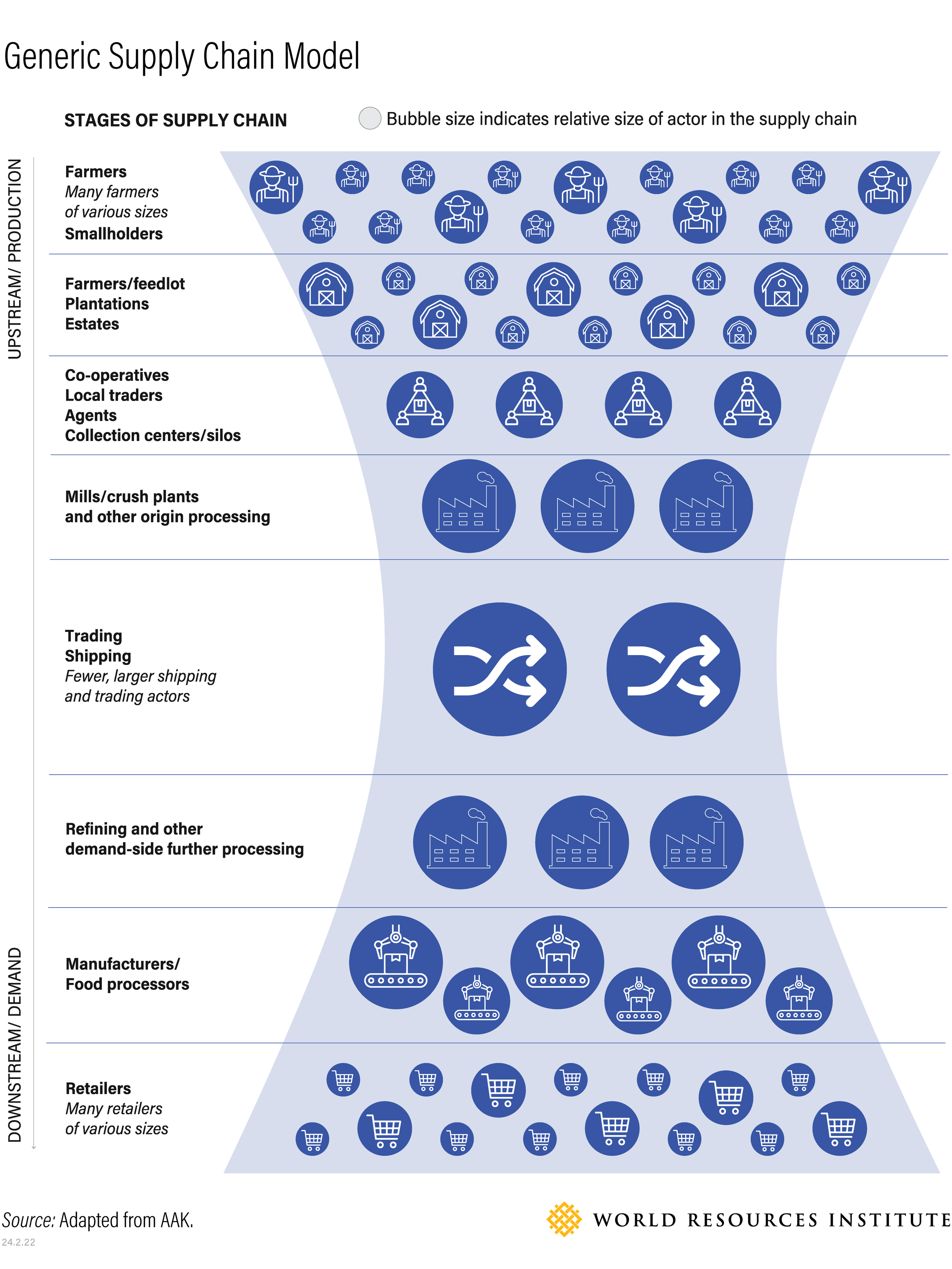
Addressing data challenges for geolocations and traceability will require action in three key areas:
Improving data interoperability and standardization
Currently, there is little coordination and synergy across efforts to collect, manage and distribute geospatial data. The future will most likely see even more divergence in standards and protocols with the growing commercialization of data and proliferation of providers in this space.
The consequences of a lack of interoperability can be far reaching, limiting collaboration between stakeholders along the value chain, raising the costs of traceability and making it harder for companies to meet new regulations and growing transparency requirements.
The absence of data standards also has repercussions on systems and platforms that depend on these data inputs, making them incompatible with one another and limiting the usefulness of data by keeping it locked in siloes.
This is why data standards are a building block of interoperability. Data elements such as geometries, formats and attributes need to be standardized to allow different data sets to be integrated or aggregated.
As part of efforts to address this challenge, FDaP has teamed up with the nonprofit organization Preferred By Nature to develop a preliminary geospatial data sharing protocol, which offers guidance on accurately describing plot extent and location. The protocol provides a systematic set of digital rules for transferring and sharing geospatial points or polygons and other data.
Additionally, open-source solutions and moving towards application programming interfaces (API) would play a significant role in improving interoperability between systems.
Ensuring responsible, trustworthy data sharing
Global supply chains can be complex, involving a multitude of stakeholders and crossing multiple borders. To improve traceability across these supply chains, stakeholders need to be able to share data efficiently and effectively, adopting good practices that take technical, legal and ethical issues into consideration.
Developing best practices and guidelines for data sharing offers a promising avenue to navigate these complexities. A report published by FDaP in collaboration with other partners, Traceability and Transparency in Supply Chains for Agricultural and Forest Commodities, discusses both the complexities and the solutions for data sharing. Despite the challenges, the report shows how data sharing needs to be encouraged and facilitated to reduce duplication of efforts and costs, and to enhance transparency.
There are also legal data restrictions and commercial sensitivities that impede data sharing. Uncertainties linger around permissions for data sharing, including compliance with data privacy laws. Another hurdle is supplier willingness to share sensitive data that can be seen as leading to competitive disadvantages, so ensuring the privacy and security of data along the supply chain is critical.
Overcoming these barriers requires greater coordination with government initiatives aimed at smallholder mapping and registration.
.jpg?sfvrsn=ee457621_1)
Photo by Axel Fassio/CIFOR
Last but not least, there is a lack of robust protocols and best practices to address ethical issues in data sharing. While information about farmers is often the first step of data gathering required for traceability systems, many farmers, particularly smallholders, are not in charge of their own data and are thus unable to reap the benefits of data sharing, raising concerns about data ownership and rights, privacy and security. This makes it critical to ensure farmers give free, prior and informed consent for their data to be collected and shared. Any data sharing process should account for potential unforeseen impacts on farmer livelihoods, land rights and legal prosecution implications.
Solving the geolocation data gap
As a result of the barriers to data sharing, geolocation data for commodities may not be available, accessible or usable.
The good news is that there are already multi-stakeholder collaboration initiatives underway to address these gaps, including efforts to centralize data collection and processing through asset registries, which are comprehensive databases that can play a crucial role in traceability. These registries provide a unified platform for recording information on land parcels, forest reserves and agricultural holdings, for example.
.jpg?sfvrsn=2073d1bd_1)
Photo by Kelly M Lacy
Artificial intelligence is being harnessed in agricultural management for automated field boundary detection, eliminating the time- and cost-intensive process of field verification. Agricultural tech companies are also developing mapping applications, tailored for smallholders, to aid traceability across supply chains.
To help scale these efforts, FDaP is convening stakeholders to ensure more coordination around universal asset registries, making data collection efforts more efficient and enabling the standardization of data.
Forest and Land Monitoring
Accurate and timely forest monitoring is essential to prevent commodity-driven deforestation and to support effective restoration efforts. For regulation compliance, supply chain actors need to harness a variety of global and local data sources and weigh tradeoffs between accuracy, precision, transparency and cost-effectiveness of available data.
Addressing two key challenges will help stakeholders in their monitoring efforts:
Aligning definitions and classification systems
When is a forest a forest? Where does a forest start and end? How do you define and quantify forest degradation? Current data on land cover and land use is produced using definitions that can differ significantly across countries, institutions and communities.
These divergent definitions not only lead to inconsistencies in assessment, but they can complicate the efficient implementation, monitoring and tracking of global progress on deforestation and restoration goals.
There are initiatives that have long sought to address this issue, like the Accountability Framework Initiative (AFi), which aims to establish alignment on key terms and definitions so that companies can use consistent definitions when setting goals, developing policies and procedures, managing supply chains and monitoring and reporting on progress. These definitions, reflecting the consensus of AFi’s broad civil society coalition, are grounded in international norms and best practices.
While the European Union Regulation on Deforestation-free products (EUDR) follows the FAO (the Food and Agriculture Organization of the United Nations) definition of forest, it may not align with those used by available forest cover data products. This is particularly true with national data products, which can be a useful source of information for risk assessment though they tend to use their own national definition of forest.

Photo by Waren Brasse
In addition, there is no standard land cover classification system, though increasingly there is streamlined use of Land Cover Meta Language (LCML) as an internationally recognized standard enabling the consistent creation and description of land cover classes. The LCML provides a common reference structure for the comparison and integration of data for any generic land cover classification system.
It is clear that these challenges need to be tackled collectively rather than in competition. This is why FDaP is convening organizations, governments and private sector partners to enable the development of a consistent geospatial data ecosystem that will allow all stakeholders to access open source, validated data that can be used for the monitoring, verification and disclosure of progress in reducing deforestation and advancing restoration.
Land use mapping
Democratized access to cloud computing and machine learning methods over the past decade has also led to the proliferation of land cover data monitoring products at national, regional or global scales, while land use maps are still rarely found. Yet most regulatory frameworks and tenure registries are based on land use concepts (like forest or agriculture) rather than land cover concepts (like tree cover or short vegetation).
The emergence of high spatio-temporal density imagery and deep learning methods provide an opportunity to shift from land cover to land use mapping, provided that high-quality data is used to train models. FDaP is building data-driven methods to create community commodity maps . The community modelling approach harmonizes training data from various stakeholders and leverages machine learning to produce openly available modes and data products. The first example is the community palm model, available on GitHub, viewable online, and in FDaP’s Google Earth Engine publisher data catalog, accompanied by a publication describing the methodology.
FDaP is also testing the community model approach to create models and data sets for other EUDR-covered commodities, including those grown in complex agroforestry systems such as shaded cocoa or coffee. The iterative approach means these models and data products evolve and improve over time as more data is contributed.
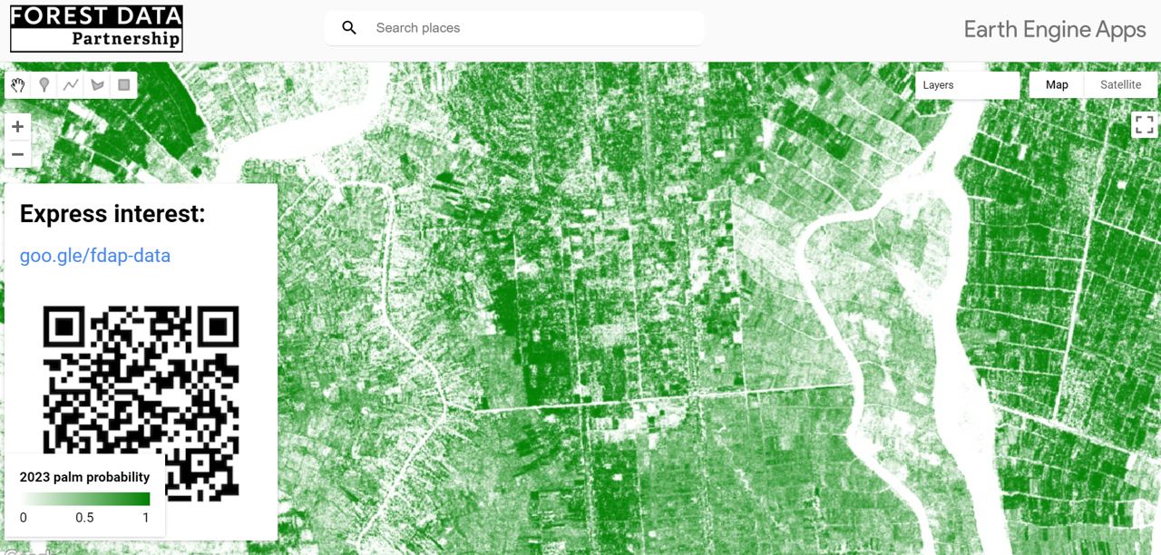
The community palm model, as viewed in FDaP’s Google Earth Engine publisher data catalog
Aligning for a shared data ecosystem
FDaP aims to address the challenges discussed above through a five-step framework of engagement, alignment, innovation, deployment and assessment. Since its initiation in 2021, FDaP has been engaging with relevant stakeholders across different sectors and commodities through webinars and workshops.
Through these stakeholder consultations, FDaP is aligning parties around key data sets in the ever-expanding landscape of forest monitoring data and identifying critical data gaps. Initial focal areas are cocoa in West Africa, palm oil in Southeast Asia and cattle and soy in the Amazon Basin, as well as restoration across these geographies.
This alignment process is important for fostering greater buy-in, trust and collaboration. The process will also engage local stakeholders, such as smallholder farmers and communities, to ensure inclusive representation.
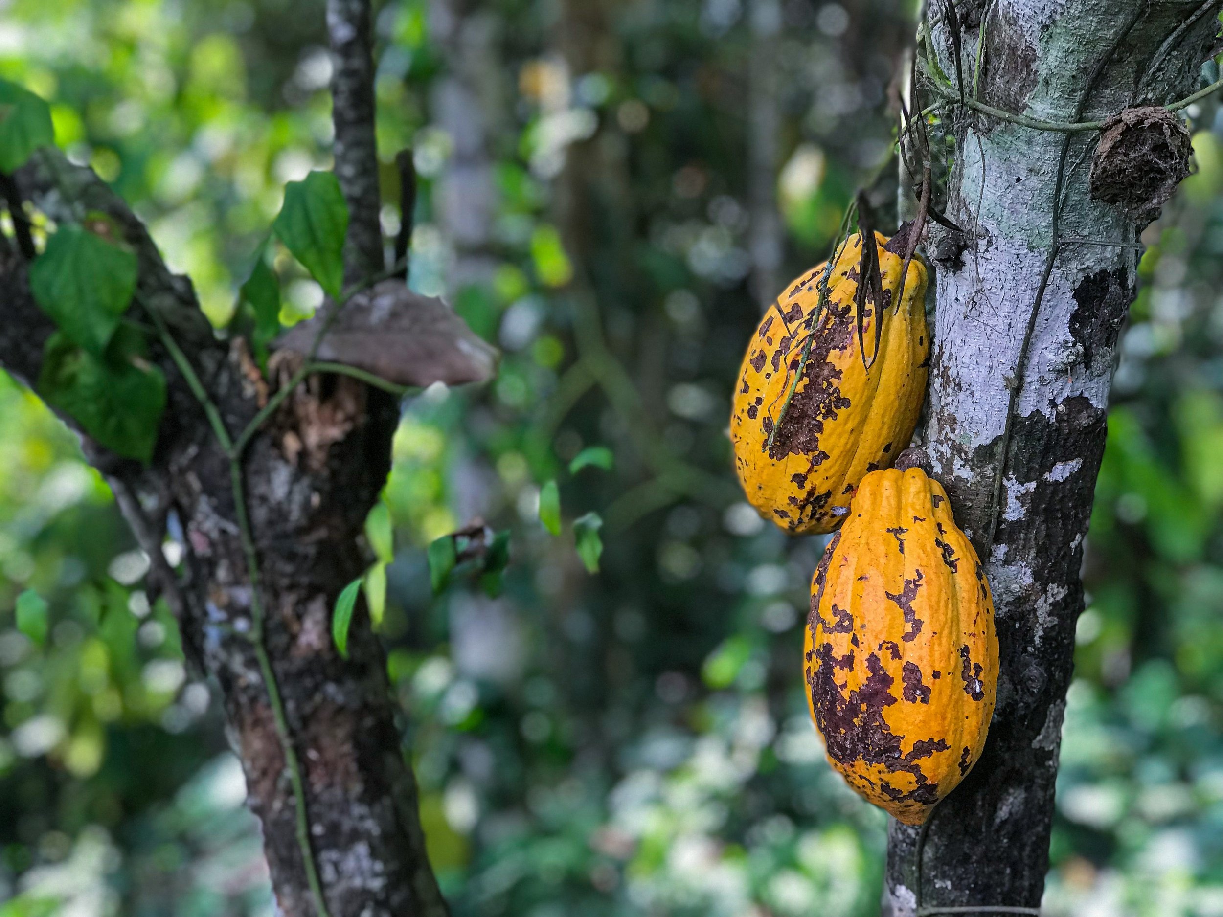
Photo by Kyle Hinkson
While we have discussed potential data solutions that can help to tackle the challenges discussed, it is also important to see these as pieces of a much larger puzzle. Imagine that these pieces (data solutions) are being produced independently of one another so that many of them do not fit together to form a cohesive picture. This lack of interoperability is a critical roadblock to advancing traceability in an efficient manner.
FDaP, together with SAFE (Sustainable Agriculture for Forest Ecosystems) and the Linux Foundation, is working on a digital public infrastructure through the development and deployment of open-source building blocks like geolocation standards, protocols or models.
This story was originally published here.
Related links
Get involved — help improve FDaP’s palm probability model
All supply chain actors are welcome to support FDaP’s mission of collectively improving land use data and helping to shape future solutions.
FDaP’s “Innovate” task force has developed and trained an initial palm probability model . We welcome you to submit data to continuously improve the model and resulting data sets for the public good. This contributed data can take the form of: 1) wall-to-wall layers such as land cover and land use change maps, but also biophysical layers and tenure, or 2) points or polygons containing labelled information of land cover, land use change, tenure, farm and field boundaries.
If you are interested in contributing data, please complete this form or get in touch with us at [email protected]