![]()
![]()
![]()
Jamandre, T.J. and H.R. Rabanal, 1975 Engineering aspects of brackish water aquaculture in the South China Sea Region. SCS/75/WP/16: 37p., 17 annexes
Rajaona, S.G., 1976 Etat actuel de l'aquiculture a Madagascar. In Symposium on Aquaculture in Africa, Accra, Ghana, 30 September-2 October 1975. CIFA Tech. Pap., (4) Suppl. 1: 45–65
Rajaona, S.G., A. Ralison and M. Raveloson, 1975 Plan national de developpement de l'aquiculture a Madagascar. In FAO Aquaculture Planning in Africa, Accra, Ghana, 2–27 July 1976: 66–85
Table 1. Evaluation of suitability of sites visited
| Socio-economic impact (X3) | Water supply system (X1) | Available area (X2) | Water quality (X3) | Soil quality (X3) | Vegetation (X0.5) | Elevation and tidal range (X3) | Mechanization (X1) | Local labour (X0.5) | Protection (wind & flood) (X1) | Power availability (X0.5) | Fry availability (X1) | pH (X1) | Salinity (X0.5) | Weighted total (%) | Remarks | |
| 5 | 5 | 5 | 5 | 6 | 8 | 4 | 5 | 3 | 6 | 3 | 4 | 6 | 6 | 52 | Sites I-IV have average wind velocity of 21 km/hr; salinity of bay water recorded 36–38 ppt; and observed pH 7-10. | |
| 5 | 4 | 6 | 5 | 6 | 8 | 4 | 4 | 3 | 6 | 3 | 4 | 6 | 6 | 52 | ||
| 7 | 9 | 4 | 7 | 6 | 8 | 3 | 6 | 4 | 7 | 5 | 6 | 7 | 8 | 61 | ||
| 7 | 7 | 6 | 6 | 6 | 7 | 2 | 7 | 3 | 6 | 4 | 5 | 7 | 7 | 57 | ||
| 6 | 6 | 4 | 6 | 4 | 6 | 3 | 3 | 3 | 5 | 4 | 3 | 6 | 4 | 48 | Sites A and B have average wind velocity of 14 km/hr; river water salinity 31 ppt; pH of 7-8 | |
| 5 | 4 | 4 | 3 | 4 | 6 | 2 | 3 | 3 | 4 | 3 | 2 | 5 | 5 | 38 |
NOTE: Partly based on Jamandre and Rabanal (1975). Sites with rating of over 50% may be recommended for development; obviously Sites III and IV offer best possibilities for development.
Table 2. Meteorological information - Diego Suarez
| Barometric pressure (mm) | Average temperature | Relative humidity (%) | W I N D | Average evaporation (mm) | |||||
| Average rainfall (mm) | velocity (km/h) | Dominant direction (wind) | Calm (%) | ||||||
| Max. (°C) | Min. (°C) | ||||||||
| Periods | 1957–65 | 1957–65 | 1957–65 | 1931–60 | 1957–65 | 1956–65 | |||
| Months Jan. | 1010.9 | 30.4 | 23.1 | 82 | 276.5 | 14 | W | 18 | 112.8 |
| Feb. | 1010.2 | 30.2 | 22.9 | 84 | 211.4 | 13 | W | 20 | 82.0 |
| Mar. | 1010.7 | 30.3 | 23.0 | 83 | 187.2 | 15 | E | 16 | 107.6 |
| Apr. | 1011.6 | 30.5 | 22.6 | 77 | 55.7 | 19 | ESE | 8 | 164.0 |
| May | 1013.0 | 29.9 | 21.3 | 71 | 8.1 | 21 | ESE | 3 | 227.5 |
| June | 1015.8 | 28.9 | 20.2 | 72 | 8.1 | 23 | ESE | 3 | 222.3 |
| July | 1016.6 | 28.2 | 19.5 | 68 | 6.5 | 25 | ESE | 2 | 241.3 |
| Aug. | 1016.7 | 28.4 | 19.4 | 67 | 7.2 | 27 | ESE | 1 | 274.4 |
| Sept. | 1016.3 | 29.3 | 20.1 | 68 | 4.7 | 28 | ESE | 1 | 302.1 |
| Oct. | 1015.3 | 30.3 | 21.3 | 68 | 10.6 | 29 | ESE | 1 | 311.1 |
| Nov. | 1013.4 | 31.2 | 22.6 | 72 | 27.8 | 24 | ESE | 2 | 225.7 |
| Dec. | 1011.8 | 31.1 | 23.0 | 78 | 111.1 | 16 | E | 12 | 140.7 |
| Annual average | 1013.6 | 29.9 | 21.6 | 74 | 914.9 | 21 | - | 7 | 200.9 |
| (25.75) | |||||||||
Table 3. Meteorological information - Majunga
| Barometric pressure (mm) | Average temperature | Relative humidity (%) | Average rainfall (mm) | WIND | Average evaporation (mm) | ||||
| Velocity (km/h) | Dominant direction | Calm (%) | |||||||
| Max. (°C) | Min. (°C) | ||||||||
| Periods | 1957–65 | 1957–65 | 1957–65 | 1931–60 | 1957–65 | 1951- | |||
| Months January | 1010.6 | 30.8 | 23.7 | 82 | 465.8 | 12 | NW | 7 | 112.4 |
| February | 1009.9 | 30.6 | 23.8 | 84 | 369.7 | 12 | NW | 8 | 78.0 |
| March | 1010.4 | 31.3 | 23.6 | 82 | 282.4 | 12 | E | 7 | 90.1 |
| April | 1011.9 | 32.5 | 22.7 | 74 | 56.8 | 11 | E | 3 | 127.7 |
| May | 1014.4 | 31.7 | 20.1 | 68 | 7.9 | 12 | ESE | 3 | 165.5 |
| June | 1016.6 | 30.6 | 18.5 | 66 | 2.6 | 12 | ESE | 3 | 215.3 |
| July | 1017.7 | 30.4 | 17.8 | 63 | 1.0 | 14 | ESE | 3 | 184.4 |
| August | 1017.5 | 31.2 | 18.2 | 62 | 2.1 | 14 | ESE | 2 | 208.2 |
| September | 1016.5 | 32.1 | 19.6 | 63 | 2.6 | 16 | ESE | 2 | 206.3 |
| October | 1015.1 | 32.4 | 21.6 | 66 | 23.7 | 16 | NW | 4 | 200.9 |
| November | 1013.0 | 32.0 | 23.5 | 72 | 109.6 | 15 | NW | 5 | 158.0 |
| December | 1011.5 | 30.8 | 23.8 | 80 | 242.6 | 12 | NNW | 6 | 116.8 |
| Annual average | 1013.8 | 31.4 | 21.4 | 72 | 1566.8 | 13 | - | 4 | 155.6 |
| (26.4) | |||||||||
Table 4. Data on excavating required in project site
(cut)
I. PONDS
| Pond | Area (m2) | Bottom of ponds (m) | Depth of excavation (m) | Volume (m3) | Total (m3) |
| 1-A | 8 750 | 1.7 | 0.7 | 6 125 | |
| 1-B | 5 000 | 1.8 | 0.6 | 3 000 | |
| 2-A | 3 000 | 1.8 | 0.6 | 1 800 | |
| 2-B | 3 000 | 1.8 | 0.6 | 1 800 | |
| 2-C | 3 000 | 1.8 | 0.6 | 1 800 | |
| 2-D | 3 000 | 1.8 | 0.6 | 1 800 | |
| 2-E | 7 275 | 1.8 | 0.6 | 4 365 | |
| 2-F | 10 000 | 1.8 | 0.6 | 6 000 | |
| 3 | 5 000 | 1.95 | 0.45 | 2 250 | |
| 4 | 20 000 | 1.3 | 1.1 | 22 000 | |
| 5 | 40 000 | 1.7 | 0.7 | 28 000 | 78 940 |
II. CANALS
| Canal | Length (m) | Depth (m) | Bottom (m) | Area (m2) | Volume (m3) | Total (m3) |
| AA' | 400 | 1.8 | 2.5 | 7.74 | 3 096 | |
| BB' | 275 | 1.65 | 1.5 | 5.19 | 1 429.31 | |
| CC' | 200 | 1.2 | 1.0 | 2.64 | 528 | 5 053 |
TOTAL CUT = 83 993.31 m3
Table 5. Data on dike formation in project site (fill)
| Dike | Length (m) | Height (m) | Crown (m) | Area (m2) | Volume (m3) |
| A | 275 | 1.5 | 3.0 | 6.75 | 1 856.25 |
| B | 50 | 2.0 | 3.0 | 10.0 | 500 |
| C-1 | 275 | 2.5 | 3.5 | 15.0 | 4 125 |
| C-2 | 200 | 2.0 | 2.5 | 9.0 | 1 800 |
| D-1 | 97 | 1.5 | 2.0 | 5.25 | 509.25 |
| D-2 | 97 | 2.0 | 3.0 | 10.0 | 970 |
| D-3 | 97 | 1.5 | 2.0 | 5.25 | 509.25 |
| D-4 | 97 | 2.0 | 3.0 | 10.0 | 970 |
| D-5 | 130 | 2.5 | 3.0 | 13.75 | 1 787.5 |
| E | 200 | 3.0 | 4.0 | 21.0 | 4 200 |
| F | 275 | 3.0 | 7.0 | 30 | 8 250 |
| G | 275 | 3.0 | 8.0 | 33 | 9 075 |
| H | 275 | 3.0 | 7.0 | 30 | 8 250 |
| GH-1 | 50 | 4.0 | 5.0 | 36 | 1 800 |
| GH-2 | 50 | 4.0 | 5.0 | 36 | 1 800 |
| GH-3 | 50 | 4.0 | 5.0 | 36 | 1 800 |
| I | 400 | 3.0 | 7.0 | 30 | 12 000 |
| J | 400 | 2.5 | 6.0 | 21.25 | 8 500 |
| K | 400 | 3.0 | 10.0 | 39 | 15 600 |
TOTAL FILL = 84 302.25 m3
| Summary: | Total fill (dikes) | = | 84 302.25 cubic meters | |
| - | ||||
| Total cut (ponds, canals) | = | 83 993.31 cubic meters | ||
| 308.94 cubic meters |
The difference is considered negligible and shall be more than taken up by indentation in the dikes where there are gates.
Table 6. Details of water control gates for project
| Gate number | Designation | Number of openings | Width of openings | Floor top elevation | Length/height* | R e m a r k s |
| G-1 | Primary | 2 | 1.0 m | 0.6; 0.0 | For economy the width of dikes are narrowed and the top elevations lowered. The length and width of the dikes should be adjusted to the narrowed and lowered dikes | 2nd (V = 0.0 elevation) for pump to be operational (sump-submerged) all the time See alternate design given with provision for vertical axial flow propeller pump. |
| G-2 | Gross gate | 6 | 1.0 m | 1.0 | Suggested heights from ground elevation of 2.4 m | 2 facing east 2 facing north 1 facing south 1 facing west |
| G-3 | Secondary | 1 | 1.0 m | 1.1 | 1.5 – 2.0 m | |
| G-4 | 1 | 1.0 m | 1.3 | |||
| G-5 | 1 | 1.0 m | 1.1 | |||
| G-6 | 1 | 1.0 m | 1.2 | |||
| G-3-1 | Tertiary | 1 | 0.75 m | 1.3 | Suggested height is 1.25-1.5 m from ground elevation of 2.4 m | |
| G-3-2 | 1 | 0.75 m | 1.3 | |||
| G-3-3 | 1 | 0.75 m | 1.3 | |||
| G-3-4 | 1 | 0.75 m | 1.3 | |||
| G-3-5 | 1 | 0.75 m | 1.3 | |||
| G-3-6 | 1 | 0.75 m | 1.3 | |||
| G-3-1-1 | Nursery | 1 | 0.50 m | 1.5 | Suggested height is 0.7– 1.5 m from ground elevation of 2.4 m | |
| G-3-1-2 | 1 | 0.50 m | 1.5 | |||
| G-3-4-1 | 1 | 0.50 m | 1.6 | |||
| G-3-4-2 | 1 | 0.50 m | 1.6 | Wooden gates | ||
| G-3-5-1 | 1 | 0.50 m | 1.6 | |||
| G-3-5-2 | 1 | 0.50 m | 1.6 | |||
| GA-1 | Overflow | 1 | 2.0 m | 2.1 | Overflow sides and bottom wooden, protected - bottom protruding over dike side | |
| GA-2 | 1 | 2.0 m | 2.1 | |||
| GA-3 | 1 | 2.0 m | 2.1 | |||
| GA-4 | 1 | 2.0 m | 2.1 | |||
| GA-5 | 1 | 2.0 m | 2.1 |
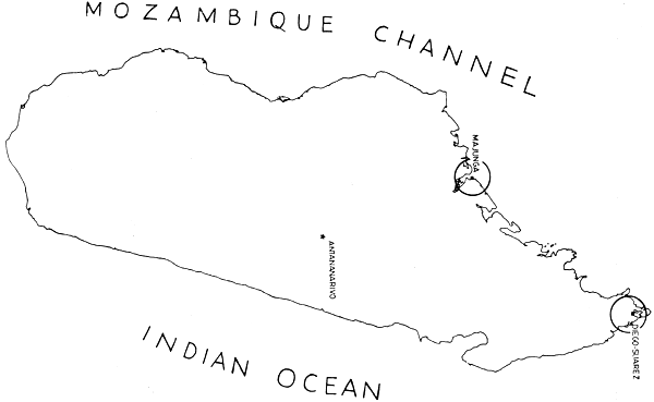
Fig. 1. Map of Madagascar indicating location of Diego Suarez and Majunga
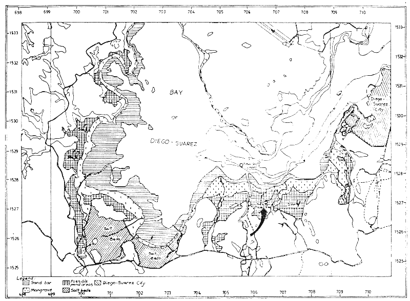
Fig. 2. Project location map of Diego Suarez selected site
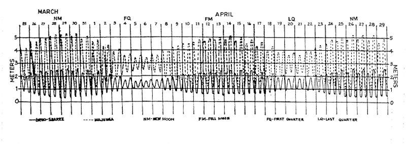
Fig. 3. Graphic presentation of typical tidal cycle, Diego Suarez and Majunga
(March 25 to April 29, 1979)
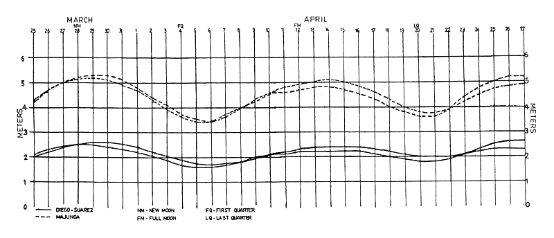
Fig. 4. Typical cycle for high tides in Diego Suarez and Majunga
(March 25 to April 27, 1979)
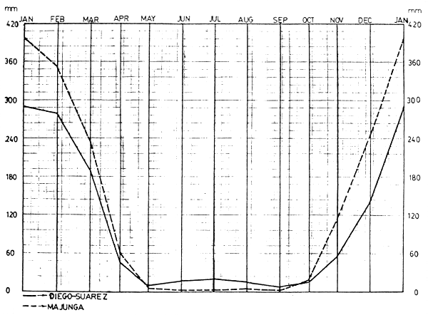
Fig. 5. Mean monthly rainfall for 26 years (1950–76)
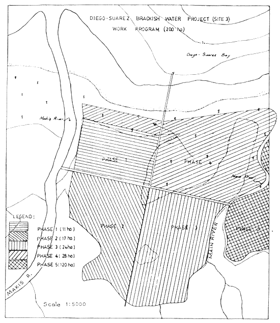
Fig. 6. Diego Suarez brackishwater aquaculture project phase development programme
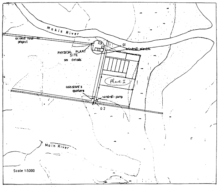
Fig. 7 Diego-Suarez brackishwater aquaculture project general layout
Site III, 11 ha
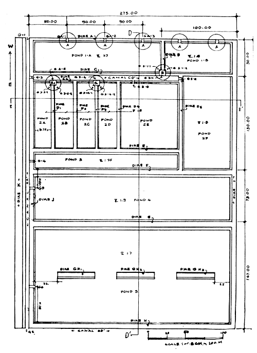
Fig. 8. Detailed layout of Diego Suarez project with key to diagrams
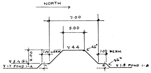
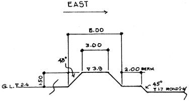 | DIKE A | |
| LENGTH: | 275. M | |
| HEIGHT: | 1.50 M | |
| CROWN: | 3.00 M | |
| BASE: | 6.00 M | |
| SLOPE: | 1:1 (45o L) | |
| VOLUME: | 1856.25 | |
| AREA: | 6.75 | |
CROSSECTIONAL VIEW OF DIKE A
SCALE: .5 CM - 1M
TOP VIEW SHOWING OVERFLOW SECTION
SCALE: .5 CM - 1 M
 |  |
| FRONT VIEW SCALE : .5CM - 1M | DETAIL A noT DRAWN TO SCALE |
| Fig. 9 | Details of overflow section on perimeter dike (Dike A) |  |
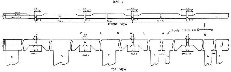
Fig. 10. Details of Dike J
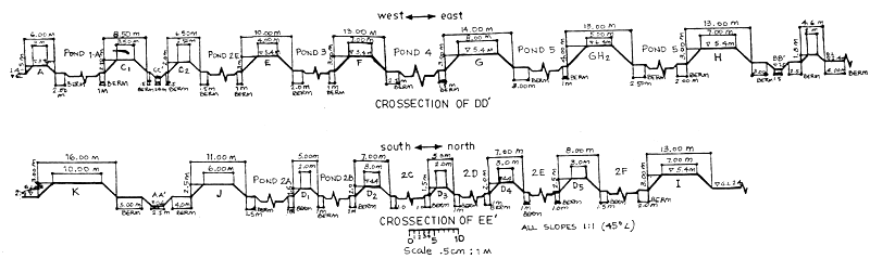
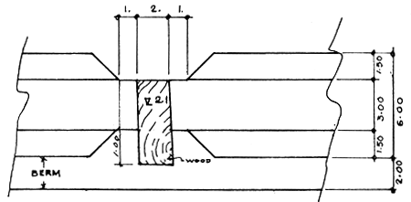
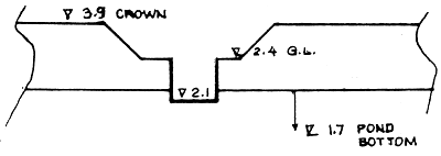
Fig. 11. Cross-sectional details of ponds in Phase I
 | DIKE B | |
| LENGTH: | 50. M | |
| HEIGHT: | 2.00 M | |
| CROWN: | 3.00 M | |
| AREA: | 10.00 M | |
| VOLUME: | 500. M | |
| SLOPE: | 1:1 (45o L) | |
| BASE: | 7.00 M | |
CROSSECTIONAL VIEW OF DIKE B
SCALE : .5 CM - 1. M
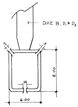
DETAIL B
CAN APPLY FOR B1 & B2
| Fig. 12 Details of Dike B | 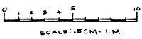 |
NOTE: Length and elevation to be altered to fit new and variable measurements of dikes
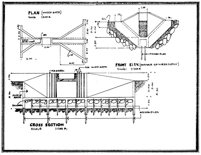
Fig. 13 Details of primary gate, double water passage
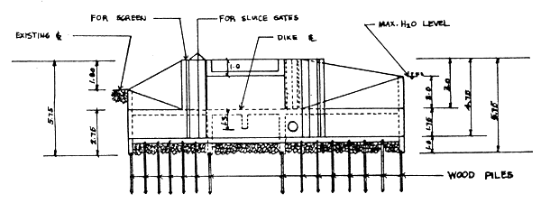
SECTION A-A
Note: length and elevations to be altered to fit new and variable measurements of respective dikes.
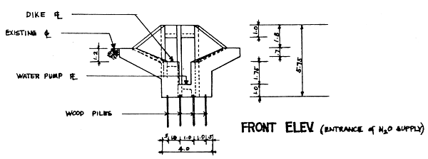
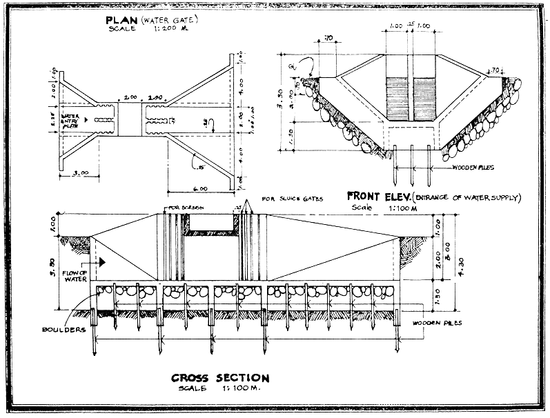
Fig. 14 Alternate primary gate plan, with provision for vertical propeller pump
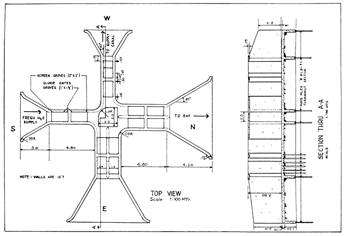
Fig. 15. Details for concrete crossgate
Note: Length and elevations to be altered to fit new and variable measurements of respective dikes.
For G3 to G5
Fig. 16 Details for secondary concrete gate, single water passage
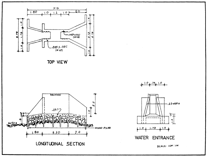
Fig. 17 Details for tertiary concrete gate
 | 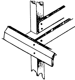 | NOTE: | Length and elevations to be altered to fit new and variable measurements of respective dikes. Opening is .75m for tertiary gates G3-1 to G3-5. Opening is .5m when used for fry ponds G3-1-1 to G3-5-2. |
| PLAN SCALE 1: 100 MT. | DETAIL A | ||
 |  | ||
| END ELEVATION SCALE 1: 100 MT. | |||
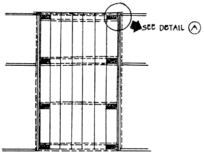
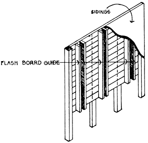
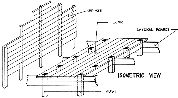
Fig. 18 Tertiary wooden gate-Details A
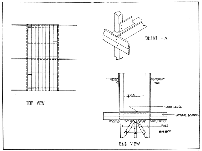
Fig. 19 Tertiary wooden gate-Details B
Note: length and elevations to be altered to fit new and variable measurement of dikes.
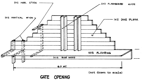
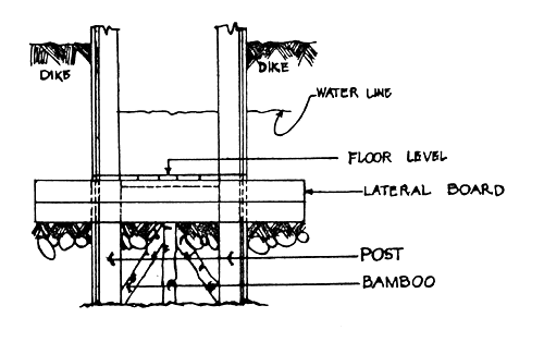
TYPICAL WOODEN GATE
(Usually for Fry Pond)
Fig. 20 Tertiary wooden gate-Details C
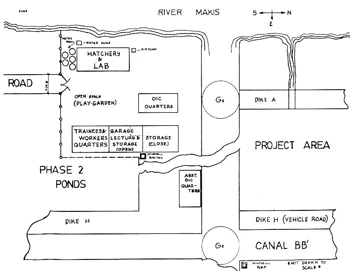
Fig. 21 Project physical site and arrangements
![]()
![]()
![]()