LAND HUSBANDRY ENCOURAGES REGIONAL DIVERSITY IN EROSION CONTROL DEPENDING ON ENVIRONMENTAL, SOCIAL AND ECONOMIC CONDITIONS
Chapter 9. The wide range of erosion control strategies in West Africa: from subequatorial forest to Sudano-Sahelian savannah
Chapter 10. Development of the Bamiléké bocage
Chapter 11. Agroforestry, mineral fertilization and land husbandry in Rwanda
Chapter 12. A new approach to erosion control in Haiti
Chapter 13. Agricultural erosion in the Ecuadorian Andes
Chapter 14. The Mediterranean Montane Region of Algeria
Chapter 15. Pays de Caux: a temperate, field-crop region in north-western France
In Part One of this work the variety of forms that erosion can take in terms of both space (the effect of scale) and time has been emphasized.
It was shown how serious the economic impact of erosion can be for a regional community, especially in terms of downstream damage caused by peak runoff flows, deterioration in the quality of water, and siltation of reservoirs and river beds as suspended load is deposited. Degradation of cultivated land and loss of productivity on soil exposed to erosion vary widely depending on soil type, amount of rainfall and topographical position. An historical review of erosion control strategies shows that for thousands of years humanity has demonstrated a capacity to adapt to changes in environmental and human circumstances in this case, to erosion crises. However, the acceleration of demographic, social and economic change in recent decades has led to a new erosion crisis, with causes that vary from those in large-scale field-crop regions (excessive mechanization, ill-suited to local conditions) to those in semi-arid, extensive agropastoral regions (degradation of plant cover and of organic matter in the soil) or densely populated mountainous regions (increasingly intensive farming with no balanced input of nutrients).
Erosion control is thus not simply a technical problem (and in any case effective techniques are still unavailable in many places), but is in fact primarily a human problem. This has led to proposals for a new approach based on solving immediate needs (increased productivity of both land and labour) while guaranteeing the future through the best management of available water, biomass and nutrients.
In Part Two the five main types of erosion are briefly examined, noting the causes and factors determining the extent of each, and outlining some of the principles of erosion control. (Specific methods have been described in detail in many manuals: CTFT 1969; Hudson 1973; Heusch 1988; Hurni 1986.) Closer concentration was placed on the difficulties of controlling sheet and rill erosion - in other words, the initial forms, which farmers can control on their plots.
The success or failure of such control generally depends on measures taken at the field level, and it is here that peasant farmers' skill is demonstrated in making the best of their physical, social and economic circumstances, developing widely varying techniques for managing water and soil fertility.
Wischmeier and Smith's empirical model has been used to provide a consistent framework for analysis of the causes and contributing factors in sheet (and rill) erosion. The value and limitations of this empirical model have been pointed out: its systematic approach allows definition of the risks of sheet erosion on fields with an average slope (1 to 20%) and a less empirical approach in suggesting a range of methods for reducing average soil loss over a 20-year period to a theoretically acceptable level; it takes no account of exceptional rainfall (typhoons with strong winds, tropical tornadoes with 500 mm of rainfall in one to three days), interactions between different functional sections of a toposequence (water accumulation on the lower part of a slope), steep slopes ( > 20%) where the energy of runoff supersedes that of rainsplash, or, most especially, regional variations in cultural, social and economic conditions affecting the choice of soil conservation methods.
This is the reason why this third part expands the picture of the variety of problems and approaches to conservation to include a wide range of environmental conditions (temperate, semiarid Mediterranean or Sudano-Sahelian climate, subequatorial forest or over-populated mountainous zone, etc.) and human circumstances (developed or developing countries, population pressure varying from 10 to 700 inhabitants per km²). A set of case studies by French-speaking experts working in very different regions is used to demonstrate the ways in which land husbandry can meet present needs for increased land and labour productivity, while improving the rural environment. Since land husbandry is a relatively recent concept, the choice of examples is still limited, and the perspective is not yet broad enough to draw any definitive conclusions from these trials.
Chapter 9 compares the environmental conditions and soil degradation problems along a whole bioclimatic sequence starting from the subequatorial zone of southern Côte d'Ivoire, crossing the Sudano-Sahelian zones of Mali and Burkina Faso, and ending with the Sahelian zone of West Africa.
In Chapter 10, J.M. Fotsing describes the development of the Bamiléké bocage in southwestern Cameroon, where erosion is inversely proportionate to intensification of agriculture.
Chapter 11 reports the present state of research on the integration of agroforestry and subsistence farming among very dense populations (150 to 800 per km²) farming the steep slopes of the Milles Collines region of Rwanda.
Chapter 12 moves to Haiti, describing the implementation of a land husbandry approach based on the people's participation in a whole system of rural development.
In Chapter 13, a Franco-Ecuadorian team analyses the situation of peasant farmers on the volcanic Cordilleras of the Andes, and describes solutions recently developed by these farmers.
Chapter 14 gives the initial results of an INRF-ORSTOM Franco-Algerian team's research, which seeks to define erosion risks and develop intensive farming on the steep slopes of the semiarid Mediterranean mountain regions of northern Algeria.
Lastly, in Chapter 15, J.F. Ouvry, an agricultural scientist working with AREAS, describes the problems involved in the management of surface water in intensive field-crop areas on the temperate plains of northern France.
This aim will have been achieved if at the end of this third part the reader has become aware that it is not enough to apply solutions that have had some (unverified) positive effects in some other part of the world.
No erosion control measures can be envisaged without close analysis of:
• the comparative risks of different kinds of erosion;
• existing traditional methods of managing water and nutrients and restoring soil fertility;
• demographic and/or socio-economic problems, as well as land-tenure and political difficulties linked to the erosion crisis;
• means of increasing production of biomass;
• costs, and the capacity of farmers and/or communities to invest in a land husbandry strategy.
AN EXAMPLE OF AN AGROCLIMATIC SEQUENCE
Eric Roose, Director of Soils Research, ORSTOM, Montpellier, France
Erosion control in the subequatorial forest zone of the Abidjan region of southern Côte d'Ivoire
Erosion control in the humid, tropical, Sudanian savannah of Korhogo in northern Côte d'Ivoire
Erosion control in the tropical savannah environment of the Koutiala region of Mali: strictly rainfed farming
Erosion control in the Sudano-Sahelian savannah of the Ouahigouya region of north-western Burkina Faso: runoff farming
Erosion control in the northern Sahelian zone around the Doti marches in Burkina Faso: valley farming
If a line were drawn from Abidjan to the Sahel a wide range of traditional farming systems would be found along this line.
In the Guinean forest zone of Côte d'Ivoire, there are small mounds on which cassava, maize, groundnut, okra, etc. are multicropped.
In the Sudanian tree savannah of northern Côte d'Ivoire, the Sénoufo shift huge amounts of soil, forming very large mounds (about 80 cm high) to grow tubers (yam, cassava). In following years the fields are ridged with crop residues placed in the furrows and covered with soil from the mounds.
Three hundred kilometres further north, the Miniana in the Koutiala region of Mali reduce tillage to a fairly hasty ploughing following by two surface hoeings.
Another three hundred kilometres further north, the Mossi of the Sudano-Sahelian tree savannah region of Ouahigouya practice direct drill seeding and then flat-hoe.
Lastly, in the sandy zone of northern Yatenga, the Peuhl practice surface sod seeding on untilled ground, and then use hoes to make mounds between the plants in order to concentrate water around the millet planting holes.
This wide range of farming techniques is not the outcome of chance, but of the long adaptation of each group to the environment in which it lives. The longer people have been settled on a given site and the harsher their living conditions, the more they will have developed strategies for managing water, biomass and soil fertility that are suited to their environmental, social and economic situation. It would seem that where farmers have developed very few special techniques, this is often because they have recently migrated from a place with very different problems. For example, in Cameroon the Capsiki, farmers in the Mandara mountains near Mokolo, build bench terraces and low stone walls on steep slopes in an extremely densely populated area. When these people are shifted to the under-populated Sudanian zone of south-eastern Bénoué, beyond Tcholliré, they completely abandon their techniques for water and soil fertility management.
Traditional farming techniques are usually very well adapted to the environmental conditions of the locality - as can be seen by comparing the water balances of the various areas.
These traditional strategies have now been largely abandoned, and are indeed no longer adequate for coping with the problems of soil degradation arising from population pressure: the population is doubling every twenty years in Sahelian savannah and mountain zones. Fortunately, part of this population is migrating into Sudanian zones, thereby relieving pressure on land in the very vulnerable Sahelian zones. Nonetheless, study of traditional strategies provides a good basis for the development of new strategies of water and soil fertility management in order to counteract soil degradation, runoff and erosion, which are all closely linked. The failure of a number of erosion control schemes would quite probably have been avoided if traditional methods had been studied more closely and an erosion control strategy more in tune with local environmental, social and economic conditions had been proposed in place of the generalized imposition of methods developed during the 1930s for mechanized farming in the United States.
The following pages briefly describe ten different situations, with the treatment used for each, depending on the type of land management, general environmental conditions (especially the water balance for each type of crop) and social and economic conditions (especially population pressure) [Plate 10].
Erosion control in the subequatorial forest zone of the Abidjan region of southern Côte d'Ivoire
TRADITIONAL FARMING TECHNIQUES
Following gradual land clearance over five years, Ebrié farmers build small mounds 30 cm high in February, well before the rainy season. These mounds allow them to plant a combination of crops that are complementary in both time and space: on the one hand, cassava cuttings, which take a very long time to cover the ground, and, on the other, very fast-growing crops such as maize, groundnut, okra and tomato, which cover the mounds quickly, are harvested in three or four months, and then leave growing space for the cassava. Mounding has several purposes: apart from drainage and the accumulation of humus so that the tubers grow well, it also organizes drainage and collects fertilizing elements around the crop. And this mixed cropping means that the soil is covered for two years.
A bush or tree crop - coffee, cacao, palm or rubber - is also often introduced under this cover of more or less annual crops. When the soil is exhausted, it is abandoned to fallow or the tree crop, making sure that the under-storey is cut back under the trees. The number of shade trees may be reduced after a short while, but palms and kola trees are retained.
ANALYSIS OF LOCAL CONDITIONS
Such landscapes are composed of convex hills, with typical half-orange forms and convex slopes which may reach 40% at the edges, and flat, sandy, hydromorphic lowlands. Soil on the hills is ferralitic, sandy-clayey, and very resistant to sheet erosion (K = 0.10). This soil is permeable but very acidic and chemically impoverished.
Annual average rainfall is about 2100 mm, spread over ten months; the maximum monthly rainfall is in June, with 700 mm, and annual drainage is 1000 mm. Evapotranspiration is low (1200 mm). Daily rainfall may reach 250 mm once every ten years.
HAZARDS
At the top of gently sloping hills there are two risks:
• soil degradation from the rapid mineralization of organic matter, rainfall impact, and skeletonization of the surface horizon;
• acidification due both to abundant drainage and to leaching of fertilizing elements.
On steep, convex slopes, the previous hazards are combined with that of gullying. And in the valley bottoms the hydromorphic soil is prone to waterlogging in the rainy season and parching in the dry season. As these areas are often peaty and sandy, the soil is very acid, which has to be corrected.
SUGGESTED IMPROVEMENTS (Figure 60)
The neatest solution to the problems of degradation of organic matter and acidification is to cover the soil permanently with tree crops, with a cut-back under-storey grazed by livestock to some extent. On gently sloping uplands root and tuber crops providing less ground cover may be planted (cereals, cassava or various food crops), the aim being to cover the soil in order to minimize surface degradation and slow down runoff.
The second point is to fertilize root and tuber crops with staggered applications of both organic and mineral fertilizer: drainage is so copious during the rainy season that most of the nutrients added to the soil are drained off in June and July, unless the crops are able to take up and store them in their tissues.
The third point is to restore the amount of organic matter in the soil, either by cutting the under-storey, digging in crop residues, or, better, keeping crop residues on the surface and mulching.
It is important to plant early and closely, and to plan both mineral and organic applications which must be staggered in view of the risk of removal by drainage, the poor storage capacity of the soil and the physiological needs of the crops, rather than deficiencies in the soil. Lime is needed if the pH is below 4.8, in order to avoid aluminium toxicity.
On steep slopes, apart from the risks outlined above, it is essential to ensure a permanent cover of pastureland, or, if possible, tree crops with an under-storey of legumes (a mixture of Pueraria and Centrosema). If there is no choice but to grow food crops here, either the whole slope should be mulched, or hedges should be planted and the prunings used to cover the ground with a permanent light mulch.
FIGURE 60 Erosion control in a subequatorial Guinean forest environment, e.g. the Abidjan region
Analysis
Rainfall |
2100 mm/yr |
Max. monthly rainfall = |
700 mm |
Rainfall 1/10 |
250 mm/day |
Monthly PET |
1200 mm/yr |
RUSA |
1200 |
Heavy drainage about |
1000 mm/day |
Ferralitic, permeable,
acid, sandy-clayey soils |
heavy erosion |
||
heavy leaching |
|||
Hazards
Sheet erosion |
||
Rainsplash |
Idem |
|
Skeletonization |
+ |
Siltation |
Leaching |
Gullying |
Waterlogging |
Acidification |
Scouring |
Acidification |
Improvements
Convex uplands
- Cover the soil: plant early + thickly + mixed cropping
- Fertilization adjusted to meet crop needs
- Management of organic matter; cover plants/mulch
- Supplementary organic and mineral fertilization in staggered doses
Steep slopes
- Permanent soil cover, under-storey of legumes. Palms, rubber, coffee, cacao
- If root and tuber crops are unavoidable, hedges + light mulch + staggered fertilization
Valleys
- Surface drainage
- Interception of lateral inputs
- Dry-season irrigation
- Management of organic matter + staggered mineral supplements
- Bananas + horticulture
In the valleys, the problem is that of organizing drainage of excess water during the rainy season, digging lateral channels to catch water from slopes, and providing irrigation during the dry season, especially for banana plantations and horticulture. Staggered applications of organic matter, lime and mineral nutrients must be planned, taking account of the risk of their removal by drainage.
Erosion control in the humid, tropical, Sudanian savannah of Korhogo in northern Côte d'Ivoire
TRADITIONAL FARMING TECHNIQUES
After selective, gradual clearing by burning over several years, the Sénoufo build large mounds as high as 60 to 80 cm to grow yam or cassava.
During the second, third and fourth years, the farmers place weeds, crop residues and assorted biomass elements between the mounds, covering them with earth, taking half a mound from either side. This forms new large ridges on which they intercrop maize, sorghum and groundnut with various secondary crops such as tomato, tobacco and okra.
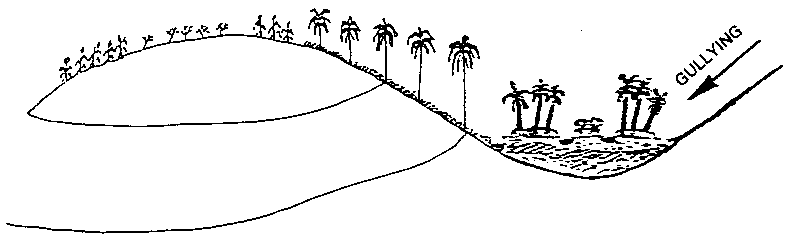
The fields form a patchwork of small ridged plots with tied edges. When rainfall is excessive, the water runs into a drainage ditch, which unfortunately often turns into a gully. The direction of the ridges is seen as irrelevant, varying from one field to another.
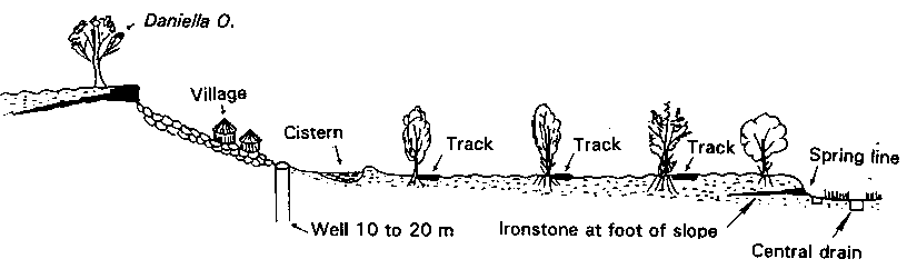
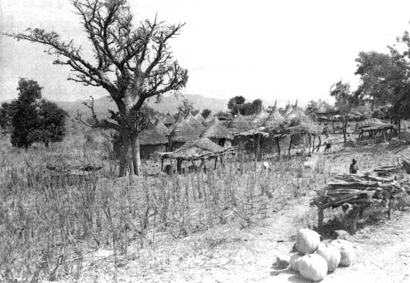
The Sénoufo have a long tradition of agroforestry, and when they are clearing land, they retain a whole series of trees of recognized value: locust bean, karité, kapok, baobab, Daniela olivieri and many others. As the years pass, they protect the stumps of these trees while cutting them back to allow food crops to be grown.
In the hydromorphic valley bottoms, the Sénoufo grow irrigated rice, digging a feeder channel down the side of the valley, with side offtakes for excess water, and central drainage capable of carrying off large amounts of water during the wettest months.
ANALYSIS OF LOCAL CONDITIONS
Average annual rainfall ranges from 1000 to 1400 mm. The heaviest monthly rainfall can reach 400 mm for an annual volume of drainage of 400-200 mm. The aggressiveness factor is very high at 700 to 500 - and at ten-yearly intervals rainfall in a single day can reach 140 mm. Risks of leaching and erosion are therefore considerable, although reduced by a luxuriant vegetation.
The landscape is composed of lateritic tabular hills or granite domes surrounded by scree slopes of large rocks and long sloping pediments of red or ochre ferralitic soil, with gradients decreasing from 5 to 1% . The soil in the valley bottoms is hydromorphic, sandy and humus-bearing. Traditionally this low-lying land was used as a reserve supply of green forage for livestock during the dry season, but in the past 50 years a large proportion has been given over to irrigated rice, increasing the danger of overgrazing on the slopes. The soil on the hills is ferralitic, very desaturated, often gravelly, and resistant to erosion, but acid and chemically very impoverished. Although the whole profile is ferralitic in type, the top horizons are at present in the process of changing into more ferruginous tropical soils. Toward the foot of the slope is a spring line, and below this is the grayish, hydromorphic and generally sandy-clayey soil used for rice growing.
FIGURE 61 Diagram showing improved use of a granitic landscape in Sénoufo country (Korhogo): example of farming requiring drainage in a Sudanian zone
Ironstone plateau |
Scree slopes with large boulders |
Gravelly pediment |
Sandy-loam pediment on red(r)ochre(r)grey hardpan |
Bottom lands subject to prolonged
runoff |
Extensive rangeland + crops on
large mounds |
Reserve of fragile land |
Intensive cropping block with
reserve of stumps of useful trees |
Rice fields + fruit and banana
gardens |
|
slope < 0.5% |
< 20% |
8 to 3% |
3 to 1% |
1 to 0.1% |
Ridging on gentle slope leading to
spillways |
||||
Rows of trees ± hedges |
Ferralitic
soils
very poor in organic matter and bases, deficient in N and P
highly desaturated due to strong drainage, and risk of waterlogging for two months often gravelly, drying out fast
Hazards
- Degradation of organic matter:
acidification of plateau land |
- Temporary waterlogging: rotting
of tubers |
- Flooding in August + September |
- Gullying at foot of hills and
starting at villages + tracks |
- Sheet erosion(r)rills(r)gullies |
- Silting up with material carried
down in gullies |
- Leaching of nutrients.
acidification |
Improvements
- Organic and mineral
fertilization of deep upland soil |
- Blocks of mixed crops on ridges |
- Central drainage: lateral
irrigation of rice fields + fodder in the dry season |
- Reforesting the remainder,
rangeland (cashew, teak, eucalyptus) |
- Gently sloping large ridges,
tied or untied, with rainfed rice in the furrows |
- Off-season fruit trees bordering
household plots |
- Downstream: villages + wells |
- Drainage on the edges by grassed
spillways, used as tracks in dry season |
|
- Cisterns on drainage lines to
irrigate small fruit gardens |
- Agroforestry: hedges and rows of
trees every 25 to 50 m to form gradual banks |
|
- Fenced livestock paddocks with
hedges |
HAZARDS
The soil on the hills has a good structure and good drainage. It is exposed to risks of acidification through use of fertilizers, degradation of organic matter (like all tropical soils, and leaching caused by extensive internal drainage. If this soil is mechanically tilled it gradually loses most of its organic matter and its resistance to the impact of rainsplash, becoming prone to erosion and runoff. On steep slopes, in heavily populated areas with overgrazing and late fires, gullies tend to develop on the lower part of slopes. On the central cropped pediment, apart from the dangers of soil degradation, acidification and leaching, sheet erosion can turn into gullying. Moreover, the runoff from the hills can also waterlog the surface soil and rot tubers.
SUGGESTED IMPROVEMENTS (Figure 61)
In the ironstone uplands, scree slopes and broad gravel pediments, forestry potential can be improved by planting cashew, teak and forage trees.
Small fruit gardens, irrigated from wells, can be planted around dwellings, which are very numerous in this region. Indeed, below the gravelly layer there are alterites which stay moist almost to capacity on the fields throughout the better part of the year. Cisterns could be dug at the foot of this zone to lighten the task of drawing water for livestock and village use (permanent water tables lie at a depth of between 10 and 30 m).
So far as the cultivated section is concerned, it is best to keep small ridged fields on gentle slopes, tying them to some extent, and possibly sowing rainfed rice in the furrows. Grass strips with trees (which will act as green stakes) or hedges should be planted around fields to keep out wandering livestock. Spillways also have to be built to carry off excess water during the wettest months, and to act as grassed pathways for removal of produce during the drier months.
Rice fields can be laid out in the valley bottoms with two side channels collecting water flowing from the spring lines and river water upstream. The centre of the valley is the central drain through which the river flows, and this will carry off excess water. Fruit and vegetable gardens can be created on the edges of the valley, not far from the spring lines. Lastly, it would be wise to plan a dry-season fodder crop on the rice fields and in the wetter parts of the valley, planting hedges in order to control livestock more effectively.