Any part of this set of computer programs and the corresponding data sets may be modified in the light of new knowledge or new objectives. The model is part of a larger district- and national-level planning tool and is expected to be expanded and refined with use.
The designations employed and the presentation of materiel in this publication do not imply the expression of any opinion whatsoever on the part of the Food and Agriculture Organization of the United Nations or IIASA concerning the legal status of any country, territory, city or area or of its authorities, or concerning the delimitation of its frontiers or boundaries
M-59
ISBN 92-5-103545-8
All rights reserved. No part of this publication may be reproduced, stored in a retrieval system, or transmitted in any form or by any means, electronic, mechanical, photocopying or otherwise, without the prior permission of the copyright owner. Applications for such pemmission, with a statement of the purpose and extent of the reproduction, should be addressed to the Director, Publications Division, Food and Agriculture Organization of the United Nations, Viale delle Terme di Caracalla, 00100 Rome, Italy.
(c) FAO 1994
The potential for sustainable food production, including meat and milk, is determined by physical factors, primarily by soil and climatic conditions, and a complex interaction of socioeconomic, cultural and technological factors, such as farm sizes, level of farming and livestock inputs, management practices including soil conservation and enhancement, veterinary services, economic factors like market prices and access, credit availability, education and extension services. At any given point in time, there are limits to the sustainable levels of food crop and livestock feed production obtainable from any given land area, and hence limits to the human and livestock population that can be supported from any area.
Development of land resources to meet food needs of growing populations should be based on integral assessment and consideration of ecological, social and economic factors. Development policies in the past, while focusing on economic and social considerations, have largely ignored the ecological issues. Recognizing the critical importance of resource literacy, the Food and Agriculture Organization of the United Nations (FAO), with the collaboration of the International Institute for Applied Systems Analysis (IIASA), developed a land resources data base and a methodological framework to assess food production and population supporting potentials in developing countries, FAO (1971-81, 1976a, 1978-80).
FAO has assisted member countries in finding rational solutions to various problems of land resources appraisal for planning sustainable agricultural development. This involves linking land use options with other development goals in such areas as food production, food self-sufficiency, cash crop requirements, population supporting capacity, issues of soil fertility constraints, soil erosion risks and land degradation. The AEZ approach was first applied in a global study of Land Resources for Populations of the Future (FAO/UNFPA/IIASA, 1983), which focused on the determination of ecological potential of land resources for food production and the appropriate policies for their management. Subsequently, the AEZ methodology has been extended, refined and utilized in national and sub-national assessments of land productivity and population supporting capacity in various countries, such as Bangladesh, China, Mozambique, Nigeria, the Philippines, Thailand. To further enhance the AEZ methodology for national and sub-national applications, FAO, with the concurrence of the Kenyan Government and IIASA's participation, undertook an AEZ case study of Kenya. The Kenya study (FAO/IIASA, 1991) features various advances in AEZ procedures; these include the linkage to Geographic Information Systems (GIS), methodological refinements and development of a resources database. The enhancements encompass representation of multiple cropping systems, livestock and crop sector integration, assessment of fuelwood productivity, optimization of land use. A major GlS-oriented Kenya land resources database at the scale of 1:1 million and a PC and UNIX workstation based software system were developed in the case study. This analysis tool facilitates the integration of ecological, technological, social, demographic and economic recommendations for the appraisal of land resources of individual districts in Kenya for policy formulation and development planning.
The methodology to assess the food crop and livestock production potential includes the following principles which are, fundamental to any sound evaluation of land resources:
Accordingly the application of the methodology in this work entitled "Agro-ecological Land Resources Assessment for Agricultural Development Planning: A Case Study of Kenya" is concerned with the determination of land use potentials of land resources in each of the 41 districts in Kenya, and the preparation of scenarios for optimal district land resources allocation as a tool in policy formulation and development planning. The Kenya case study is presented in two main reports supported by technical annexes which deal with details.
The first main report describes the computerized land resources database of Kenya and the crop, livestock and fuelwood productivity models developed for the estimation of potential productivity of land resources. It is supported by the following technical annexes:
This is the second main report on "Making Land Use Choices for District Planning". It describes how the results of the crop productivity assessment at district level are used in combination with technological, social, demographic and economic opportunities and constraints to formulate and analyse various scenarios of optimal land use to achieve specific objectives. It is supported by a User Manual, which is a guide to installing and running the PC version of the Kenya software. A demonstration version of the software package on diskettes is part of the User Manual. This report enables the reader to explore the Kenya-AEZ system in its various components, using the computer as an analysis tool as well as a learning tool. If a suitable computer is available, the reader is advised first to install the software and become acquainted with the menu options, and secondly make computer runs while studying the report.
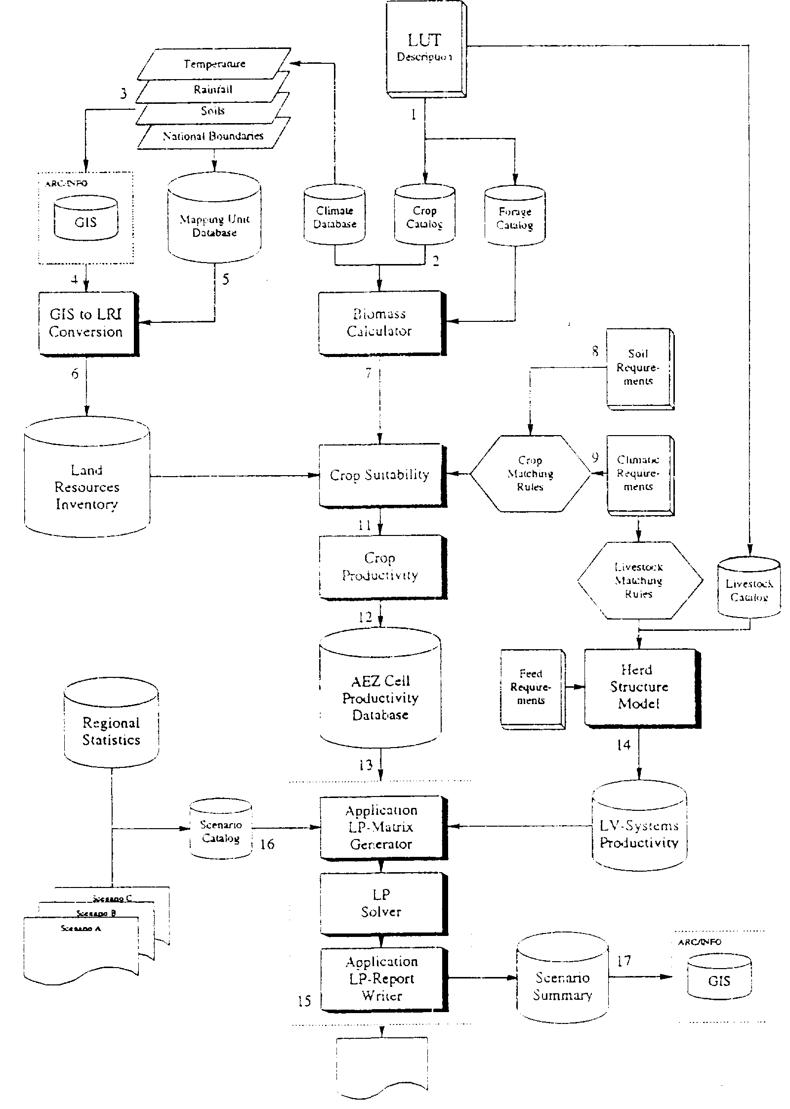
Figure 1.1 gives a general overview of the flow and integration of information as implemented in the Kenya study. In the following explanations, which summarize the contents of the elements of the system, the numbers in brackets relate to the numbering used in Figure 1.1.
(1) LUT description: To define the fundamental objects of analysis which comprise the set of alternative activities available to reach specified objectives, the first step in an AEZ application is the selection and description of land utilization types (LUT) to be considered in the study. FAO (FAO, 1984) defines LUT as follows: 'A Land Utilization Type consists of a set of technical specifications within a socio-economic setting. As a minimum requirement, both the nature of the produce and the setting must be specified'. The description can best be prepared in a hierarchical structure that defines, for example:
FIGURE 1 AEZ application: information flow and integration
The number of aspects that can be meaningfully included in the description as well as the amount and detail of quantitative information provided must match the needs and scale of the study. The Kenya study distinguishes 64 crop LUTs, 31 fuelwood LUTs and a synthetic grassland LUT, each at three levels of input. Similarly, 10 representative livestock systems are considered per input level.
(2) The term 'Crop catalog' refers to a
computer representation of the quantitative aspects of the LUT
description in a database format. The level of detail regarding
the representation of different crop species and varieties in the
database should match the study objectives as well as the
sophistication of other methodological components and the scale
at which the study operates.
(3) The assessment of alternative land utilization types is
performed for a set of land units, i.e. areas of land with
specified and distinguished characteristics. Ideally, the defined
land units should represent unique and homogenous land management
units. In practice, land units are often arrived at by
super-imposing various thematic maps regarding aspects such as
climate, soils, landform, slope, vegetation, present land use,
social and economic characteristics, and administrative
boundaries.
(4) To facilitate the storage and manipulation of complex spatial
information, the maps are best entered into a computerized
geographical information system (GIS).
(5) Additional data related to the mapped information, e.g. a
description of the soil mapping units in terms of soil
associations, soil phases and texture classes, landform, slope,
etc., is kept in the computerized system in the form of attribute
database files.
(6) Combining overlaid spatial information with the contents of
relevant attribute files results in the creation of unique (in
terms of a set of selected attributes such as thermal regime,
moisture regime, soil type, slope class, etc.) geo-referenced
extents of land units, termed agroecological cells, which form
the basic unit of analysis used in AEZ applications. The
collection of agro-ecological cells constitutes the land
resources inventory (LRI). The detailed land resources inventory
used in the Kenya study distinguishes some 90000 agro-ecological
cells.
(7) The methodology used in larger scale regional or national AEZ
applications for determination of agronomically attainable yields
in an agro-ecological cell starts out from estimation of maximum
agro-climatic yield potential as dictated by climatic conditions.
Biomass accumulation is described in terms of photosynthetic
characteristics and phenological requirements, to calculate a
site specific constraint-free maximum yield. Then agro-climatic
constraints are assessed to derive agronomically attainable
yields taking into account yield losses occurring due to
temperature limitations, moisture stress, pests and diseases, and
workability. Attainable yields are estimated for different levels
of management and inputs.
(8) Crops, grasses and fuelwood species, as well as livestock
species have climatic requirements which must be known for
suitability assessment. These include, for instance, temperature
limitations for cultivation, tolerance to drought or frost,
optimal and marginal temperature ranges for cultivation, and, for
some crops, specific requirements at different phonological
stages.
(9) To assess the suitability of soils for particular land
utilization types, soil requirements of crops must be known. In
addition, these requirements must be understood within the
context of limitations imposed by landform and other features
which, perhaps, do not form a part of soil but may have a
significant influence on the use that can be made of the soil.
Distinction is made between internal soil requirements of crops,
such as soil temperature regime, soil moisture regime, soil
fertility, effective soil depth for root development and chemical
soil properties, and external requirements related to soil slope,
occurrence of flooding and soil accessibility.
(10) Matching rules for comparing requirements of crops and
livestock to the attributes of a particular agro-ecological cell
are devised by experts and stored in a database.
(11) As a result of the agro-climatic and agro-edaphic matching
procedures, each agro-ecological cell is rated in terms of
several suitability classes with respect to all land utilization
types relevant in that location.
(12) On the basis of crop suitability, the productivity
assessment tries to capture important factors that impact upon
the production levels that can be attained on an annual basis:
production increases due to multiple cropping resulting from
intensification of cultivation in space and time are taken into
account in the analysis, as are possible productivity losses due
to soil erosion. Since the productivity estimates relate to
production on a sustainable basis, fallow requirements, to
maintain soil fertility and structure and to counteract soil
degradation caused by crop cultivation, are imposed depending on
climatic conditions, soil type and level of inputs and
management.
(13) The productivity assessment records input level specific
production of relevant and agro-ecologically feasible cropping
activities; the stored information includes amounts of main
produce and by-products, input requirements and associated soil
erosion. The algorithms applied impose a filter that eliminates
activities that are ecologically unsuitable in the
agro-ecological cell under consideration, too risky with respect
to climatic uncertainties, environmentally unacceptable, or much
inferior to other possible activities in this land unit in terms
of both expected economic benefit and nutritional value. At this
stage of the analysis a database is created that contains for
each agro-ecological cell quantified information on all feasible
land utilization types. This database lends itself to tabulating
or mapping potential arable land by crop or zone; but more
important, the database provides the necessary geo-referenced
agronomic data for district or national planning scenarios.
(14) The performance of livestock systems is estimated by
describing a representative herd composition, by age and sex,
fertility rates and mortality, and quantifying pro duction of
meat, milk and other outputs in relation to different management
levels and feed quality. Input to output relationships of
livestock systems, expressed per reference livestock unit, as
implied by feed requirements and resulting production of the
total herd is recorded in a livestock systems productivity
database for use in the planning model.
(15)Planning scenarios in the AEZ application are specified by
selecting and quantifying objectives and various constraints
related to aspects such as demand preferences, production
targets, nutritional requirements, input constraints, cash flow
constraints, feed balances, crop-mix constraints, and tolerable
environmental impacts. Given the potentially large number of
agro-ecological cells and number of activities to be taken into
consideration, the objective function and the constraint set have
been defined by means of linear relationships to allow for
application of standard linear programming techniques.
(16) Different sets of assumptions, e.g. regarding population
growth, availability and level of inputs, consumer demand, etc.,
are stored in the scenario catalog, a database used by the
application programs.
(17) Output from the AEZ application report writer is kept in a
scenario summary data base and can be linked to the geographical
information system for visualization of the results.
Several of the steps sketched above will be illustrated and further explained in the following chapters. However, it is recommended to install the software system for hands-on practicing, as described in the User Manual.
The User Manual and software described in this Report are available from FAO Distribution and Sales Section, Viale delle Terme di Caracalla, 00100 Rome, Italy. Fax No. 396-52253152 or 5155. Email: Publications/[email protected].