Back to contents - Previous file - Next file
The third option of the main menu (SF3) is used to generate tables of expected primary yield by crop type for all admissible combinations of pattern codes and length of growing period zone codes. Individual LGP-pattern component yields are added up using pattern distribution probability weights to arrive at expected average annual yields (under single cropping). In addition to average yields, expected output under best and worst climatic conditions is calculated. At this stage, the assessment does not yet consider edaphic constraints.
The yield generating module consists of a four-fold nested loop: over two broad soil unit types (Fluvisols and other soils), a range of LGP-pattern codes, and a range of length of growing period codes. The inner-most loop runs over a range of crop codes. Growth cycle requirements are tested against the number of days available for plant growth. Expected yield by individual LGP-pattern and by component LGP is computed and weighted by the probability of occurrence of each pattern; this results in average yields for given climatic conditions. Minimum, maximum and average yields are stored for use in crop suitability (SF4) and land productivity assessment (SF5). To generate yield tables for the currently selected level of inputs (low, intermediate or high), proceed as follows:
Step 1: In the main menu of KENYA-AEZ, position the cursor on the first option shown (SF1), DATABASE, and press <ENTER>.
Step 2: In the sub-menu on display, select option three (SF3), PREPARE DATA, and press <ENTER> .
Step 3: Return to the main menu of KENYA-AEZ, position the cursor on the third option (SF3), ATTAINABLE YIELDS, and press <ENTER> .
Step 4: In the sub-menu appearing on the screen, select the first option (SF1), GENERATE TABLE, and press < ENTER > .
Step 4 will load the yield generating module and run it to evaluate yields for all possible combinations of LGP-pattern and component LGP.
Example 2.2: Calculating maize yields. In the LRI about 35 percent of Kenya is shown as belonging to LGP-pattern zone 13, LGP-pattern symbol 2-1. According to the pattern proportion table, these areas have two distinct growing seasons in 70 percent of the years, and one growing season in the remaining 30 percent. Over 80 percent of the land in LGP-pattern zone 13 has a mean total dominant LGP of less than 120 days. A small fraction of the area is indicated as having a mean total LGP of 210-239 days (LGP code 9). Let us consider, for instance, maize yields in that zone. According to the LGP-pattern rule table, LGP code 9 in LGP-pattern zone 13 has the following characteristics:
TABLE 2.2
Example of attainable maize yields at intermediate input level
| Crop | Growth cycle (days) |
Maximum yield (kg/ha) |
Thermal zone |
LGP21 120-149 (kg/ha) |
LGP22 60-89 (kg/ha) |
LGP11 180-209 (kg/ha) |
Average yield (kg/ha) |
| Maize 1 | 70-90 | 2370 | T1,T2,T3 | 360 | 1860 | 2540 | 2064 |
| Maize 2 | 90-110 | 3510 | T1,T2,T3 | 0 | 2530 | 3450 | 2806 |
| Maize 3 | 110-130 | 4450 | T1,T2,T3 | 0 | 3200 | 4350 | 3545 |
| Maize 4 | 120-140 | 5320 | T4 | 140 | 3500 | 4880 | 3914 |
| Maize 5 | 140-180 | 5840 | T4 | 0 | 0 | 5200 | |
| Maize 6 | 180-200 | 6440 | T4 | 0 | 0 | 4120 | 0 |
| Maize 7 | 200-220 | 6820 | T5 | 0 | 0 | 4560 | 0 |
| Maize 8 | 220-280 | 4490 | T5 | 0 | 0 | 2500 | 0 |
| Maize 9 | 280-300 | 4500 | T5,T6 | . | 0 | 490 | 0 |
(a) 2 growing periods in 70 percent of years, with a longer component growing period, LGP21, of 120-149 days (component LGP code 6), and a shorter component growing period, LGP22, of 60-89 days (component LGP code 4).
(b) 1 component growing period in 30 percent of years, LGP11, of 180-209 days (component LGP code 8).
In the yield generating module, both these situations are evaluated and average yields are derived. Table 2.2 sumniarizes the relevant information on maize yields in LGP-pattern zone 13 (dominantly bimodal), mean dominant LGP zone 9 (210-239 days), at intermediate level of inputs. Crop types are considered viable only if the growth cycle fits entirely within the longest growing period (long rains) of the dominant pattern component. In this example, the dominant pattern component is bimodal (70 percent of years), the longest component LGP is LGP21 with 120-149 days. Table 2.2 shows that in low-land areas (thermal zone T1-T3, i.e., at an altitude < 1550 metres), Maize 3 performs best; in thermal zone T4 (15501950 meters altitude) only the shortest high-land maize types, Maize 4 with 120-140 days growth cycle, could be cultivated. Figure 2.2 shows agronomically attainable yields of lowland maize types according to length of component growing period, at intermediate level of inputs.
LAND PRODUCTIVITY ASSESSMENT - AN EXAMPLE
The fifth option (SF5) PRODUCTIVITY ASSESSMENT processes the records of the land inventory and computes for each location the production potential by single crop as well as crop combinations according to the following rules:
FIGURE 2.2 Attainable lowland maize yields at intermediate input level
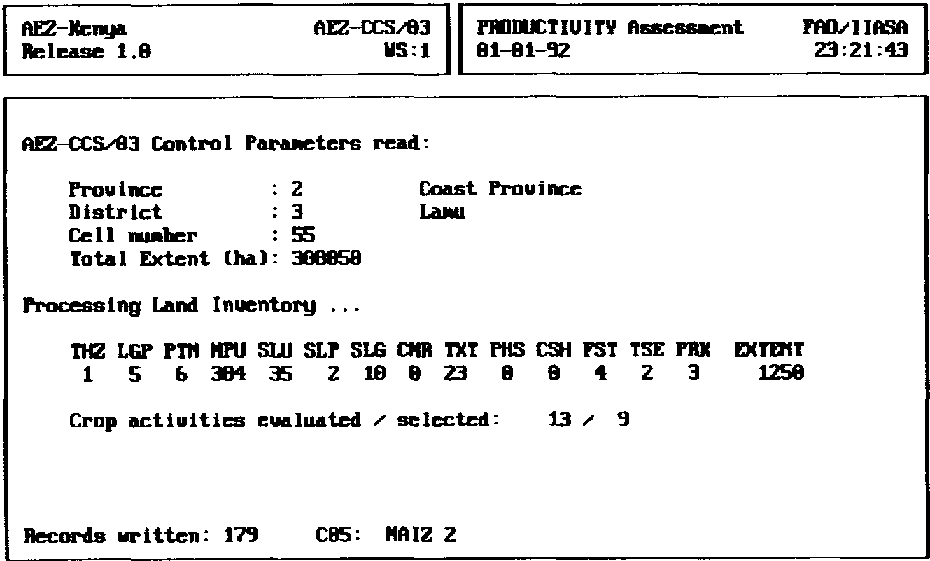
FIGURE 2.3 Screen display, program AEZCCSO3
(1) Crop growth cycle suitability
(2) Thermal zone rating
(3) Soil unit rating
(4) Slope gradient cultivation factor|
(5a) Coarse material rating
(5b) Texture rule
(6) Phase rule
(7) Fallow land requirements rule
(8) LGP-pattern distribution
Application of these rules yields a productivity factor relating average yield to the maximum attainable yield of a particular crop. In each location every admissible crop combination is also evaluated in terms of implied soil loss from erosion (only water erosion is considered).
A record from the land inventory file is read and primary production for each crop is calculated under the specific agro-climatic conditions. Crop productivity assessment takes into account water stress, agro-edaphic requirements, inter-cropping increment multipliers, and rest period requirement factors. If at least one feasible crop, i.e., a crop that is sufficiently productive in the given environment, is identified in the current cell, then relevant cell information is saved and evaluation continues.
As a next step, multipliers of the USLE (Universal Soil Loss Equation), for which evaluation is independent of the actual land-use (i.e., crop combination), are calculated: the rain erosivity factor, the rain erosivity distribution during the growing period, the soil credibility multiplier, the slope length factor, and the protection factor, as relevant under the given agro-ecological conditions and the chosen input level.
A major task in the KENYA-AEZ land productivity assessment is the construction of meaningful sequential crop combinations. Amongst all combinatorically possible combinations, the admissible cropping patterns are filtered out evaluated and, subject to certain performance criteria, saved for later processing.
The crop combinations are also assessed in terms of soil erosion hazards. A crop combination specific multiplier in the USLE is calculated, i.e., a combined crop cover and management subfactor, derived by matching the members of a sequential crop combination to the component LGPs of the current LGP-pattern and mean total LGP codes. Estimated annual soil loss is then translated into estimated productivity loss.
At this point, the program has completed data processing for the current cell and proceeds reading the next land inventory record. The described computations continue until the end of the land inventory file (EOF) is reached, i.e. the last cell has been processed.
The screen display of the productivity assessment module (see Figure 2.3) provides information on the progress of the assessment. It shows the attributes of the agro-ecological cell being processed and indicates the number of crop combinations analyzed and accepted in the current cell. Also, the cumulative number of records is indicated which are saved for later use. On a PC, evaluation of larger districts with several thousand agro-ecological cells, e.g., Meru district, may take several minutes.
After generating yield tables (as explained in the previous section) one can proceed as follows to generate a district productivity file:
Step 1: In the main menu of KENYA-AEZ, position the cursor on the fifth option (SF5), PRODUCTIVITY ASSESSMENT, and press <ENTER>.
Step 2: In the sub-menu which appears on the screen, select option one (SF1), SET DISTRICT/SCENARIO, and press <ENTER>. Specify the district and input level as needed.
Step 3: Return to the sub-menu of PRODUCTIVITY ASSESSMENT, position the cursor on the second option (SF2), CREATE PRODUCTIVITY DB, and press < ENTER > .
Step 3 will load the productivity program and generate a land productivity database file for the specified district and level of input. The output file from the assessment is stored in directory \AEZ\KENYA\BIN for later use in district analysis. If AEZ assessment rules are changed in the database or the land resources inventory is modified, the land productivity file must be generated again.
/Example 2.3: Evaluating an Agro-ecological Cell
The productivity assessment program is a centre-piece of KENYA-AEZ. It creates the necessary database for district planning scenarios. It is, therefore, worthwhile to take a closer look at the operations performed in the program. For that purpose, let us select a record from the land resource inventory, an agro-ecological cell in Meru district, and look at production options generated by the above procedure. The standard setting of the control file is used. It makes the following assumption regarding the construction and filtering of crop combinations:
If required, the parameters used in the crop combination filter can be customized. For instance, if sequential combinations of particular crops should be avoided the crop combination selection filter can very easily modify to take into account such conditions. Similarly, threshold levels of the two acceptance criteria (within group and overall performance) could be adjusted. The agro-ecological cell data record analyzed in this example reads as follows:
The line underneath the data record indicates the width of the individual attribute fields; the cross marks the end of each field. The record contains the following information:
| Field | Column | Value | Contents | Explanation |
| 1 | 1 -2 | 3 | province code | Eastern Province |
| 2 | 3 -4 | 6 | district code | Meru |
| 3 | 5 -6 | 1 | thermal zone | mean daily temp. > 25° Celsius |
| 4 | 7 -8 | 9 | mean total LGP | total growing period of 210 - 239 days |
| 5 | 9 -10 | 13 | LGP-pattern | 2-1, with an occurrence of 70:30 |
| 6 | 11 -13 | 224 | mapping unit | soil mapping unit Pn1 |
| 7 | 14 -16 | 33 | soil unit code | Nito-rhodic Ferralsols |
| 8 | 17 | 0 | coarse material | no coarse material indicated |
| 9 | 18 -19 | 34 | texture code | Clay |
| 10 | 20 -21 | 0 | phase combination | no soil phase indicated |
| 11 | 22 -23 | 2 | slope class | slope class AB: 0-5 % |
| 12 | 24-26 | 35 | slope gradient | average slope gradient of 3.5% |
| 13 | 27 -28 | 0 | cash-crop zone | no cash crop zone indicated |
| 14 | 29 | 0 | forest zone | no forest indicated |
| 15 | 30 - 31 | 0 | irrigation scheme | no irrigation scheme indicated |
| 16 | 32 | 0 | tsetse infestation | no potential for tsetse infestation |
| 17 | 33 | 0 | game park | cell does not belong to game park |
| 18 | 34- 41 | 1150 | extent | extent of agro-ecological cell (ha) |
A few remarks may be helpful: Mapping unit Pn1 belongs to the landform of non-dissected erosional plains. In the legend of the Kenya Exploratory Soil Map it is described as: 'well drained, very deep, dark reddish brown to dusky red, friable clay; in places bouldery (nito-rhodic FERRALSOLS)' . The land extent under consideration falls into thermal zone 1, i.e., a mean daily temperature >25° Celsius applies, corresponding to an altitude below 800 m. The mapping unit composition table contains only one entry for mapping unit Pn1, i.e., only one soil type (nito-rhodic Ferralsols) is identified; texture and slope class apply to the whole unit. No phase is indicated.
The attached slope class code is 2, i.e. slope class AB, representing slopes in the range of 0-5 %. According to the slope composition table, the mapping unit must be split into two entries, half the cell relating to a slope range of 0-2 %, the other half relating to a slope range 2-5 %. The land resource inventory record that we have chosen refers to the latter with an average slope gradient of 3.5%.
The inventoried mean total length of growing period for the cell, located in the north-east of Mount Kenya, is LGP code 9, i.e., sufficient moisture supply for a total growing period of 210-239 days, indicating quite favourable conditions.
LGP-pattern code 13 indicates that there are usually two distinct growing periods, in seven out of ten years according to historical profiles, and one combined growing period in about 30 percent of the years. The reference table relating the mean total dominant LGP to the corresponding mean total associated LGPs (see FAO/IIASA: 1991 Tech. Annex 7) lists the following for the bimodal case: the first associated component LGP, LGP21 with code 6, is 120149 days, the second associated LGP, LGP22 with code 4, lasts 60-89 days.
The list of crop types considered in the AEZ assessment for Kenya is listed in Appendix A (Table A.2). It contains 64 types of food and cash crops, pastures, and 31 fuelwood species; 12 species with nitrogen fixation ability, 19 species without. First, the growth cycle requirements of all 64 crop types are tested against the length of the dominant component LGP; in this example, LGP21 with a length of 120-149 days. For the land unit under consideration, 23 crop types pass both the thermal zone screen and the growth cycle matching. These include one or more types of maize, millet, sorghum, dryland rice, cowpea, green gram, pigeon pea, groundnut, soybean, cassava, sweet potato, and sisal.
For instance, consider production of low-land maize type Maize 3, 110-130 days. In the previous section, Example 2.2, the maximum attainable yield in zones with LGP-pattern 13 and LGP 9 was determined at 3.6 t/ha/year. The soil unit rating of nito-rhodic Ferralsols for maize is S2, like with most Ferralsols, i.e., suitable with some limitations depressing yields by 25 percent. The clay texture does not affect the rating. The modest average slope gradient of 3.5 % passes the slope-cultivation association screen which tolerates dryland crops on terrain with slope gradients of up to 30 %. Fallow requirements to maintain soil fertility and ensure sustainable production, under given conditions and input level, are set at 21 percent, i.e., 1 out of 5 years the land would not be permitted to be under crop cultivation.
In a reasonably long mean total length of growing period, as we are considering here, additional yields from multi-cropping must be considered. The inter-cropping increment depends on the level of inputs, the length of the growing period and the overall crop suitability (FAO/IIASA, 1991, Technical Annex 4). At the intermediate level of inputs, with moisture availability well above 120 days, the inter-cropping increment for maize is estimated at around 7.5 percent, i.e., a LER (land equivalent ratio) of 1.075. Combining agro-climatic and agro-edaphic assessment, and allowing for inter-cropping increment, an average yield of 2.9 t/ha/year for low-land type Maize 3 (i.e., 3.6 x 0.75x1.075=2.9) is calculated.
Under the given agro-ecological conditions, Leucaena leucocephalis (crop sequence number 76) and Sesbania sesban (crop sequence number 77) are assessed as the most productive fuelwood species with nitrogen fixation ability. Eucalyptus grandis (crop sequence number 95) and Eucalyptus saligna (crop sequence number 96) fare best among species without such ability.
The prevailing moisture conditions, as expressed by the LGP-pattern and total length of the growing period, allow for two crops to be grown each year. With options set to default values, the selection algorithm constructs a total of 109 feasible crop combinations in the current cell, comprised of one or two sequential crop components.
In addition to agronomic feasibility, a filter mechanism, testing for economic and/or nutritional value, is used to identify the most productive crop combinations. In our example, 19 out of 109 sequential cropping activities were selected. The filter mechanism uses four criteria: revenue per unit of area in average (criterion V3) and bad (criterion V4) years; nutritional value in average (criterion V1) and bad (criterion V2) years. A crop combination is selected and stored for later use if it is reasonably competitive in at least one of the four criteria. Table 2.3 lists the crop combinations which were accepted in the agro-ecological cell under consideration. According to this assessment, the best options include cassava, maize/grams and maize/millet; next is sweet potato with a short crop of millet, maize, green gram or sorghum.
The soil erosion hazard in the agro-ecological cell depends on land use. It is quantified by means of a modified Universal Soil Loss Equation (USLE),
A = R x K x LS x(C* x M) x P, which involves estimates of rain erosivity, soil erodibility, slope effect (slope length factor), crop cover factor and protective management practices. Each of the factors making up the USLE is quantified in each cell, for all viable crop combinations, for pastures and selected fuelwood species. Details of the parameterization used in the Kenya study are described in FAO/IIASA (1991: Technical Annex 2).