Generating yield tables according to moisture conditions (b)
Back to contents - Previous file - Next file
TABLE 2.3 Crop combinations selected in land unit of example 2.3
| Nr | First
crop type |
Growth cycle |
Nr | Second crop type |
Growth cycle |
Rank by criterion | Com- | |||
| V1 | V2 | V3 | V4 | bined rank1 | ||||||
| 6 | Maize 3 | 110-130 | 16 | P.Millet 1 | 60-80 | 2 | 2 | 11 | 5 | 3 |
| 6 | Maize 3 | 110-130 | 37 | G.Gram 1 | 60-80 | 3 | 3 | 4 | 4 | 2 |
| 17 | P.Millet 2 | 80-100 | 4 | Maize 1 | 70-90 | 13 | 14 | 16 | 16 | 16 |
| 25 | Sorgh.3 | 110-130 | 16 | P.Millet 1 | 60-80 | 10 | 5 | 15 | 15 | 14 |
| 38 | G.Gram 2 | 80-100 | 4 | Maize 1 | 70-90 | 15 | 16 | 12 | 14 | 15 |
| 40 | Grndnut 2 | 100-140 | 16 | P.Millet 1 | 60-80 | 12 | 12 | 3 | 3 | 7 |
| 40 | Grndnut 2 | 100-140 | 37 | G.Gram 1 | 60-80 | 16 | 15 | 2 | 2 | 9 |
| 48 | Soybean 2 | 100- 140 | 16 | P.Millet 1 | 60-80 | 11 | 10 | 14 | 7 | 12 |
| 48 | Soybean 2 | 100-140 | 37 | G.Gram 1 | 60-80 | 14 | 13 | 10 | 6 | 13 |
| 49 | Cassava | 150-330 | 1 | 1 | 1 | 1 | 1 | |||
| 50 | Sw.Pot. 1 | 115-125 | 16 | P.Millet 1 | 60-80 | 5 | 4 | 13 | 13 | 9 |
| 50 | Sw.Pot. 1 | 115-125 | 37 | G.Gram 1 | 60-80 | 9 | 11 | 5 | 12 | 11 |
| 51 | Sw.Pot. 2 | 125-145 | 4 | Maize 1 | 70-90 | 6 | 6 | 7 | 8² | 5 |
| 51 | Sw.Pot. 2 | 125-145 | 16 | P.Millet 1 | 60-80 | 4 | 6 | 8 | 8 | 4 |
| 51 | Sw.Pot. 2 | 125-145 | 23 | Sorgh. 1 | 70-90 | 7 | 6 | 9 | 8 | 7 |
| 51 | Sw.Pot. 2 | 125-145 | 37 | G.Gram 1 | 60-80 | 8 | 6 | 6 | 8 | 6 |
| 63 | Sisal | 150-270 | ||||||||
| 65 | Pasture | 0-265 | ||||||||
| 76 | Leucaena | 120-365 | ||||||||
| 95 | Eucalyptus | 180-365 | ||||||||
1 Derived from average unweighted rank under the four criteria.
2 In three out of ten years the second crop fails to complete the growth cycle.
In the given moisture zone, with a mean dominant length of growing period of 210-239 days, the rainfall erosion factor is estimated to be R=369 erosion index units. This value is based on estimated relationships between LGP, rainfall and rainfall erosivity.
The soil credibility factor K accounts for rate of soil loss, in t/ha/year per erosion index unit. It ranges from less than 0.1 for the least erodible soils to approaching 1.0 in the worst possible case. In the model, each agro-ecological cell is assigned to one out of seven erodibility classes, depending on soil type, soil phase and texture. Nito-rhodic Ferralsols with clay texture are considered to be of low erodibility. They are adjudged soil erodibility class 2, with an average soil erodibility factor of K=0.11.
In our example, slopes are fairly gentle, in the range of 2-5 %. For an assumed slope length of 150 metres and an average slope angle of 3.5 %, the resulting slope length factor becomes LS=0.8.
The combined crop cover and management factor, C* x M, is determined by evaluating ground cover for different crop development stages and integrating over the growing season. For example, the crop combination of maize (long rains) and millet (short rains) results in an average cover factor 0.5. This is further adjusted to 0.4, accounting for increased ground cover during rest periods - the fallow requirement is 21 percent, i.e., 1 out of 5 years. From the above, without specific physical protection measures, the soil loss is estimated as:
Ap=1.0 = 369 x 0.11 x 0.8 x 0.4 = 13 t/ha/year
This corresponds to about 1.1 mm topsoil loss per year. With well managed protection measures, consisting of tied ridging, trash lines and converse terraces, an estimated physical protection factor P=0.067 results, and annual soil loss would reduce to:
Ap=.067 = Ap=1.0 x 0.067 = 1 t/ha/year
an amount well below tolerable levels of soil loss. Even without such measures, the regeneration capacity of topsoil - modeled as a function of thermal zone and length of growing period stipulates an annual addition of topsoil of 1.3 mm, making up for the estimated erosion losses. Therefore, the productivity of the crop combination maize/millet is not assumed to be adversely affected by water erosion in the given agro-ecological cell.
Example 2.4: Estimating the Food Production Potential of Kenya
The assessment procedures outlined in the example above have been applied to all LUTs in all 91000 agro-ecological cells of the Kenya land resource inventory. This process produced a georeferenced database containing information on the extent and productivity of potentially arable land resources and associated production potential of crops, pastures and fuelwood species. To quickly get an indication of the food production potential in Kenya, at intermediate level of input, a simple procedure was introduced to decide ad-hoc which of the crop combinations that passed the filter mechanism should be selected as 'best' land use. The objective was to maximize a weighted sum of energy and protein production available for food consumption in each cell.
For presentation, the results were then aggregated over agro-ecological cells to broad agroclimatic zones, as well as district, province and national level. The information base was also summed over crop types to indicate production potentials of crop species, e.g., production of maize rather than nine individual maize types.
Four classes are used in the presentation of results, relating average crop yields in an agroecological cell to maximum attainable yield. Classes C1 to C4 represent average yields of > 80 % (very productive), 60-80% (productive), 40-60% (moderately productive), 20-40% (marginally productive), respectively, compared to maximum attainable yields.
Country results at the intermediate level of inputs are given in Table 2.4. The table shows estimates of arable land by productivity class and of potential crop production. Extents of potentially rainfed arable land given in the upper part of the tables are calculated in two steps: (i) All crop combinations were evaluated according to their performance under different climatic conditions as described by the LGP-pattern attribute of a cell. (ii) Among all qualifying crop combinations the one maximizing the weighted sum of food energy plus protein was selected as describing a cell's land potential. The results are indicative of the land capability, but do not take into account any other social, economic or resource constraints. This will be discussed in the next chapter.
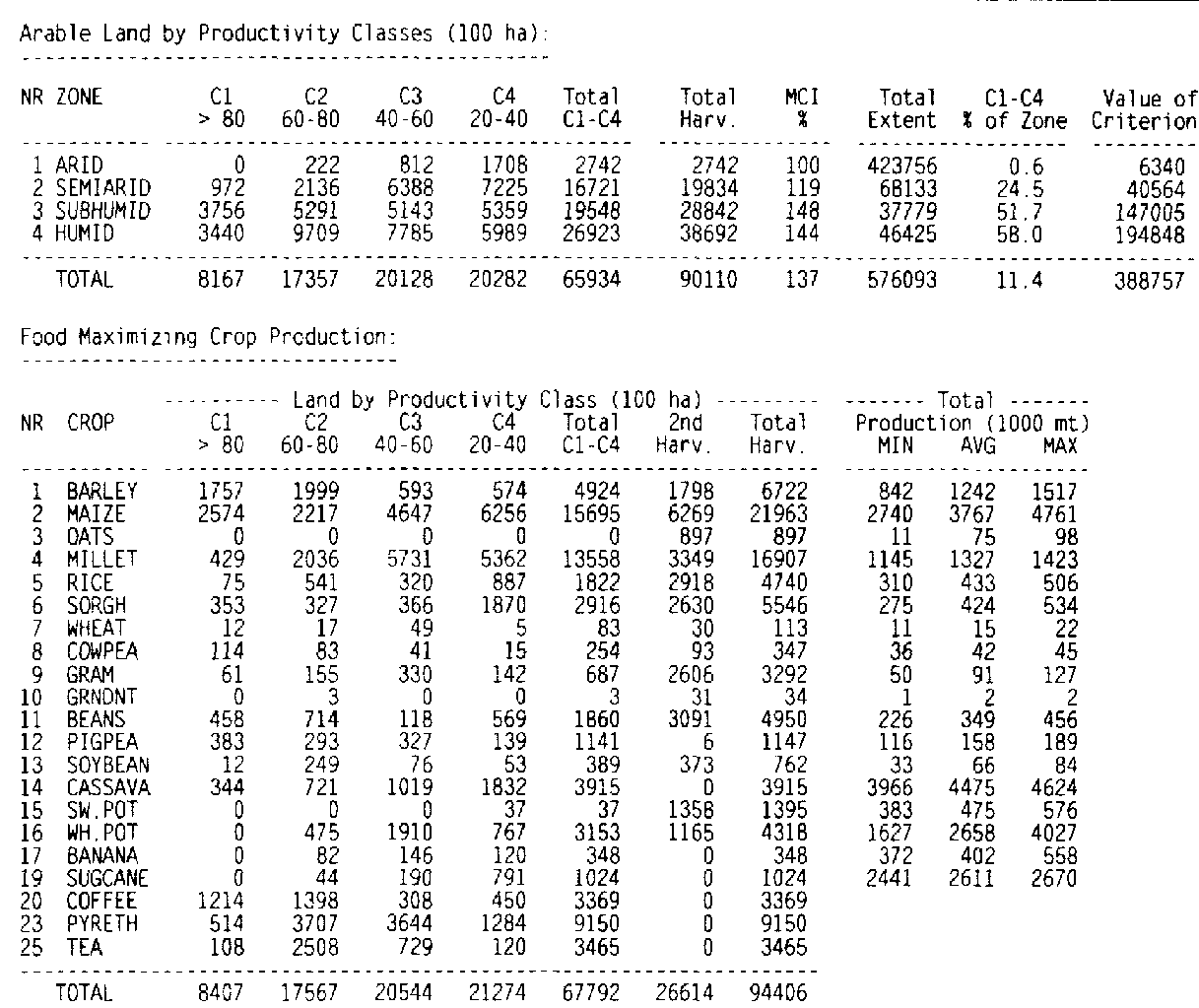
TABLE 2.4 Kenya food production potential at intermediate input level
The estimates of arable land were grouped according to mean total dominant LGP into four broad climatic zones: the arid zone (areas with mean total dominant length of growing periods < 120 days), the semi-arid zone (areas with LGPs of 120 to 179 days), the sub-humid zone (areas with LGPs in the range of 180 to 269 days), and a humid zone (areas with LGPs >270 days). Extents of arable land (classes C' to C4) are also expressed as a percentage of total zone area.
In the calculations, all land marked in the resource inventory as forest zone and/or game park is excluded. The extent of potentially cultivated land in Kenya, under the conditions described above. amounts to some 6.6 million ha. 2.6 million ha are adjudged very good or good potential (classes C1 and C2), 2.0 million ha are rated moderately productive (class C3). The balance, another 2.0 million ha, is of low potential (class C4),
The arable extents in classes C1 to C4 account for 11.4 percent of Kenya's total land area. In the sub-humid and humid zones 52 and 58 percent, respectively, of the land is rated suitable for rainfed crop production, and about 1/4 in the semi-arid zone. Maize and millet would account for 2.9 million ha of arable land. The estimated multi-cropping index amounts to 137 percent. The subhumid and humid zones, although only accounting for about 15 percent of Kenya's land area, contribute some 70 percent of potentially arable land.