![]()
![]()
![]()
10.1. GT-Net (Global Terrestrial Observation Network)
10.1.1. The linking of terrestrial networks was seen to be a central activity in the future functioning of GTOS. GTOS could also play a role in encouraging networks that have similar objectives or geographic coverage to merge or to identify ways in which they could be more efficient in taking their observations.
10.1.2. James Gosz presented GT-Net and the demonstration project to be developed by the participating networks. The objective of GT-Net is to better understand global and regional change by linking existing terrestrial observation networks. The key activities will be to define a clear policy on data and information access; to share and exchange environmental data; to develop a set of standards for metadata as well as local/regional/global in situ data sets; and to undertake demonstration projects, the initial one being to estimate primary terrestrial productivity. Initially, GT-Net will focus on those networks that regularly make in situ terrestrial and freshwater measurements. Over the longer term, it will strive to meet the needs of the other Global Observing Systems on terrestrial issues relating to climate and oceans.
10.1.3. GT-Net will undertake projects which demonstrate the effectiveness of linking existing networks by generating data sets which are useful in studying global change. This will serve as a test bed for collaboration among networks and sites, including data sharing and exchange, and obtaining the experience needed for further development of the global terrestrial network. The first project will concentrate on improving current estimates of global terrestrial primary productivity. It will adopt a hierarchical approach and use models which combine both satellite data and in situ observations. A set of output products, which have Net Primary Production (NPP) as their common foundation, will be produced. The NPP project has two primary goals: to distribute a global standard NPP product to regional networks for evaluation; and to translate this standard product to regionally specific crop, range and forest yield maps for land management applications.
10.1.4. The U.S. Long-Term Ecological Research (LTER) Network Office (NET) will provide scientific and technical support toward the development and implementation of GT-Net. These activities will be under the direction of the NET Associate Directors for Information Management, and Technological Advancement (James Brunt and John Vande Castle). The terms of reference were endorsed by the GTSC.
10.1.5. The GTSC endorsed the development of GT-Net and of demonstration projects, including the first one on Net Primary Production. The following recommendations were made:
Recommendation 8: GT-Net should not be limited to those networks that attended the meeting in Guernica (Experts meeting on Ecological Networks, 17-20 June 1997, Guernica, Spain). Additional other networks should be encouraged to participate in order to have a wider representation of terrestrial issues (e.g. forests). The networks should be invited according to specific criteria defined by GTOS.
Recommendation 9: a brochure should be developed explaining the demonstration project on NPP as well as the valued added it will bring to the sites/networks participating in GT-Net.
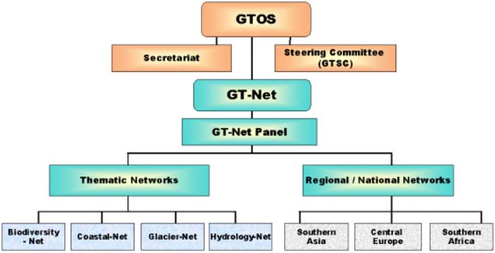
10.1.6. The Committee recognized that, with the establishment of other GTOS Networks, the term "GT-Net" was in danger of being misunderstood. It was agreed that GT-Net would refer to a system of networks, each representing a specific thematic orientation for a region of the globe or a regional effort among the nations of that region (see diagram below). Each regional network represents an organized effort, either for a particular theme or habitat type (e.g., glaciers, forests, permafrost) or among adjacent countries (e.g., Poland, Hungary). These organized efforts are extremely important to the functioning of GTOS because they represent collaboration and integration efforts that are maintained outside of the GTOS activity and its limited resources. The networks supply not only site-specific information of value to GTOS but also syntheses of information at regional levels.
10.1.7. It is important to recognize the distinction between the two types of regional activities. The thematic networks can provide specific types of information, often a result of standard measurements unique to the theme (e.g., permafrost). The national networks are comprised of sites representing many different types of habitats (e.g., forests, lakes, coastal areas) and may have core topics (e.g., biodiversity, productivity) that can provide a different type of synthesis. There may, and perhaps, should be interactions between the two regional network types as a particular site can be represented in a certain thematic effort as well as an integrated national effort.
10.1.8. Each of the regional networks represented (see diagram) in GT-Net will have a person designated by that network who will serve on a GTOS Network Panel (GT-Net Panel). In this way, each type of network will have a voice in determining how GTOS will operate and the directions in which it will move. The various thematic and regional national networks will host their own meetings and determine their own governance rules.
10.1.9. The GT-Net Panel will provide the GTSC with scientific and technical guidance on all matters relating to the implementation and operation of GTOS observation programmes, including practical advice on means to facilitate on-going operations. The GT-Net Panel will be composed mainly (about 75%) of scientists designated by the regional networks participating in GTOS, and members of the GTSC (about 20%), plus a few (5%) independent scientists of distinction who may have no direct role in GTOS and its network.
ACTION: Chairman of the GTSC to send a letter to the networks that attended the meeting in Guernica informing them of the changes in the structure of GT-Net.
10.2. Network of Glacier Sites (NGS)
10.2.1. This proposed network would be based on the existing World Glacier Monitoring Service (WGMS) network, which coordinates the annual monitoring of 60 glaciers globally representing tiers 2 and 3 of the GHOST concept. The gaps identified so far concern tier 4 and 5, as well as the lack of sites in New Zealand. Among the actions undertaken for the establishment of a Glacier Network, the TOPC - the lead panel in the establishment of this network - developed a strategy document, guidelines for sites participation and a letter to national contacts. WGMS has agreed to work together with GCOS to form a climate change network.
10.2.2. It was noted that the network's relevance lies not only in its contribution to understanding climate change, but also in the information it can provide at national and sub-regional levels on factors influencing water availability and hence production in semi-arid to arid mountain areas and down stream hydrology in arid ecosystems. This is an important additional reason for accepting networks as part of GTOS, and in particular the Glacier Network.
10.2.3. The GTSC endorsed the action taken so far and the progress achieved, adopted the Glacier Network as a GTOS Network and approved proceeding with its establishment. It was suggested that the Glacier Network should have elements indicating the support to science and benefits to developing countries.
10.3. Permafrost Network
10.3.1. Contacts had been made with Jerry Brown of the International Permafrost Association (IPA) to determine interest in working together on the establishment of a Permafrost Network. The Circumpolar Active Layer Monitoring (CALM) network - currently consisting of 59 sites in the Northern Hemisphere - could form the basis of this network. The next steps are to develop foundation documents (strategy paper, guidelines for participation, letter of invitation to sites/networks), to identify gaps in coverage and to develop a strategy to fill these (in collaboration with IPA). IPA has agreed in principle to work together to form a climate change network, but a letter should be sent to its Director to formally establish it.
10.3.2. The GTSC endorsed the action taken so far and approved in principle the formation a Permafrost Network. The participants considered it important that the Arctic Monitoring and Assessment Programme (AMAP) be contacted regarding participation in the proposed Permafrost Network.
Recommendation 10: closer collaboration between the Arctic Monitoring and Assessment Programme (AMAP) and International Permafrost Association (IPA) should be considered and encouraged.
10.3.3. The participants underlined the need to find ways of bringing similar networks to work more closely together under the GTOS umbrella.
10.4. Hydrology Network
10.4.1. At its last meeting, the TOPC made the following recommendations for action that should be taken prior to the establishment of a Hydrology Network:
- assess the availability of historic international stream discharge records to the TOPC user community;
- in collaboration with the Global Runoff Data Centre (GRDC), investigate the feasibility of routinely providing, on behalf of GTOS, certain specific discharge observations at global or continental scales in the future;
- assess the availability of Flow Regimes from International Experiments and Network Data (FRIEND) data sets to the G3OS community;
- assess linkages of GCOS and GTOS to the World Hydrological Cycle Observing System (WHYCOS) Network and the availability of WHYCOS data for climate purposes;
- develop or encourage the development of a hydrological network of pristine discharge stations for climate purposes.
10.4.2. The GTSC recognized that a hydrological network is critical for many of the GTOS issues. It endorsed the proposed course of action and agreed that efforts should continue in assessing feasibility of establishing this network.
![]()
![]()
![]()