Part 1: Mapping of rainfall-induced erosion processes
1. General context
2. Common consolidated methodology
3. Procedures
4. Implementation aspects
1.1 Hitherto experience in mapping of rainfall-induced soil erosion in the region
1.2 Justification for a common consolidated Mediterranean methodology
1.1 Hitherto experience in mapping of rainfall-induced soil erosion in the region
In order to prepare a common methodology for rainfall induced soil erosion mapping in Mediterranean coastal areas, the state of the art on soil erosion mapping has been assessed. The aim was to investigate and analyze existing methodologies and/or mapping of soil erosion to find out common elements and correlations and to point out which methodologies and mapping are most suitable for a variety of scales and problems.
The investigation has been carried out analyzing information collected by FAO, A. Giordano and L. Rojo (1988) or directly supplied by national technical staff.
Twenty-nine different erosion maps were analyzed. They were grouped according to their approach and objectives. Two topics have received special attention: present rainfall induced erosion rates with seven mapping examples and soil erosion risks in seven cases.
The remaining 15 maps were dealing with other topics such as:
soil erosion assessment using
sedimentation data |
2 maps |
rainfall and wind induced erosion
data (qualitative assessment) |
2 maps |
current state of soil erosion,
landslides and mass movements |
6 maps |
wind erosion risk |
1 map |
desertification |
1 map |
protection of natural resources
and ecosystems |
1 map |
use of remote sensing |
2 maps |
The following are some examples of quantitative mapping of rainfall-induced erosion:
• "Provisional map of the present degradation rate t/ha/yr. (FAO/UNEP/UNESCO, 1980), referring to the Middle East and North Africa (scale 1:5,000,000).
• "Mapa de estados erosivos (t/ha/yr)" (ICONA, 1988). The map scale is 1:400,000.
The two above-mentioned maps are based upon USLE but with considerable modifications, especially as far as the rainfall erosivity is concerned. This approach still needs practical experimentation.
Other maps dealing with the current rainfall induced erosion rate are those of ICONA (1982), Gazzolo and Bassi (1966), Gavrilovic (1962), Lazarevic (1985), Michaelides (1989) and Ciccacci et al. (1988).
As related to the qualitative approach of soil erosion risk, it is convenient to mention the map "Soil erosion risk and important land resources in the southern EC countries" (DG XI, EC, 1989 CORINE Programme). The aim of CORINE is to set up a working prototype information system (GIS) on the state of the environment and natural resources in the European communities. The project "Soil erosion risk" is only one, though important, part of the CORINE programme which covers issues such as biotopes, air quality, land cover, coastal erosion etc. The methodology involves separate assessment of two different, although related, indices of soil erosion risk i.e. the "potential soil erosion risk" and the "actual soil erosion risk".
A comparative analysis of erosion risk classes and those of important land resources provides accurate information on the priority area to be protected.
For a full description and critical analysis of the cartographic documents see Giordano e Marchisio (1992).
The difference between the two approaches (current rainfall induced erosion and erosion risk) is not so deep since both of them are using the USLE methodology with a certain number of modifications. A starting approach based on the risk concept that may be called "predictive" is important but it appears static. Combining the predictive method with a descriptive one in which emphasis is placed on the erosion processes, a sound cartographic base might be available with experimental field. Out of CORINE which is of very small scale, no medium to large-scale erosion mapping for both quantitative and qualitative assessments are available.
The overall analytical inventory of the state of the art of erosion mapping in Mediterranean coastal areas leads to two basic conclusions:
• the hitherto prepared maps provide data on either predictive or descriptive aspects of soil erosion processes;
• a number of different approaches, methods and scales have been used up to date, hindering any systematic correlation and integration.
Therefore the basic task of the PAP/ICONA/FAO project "Erosion mapping in Mediterranean coastal areas" was to overcome the above referred constraint i.e. to make available a new medium to large-scale consolidated and adequate mapping tool applicable in all Mediterranean countries.
1.2 Justification for a common consolidated Mediterranean methodology
In the overall and very broad field of earth sciences, there has always been a basic and strong need for the graphic presentation of landscapes and geomorphic dynamics, that means systematic mapping to be used as both a descriptive and thematic surveying tool.
Mapping procedures have been progressively established and related to basic criteria, such as the reference theme, scale, accuracy, legend and symbols; main fields of application have been topography, geology, soil classification and more dynamic topics such as vegetation cover, land use, agronomic constraints and man-induced degradation.
Spatial reference frameworks were almost always the state or country boundaries since original and local mapping modalities were to some extent meant to secure and protect specific territories and to help preserving national identities.
As communications, interrelations and cooperation norms between countries improved, there was an increased need for more and more integrated and enlarged management strategies at sub-regional, regional or even continental levels. These opening processes implied common standardized and homogenized technical and scientific tools and languages amongst which surveying, mapping and classifications are to be considered as essential. This was particularly relevant for soil surveying and mapping when at least three different basic schools and approaches had produced important amounts of cartographic and statistic materials for which considerable funds and efforts had to be spent for their further correlation and more universal use.
In the specific field of soil erosion mapping most of the Mediterranean countries have elaborated a great amount of mapping systems and legends referring to a large variety of critieria and parametres which always lead to two main approaches: predictive erosion status or erosion processes description.
Up to date, only very small-scale erosion maps integrating both erosion potentials and active erosion processes are available, while there is an ever more urgent need for large-scale integrated erosion maps for regional and sub-regional planification purposes, as well as for the identification of priorities and of preventive (on the basis of potential erosion status) and curative (according to actual erosion problems) measures to be improved. Common action in these fields and at the scale of overall Mediterranean coastal areas are still strongly hindered by the lack of correlation and normalization of the extremely diversified erosion mapping concepts within rather reduced geographical areas.
The proposed common consolidated Mediterranean erosion mapping methodology has been elaborated to avoid this type of constraint and restrictions by providing common criteria leading to common scales of erosion intensity and priorities as identified through the final mapping data and diagnosis. Standard problem inventories and diagnosis should lead further on to common planning and management policies or strategies able to overcome national and cultural boundaries for the benefit of enlarged geographic units, such as the Mediterranean coastal areas.
2. Common consolidated methodology
The common consolidated methodological erosion mapping scheme is the result of two complementary approaches combining the advantages of a broad variety of surveying, processing and mapping techniques. In this exercise, key contributions were provided by DGCONA as the lead institution and FAO providing scientific and technical advise.
Two main basic approaches have been taken into account, namely:
• Predictive by identifying, assessing and integrating all basic parameters, such as physiography (slopes), lithology and/or soils, land, vegetation cover, in view of determining preliminary assumptions on erosion risks (erodibility - potential erosion);
• Descriptive when describing and qualitatively assessing current on-site and active erosion processes.
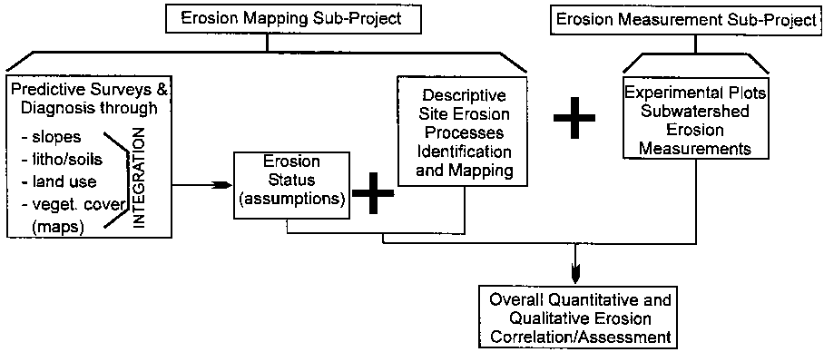
The consolidated scheme has been prepared so as to match with parallel measurement operations meant to evaluate actual soil loss by measuring discharges in experimental plots and/or sub-watersheds affected by specific and well representative erosion constraints.
The various operation sequences and steps related both to measurement and mapping are schematically shown in Fig. I-1.
The predictive approach provides considerable advantages in the initial surveying phase, such as speed, relatively low cost and less need for experienced staff.
Descriptive surveying is to be considered as complementary to predictive surveying, since it provides basic "field truth" which is either to consolidate or partly invalidate both active and potential erosion diagnoses.
The final consolidated approach requires various methodological steps within a general sequence where the main phases consist of basic erosion status mapping, processing and adjustment of intermediate basic erosion status map, and site descriptive erosion process mapping.
Basic reference grids and maps should be of a medium to large scale, thus providing clear contour-figured topographic information.
As far as basic erosion status mapping is concerned, the following specific factors and parameters are considered:
• Topographic slope units and classes expressed in degrees or percent.
• Lithology/parent material/soils, where emphasis is put on mechanical resistance and capacity of the various "lithofacies", rocks or loose sediments rather than of their petrographic or mineralogical peculiarities; the legend ranges from non-weathered hard and compact rocks to medium or strongly weathered material, and loose, non cohesive sediments.
• Present land use and vegetation cover are mainly identified by photo-interpretation; their overlapping and correlation determine the level of soil protection.
• Erodibility levels are determined by overlaying slope values and lithology maps (see 3.2 Predictive Approach, Step III).
The final erosion status map is the result of overlaying and correlating the maps of level of soil protection and erodibility levels.
The site descriptive erosion process, surveying and mapping, is performed through combined photo-interpretation and field control using the readjusted intermediate scale erosion status map as the new cartographic reference canvas, which means that active and specific erosion-affected areas and units are to be delineated by sub-boundaries inside the erosion status unit arid and boundaries.
Figure I-1. General sequence of erosion mapping and measurement methodologies
The systematic mapping of qualitative and dynamic erosion features identifies two broad categories of geographic environments: morphologically stable, non-erosion-affected areas; and unstable, erosion-affected areas.
As related to the first category, a qualitative assessment is provided for erosion risk or potential erosion, identifying at field level, the various parameters considered for the basic predictive erosion status map and assessing their comparative de-stabilizing force. The latter should lead, in each specific case, to the identification of the main or most probable causative factor of medium- to high-erosion risks by means of codes and symbols given in the more detailed legend description (Chapter 2.2).
As far as erosion-affected areas are concerned, the descriptive and qualitative erosion mapping identifies the nature of specific erosion processes, their comparative importance expressed in terms of extent, size, depth or volume, and their expansion rate or trend based on field observations indicating either a recession or an increase of erosion activity.