The consolidated erosion map legend has been kept open and flexible enough to be adequate and adaptable to a reasonable variety of specific Mediterranean geographical backgrounds which are all related to coastal zone environments, but with numerous local micro-climatic, lithologic and land use variables. Special emphasis has been given to the following aspects:
• agro-ecological or big-geographical zoning for different mapping scales and surveying conditions;
• soil surface state assessment (surface crusting and sealing) and the consequences on run-off and infiltration water dynamics);
• mechanical and/or chemical changes occurred in soils as a result of specific cropping or land use techniques (compacting)1;
• specific identification and assessment of erosion-affected areas due to infrastructure
1 Features to be considered as part of the lithology/parent material parameters to be integrated in the phase of erosion status mapping depletion (roads, old terraces, check dams, etc.).
Overall geographical environments can be subdivided in two broad categories:
• Stable, non-erosion-affected areas, and
• Unstable, erosion-affected areas.
The erosion map legend as described in Box 1 has been prepared according to the referred landscape classification as a basic reference framework and a guide to both a predictive and descriptive diagnosis.
BOX 1: Legend
A. PREDICTIVE
MAPPING: INFERRED GLOBAL EROSION HAZARDS |
|
Symbols |
|
(0) |
none (Equivalent to stable
non-used wasteland in descriptive mapping: 010) |
(1) |
very slight |
(2) |
slight |
(3) |
moderate |
(4) |
severe |
(5) |
very severe |
B. SITE-DESCRIPTIVE
MAPPING: GRADE OF STABILITY/EROSION PROCESSES1 |
|
I. Stable,
non-erosion-affected areas (*) |
|
00 |
stable, non-used wasteland
(rock outcrops, cliffs, stony or sandy areas) |
01 |
stable, unmanaged areas with
potential for forestry use only |
02 |
stable, unmanaged areas with
agricultural potential (crops and pasture) |
03 |
stable, managed areas with
forestry use only |
04 |
stable, managed areas with
agricultural use (crops and pasture) |
• Rehabilitated
areas by means of: |
|
05 |
natural or artificial
re-vegetation |
06 |
physical infrastructures
(terraces, check dams, etc.) |
*Grade of instability risk |
|
Assessment of instability risk for
all stable environments (00 to 04) and of risk for
rehabilitated environments, i.e. 05+06 (i.e. a
risk in the first years of rehabilitation;) to be
expressed by a complementary digit (0 to 3) to the
original stable unite' code: |
|
|
|
1: Low to moderate |
|
2: High |
|
3: Areas in
hazardous/precarious/critical state (Stability threshold
= highest grade of instability risk) |
|
Example :
|
|
*Identification of main
causative agents |
|
Instability risk assessment
may be reinforced by the identification of its most
probable/prevailing causative agents inherent in
the landscapes' main basic components, i.e.: |
|
|
|
g: Geology |
|
v: Vegetation |
|
h: Human activities |
|
a: Animal activities
(trampling, terracing, etc.) |
|
Extra codes might be freely added
according to local specific contexts and situations. |
|
Example: 023 g =
stable managed areas with erosion risk mainly due to
geologic factors. |
|
II. Unstable areas
(**) |
|
• Splash
erosion |
|
A1 |
localized (<30% of the
area is affected) |
A2 |
dominant (30-60%) |
A3 |
generalized (>60%) |
• Sheet
erosion |
|
L1 |
localized |
L2 |
dominant |
L3 |
generalized with soil profile
removal |
Lx |
= unreclaimable areas due to
total soil removal |
• Rill erosion |
|
D1 |
localized |
D2 |
dominant |
D3 |
generalized |
• Gully
erosion |
|
C1 |
individual gullies |
C2 |
localized gully networks |
C3 |
dominant |
C4 |
generalized |
Cx |
= unreclaimable areas due to
generalized band lands |
• Wind erosion |
|
E1 |
localized loss of
topsoil/overblowing/deflection |
E2 |
dominant |
E3 |
generalized |
Ex |
= unreclaimable areas due to
total sand or sediment burying or topsoil removal |
• Mass earth
movements |
|
M1 |
local gravitational soil
creep/solifluction |
M2 |
localized land slides/mudflows |
M3 |
dominant |
M4 |
generalized |
MX |
= unreclaimable areas due to
total slope slides |
Symbols |
|
• Water or
sediment excess |
|
W1 |
areas periodically flooded
and/or sediment buried |
W2 |
areas permanently flooded
and/or sediment buried/waterlogged areas |
• Degradation
induced by land management |
|
S1 |
soil compacting |
K1 |
soil crusting |
Z1 |
cattle trampling/terraceting |
H1 |
salinisation |
• Associated
processes |
|
See "Note" in pare (**) |
|
Multiple processes |
|
P1 P2 P3 etc. (for description of
different closely interacting erosion processes) |
|
**Erosion expansion trend
(rate) |
|
Assessment of erosion rate/trend
for all unstable erosion-affected areas to be
expressed by a complementary digit (0 to 3) to the
original unstable units' code: |
|
|
|
1: Trend to local expansion or
intensification |
|
2: Trend to widespread expansion
or intensification |
|
3: Trend to increase generalized
degradation towards an irreversible state |
|
Example: |
|
|
|
L23 = dominant sheet erosion with
a trend towards generalization and an irreversible state
(Lx type units) |
|
Note: All multiple or mixed
but clearly identifiable erosion processes can be mapped
by associating or combining the corresponding codes (the
sequence of the codes should be established according to
the relative importance of the processes: first code =
the most important process): |
|
|
|
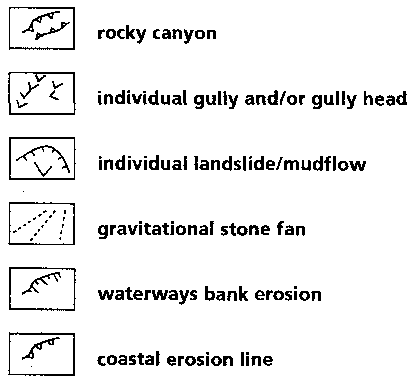
Point/line erosion data (Individual erosion processes)
1 Refer to the glossary for the definition of terms
3.1 General methodological scheme
3.2 First phase: Predictive approach
3.3 Second phase: Descriptive approach
3.4 Third phase: Integration
3.1 General methodological scheme
As already referred to in the general description of the methodology (Ch.2.1), the basic procedure scheme consists of 3 clearly defined phases:
• Predictive phase which leads to the mapping of erosion status homogeneous units providing the basic cartographic canvas as far as general erosion potential and trends are concerned;
• Descriptive phase which identifies and assesses actual on-site erosion processes as well as the different grades of erosion proneness and evolution trends;
• Integration phase the main output of which is the final consolidated rainfall-induced erosion map as a result of overlapping and integrating predictive and descriptive qualitative data.
The predictive phase mainly consists of desk and office data processing by means of 7 different steps:
• Steps 1 and 2: Preparation of slope classes and lithofacies maps;
• Step 3: Erodibility map by overlaying slopes and lithofacies;
• Steps 4 and 5: Preparation of land-use and vegetation cover maps;
• Step 6: Soil protection map by overlaying land use and vegetation cover maps;
• Step 7: Erosion status map by overlapping erodibility and soil protection maps.
The descriptive phase is basically performed in the field by direct observation and control, using the predictive erosion status map as both a cartographic and thematic reference canvas. Field observation should be supported by photo-interpretation, particularly during the preliminary steps which consist of the identification of the stability grade, dominant erosion processes and evolution trends within the various erosion status units.
The integration phase produces the final consolidated erosion map by consolidating all predictive and descriptive data.
The comprehensive graph shown in Fig. I-2 summarizes the overall methodological sequence and clearly identifies the various mapping phases including the final integration leading to the consolidated erosion map.
For all overlaying and integration procedures envisaged, the use of GIS as an efficient tool, highly appropriate for the decision-making process, is recommended.
It is emphasized that the purpose of the map and its future target users have to be clearly defined before starting with the mapping exercise. Erosion mapping cannot be understood as an end itself, but must always aim for indicating needs for and possibilities of future soil conservation activities by the means of planning both short term curative programs and longer term preventive policies. The respective planning steps will include the identification of extreme situations as well as future priorities of action and the respective curative / preventive measures.