![]()
![]()
![]()
2.1 PRA methods and tools
2.2 Organizational aspects
2.3 Analysis and reporting
2.1.1 PRA training
2.1.2 Common resource and user group inventory
2.1.3 PRA methods and tools used
2.1.4 Participatory planning methods and tools used
When it was decided in mid-1995 to organize a new revised round of PRAs and Participatory Planning in selected sites of the Bhusunde Khola watershed, it was also agreed that it would be preferable to train project staff in PRA methods and techniques, and that trained project staff should be responsible for carrying out these PRAs. This was perceived to have the following advantages:
(i) Capacity building of the DSC, institutionalizing knowledge and skills essential in effective participatory working methods;(ii) Increase the affinity of the project staff with the plans produced, and an expected improvement in commitment to implement these plans; and
(iii) Cost reduction as compared to PRAs carried out by sub-contracting NGOs.
A 7-day PRA training course was organized from 10-16 October 1995. The training course was held in the Bhusunde Khola watershed and was conducted under sub-contract by the NGO "New ERA". The 20 participants included 13 project staff (5 group promoters, 2 motivators, 5 mid-level technicians and 1 mid-level administrative support staff) as well as 7 representatives from other line agencies (4). Tools and techniques included in the training were:
4 See also Field Document 2/96, "A training report on participatory rural appraisal (PRA) methodology (including socio-economic information of the Tutunga village of Chhoprak VDC, Gorkha District, Nepal)", prepared by New ERA.(a) Time-line, Ethno-history and Seasonal Diagram for time related data;
(b) Mapping (social, enterprise, topography and hydrology) and Transects (historical, nalla and agro-ecological) for spatial data;
(c) Diagramming (pie, Venn and trend) for quantitative data;
(d) Preference or verbal ranking, matrix ranking and wealth ranking
(e) Use of secondary data;
(f) Semi-structured interview;
(g) Observation; and
(h) Triangulation and cross-checking for reliability.
The training was remarkably successful since it enabled the project staff to independently complete a large number of additional PRAs.
Between September and December 1995 a systematic Common Resource and User Group Inventory was carried out in the whole Bhusunde Khola watershed by the National Expert Local Capacity Building, Mr. D.R. Chapa, assisted by Mr. Chalitra Joshi and the local Group Promoters. The objectives of this inventory were to:
(i) Identify all existing and potential user groups, their nature (e.g forest user group, women group), size, past and on-going activities, training received, and financial situation.(ii) Identify all common resources, notably forest, water and pasture, that could benefit from management, conservation or development activities through existing or newly to be formed user groups.
The data provided by the inventory were extremely relevant for the capacity building of user groups: it identified many inactive groups, as well as promising newly formed groups (especially women groups). The resulting database, which is periodically updated, is primarily used by the National Expert Local Capacity Building and the Group Promoters.
The Common Resource and User Group Inventory was in many ways similar to, and could be part of reconnaissance visits. It was so relevant for the further PRA process that it should actually be seen as integral part of the participatory development itinerary:
(a) The inventory provided detailed field knowledge that enabled the project to identify and select appropriate sites (hamlets or groups of hamlets) of more or less homogeneous communities for PRA and participatory planning;(b) The inventory helped to identify key-informants, as well as local social infra-structure (existing credit schemes, presence of line agencies, NGOs, etc.);
(c) During the actual PRAs the farmers enthusiasm grew when they noticed that the PRA teams already knew much about their village and its resources, and it also helped in the preparation and interpretation of the participatory maps.
(d) It facilitated relations with villagers, who interpreted the detailed knowledge of the PRA teams as a proof of genuine interest in improving the living conditions in their village.
A full fledged PRA can take a very substantial period of field work and analysis to complete. The scheduled duration and the actual PRA methods and tools used, depend on the objectives of the PRA exercise. In this case, the main objective was clearly to enhance the participatory planning process. Furthermore, it should be noted that in a number of sites this was not the first PRA exercise.
It was essential to involve all relevant parties in the PRA and planning process in each of the selected villages. Consequently, the size of the communities where PRAs were to be conducted was small, usually between 30 to 80 households, and the duration of the PRAs was limited, especially to allow women to fully take part in the exercise. Typically the PRA itself took about two full days, while a third day was devoted to data analysis and compilation for a feed-back presentation during the fourth day, which was further devoted to participatory activity planning.
The actual PRA methods and tools used and recorded in most of the PRA sites include:
1. Time Line, which provided information on ethno-history, and history of forest, cropping systems, livestock, and issues like major landslides.2. Transects, generated agro-ecological data and provided good occasions for the identification of problems and the discussion of opportunities.
3. Mapping exercises included Resource and Social Maps. The resource maps were often quite detailed, and could be used later in impact evaluation and re-planning exercises.
4. Wealth ranking was usually based on food sufficiency of the individual households, it thus provided additional information on food security in the watershed.
5. Seasonality Diagram were used for rainfall, cropping patterns, fodder use and availability, food availability, busy farming days, milk production, animal diseases and expenditures. The most valuable data revolve around the cropping patterns and busy farm days, since these data were found to be essential in the detailed planning of activities implementation.
6. Pie Charts were used to illustrate population (gender and ethnic composition), literacy data, livestock herd composition, land use, cropping patterns (types of crop per land type, or per season, varieties of paddy, maize and wheat), forest types, fuelwood supply sources and sanitary habits.
7. Trend Diagrams were used for population, literacy rates, crop production (different crops), livestock numbers, forest area, erosion problems and attitudes towards community organizations.
8. Matrix Ranking was used for crop varieties and fodder trees.
Before starting the actual participatory planning of activities, the results of the PRA generated data are presented to the community for verification and comments in a feedback or restitution meeting. This is also the starting point of the Village Planning Workshops, during which the following exercises were carried out, resulting in the formulation of a Community Action Plan:
1. Verbal ranking of problems and opportunities, during which a list of problems and opportunities is drawn up (ideally this list should closely reflect the results of the presentation of the PRA data);2. Prioritization of problems and opportunities, which consists of a broad discussion and reshuffling of the listed problems and opportunities;
3. Listing of activities, based on the prioritized problem and opportunity list; and
4. Prioritization of activities, based on the listed activities and a broad discussion on actual possibilities to carry out such activities.
5. Delegation of responsibility, or WHO should do WHAT.
2.2.1 Site selection
2.2.2 Team formation
2.2.3 Venues and timing
The following site selection criteria were utilized to decide where PRAs should take place within the Bhusunde Khola watershed.
(i) It had earlier been proposed that the project should concentrate its activities in a particular area or sub-watershed, in order do be more effective in this area and provide an attractive model for replication. For practical reasons (accessibility and distance from the project Base Camp facilities in Chorkate), it was decided in 1995 that the Wards No. 7, 8 and (parts of) 9 of Chhoprak VDC would be designated as project concentration area. Consequently, it was decided that this concentration area should be fully covered by PRAs (with the exception of point iii).(ii) The rest of Chhoprak VDC, and the three other VDCs of the Bhusunde Khola watershed, Ampipal, Harmi and Khoplang, would also have to be fairly represented in the PRAs and planning of activities. This to fulfil the project mandate, to continue the participatory development partnership and development efforts, and to avoid political problems. However, it was agreed to minimize PRA sites in these areas as far as acceptable (5).
5 In fact, the number of actual PRAs carried out was larger than intended because being left-out was not acceptable for several communities outside the concentration area.(iii) Within the overall watershed area primary attention should be on the villages on the slopes and ridges, rather than those along the river in the valley.
Based on these criteria a number of sites were selected for PRA and planning. However, during the course of the PRA exercise a number of communities that had not been selected strongly urged the PRA field teams to also include their communities, which was sometimes difficult to refuse.
The overall lead in the PRAs was taken by the National Expert Local Capacity Building, Mr. D.R. Chapa. It was decided to form relatively small PRA teams, each led -preferably- by one of the project mid-level technicians that participated in the October 1995 PRA training. These teams would than also consist of a (female) group promoter, equally trained in PRA, plus one or two other persons, either support staff, or interested and PRA-trained technicians from other line agencies.
The following persons took part in the PRA field work: D.R. Chapa (National Expert and PRA coordinator); M.L. Joshi, T.B. Shrestha, I.J. Thapa, H.R. Khanal (mid-level technicians/area facilitators); Ms. D. Lamsal, Ms. N. Bhattarai, Ms. K. Pokharel, Ms. S. Ghimire, Ms. I. Marahatta, Ms. S. Pokharel (group promoters/motivators); N. Maskey, Ch. Joshi, Ph. Pokharel, H.R. Pokharel, N. Hada (other support staff); as well as R.B. Kunwar from the District Agriculture Office and K.P. Bhattarai from the District Livestock Services.
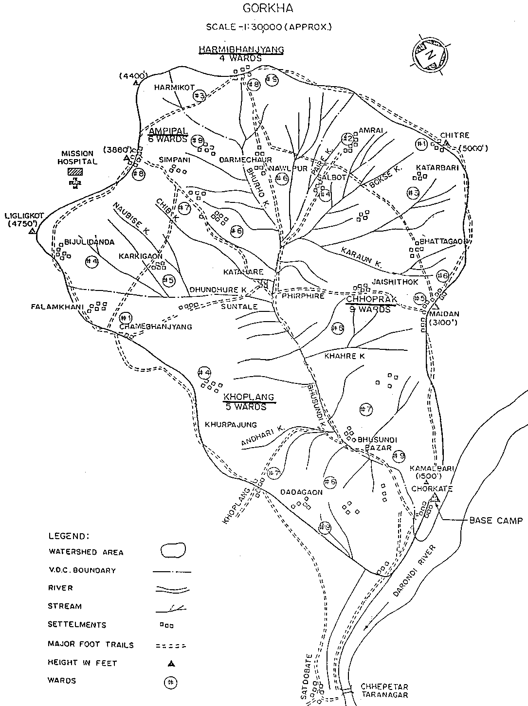
PRA and planning was carried out in 26 sites between October 1995 and January 1996 (see Table 1 and Figure 1).
The total number of project days (not staff days) spent was 97, and the average duration of the PRAs was 3.9 days per site.
These 26 PRAs provided an overwhelming amount of raw information. They also provided a list of more than 200 activities that were prioritized for implementation in the Community Action Plans - though some would later be rejected following feasibility and other criteria. High levels of expectations were raised in the watershed, and the limited project resources had to be fully mobilized to assist the local communities in the implementation of their Community Action Plans, and data analysis had to be postponed. Similarly analysis efforts were more focussed on the Community Action Plans and their feasibility than on the background data provided by the PRAs. A Community Action Plan computerized database (in Excell) was set up by Ms. H. Qwist-Hoffmann, Associate Professional Officer Watershed Management.
Table 1. 1995/96 Bhusunde Khola watershed Participatory Rural Appraisal and planning sites, dates, duration and teams involved.
|
|
Ward |
Site |
Dates |
Days |
Team |
|
Ampipal |
5 |
Ratdanda |
|
3 |
I.J. Thapa |
|
6 |
Simpani |
|
3 |
T.B. Shrestha |
|
|
7 |
Simpani Hatiya |
|
3 |
T.B. Shrestha |
|
|
9 |
Darmichaur |
|
4 |
T.B. Shrestha |
|
|
Chhoprak |
1 |
Chitre |
|
4 |
Ch. Joshi |
|
2 |
Chiuribot |
|
1 |
Ch. Joshi |
|
|
3 |
Katarbari |
|
4 |
T.B. Shrestha |
|
|
4 |
Salbot |
|
4 |
T.B. Shrestha |
|
|
5 |
Faudargaon |
|
3 |
I.J. Thapa |
|
|
7 (a) |
Majhgaon |
|
4 |
I.J. Thapa |
|
|
8 (a) |
Tutunga |
13-16/10/95 |
4 |
I.J. Thapa |
|
|
9 (a) |
Katubanse |
|
5 |
M.L. Joshi |
|
|
Harmi |
3 |
Harmi Bhanjang |
|
4 |
D.R. Chapa |
|
6 |
Nawalpur |
|
4 |
D.R. Chapa |
|
|
Khoplang |
1 |
Suntale |
|
4 |
T.B. Shrestha |
|
4 |
Belbas |
|
5 |
M.L. Joshi |
a Project Concentration Area within the Bhusunde Khola watershed.
Figure 1. Bhusunde Khola watershed and the PRA locations
Initial efforts to analyze PRA data were made by Mr. D.R. Chapa and Mr. Ch. Joshi, but they had to abandon their efforts because of lack of time. Finally, the project management recognized that specific competent assistance would have to be sought to analyze the data generated in order to systematize and present the results of the PRAs. This was done during a five week period in January and February 1 997 by the National Consultant Mr. Ashok Poudyel, assisted by Ms. H. Qwist-Hoffmann and Mr. N. Maskey.
A large part of the work consisted of the screening of all available information for actually valid data. Subsequently all valid data were systematically grouped and analyzed. At the end of his rather short assignment, the National Consultant provided the first draft/rough outline of the re-grouped and analyzed PRA data.
In April 1997 the CTA, Mr. F.M.J. Ohler and the APO, Ms. H. Qwist-Hoffmann, agreed to gather all existing and presentable information concerning the 1995/96 PRA and planning exercise in order to present the results in a Field Document that would focus on both the results of the PRA itself (i.e. detailed descriptions of the watershed), and of the participatory planning (i.e. the Community Action Plans).
This would then also permit to assess the quality and quantity of the PRA exercise, as well as of the consistency of the Community Action Plans with the results of the PRA.
The original PRA data, such as maps and diagrams, will be presented separately as an appendix to this report.
![]()
![]()
![]()