![]()
![]()
![]()
ANNEX VIII: COUNTRY REPORT (Cont.)
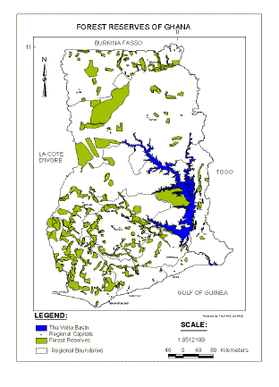
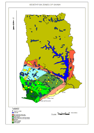
The Republic of Ghana is located between Latitudes 5O N and 11O N and Longitudes 3O 30' W and 1O 30' E in the West African sub-region. With a total land area of 23.85 million hectares and a population of 18 857 000 (1998*), the country has 291 permanent forest estates (fig. 1 above) covering a total area of 2 570 406 ha, which represents 10.78% of the total land area. Generally characterized by a tropical climate, Ghana enjoys warm temperatures with an annual mean falling in the range between 25.5 and 27.0 degrees Celsius. The mean annual rainfall lies between 800 and 2000 mm. A southern third of the country lies in the High Forest Zone while the rest of the country is mainly open Guinea savannah with Sudan and coastal savannahs occurring in the upper-eastern and coastal belts respectively.
After gaining political independence from Britain in 1957, the country's first constitutional government was overthrown in 1966 by the military. A series of military and civilian governments took turns in the administration of the country resulting in a negative impact on the economic development. In 1983, The PNDC Government embarked on an economic recovery programmes that led to a huge reduction in the number of people in the civil service. This left several people unemployed. As the economy began to pick up in the early 90s with a rural electrification programme and road infrastructural development programme, the building industry registered a huge increase. A new era dawned, with the introduction of the Vision 2020 long term Development programme. In a country already beleaguered with a high level of unemployment among the youth, chainsaw machines which were hitherto used in the country mainly for land clearing for agriculture, began to find new uses in the timber sector. Not only were these chain saws used for felling trees, but also as "mini forest saw mills" for the production of lumber in the field to supply construction timber to the ever growing building industry. Uncontrolled tree felling and chain sawn lumber production became the new source of employment for the rural people. In October 1999 The Forest Services Division introduced a ban on the possession and sale of chain-sawn lumber. That certainly is a bold test of theory; but does the Government have the political will to enforce this ban when the election year 2000 is just around the corner?
Ghana has made great strides in economic development over the past decade. With the establishment of the National Development Committee in 1990 (Jafta, 1999) directly controlled by the Office of the president, a long term development vision 2020 was born. This long term vision seeks among others to address:
human resource development through the development of infrastructure such as education, public health, water supply, and the enhancement of the status of women;
economic development that is based on self-sufficiency in food production, development of the cocoa industry, sustainable development of forestry, and the promotion of trade;
rural development through the efficient use of natural resources, rural electrification etc.
Ghana depends mainly on the export of natural resources for economic development. From the above Vision 2020 plan, economic development is hinged on a policy that seeks to increase food production, develop the cocoa industry, sustainably manage forest resources and promote trade. Timber now ranks fourth in exports after gold, cocoa and tourism (David Brown 1999). Ghana's GDP and GDP per capita in 1996 stood at US$7.65 billion and approximately US$400 respectively (JAFTA, 1999).
Social and human context for forestry
A wide spectrum of people have rights, interest or impacts on forestry in Ghana (Nii Ashie Kotey et al 1998). These include traditional land and forest holding authorities, forest fringe communities, farmers, the state and its forest sector agencies, and the timber industry. The importance of forest products in local livelihoods has been recorded in recent detailed studies and efforts are being made to ensure that this is recognized in the actions of Government, traditional landholding authorities and the timber industry. There is a great deal of emphasis on the involvement of communities in forest management, while loggers are expected to enter into social responsibility contracts with the rural communities to make such communities benefit directly from logging activities.
0
Land ownership
Three types of land ownership exist in Ghana: government ownership, individual ownership, and communal ownership. The communal ownership of land centres on the traditional social system of stools which is a very important factor in the formulation and implementation of any forest management plan. Forest lands in Ghana are owned by traditional rulers and held in trust for them by the state through the Forestry Department.
Article 267 of the Ghanaian constitution however stipulates that "All stool lands in Ghana shall vest in the appropriate stool on behalf of and in trust for the subjects of the stool, in accordance with the customary law and usage." All stool lands in practice belong to the paramount chiefs who are traditional heads of paramount stools. The constitution also spells out the distribution of the profit obtained from stool lands, demanding that 10% of the total profit be used for the management of the office of the administrator of stool land 55% of the remaining goes to the District Assembly presiding over the stool land in question. 20% goes to the traditional authority and 25% goes to stools through the National authority for the maintenance of each stool in keeping with its status.
The state of landuse in Ghana is as outlined in table 1 below:
Ghana is endowed with a good cover of natural tropical forest. Ghana's forests are among the best well known in the tropics, at least as regards their botanical content Wong (1989). There are about 650 species recorded. Covering a total of 2.6 million hectares, the permanent forest estates of Ghana are widely distributed over the country with the timber producing area restricted to the south-western portion of the country. This portion is generally referred to as the High Forest Zone. As at the time of writing, the High Forest Zone can no longer boast of any significant cover of forest outside the reserved areas. The first Forest Policy which saw these areas as potential agricultural lands made no provision for their management and this led to a rapid loss of forest cover through shifting cultivation and excessive logging. Fortunately for Ghana, this trend has changed with the introduction of a new policy that looks beyond the reserved forest and encourages landowners and farmers to maintain trees on their farms.
Table 1: Outline of land use in Ghana
Landuse category |
Area (million ha.) |
Percentage of National Land |
(1) forest reserves (2) wildlife conservation area Off reserve high forest zone Plantations Agricultural production area Low used grassland Non tree land |
2.6 1.2 0.5 7.1 1.7 1.2 3.6 6.0 |
11% 5% 2% 30% 7% 5% 15% 25% |
Total |
23.0 |
100% |
Source: MLF(1996) Forestry Department Master Plan Draft 1996
The gross National standing volume of timber is estimated at 188 million m3. This is made up of about 102 million m3 of volume of trees greater than 70cm dbh. (This was the lowest cutting limit as at 1989) and about 86 million m3 of trees less than 70 cm. diameter. Wong (1998).
Table 2: Summary of stocking by volume for regions
Region |
Production forest area (Km2) |
Estimated Standing Volume (mill m3) |
Volume class >70cm (mill m3) |
Eastern |
872 |
13 |
6 |
Central |
1,228 |
22 |
9 |
Western |
6,134 |
88 |
42 |
Ashanti |
2,340 |
36 |
19 |
Brong Ahafo |
2,016 |
29 |
14 |
TOTAL |
11,590 |
188 |
100 |
There is no good data on the true current status of plantations in Ghana. The following table however is a broad summary based on field visits:
Table 3: Summary of plantation statistics (Source: UNIDO,1997,HTS, 1995 and field visits.)
Type |
Comment |
Total Plantation Established |
76 000 ha. Planted but much has been lost |
Total Teak Established |
50 000ha. Poorly maintained and fire has destroyed a great deal |
Reputed Good Teak area |
15 000 ha. But this seems to be overly optimistic. |
Ashanti Gold and Pioneer Plantings |
Not Known, PTL plantations seen were fair. |
Subri Plantations |
Reputed to be 4 000 ha. With mai 10 m3/ha/ann but this seems optimistic on basis of field visit. |
Over-mature Rubber Plantations |
9 000 ha. could be utilized, possibly 50 000 m3/ann.of sawlogs could be produced from10 000h, replaced on a 30 year cycle. |
Eucalyptus Plantings |
No area details. E. tereticonis shows promise as a pole species |
Pine Plantings |
No area details, most on wrong sites but success with P.caribaea, P. tecunumanii, P. oocarpa |
FOREST PRODUCTS PRODUCTION, TRADE AND CONSUMPTION
Log production in Ghana since 1988 is shown in table 4 below. It indicates an annual decline in log production for export and the increased production of sawn timber and veneer/plywood. The export of logs was banned in 1995.
Table 4: Changes in log production (Unit million m3)
Item |
1988 |
1989 |
1990 |
1991 |
1992 |
Logs for Export |
0.34 |
0.20 |
0.19 |
0.21 |
0.18 |
Supply to sawmills |
0.70 |
0.69 |
0.99 |
0.92 |
0.99 |
Supply to veneer/plyw |
0.05 |
0.07 |
0.08 |
0.05 |
0.09 |
Chain-sawing |
0.05 |
0.03 |
0.03 |
0.02 |
0.05 |
1.14 |
0.99 |
1.29 |
1.29 |
1.31 |
Source: FD (1992) Forestry Department Ghana Annual Report
Industrial roundwood
Table 5: Changes in sawn timber production. (Unit: million m3)
Item |
1988 |
1989 |
1990 |
1991 |
1992 |
Recorded Exports |
0.17 |
0.15 |
0.20 |
0.18 |
0.23 |
Domestic Sales |
0.11 |
0.20 |
0.30 |
0.35 |
0.30 |
Use by Mills and Mines |
0.03 |
0.02 |
0.02 |
0.02 |
0.03 |
Bush/Forest Mills |
0.02 |
0.01 |
0.01 |
0.01 |
0.01 |
Chain-sawing |
0.01 |
0.02 |
0.02 |
0.01 |
0.01 |
Addition to Stock |
0.04 |
0.02 |
0.01 |
0.01 |
0.01 |
Total |
0.38 |
0.42 |
0.57 |
0.58 |
0.60 |
Source:FD(1992). Forestry Department Ghana Annual Report
As shown in table 5 above, sawn timber production for both export and domestic purposes increased annually reaching 0.27million m3 for export and 0.3 m3 for domestic sale in 1992.
Energy consumption in the form of firewood and charcoal accounts for more than 95% in the rural areas and the consequent annual consumption is approximately 14 million m3. The annual report of the Forestry Department in 1992 put the firewood and charcoal production volumes at 990 000 m3 and 560 000 m3 respectively. The total supply of 1.55 million m3 represents only about 10% of the annual wood consumption.
Apart from timber, forests provide the rural population with basic needs such as food, fuel, fodder, medicine, and household items. Food from the forest includes bush-meat, snails, mushroom, fruits and spices. Garcinia Spp. and some climbers are used as chewing sticks for oral hygiene. Local stimulants such as cola nuts (Cola nitida) are also obtained from the forest. Household goods such as cane furniture, and baskets, sponges, mortars, pestles, wooden trays and grinders all come from the forest. Marantaceae leaves are used as food wrappers while hundreds of tree species, lianas, and some herbaceous spp. serve the rural population as medicine for most ailments.
For the eco-tourist, the pure stand of Talbotiella gentii endemic to Ghana will be of a great attraction apart from the Canopy walk, the only one of its kind in Africa located within the Kakum National Park in the Central Region. The Mole National Park in Damongo offers touristic and recreational opportunities within a savannah setting..
FORESTRY POLICIES, REGULATION AND INSTITUTIONS
Forest management law and policy
Between 1948 when a forest policy was adopted and the early 1980s, Ghana's stance has been remarkably consistent. The 1948 policy provided for the creation and management of permanent forest estates, research in all branches of scientific forestry, maximum utilisation of areas not dedicated to permanent forestry, provision of technical advice and cooperation in schemes for the prevention of soil erosion and in landuse plans. However with increasing demand for forest land for agriculture due to population pressure, advances in science and technology, growing ecological importance of the forest in terms of genetic biodiversity and wildlife, institutional changes, the underlying justification for the earlier policy no longer appeared applicable.
The new forest policy therefore provides an additional basis to develop a national forest estate and a timber industry that provides the full range of benefits required by society in a manner that is ecologically sustainable and that conserves our environment and cultural heritage.
Institutional strengthening and capacity building
Section 5.7.1 of the New forest policy emphasizes on the "Reorganisation of the Forestry and Wildlife Departments as autonomous or semi-autonomous agencies to focus on upgrading of staff performance and improved monitoring, coordination and accountability."
On Capacity building, sections 5.4.7-5.4.9 spell out the need to improve the capability for accurate accounting and timely collection of resource utilisation revenues, the implementation of human resource development programmes, and the establishment of suitable database systems and information linkages to facilitate decision making and policy analysis. Kwabena Adjei (1994).
Section 4.1 of the Policy Statement stipulates that the Forestry and Wildlife policy of Ghana aims at conservation and sustainable development of the nation's forest and wildlife resources for the maintenance of environmental quality and perpetual flow of optimum benefits to all segments of society. The Ghana environmental Council developed an Environmental Action Plan with the aim of rationalizing the exploitation of Natural Resources since a rapid resource exploitation to support the country's industrialisation caused a lot of problems. This action plan has been in place since 1991 and expected to run till year 2000 over a ten year period. The plan includes the adoption of a proposed national environmental policy, action to address legal and institutional issues, action in the areas of natural resource management and comprehensive programmes in environmental education and monitoring. It is reported in the Environmental synopsis of Ghana, that Ghana lacks scientific information on many aspects of the environment and a disturbingly low level of awareness of environmental problems. It reports that:
Ghana's population doubled between 1960 and 1987 with a current growth rate of 2.8% which currently is 3.0% Ghana (1993). This is particularly problematic in the Urban areas where mountains of household and other refuse as well as choked street drains are a common sight.
Deforestation is said to have wiped out over 71% of the original closed forest, the main reason being the increased demand for agricultural land, cutting for fuelwood, logging and bush fires. Both sheet and gully erosion are particularly evident in the savannah areas where erosion hazard is highest.
The mining industry is reported as having contributed immensely to water and air pollution and soil and land degradation.
Biodiversity and ecosystem sustainability
Apart from selective logging which has the effect of reducing the economic life of preferred species and increasing the possibility of extinction, fire and hunting bring about a serious reduction in the diversity of flora and fauna. Hunting for bushmeat is the main source of protein for rural Ghana. Additional threats to biodiversity are posed by fuelwood collection, industrial and non-industrial plantations covering about 75 000 ha, the collection of secondary forest products such as oil palm, cola nuts, gums, resins and latex's, and finally, shifting cultivation.
In Ghana, the Value added Tax was introduced in 1998 at 10% to replace the Sales Tax which was 15%. It is believed that the broad base nature of the VAT will lead to higher gains in the over all revenue from taxes.
Projected demand wood consumption
According to the World Bank, Wood consumption for use as energy could hit the 20 million m3 mark by the year 2000.
METHODOLOGIES OF DATA COLLECTION IN GHANA
When a forest is left on its own, it develops through several stages of succession to a climatic climax, where it attains a state of total dynamic equilibrium with itself. Without the interference of man, the forest is said to be a normal forest and sustains itself perpetually. Man however in his desperate quest for survival cannot allow this to happen while he has need for construction timber, furniture, paper, fuelwood, and other wood products including the medicines that postpone his early death. These inevitable needs compel man to interfere with Forests throughout the world.
Interfering with forests to provide man's needs on a sustainable basis constitutes the basic concept of Sustainable Forest Management. In trying to sustainably manage forest resources, man mimics nature by ensuring that while the resource is being used for his development, regeneration, tending and harvesting of the resource are maintained at levels that preserve the environment and conserve the resource base. Like any other form of management, Forest Management requires careful Planning. While effective planning depends on reliable information, useful information itself in turn is generated from the analysis of accurate and relevant data. Reliable data therefore forms the bottom line of sustainable forest management.
Data on forest reserves may be grouped into two main categories; namely Spatial and Attribute data. Spatial data is geographic in nature and is required to define the extent of the resource for area-related decisions to be made. Forest boundary surveying and remote sensing data for resource mapping come under this category of data.
Attribute data may in turn be either quantitative or qualitative. Mensurational data such as often obtained from forest inventories both static and dynamic are usually subjected to statistical analysis to generate information in the form of tables, graphs, and/or charts for use in formulating policy and for management decisions. Socio-economic data may be linked to spatial data in GIS formats to relate the inter-relationships of people and the resource.
The vast spatial distribution of forests over the earth's surface makes the collection of data not only very expensive but also sometimes generates information that is no longer useful by the time the data is completely analysed due to the elapse of time. Remote sensing and digital mapping applications together with real-time monitoring systems may offer solutions to some of these problems.
The forest inventory project (FIP)
The Forest Inventory Project under the sponsorship of the British Government through the Overseas Development Administration had the following objectives:
to conduct a static inventory,
to re-structure the dynamic inventory,
to offer training to Ghanaian counterparts.
A static inventory to estimate the national stock of commercial log volume was critical for the rehabilitation of the timber industry as it was clear that demand for timber was outstripping supply.
Secondly, the Department's system of dynamic inventory needed to be updated. Piles of data from the work of previous years on "Leading Desirable Plots" lay unprocessed while our knowledge of the response of the forest on different silvicultural trials dwindled. The second objective was therefore to reverse this trend and develop a system of dynamic inventory on Permanent Sample Plots (PSPs) that would be continually and systematically assessed for a greater understanding of the forest growth, dynamics and mortality.
The final objective was to train staff in all aspects of the work to ensure continuity of work after the project period.
Since this inventory was targeted at the development of the timber industry, it was limited to the High Forest Zone of Ghana where timber is produced. This involved the sampling of 500 000 hectares of reserved forest at 0.25% sampling intensity.
LANDSAT MSS images were used as a first step to stratify the forest into two classes of Forest and Non- forest where cloud cover would permit, for the placement of sample plots. As this was done without the use of computers, poor resolution and scale manipulations from the analogue copies made ground surveys a better option.
The method adopted was stratified systematic sampling (Wong 1989). The stratification was based on the 1981 ecological classification by Hall and Swain. This divided the High Forest Zone into four major ecological zones; The Wet Evergreen, The Moist Evergreen, The moist-Semi-deciduous and the Dry Semi-deciduous. Reserves to be sampled were randomly selected within each of these zones and the total area sampled was proportional to the reserved area within each vegetation zone. Reserves sampled under the FIP are shaded yellow in figure 2.
Estimates derived from an earlier inventory carried out by the FAO at a sampling intensity of 0.5% indicated that satisfactory precision was possible using a lower intensity of 0.25%. This was therefore applied and subsequent monitoring of results gave acceptable sampling errors as low as 11%and for all size classes, rising to 22% for specific groups such as all trees over 70 cm. diameter.
Fixed plots of 1 hectare were systematically laid at intersections on a 2 x 2 kilometre grid. This grid was randomly superimposed upon the reserve maps to give the plot locations. In the field these points were established by compass traverse using forest boundary pillars as a guide.
At each point of grid intersection, a 1 hectare plot was demarcated with dimensions of 20 Metres by 500 Metres. The 1 ha. plot was subdivided into five sub-plots with dimensions of 20 x 100 metres (0.2ha). A record of all trees of diameter greater than 30cm at 1.3 metres (breast height) or at 30 cm. above buttress was taken in each of these plots. Within an area of 0.1ha (50m x 20m) of the first sub-plot, all trees of diameter greater than 10cm were also recorded as belonging to sub-plot B. Lastly all trees of diameter greater than 5cm were recorded within a further subdivision of sub-plot B measuring 10m x 50m or 0.05ha as belonging to sub-plot A.
The local species name of all trees measured were recorded and where unknown, a specimen number was assigned to every specimen collected for identification at the herbarium.
Other assessments made were the FORM and QUALITY of each tree measured. Though these were rather subjective, two sets of codes were nevertheless used. The form code was an indication of straightness and the quality code was an estimation of the utilisable bole. These codes were used to define whether a tree had utilisable characteristics and later, volume estimates were derived only from trees having adequate form and quality.
Form and quality codes
Form |
Quality |
1 Straight |
1 100% Sound. |
2 Slight sweep |
2 75% Sound |
3 Severe Sweep |
3 50% Sound |
4 Forked |
4 25% Sound |
5 Fluted |
5 Not Utilisable |
In addition to the above, Crown classification also used codes indicating the tree status in the forest canopy as follows:
Crown Status Codes
Emergent (Or otherwise Standing Unshaded)
Competing
Partially shaded
Shaded (Understory)
Strangled
Other observations made within plots included slope angle, and position of the plot as well as any other relevant details such as the presence or absence of logging activities, rivers, roads, or burning.
Volume sampling
In order to determine tree volume from diameter measurements it was necessary to establish a diameter/bole volume relationship through direct field measurements. All trees within the plots had measurements made at standard reference points with the objective of accurately establishing this relationship. Volume sampling was carried out in seven forest reserves of the major ecological zones. A total of 3 488 trees covering 61 species (including all major species and many of the minor ones) were measured. Measurements of both felled trees and standing trees were carried out to establish possible discrepancies between the two methods. (1 989 felled trees and 1 590 standing). To avoid waste from the felling of trees that might end up not being utilized, the project entered into partnership with some logging companies that were already felling, to carry out some of the measurements. (Mim Timber, Bibiani Logs and Lumber, Western Timbers).
To measure trees below the minimum cutting limits and also of species not being logged, optical instruments were used on standing trees. Use of the relascope mounted on tripod yielded accurate results. Since adequate visibility was not possible under heavy canopy, optical measurements were conducted along recently opened skid trails. The choice of recent trails was to avoid atypical trees showing accelerated growth after long periods of canopy openings.
The FIP also reviewed the existing Forestry Department's continuous inventory plots. The leading desirables concept which sought to measure only trees of those species identified as being commercially desirable was revisited. To reflect the increased use species and a wider study of the dynamics of the forest, this method was abandoned in favour of one that recorded all trees greater than 10cm dbh. This increased the number of trees measured in each plot from about 50 to somewhere in the region of 500 resulting in a far more comprehensive study of the forest
Procedure
256 1-hectare plots proportionately distributed over the different vegetation zones were in-obtrusively demarcated within forest reserves. This is done to prevent loggers and other users of the forest from treating them as special areas. All trees are marked and numbered to enable repetitive measurements at five-year intervals.
One problem encountered was the re-location of trees during subsequent measurements. To overcome this, tree location maps were introduced. This makes it easier to monitor the performance of individual trees and determine reasons for their disappearance if that does occur.
Individual tree increment
In natural forest management, stand growth is estimated from measuring the increment if individual trees.256 Permanent Sample Plots (PSPs) were measured consisting of 11 000 tree increment measurements. Typically, growth is around 6mm/yrbut varies from nil to 20mm/yr. Or more. Species show characteristic differences in growth rate. Wawa, Dahoma, Mahogany are fast growing; 8-10mm/yr. The Entandrophragmas and Odum have intermediate rates of growth 4-5mm/yr. While Guarea, Hyedua Danta Mansonia are rather slow growing;2-3mm/yr.
Time of passage and tree age
When the width of a diameter class is divided by annual increment, the average time it takes for trees to grow through that class is estimated. For example to grow from 50 to 70cm diameter, Odum requires 200/4.86 = 41.1 years. By adding together these "Times of passage" up to the mature size, the average time it takes to grow a mature tree can be estimated. Odum requires about 220 years. To reach 110cm diameter.
Stand growth
The growth of natural forest stands cannot be estimated from individual tree increments due to the effects of competition, species composition, mortality rates, shade tolerance etc. Sudden physiological changes due openings created by to logging and direct logging damage also cause tree death.
Species yield table for Odum (Milicia excelsa)
Diameter cm |
10-29 |
30-49 |
50-69 |
70-89 |
90-109 |
110+ |
Tree vol. m3 |
0.38 |
1.60 |
3.69 |
6.69 |
10.61 |
15.47 |
Stocking N/ha |
0.36 |
1.17 |
0.13 |
0.08 |
0.07 |
0.07 |
Increment mm/yr |
3.31 |
3.75 |
4.86 |
5.93 |
5.93 |
5.86 |
Time pass yrs. |
60.48 |
53.39 |
41.14 |
31.14 |
33.70 |
34.13 |
Growth m3/ha/yr. |
0.001 |
0.004 |
0.008 |
0.014 |
0.022 | |
AAC mm3/yr |
1 395 |
5 059 |
10 503 |
18 069 |
28 650 |
For this example above, the stocking is from the TSPs. Also the median tree volume for each class is known from analysis of the tree volume measurements. Average increments for each class are summarized from the PSP data. The time of passage is calculated as class width (200mm) divided by mean increment.
Growth: From the above table, the growth refers to the volume that will grow into the next class from the class immediately below. It is calculated as the volume of the preceding class times the average proportion of surviving trees times the average percentage that will move up into the next class.
The Annual allowable Cut (AAC): The AAC is the increment into the next class times the total productive forest area assumed as 1.3 million ha. It assumes that the class lower boundary is taken as the felling diameter limit. The forestry department sets the sustainable annual allowable cut at 1million m3 consisting of 500 000 m3 within forest reserves and the rest from areas outside forest reserves and from plantations. Within the forest reserves, 300 000 m3 of 32 species mainly currently used by the timber industry and 200 000 m3 of lesser used species.
While the above inventories show the spatial distribution of species, stem-size distributions and stocking in terms of the number of stems per hectare and also make it possible for us to determine the Annual Allowable Cut (AAC), They do not tell us what the actual area under forest cover is. The present state of our forest reserves does not conform to the original boundaries at the time they were constituted. There has been loss of forest over the years through forest fires, illegal farming, failed taungyas, and excessive logging. It is for this reason that forest resource mapping cannot be further delayed.
This information is critical for extrapolations of area related parameters such as timber volumes and the estimated number of trees in each forest reserve. It is impossible to compute these parameters if the exact areas of the Forest Reserves are not correctly determined. No Forest Resource Manager can claim to be able to sustainably manage his forest resources from the above inventories alone if he does not have an idea of the exact resource area. Considering that the forest reserves of Ghana are distributed over a very large surface area, the collection of data on these resources from ground survey methods will not only be very expensive, but also take a very long time to accomplish. This is when Remote Sensing comes to the rescue.
Satellite remote sensing is used for forest resource mapping in Ghana at the Forest Management Support Centre. The Procedure adopted is as follows:
Forest reserve boundaries are first digitized from 1:50 000 scale topographic sheets. Progress maps of 1:625 000 scale are also digitized and "rubber-sheathed" to fit onto the digital topographic base maps. Satellite image extracts are taken of each forest reserve and ground control points observed on the images for use in geometric corrections. Coordinates of the observed points are extracted from corresponding points on the base map and used for the image re-sampling. The resulting geometrically corrected image is then saved as a reference image for future work To extract data from the image, the base map is digitally overlayed and on-screen-digitizing of the desired feature carried out. It is at this stage that a decision is made as to what the theme of the expected map will be. Eg. is it plantation information that is required or degraded areas of each forest reserve? In this particular case of mapping forest resources, we decide to show only two classes of forest and non-forest. The non-forest areas of each forest reserve are delineated from the geometrically corrected satellite image extracts as vectors and saved as ARC/INFO coverage.
The vector files generated from the visual interpretation of raster data are then transferred to copies of the respective base maps in ARC/INFO environment and processed to generate new polygons showing the degraded areas on the base maps. The next and final step is to field validate the classification by constructing confusion matrices of observed and classified data to be able to make an accurate assessment of the final product and be able to assign some confidence level to the maps produced.
The main constraint at the Digital Mapping Unit is:
absence of an a plotter for the production of large scale prints;
inadequate transport facilities for use in field for validation purposes;
payment of night allowances for field validation teams;
urgent need for the updating of our satellite imagery since a lot has happened between 1991 and the present moment in terms of the loss of forest.
David Brown (1999) European Union tropical forestry paper 2 principles and practice of forest co-: management: evidence from West-Central Africa. Principles and practice of forest co-management: evidence from west-Central Africa . pp14
Wong, (1989) Ghana forest inventory seminar proceedings: pp1- 101
MLF, (1996) Forestry Department Master Plan Draft (1996)
JAFTA, (1999): The study on reserve forest management in transitional zone in Ghana. Interim report. pp17 Japan Forest Technical Association
FPSPP -Forest Plantations project proposal-Ghana (Unpublished)
Kwabena Adjei, (1994) Forest and Wildlife Policy, Ministry of Lands and Forestry.
Environmental Synopsis Of Ghana (1992), ODA,UK International Institute for environment and development, London. (David Brown, Overseas Development Institute 1999).
![]()
![]()
![]()