![]()
![]()
![]()
by/par
T.G. Northcote
Westwater Research Centre
and
Institute of Animal Resource Ecology
The University of British Columbia, Vancouver
Canada
ABSTRACT
Techniques were developed to obtain information from fish populations which would be useful along with other biological and physical-chemical parameters for evaluation of water quality conditions in several large lakes in the Okanagan valley and in the lower Fraser, the largest river in British Columbia. In lakes these included standardized floating and sunken sets with deep monofilament nylon gill nets in conjunction with seining and transects around nets with a recording echosounder. Shoreline and helicopter counts of onshore and stream spawning concentrations were also made for one species of fish. In the large, turbid Fraser River special gear and methods were utilized to permit sampling in muddy, tidal portions of the estuary as well as in stony, swiftly-flowing reaches further upstream.
Rather simple attributes of the fish populations were found useful in evaluating both spatial and temporal changes in water quality conditions within the systems. These included species composition and relative abundance, length-frequency, length-weight, and age-length relationships, as well as tissue concentrations of chlorinated hydrocarbon and trace metals.
Merits and difficulties in using fish populations to survey and monitor water quality conditions in large lakes and rivers are discussed and suggestions made to facilitate such approaches in the future.
RESUME
Des techniques ont été mises au point en vue d'en tirer des données sur les populations piscicoles qui, ajoutées à d'autres paramètres biologiques et physico-chimiques, pourraient servir à l'évaluation de la qualité de l'eau de plusieurs grands lacs de la vallée d'Okanagan et du fleuve Fraser inférieur, le plus grand fleuve de la Colombie britannique. Dans les lacs, ces techniques comprenaient l'utilisation de filets maillants monofilaments types, mouillés en surface ou au fond, conjointement avec la pêche à la senne et une radiale d'échantillonnage à l'écho-Bondeur autour des filets. Le dénombrement des frayères des rives et des cours d'eau a égalment été effectué au moyen d'hélicoptères pour une espèce de poisson. Dans le grand fleuve bourbeux Fraser des méthodes et engins spéciaux ont été utilisés pour permettre l'échantillonnage des parties vaseuses et à marée de l'estuaire, aussi bien que des zones de débit rapide plus en amont.
De simples attributs des populations piscicoles se sont avérés utiles à l'évaluation des variations de la qualité de l'eau des systèmes dans l'espace et le temps. Ceux-ci comprenaient la composition des espèces et leur abondance relative, les rapports longueurfréquence, longueur-poids et âge-longueur, aussi bien que les concentrations dans les tissus d'hydrocarbure chloré et de traces de métaux.
On discute des mérites et des difficultés de l'utilisation des populations piscicoles pour la prospection et la surveillance de la qualité de l'eau des grands lacs et rivières et on fait des propositions en vue de faciliter des approches ultérieures.
CONTENTS
1. INTRODUCTION
2. LARGE LAKE STUDIES
2.1 The Okanagan Basin Lakes
2.2 Fish Sampling Techniques
2.3 Fish Attribute Assessment
3. LARGE RIVER STUDIES
3.1 The Lower Fraser River
3.2 Fish Sampling Techniques
3.3 Fish Attribute Assessment
4. DISCUSSION
ACKNOWLEDGEMENTS
REFERENCES
With the advent of increased public concern and governmental action regarding pollution and eutrophication of inland waters, fishery biologists are frequently becoming involved with water quality assessment in broad, interdisciplinary studies of major drainages. These programmes are often focused on large lake or river systems which present difficult or peculiar sampling problems. Furthermore the information usually must be collected, analysed and assessed within a short, fixed time-frame if fisheries interests are to receive proper weight in the overall evaluation phases of the studies.
Two such programmes in British Columbia both include substantial consideration of fishery resources. One conducted for the Canada-British Columbia Okanagan Basin Agreement required information on fish populations of six major lakes which would help in assessing their present state of eutrophication and in developing a comprehensive watershed management plan for the basin. Under the terms of the agreement fisheries studies on the lakes had to be completed, for the most part, in one year (1971), analysed and made available by mid 1972 in a form suitable for inclusion in later stages of the basin planning process. A second programme is being conducted by the Westwater Research Centre, an interdisciplinary research group located at the University of British Columbia. In this case a study is being made of water quality conditions and management in the lower Fraser River, the largest river in the province and its major producer of salmon. Here biologists are faced with obtining data useful to water quality planning on the fish and other aquatic biota in the lower reaches of a large, turbid and complex river system in less than two years.
The purpose of this contribution is to review techniques which were developed for sampling fish in these widely differing habitats (large lakes and rivers), to present attributes of the fish which were found useful in evaluating spatial and temporal changes in their population characteristics within the systems and to discuss some problems in appraisal of fishery resources for comprehensive water management programmes.
A series of six major lakes lie in Okanagan basin (Figure 1) and drain via the Okanagan River into the upper Columbia River system. Okanagan, the largest lake in the chain, has a surface area of 348 km2, a maximum depth of 242 m and a mean depth of 76 m. Three moderate- sized lakes, Kalamalka, Skaha and Osoyoos (surface areas of 26,20 and 23 km2, respectively) were included as well as two smaller ones, Wood (9.3 km2) and Vaseux (2.7 km2). Some aspects of their limnology have been described (Clemens, Rawson and McHugh, 1939), their degree of eutrophication considered (Patalas and Salki, 1973; Northcote 1973; Stockner and Northcote, 1974), and the use of fish as indicators of water quality conditions in the lakes assessed for the recent basin study (Northcote, Halsey and MacDonald, 1972).
Although there has been localized evidence of pollution and eutrophication in all of the basin lakes in recent years, two have shown major and alarming changes. Wood Lake, the uppermost in the chain has been subject to summer algal blooms for several decades but these have become increasingly dense and prolonged in recent years. Furthermore sport catches of salmonids, especially kokanee (the non-anadromous form of sockeye salmon Oncorhynchus nerka) have declined drastically there since the fifties. Skaha Lake also has been subject to recent and unprecedented heavy blooms of blue-green algae which have jeopardized its recreational use and brought about considerable public concern.
There are at least 28 species of fish known from the Okanagan basin lakes, including three whitefishes, four salmonids, three catostomids, nine cyprinids, one ictalurid, gadid and percid, four centrachids and two cottids. There are no commercial fisheries on the lakes, but all support sport fisheries for several of the species.
A combined sequence of gillnetting, seining and echosounding ws conducted by a two-man crew at 15 stations on the lakes (Figure 2). Initially an attempt was made to locate stations in areas of gradual bottom slope so the nets would fish approximately similar areas off the lake shore. This proved impossible because other factors such as location of marinas, recreational beachs and shipping routes often dictated station location. Consequently bottom slope varied widely both within and between lakes (Figure 2). Nevertheless in Okanagan Lake eight stations covered major basins and arms along both sides of the 113 km length of the lake; two were placed on Kalamalka and on Skaha lakes and one on Wood, Vaseux and Osoyoos lakes.
Monofilament nylon “gangs” of gillnets were set more or less parallel to the shoreline following, by means of an echosounder, designated depth contours (2.5, 7.5, 15, 30 m). Each gang consisted of six mesh sizes-38, 51, 63, 76, 102 and 127 mm diagonally stretched mesh with 15m of each mesh size. Webbing was made of 0.20 mm diameter monofilament Grylon fibre. At 2.5 and 7.5 m depths, a single gang of nets of the appropriate depth fished the entire water column from surface to bottom. At the 15 m contour two gangs of nets, each 7.5 m deep, fished the upper and lower halvesof the water column, one gang suspended from the surface and the other weighted to sink to the bottom. A similar set orf two gangs was made at the 30 m contour,. leaving a 15 m midwater portion of the water column unfished. Further off- shore (30–50 m depth) a 7.5 m deep gang of nets was set at the surface to fish the upper layer only. The nets were set in the evening and lifted in the morning, fishing for about a 12 h overnight period. A complete circuit of the 15 stations was made in the spring, summer and autumn of 1971.
A recording 50 kc/sec Furuno F701 echosounder was used to make a track around each netting station as shown in figure 2, usually in the evening after nets were set and again in the morning before tehy were lifted. The sounder was operated at constant gain (6) and offshore ends of the netting area were marked on the tracings.
In conjuction with the spring and autumn netting circuits two or more seine hauls were made in late evening at suitable locations near each netting area. The seine was approximately 30 m wide, comprised of a 6 × 6 m central panel or 6 mm stretched mesh joined at each end by a 2m length of 12 mm stretched mesh and 10 m wing sections of 25 mm mesh; these sections taered to 1 m depth at the bridle ends. All webbing was made of knotless green nylon. The seine was set 30 m offshore and pulled slowly onshore at each location.
Fish were left in the nets when lifted and stowed into separate mesh drastring bags for each gang. In summer ice was used to keep the catch in good condition. Usually the total catch of each species was measured (fork length in mm) and most were weighed to the nearest gramme on a Mettler p 3 balance. Exceptionally large or long fish were weighed on a 12 kg Swiss Pesola spring scale. Sex and maturity of the fish were recorded and scales or otoliths taken from many for age determination. Fish captured by seining usually were preserved in a 10 percent formalin solution for laboratory analysis although large individuals often were sampled along with the netted catch.
Muscle tissue was taken from 671 fish for chlorinated hydrocarbon and trace metal analyses (19 from Wood, 113 from Kalamalka, 295 from Okanagan, 128 from Skaha, 38 from Vaseux and 78 from Osoyoos). About 30 g of epaxial musculature (including skin and adipose tissue) were taken from each fish and preserved with ethyl alcohol in cleaned glass bottles fitted with aluminium foil covers under the lid. In many cases samples from up to 10 fish were pooled to reduce the number of individual analyses required. Analytical methods and detailed results are given in Northcote, Halsey and MacDonald (1972).
All data were transferred from original field record sheets to Fortran coding forms, additional laboratory results added and then computer cards punched for each fish to maximize analytical flexibility. Information was available on a total of 18 870 fish from the 1971 study and an additional 4 418 from previous studies on the lakes (1935, 1948-70).
Kokanee occur in all six basin lakes and in some provide important recreational fisheries. They spawn in the autumn either in clear tributary streams or along the shoreline of a few of the lakes, usually in situations where their numbers may be estimated visually from the shore or from a helicopter. Consequently an attempt was made to exumerate spawning populations throughout the system in the autumn of 1971; details are given in Northcote, Halsey and MacDonald (1972).
In part because of time constraints only a few relatively unsophisticated attributes of the fish populations sampled were utilized for assessing trophic and water quality conditions in the lakes. These will be reviewed briefly and selected examples given.
The number of fish species increased from 10 in the uppermost basin lake studied (Wood) to 20 in the lowermost (Osoyoos), largely because of warmwater species (ictalurids, percids, centrarchids) being introduced to the lower lakes or anadromous forms (sockeye and chinook salmon; Oncorhynchus tshawytscha) being prevented from reaching upper basin lakes by dams rather than as a result of lake trophic condition.
Although total fish catches increased sharply from the uppermost to the lower basin lakes (Figure 3), they did not always seem directly related to trophic position of the lakes. Wood Lake, clearly the most eutrophic basin in any aspects (Stockner and Northcote, 1974), had a catch even below that of Kalamalka, certainly the most oligotrophic in the series. Severe oxygen depletion, dense algal growths (both planktonic and benthic) and restricted spawning habitat probably have reduced greatly the abundance of salmonoids in Wood Lake during recent decades. Salmonoids contributed only about 10 percent to its total catch in 1971 (Figure 3), but nearly 50 to that of Kalamalka Lake. Recent studies indicate that kokanee abundance in Wood Lake may have been underestimated in the 1971 netting series.
Echosounder traces in the basin lakes (Figure4) show characteristic markings (“targets”) most logically interpreted as fish (Northcote, Lorz and Macleod, 1964; Cushing, 1952 and 1973) and may provide a useful independent index of fish abudance. The density of targets recorded on the traces agres resonably well with fish catches except in Skaha and Vaseux lakes (Figure 3). Peamouth chub (Mylocheilus caurinus ,a very abundant species especially in Vaseux Lake and one known to migrate into near-surface layers of other interior British Columbia lakes at dusk (Northcote, Lorz and Macleod, 1964), may not have been recorded effectively in these lakes by the evening sounder transects.
Length-frequency characteristics of eight speciesw of fish found in the basin lakes were compared in computer-plotted distributions. Average length of several spcies (rainbow trout, Salmo gairdneri; large scale sucker, Catostomus macrocheilus; kokanee; and northern squawfish, ptychocheilus oregonensis) were lowest in the more oligotropic lakes (Kalamalka, Okanagan) or in ultra-eutrophic Wood Lake, but highest in the recently eutrophied Skaha Lake. A similar trend was evident in comparisons of length-weight regressions for a number of species, those from Wood and Kalamalka having significantly lower regression slopes or negative displacement of the regression line over the size range considered, whereas those from Skaha responded in the opposite manner (Figure 5). Sharp increases in size and in length weight relationships have occurred for at least two species of Skaha Lake fishes since 1948 (Figure 5). Salmonid growth rates also were usually highest in Skaha Lake but low in Kalamalka and Wood Lakes (Figure 6). Furthermore growth rates of mountain whitefish (Prosopium williamsoni), lake whitefish (Coregonus clupeaformis) rainbow trout and kokanee in Skaha Lake were all much higher in 1971 than in 1948 (Figure 6).
High levels (well above 5 ppm) of DDT and its breakdown products were found in mountain whitefish, rainbow trout and kokanee from Kalamalka and Okanagan Lakes and from lake white fish in Skaha Lake. Other chlorinated hydrocarbons, pesticides, and PCBs were found only at very low concentrations or were not detected. Mercury occurred in concentrations above acceptable limits (0.5 ppm) in rainbow trout and northern squawfish from Okanagan Lake and in northern squawfish from Skaha and Osoyoos Lakes. No other trace metals were detected at high levels except for three samples in which zinc was over 100 ppm. In the 107 pooled samples from the basin lakes, 24 showed concentrations of DDT of heavy metals or both in excess of established limits (Northcote, Halsey and MacDonald, 1972).
An approximate but informative estimate of the total abundance and distribution of kokanee spawners was made during the autumn of 1971 using the techniques outlines previously. Although at least 14 streams contained small spawning runs of kokanee (<500), only 6 in addition to the Okanagan River had over 100 spawners and single tributary (Mission Creek) supported over 60 percent of the estimated total number of stream spawning fish (513 650).
Kokanee had been reported to shore-spawn in Wood and Okanagan Lakes but the magnitude was unknown. During the 1971 survey shore-spawning kokanee were recorded in seven specific areas in Okanagan Lake and estimated to involve some 518 000 fish. None were seen in other basin lakes; low transparency of Wood Lake prevented observation of shore-spawning there. Documentation of the location, depth distribution and magnitude of kokanee shore-spawning in the Okanagan basin lakes was of considerable significance to water management decisions there. Relatively slight alterations in lake water levels could jeopardize reproductive success of a major proportion of the kokanee population supporting important recreational fisheries in the basin lakes.
This river, draining about 233 000 km2 in its 1 368 km course through south-central British Columbia (Figure 7) has an annual average discharge of over 2 600 m3/sec at the upper end of the lower Fraser Valley, making it one of the major North American systems. The lower Fraser extends about 137 km inland from its mouth near Vancouver, draining some of the richest agricultural land in the province as well as its most densely populated and industrialized region. In addition the river was, and probably still is, the largest producer of Pacific salmon in the world, supporting annual catches of several million fish. There has been considerable concern in recent years about water quality degradation, particularly in lower reaches of the river so its selection for an interdisciplinary study of water quality management, undertaken in 1972 by the Westwater Research Centre, seemed most suitable and timely. As part of this programme, biological studies on the mainstem were begun in order to review available information and to assess water quality impacts on its fishes (especially resident forms) as well as some other aquatic communities such as benthic invertebrates.
Because there were marked changes in adjacent land use and probably in pollution loading along the length of the lower river, a series of fourteen stations were required for the biological sampling programme (Figure 7). Most of these were placed at or nearby water quality sampling stations. Four were located on the separate mouths of the river, one on each of its two major arms. One immediately above this bifurcation, and the remaining seven at approximately equal intervals along remaining length of the mainstem river. Heavy industrial utilization of the lower reaches, both along its banks and in its channel proper, severely restricted station selection. As much as possible stations were chosen to represent typical substrate-current conditions within a given stretch of river.
A two-man crew conducted the survey operating from a 5 m trihedral hulled boat powered with a 110 HP inboard-outboard motor and fitted with a bow-mounted aluminum net roller to facilitate rapid net and seine setting in the current. Two gangs of gillnets were set at each station during the day. A gang consisted of 10 different mesh sizes (25 to 140 mm stretched mesh in approximately 12.5 mm increments), with 7.5 by 7.5 m panels of each mesh size and 0.24 kg of leadline per metre of net. The nets were set close to shore, extending diagonally downstream along the bottom, mesh sequence being reversed in the two nets. At least two hauls also were made at each station with a 50 m seine (30 m of 6.3 mm mesh, on- shore end; 20 m of 12.7 mm mesh offshore end) as well as hauls where feasible with a short pole seine (3 × 1.5 m) to sample small bays, drainage channels and other types of habitat not included in the standard netting or large seine sampling. In addition to fish sampling, collections of phytoplankton, attached algae and benthic and drifting invertebrates were taken at each station. The fish sampling procedure was similar to that used at the Okanagan basin lakes except that net catches were deep-frozen for processing later in the laboratory. Four complete circuits of the 14 stations were made (summer and autumn, 1972; early spring and summer, 1973). It was impractical to conduct fish sampling during the freshet period (late May to early July) because of the large amounts of debris drifting downstream.
Analysis of data is incomplete but some preliminary results are available. The relative abundance of fish, as indicated by combined catches in the standard netting and seining circuits, does not change dramatically along the length of the river sampled (Figure 8). Average catches at north and main arm stations are only slightly below those from the middle and upper mainstem sections of the lower Fraser. However when marine species are excluded (Pacific herring and tomcod, shiner perch, starry founder and marine cottids; Clupea harengus, Microgadus proximus, Cymatogaster aggregata, Platichthys stellatus, Leptocottus armatus and Synchirus gilli respectively), catches in the north and main arms are reduced by up to a half (Figure 8). The percentage of salmonoids in the catch is much less in the lower Fraser River than in most Okanagan basin lakes (of. Figures 3 and 8). When calculated on total catch, the contribution of salmonoids in the river arms (north and main) is lower than that in the mainstem (Figure 8), but this trend if anything is reversed when only fresh- water species are considered.
Concentrations of chlorinated hydrocarbons are low in the muscle tissue of most species analysed, although highest levels of those materials detected (heptachlor, DDT including breakdown products, and PCBs) came from north or main arm samples. Of the wide range of trace metals tested for, only mercury was found in significant concentrations. Moderate to high levels (>0.5-2.0 ppm) were prevalent in three species - white sturgeon (Acipenser transmontanus), large-scale suckers and northern squawfish - especially the latter (Figure 9). There is no indication that tissue mercury concentrations are higher in fish from lower reaches of the river, and indeed in sturgeon and northern squawfish highest values are found at stations furthest upstream.
That fishes respond quite quickly and often dramatically to changes in the trophic nature of their environment has long been known and their use as indices of eutrophication has recently been reviewed (Larkin and Northcote, 1969). Their inclusion in water quality management studies usually is required now because of important commercial and recreational resources in large part based upon them. Furthermore fish, more than any other group except perhaps littoral or surface algal blooms, are commonly observed and considered components of the aquatic community, certainly attracting a vocal and at times almost violent public reaction, especially when they turn up dead along the shorelines. For many aquatic systems, even those whose ecology is poorly known, it is usually possible to find some previous information on fish populations which can be used to gauge recent conditions. Also fish may serve as convenient summators of impacts on aquatic environments, not just those of a local or short-term nature, but of more general, wide-ranging consequence.
Such as been the experience in the large Kootenay Lake system in British Columbia (Northcote, 1973a) as well as in the Okanagan basin lakes reported on herein and elsewhere (Northcote, Halsey and MacDonald, 1972; Northcote, 1973). In both systems fishery considerations have played a most significant role in the water management decisions and policies which have or are being developed there. It is certain that they will be similarly involved in future water management of the lower Fraser River.
Nevertheless there are real difficulties in use of fish for evaluation of water quality conditions in large lake and river systems. Some of these result from special charaoteristics of fish themselves such as their usual position near or at the top of the community food web, making them sometimes the last and perhaps the least affected by altered conditions. Also their high motility, whether more regular as in migratory forms or irregular, may place them only temporarily or infrequently into areas subject to water quality or other forms of environmental disturbance. Their marked flexibility and variability in feeding, growth and other characteristics impart disadvantages as well as advantages in their use as water quality indicators.
In the studies on the large lakes of British Columbia and more recently on the lower Fraser River one of the most obvious difficulties in working with the fish populations has been the large amount of time and effort which seemingly must go into collection and analysis of what always appear to be quite limited and often insufficient data. Whereas documentation of physical and chemical conditions often can be assembled relatively quickly over a large number of stations with ample replication, comparable depth and breadth seems quite impossible in fisheries studies where it may take several days to even collect what is scanty information on the fish community of a single location. Use of light, flexible sampling gear, rapid specially desinged boats and an efficient, experienced crew certainly facilitate the sampling process but it is inevitably still slow and restricted in scope. Despite the power and speed of computer analysis or the elegance and attractiveness of simulation studies, at some time one has to touch base with the objects of the study themselves, the fish in the lakes and rivers. It is here in the tangle of nets, debris and slime that our need for new methods and imaginative approaches seems most critical.
Certainly with modern echosounders backed up with electronic integrators (Cushing, 1973; Thorne, 1971) it may be possible to quickly monitor fish abundance in large lakes and perhaps even segregate a few major species if the total complex is not too large or similar in shape and size. Nevertheless there are many attributes of fish populations useful in eutrophication and water quality studies which require capture of individuals. What would seem to be needed is some type of collecting gear which would permit quick collection of a representative sample of fish within a given locality and depth. Small trawls have been operated from near the surface to considerable depths in lakes (Barraclough and Robinson, 1972; Hauser and Bryant, 1968); but these usually require relatively large, powerful boats and winches for successful use. Development of specialized small trawling gear for rapid, efficient fish collection in large lakes and rivers would greatly improve present capabilities. Such equipment coupled with standardized netting and specialized seining programmes adapted to cover the range of habitats, types and seasonal changes evident in the systems should permit far better coverage of the fish communities than now seems possible in many large- scale water quality and management studies.
The actual sampling of fish populations upon which this contribution relies so heavily was conducted largely by D. Beguin, W.E. Dunford, J.R. Irvine, J.M. Nomura, H.B.Rundberg and K. Tsumura. Their expertise and endurance under difficult field conditions are most sincerely appreciated.
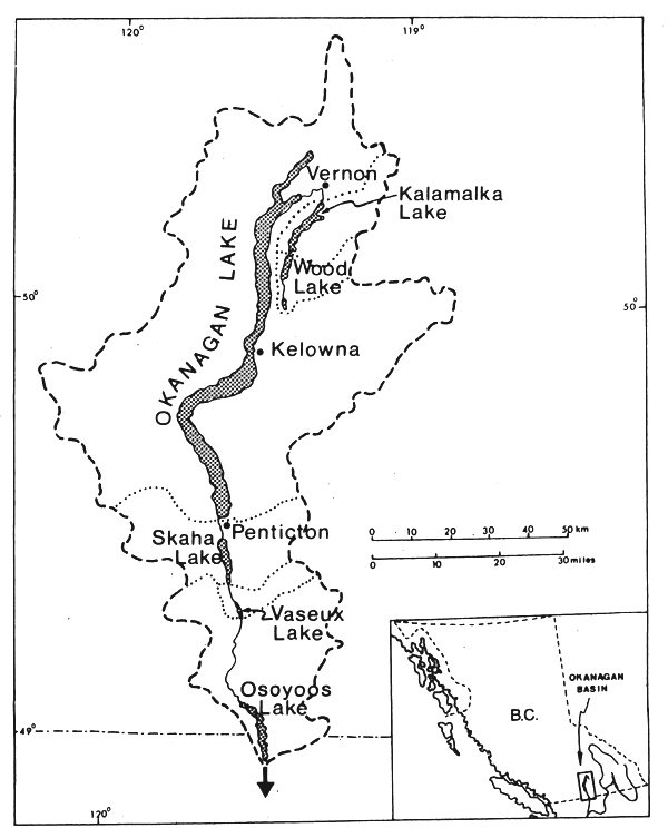
Figure 1 The Okanagan basin study lakes. Broken line shows the total drainage basin, dotted lines that for each lake; inset shows location in British Columbia
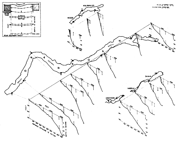
Figure 2 The Okanagan basin study lakes showing location and depth profiles for the standard netting stations, as well as position of the gillnets (:) set at regular depth intervals offshore. Inset shows typical plan view of gillnets, beach-seine sites, and echosounding track
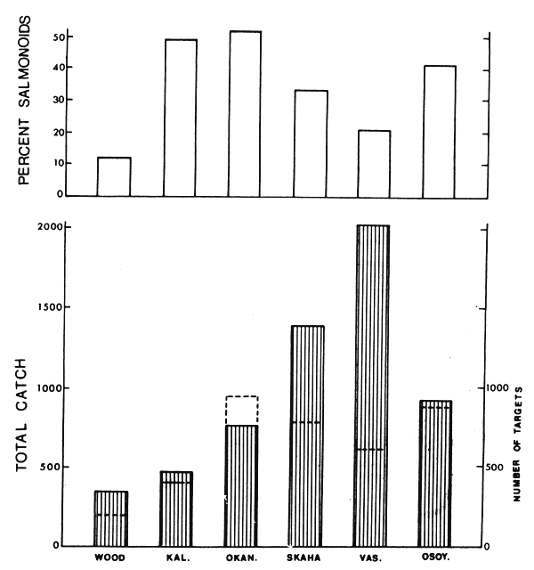
Figure 3 Lower: total catch of fish (average per station) from spring, summer and autumn standard gillnet sets in Okanagan basin lakes, 1971. Broken histograms show total number of targets (average per station) evident on evening offshore echosounder transects along standard gillnet stations. Upper: percent of total catch composed of salmonoids (Salmonidae + Coregonidae). Adapted from Northcote, Halsey and MacDonald, 1972
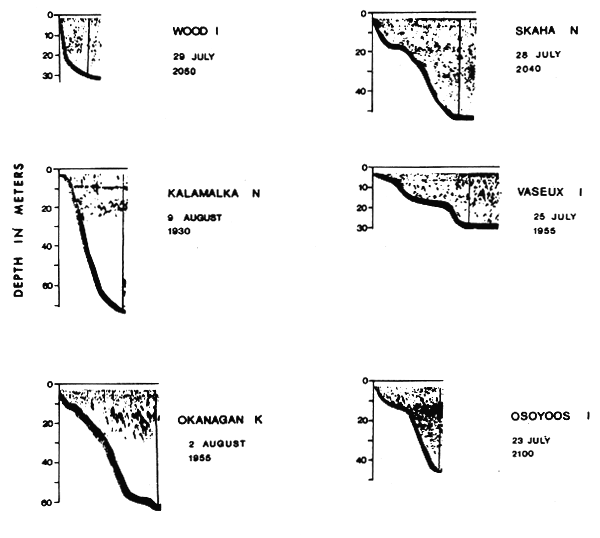
Figure 4 Evening echosounder traces along standard gillnet sets (see Figure 2) at designated stations in the Okanagan basin lakes in summer, 1971. Time (Pacific standard) tracing started given below date; vertical line near offshore end indicates outer limit of netting station; upper 2–3 m not recorded by sounder. Adapted from Northcote, Halsey and MacDonald, 1972
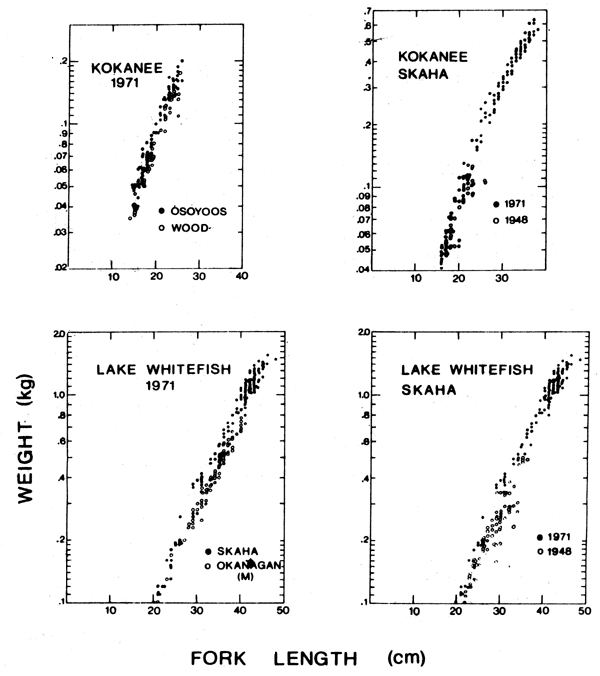
Figure 5 Length-weight relationships for kokanee and lake whitefish (Coregonus clupeaformis) in selected Okanagan basin lakes, 1971 (on left) and in Skaha Lake, 1948 and 1971 (on right). Adapted from Northcote, Halsey and MacDonald, 1972
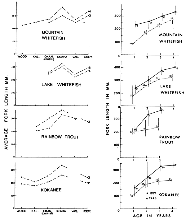
Figure 6 On left: average size of different age groups (2–5 years) of four Okanagan basin lake salmonoids in 1971. On right: average and range (vertical lines) in length for age groups (full years completed) of Skaha Lake salmonoids in 1948 (0) and 1971 (•). Sample size given near respective average. Adapted from Northcote, Halsey and MacDonald, 1972
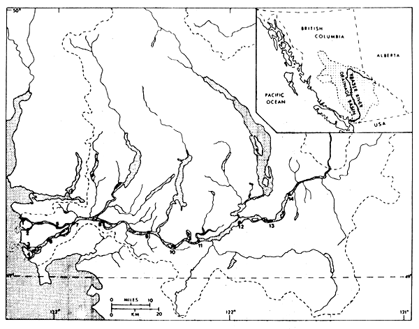
Figure 7 The location of the fourteen biological sampling stations on the lower Fraser River system. Drainage basin in broken lines; inset shows total drainage basin in British Columbia
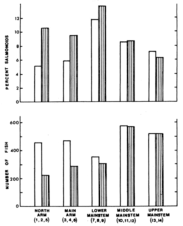
Figure 8 Lower: total catch of fish (average per station) from four circuits of standard gillnetting and seining in the lower Fraser River, 1972–73; open bars show all species, lined bars without marine species, stations within each river section given in brackets. Upper: percent salmonoids in total catch (open bars) and in catch without marine species (lined bars)
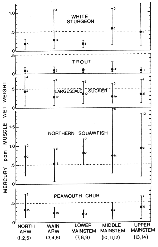
Figure 9 Average (•) and range (I) of mercury concentration in muscle tissue of lower Fraser River fishes obtained during 1972–73 survey. Sample size given at right of each mean; number of individuals exceeding 0.5 ppm given at upper range limit; trout refers to both rainbow and cutthroat (Salmo clarki clarki)
![]()
![]()
![]()