![]()
![]()
![]()
![]()
The basis of the present study is in many ways similar to traditional studies for assessing aquaculture development (Muir and Kapetsky, 1988; Born, Verdegem and Huisman, 1994). The primary difference is that the use of a GIS in this case greatly enhanced the evaluation. Most certainly, one of the greatest advantages of GIS over manual techniques is the capability to quantify the predicted potential.
This study examines how well sites satisfy criteria for small-scale and commercial fish farming and how well three index fish species (Nile tilapia, Oreochromis niloticus; African catfish, Clarias gariepinus and Common carp, Cyprinus carpio) perform under such farming systems.
Two important limitations were placed on this study to save costs: firstly, only already digitized or computer ready data could be used for the analysis and secondly, field verification was limited to using the location of fish farms in four countries (Zimbabwe Kenya, Uganda, and Malawi). Another limitation was that the data had to be comparable for all countries. Consequently, because the most important gridded data sets for this study(mean monthly daily minimum and maximum air temperature, and mean monthly precipitation) were not available for Madagascar, it was not possible to include this country in the evaluation. Similarly, the main focus of the evaluation is "land-based" due to the dependency of the data available to it.
In overview, there are three major analytical procedures in this study:
a) Criteria score classification, standardization and thresholds;
b) Integration of primary criteria; and
c) Development of the models which manipulate and integrate the selected criteria
together.
A summary of the terms and methodology used in this study are summarized
in Table 2.1.
a) Criteria score classification, standardization and thresholds
This first major analytical procedure was carried out by revising the primary spatial datasets for Africa whereby each factor was given a physical score from 1 to 4. Such a classification method was applied throughout this study in order to keep the analysis manageable and to make the results more easily comprehensible and comparable. Specifically, this classification system was used to standardize the different scales upon which raw data were measured.
The scoring levels (1 to 4) were: very suitable (VS), suitable (S), moderately suitable (MS) and unsuitable (US). This classification proved to be appropriate for three main purposes. Firstly, it was found that most raw data were classified within a range of four values. Secondly, such classification matched the FAO classification in terms of suitability of land for defined uses, and thirdly, it is the same methodology that has been used in previous GIS-aquaculture related studies (Kapetsky, 1994; Aguilar-Manjarrez, 1992;1996; Kapetsky and Nath, 1997). The level of suitability interpretation in the current study is similar to that of Kapetsky and Nath (1997), i.e., "the VS level provides a situation in which minimum time or investment is required in order to develop fish farming. For a level classified as S, modest time and investment are required, while if MS, significant interventions may be required before fish farming operations can be conducted. If the suitability level is US, the time or cost, or both, are too great to be worthwhile for fish farming".
In accordance with the suitability classification scheme, ranges of data (or thresholds) that pertain to a desired level of suitability for each criteria had to be selected. The selection of such thresholds involved interpretation of the data selected and such interpretation was guided with literature research (e.g. soils types) and opinions from expert staff at FAO. For example, for the farm-gate sales factor, the range that gives very suitable (VS) market opportunities for farmed fishes in this study, was 150-300 (inhabitants/km2).
Certain factors shared two different classifications or interpretations. In the present study, factor interpretation was dependent on how these data were assessed, on a type of farming system (i.e. small-scale and commercial fish farming), and how the factor was integrated with other factors to model a particular query.
Constraints were developed as a Boolean map (image containing ones and zeros), and were incorporated in terms of the physical space available, meaning that there are many areas in Africa which are already being used for other purposes (for example, it would not be possible to construct fish ponds in large water bodies or in urban centres), and therefore these areas were considered to be constraints. Protected regions comprising areas of conservation, wildlife and additional forest, large inland water bodies and major cities were excluded from the evaluation.
b) Integration of primary criteria
The selected and scored criteria were developed into a series of submodels (Aguilar-Manjarrez, 1992; 1996; Aguilar-Manjarrez and Ross, 1993; 1995a; 1995b) or categories of criteria (Kapetsky, 1994; Kapetsky and Nath, 1997) which logically group certain factors together within a general model. For example, some factors were grouped to form sub-models naturally (e.g. in a FAO soil classification, soil texture and soil type factors were grouped into a submodel called soils), whilst some other factors were grouped into sub-models to enable a better understanding (e.g. precipitation, potential evapotranspiration and seepage were grouped to form a water loss submodel). Mathematical expressions were used to integrate the primary criteria in this study.
c) Development of the models
The third major analytical procedure involved the development and evaluation of the models. In this study, four GIS-based models were developed:
![]() Farming systems models were
developed to estimate the quality of the land for small-scale and commercial fish farming
in ponds irrespective of the fish farming system. The model was developed by using a
multi-criteria evaluation technique through which five environmental and economic factors
were combined.
Farming systems models were
developed to estimate the quality of the land for small-scale and commercial fish farming
in ponds irrespective of the fish farming system. The model was developed by using a
multi-criteria evaluation technique through which five environmental and economic factors
were combined.
![]() A bioenergetics model was
used to estimate fish yield potential (in crops/y) for the three index species. Each grid
cell was analyzed as to its production potential for the three species under small-scale
and commercial farming conditions. The resulting output was exported to the GIS for
further analysis and manipulation.
A bioenergetics model was
used to estimate fish yield potential (in crops/y) for the three index species. Each grid
cell was analyzed as to its production potential for the three species under small-scale
and commercial farming conditions. The resulting output was exported to the GIS for
further analysis and manipulation.
![]() The farming system models
were used with the bioenergetics model to reach a combined evaluation that indicated the
coincidence of each land quality suitability class with a range of yield potential.
The farming system models
were used with the bioenergetics model to reach a combined evaluation that indicated the
coincidence of each land quality suitability class with a range of yield potential.
![]() The land quality-fish yield
outputs were combined together to indicate where fish farming potential coincided for the
three species.
The land quality-fish yield
outputs were combined together to indicate where fish farming potential coincided for the
three species.
Finally, and as an important part of the whole procedure of using a GIS, existing fish farm locations were used to assess the accuracy of the results. A schematic of the analytical procedures used in the study is provided in Figure 2.1, which is followed by a brief description of these procedures. Detailed descriptions of the models and GIS procedures are provided in the appendix for readers interested in the methodology used.
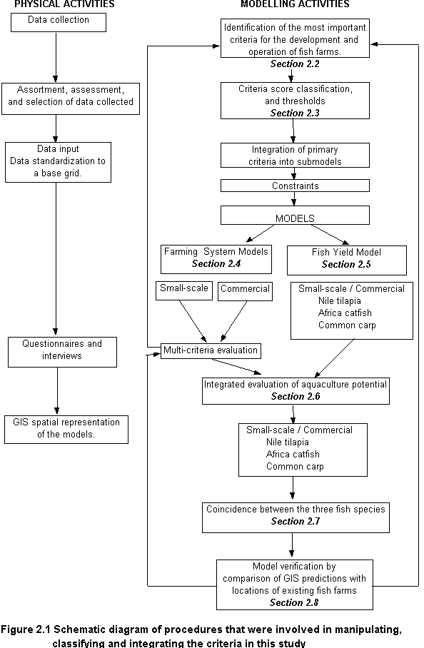
The selection of factors and constraints involved in a GIS is vitally important because they are the basis of the evaluation. To determine the suitability of locations for fish farming development in this study, it was necessary to establish the factors and constraints in Africa that were essential for the activity. It was also important to investigate whether the necessary data were available.
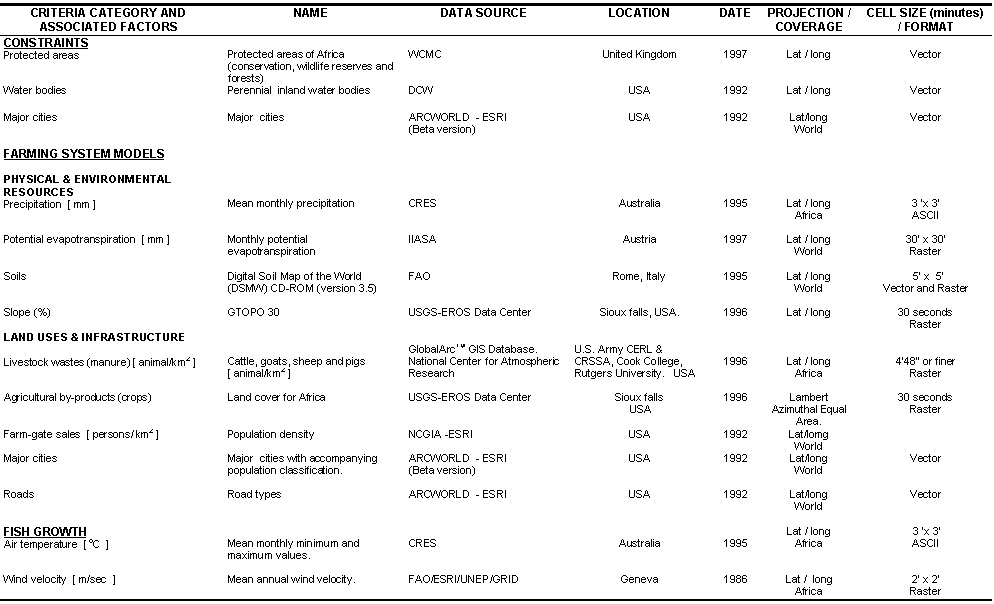
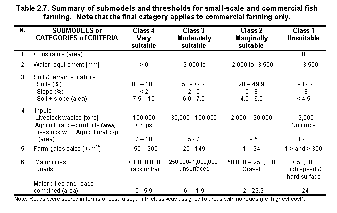
For clarity, the criteria were grouped into three categories (Table 2.2). The first category corresponded to the constraints. The second category was primarily concerned with the factors that assess the quality of the land for small-scale and commercial farming. This category was subdivided into two parts: physical and environmental factors, and land uses and infrastructure. Finally, the third category reviewed factors that dealt with the estimation of fish yields. Details regarding data sources for the various criteria are presented in Table 2.3.
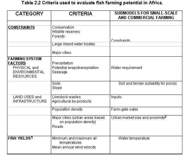
Table 2.3 Sources of data for the African database
In all, five submodels (or categories of criteria) were considered to assess potential for small-scale fish farming:
1. Constraints
2. Water requirements,
3. Soil and terrain suitability,
4. Inputs, and
5. Farm-gate sales.
For commercial farming, an urban market size and proximity submodel was added.
CONSTRAINTS
The constraints included in this study were geographical areas that were excluded for any fish farming development altogether, and were represented by the spatial area they occupied, which in turn was dependent upon the cell size used in this study (i.e. 5 km x 5 km). These areas were assigned a score of zero. The constraints were represented as a single submodel by combining all of them together.
Areas unavailable for inland fish farming development included protected areas (i.e. areas of conservation, wildlife reserves and forests), large inland water bodies and major cities, all of which were considered as constraints (see also Appendix 8.2).
FACTORS
PHYSICAL AND ENVIRONMENTAL RESOURCES
Water is essential for all forms of aquaculture and is a key factor in determining where aquaculture may develop. However, growing demands for water from an expanding aquaculture industry are resulting in increased competition with other water users for this limited resource (Muir and Beveridge, 1987; Phillips, Beveridge and Clarke, 1991; Nash, 1995).
The distribution of water in Africa represented a major determinant factor in the spatial analysis of this study. Latest predictions by the FAO (1996b) state that: "...by the year 2000, six out of seven East African countries and all five North African countries bordering the Mediterranean will face acute water shortages".
Water for levee and contour ponds may originate from several sources: precipitation, runoff, pumped or gravity water from perennial water bodies such as streams, rivers, lakes and reservoirs and pumped groundwater. However, to our knowledge, the data for these potential water sources are not available in a format that can be used to assess water requirements for a continental-level study of fish farming potential such as this one. An alternative approach (Kapetsky and Nath, 1997) with minor revisions was therefore used in the current study. This refined approach is summarized below.
Precipitation is considered the main source of water for small-scale fish farming. Other water resources such as perennial streams and rivers would exceed the economic limitations associated with small-scale farming. Kapetsky (1994) estimated water availability for small-scale farming in Africa on the basis of annual rainfall. However, rainfall in Africa is variable throughout the year (Nicholson, 1981; Lamb, 1982; Nicholson, Kim and Hoopingarner, 1988; Encyclopaedia Britannica, 1993; Gommes and Petrassi, 1994), so it is difficult to know which areas would not have sufficient water during the dry months of the year. Therefore, for this study, an estimation of monthly net water requirement from ponds was used. The main objective of the water requirement estimation was to balance inputs from precipitation against losses due to evaporation and seepage from levee ponds.
The investigation is based on a study described in an internal FAO report (FAO Water Resources, Develoment and Management Service (AGLW), 1996). This approach has a three advantages. Firstly, with this method it was possible to identify critical areas, or periods of the year, in which there would be a water deficit. Secondly, the approach indicates the amount of water that would have to be supplied in order to keep the ponds full without pre-determining the source of water and thirdly, water requirement is estimated in centimetres and therefore no assumption about the area of the pond was necessary.
In comparison to the Latin America study (Kapetsky and Nath, 1997), this study did not use evaporation; instead, it used potential evapotranspiration estimates obtained from IIASA. These estimates are based on the Penman-Monteith method, which is the most widely accepted formula and yields errors below 10%. Reference evapotranspiration (ET0) is by definition the rate of evapotranspiration from an extended surface of an 8 - 15 cm tall green grass cover, actually growing, completely shading the ground and not short of water (Doorenbos et al. 1986). Methods to calculate ET0 are, among other, the Penman-Monteith method and the Pan Evaporation method. With the latter method, ET0 is estimated from the open water evaporation of an evaporation pan (which is a small pond). Typically, ET0 is calculated by multiplying the open water pan evaporation by a factor ("pan coefficient") of 0.75 (Table 17, In: Doorenbos et al. 1986). With the Penman-Monteith method, open water evaporation is to be estimated from ET0. For the current study, we multiplied ET0 estimated by the Penman-Monteith method by the reciprocal value of 0.75, i.e., 1.3 (J. Hoogeveen, pers. comm.). The latter value is higher than the factor of 1.15 used by Kapetsky and Nath (1997), but is expected to provide a better estimate of evaporative water requirement from shallow fish ponds. Data sources and procedures used for the water requirement submodel are briefly discussed below. Complete details are available in Appendix 8.3.
Mean monthly gridded values for precipitation created by CRES at the Australian National University were obtained in the form of ASCII files. The procedure to import these files into Arc/Info is similar to the one described for the air temperature data (see Appendix 8.3).
GRID files containing monthly potential evapotranspiration values according to Penman-Monteith method for the whole world in ARC/INFO format were obtained from IIASA.
Seepage can be one of the most important causes of water requirement from a pond (Yoo
and Boyd, 1994). However, the amount of seepage will depend on the soil composition and on
the structure of the pond bottom (Coche and Van der Wal, 1981). For example, if the
composition of the soil is coarse, as in sandy soils, a great amount of water will be lost
by seepage. To account for the importance of the water requirement and the uncertainty of
the soil type, a trade-off was established by selecting a conservative seepage rate. 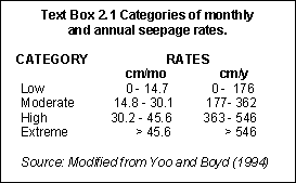
The same seepage coefficient used in the Latin America study (Kapetsky and Nath, 1997) was used. This corresponds to a loss of about 100 cm/y or approximately 8 cm/mo which is within the range of ponds that are categorized as having low seepage rates according to Yoo and Boyd (1994) (Text Box 2.1).
Water requirement for each month was estimated by using the following formula:
Water requirement = (Precipitation [mm] x 1.1) - (Potential evapotranspiration [mm] x 1.3) - Seepage ( [8.0 cm/mo] ).
In the above equation, the coefficient 1.1 accounts for the runoff from the pond side
that is in excess of the rainfall that falls directly into the pond and 1.3 compensates
for the higher evaporation from free surfaces such as small open ponds.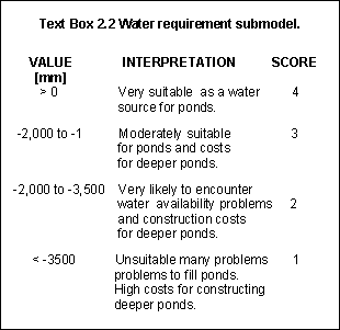
Using this approach, areas with two dry seasons could present a problem because the apparent net annual water requirement would be greater than either of the dry season losses. To evaluate the existence of two dry seasons a set of sample points was defined. These points were chosen to be at about 5o x 5 o distance to sample the monthly estimates. Four areas of this type were found at 0 o S and N, 10 o W; 5 o S, 15 o W and 10 o S, 20 o W.
As the situation of two seasonal negative minima occurred in a localized area (close to the equator), it was reasoned that the effect is minor in a continental-level study of this type.
In order to estimate the total amount of water required for ponds during the dry season, the net annual water requirement was computed using the water budget equation above for each grid cell. Estimated water requirement was then divided into 4 equal-interval suitability classes which are presented in Text Box 2.2.
According to Yoo and Boyd (1994), soil properties most common to fish pond construction
are: slope, texture, organic matter content and sulphide content. To evaluate the
engineering capability for the construction of ponds two criteria, soils and slopes, were
used as discussed below (see also
Appendix 8.4).
The assessment and use of soils is a very important aspect of aquaculture site selection, development and management. This is particularly the case in pond farms, where soil quality has a great influence on construction and maintenance costs, and on productivity. It is also important in selecting sites and developing designs for ancillary components such as water supply channels. Excessive seepage often results from improper site selection, therefore soil properties should be clearly investigated and identified during site selection (Coche and Laughlin, 1985; Yoo and Boyd, 1994).
Suitable areas for the construction of ponds in Africa have been identified by Kapetsky (1994) on the basis of soil texture and topography. However, the approach did not take into account the effects of other factors that are also important to the soils evaluation (e.g. effective soil depth, gravel and stones percentages, salinity and pH). The FAO Land and Water Development Division (AGLS) have developed a Digital Soil Map of the World (DSMW) CD-ROM (version 3.5, FAO,1995) based on the FAO-UNESCO Soil Map of the World that enables the interpretation, extraction and manipulation of all of these factors on soils, and therefore a much more accurate account of soil suitability for fish pond construction in Africa.
The objectives of this soils investigation were to:
![]() identify the soils and
terrain parameters of the DSMW most relevant to fish pond construction and operation
identify the soils and
terrain parameters of the DSMW most relevant to fish pond construction and operation
![]() define thresholds using the
class ranges already established for each parameter in the original FAO-UNESCO Soil Map of
the World (FAO-UNESCO, 1974).
define thresholds using the
class ranges already established for each parameter in the original FAO-UNESCO Soil Map of
the World (FAO-UNESCO, 1974).
The appropriate soil and terrain parameters selection, as well as threshold evaluations, were carried out by F. Nachtergaele (FAO-AGLS service).
The soil suitability ratings for fishpond construction were estimated from the soil information contained in the DSMW (FAO, 1995) at 1:5 Million scale, using a parametric approach (Sys, 1980) in which fishpond requirements were derived from limitation ratings elaborated by Hajek and Boyd (1990) as presented in Table 2.4:
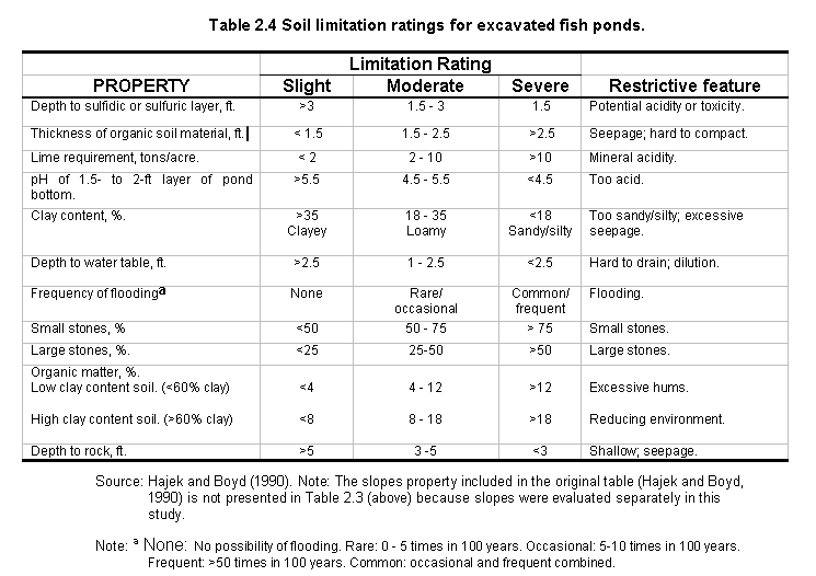
The following limiting factors were considered: presence of a sulfidic layer, thickness of organic soil material, soil acidity, soil texture, depth and risk of flooding and soil depth.
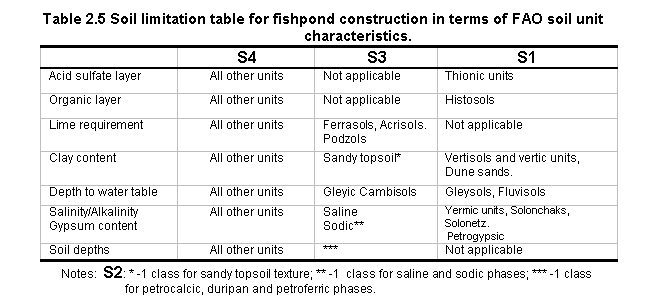
The results (Table 2.5) have been presented as proportions of mapping units as having: only slight limitations (S4), only moderate limitations (S3), one moderate limitation plus a downgrade as given in Table 2.5 footnotes (S2) or one or more severe limitations (S1) for fishpond constructions. Using the FAO-UNESCO legend (FAO-UNESCO,1974) and based on adapted guidelines of Hajek and Boyd (1990) the information presented in Table 2.5 was derived.
An overall potential production index of the mapping unit for fishponds was calculated using the following formula:
ts = S4 + 0.6 x S3 + 0.3 x S2 + 0 x S1,
where: ts = overall soil suitability using a weighted average approach. 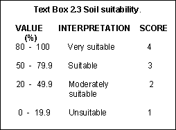
Suitability values expressed as percentage of land area covered by soils VS, S, MS or US for fish ponds, were calculated by F. Nachtergaele as shown in Text Box 2.3.
Pond layouts should account for the existing site topography in order to minimize pond construction costs , make use of gravity for water conveyance to and from the ponds, and enable efficient drainage.
The principal objective of slope evaluation was to identify areas suitable for the construction of fish ponds, the primary considerations being elevation and land slope.
An approach to the evaluation of slopes such as the previous African study (Kapetsky , 1994) was to use the slopes thresholds associated with the soils as defined in the FAO-UNESCO Soil Map of the World classification. This approach proved to be useful, but by using such data, it was not possible to select more precise slope thresholds. Moreover, the slopes resolution in the above map was found to be quite coarse for a study of this type.
 Rather than having the
slope thresholds imposed upon the soils classification, this study selected the desired
slope thresholds by calculating slopes from a Digital Elevation Model (DEM). A new
globally consistent 1 km resolution digital topographic database (the GTOPO30 or Global
Topography at 30 arc-second) was used,. This dataset was obtained from USGS-EROS Data
Center in the form of an IDRISI image file.
Rather than having the
slope thresholds imposed upon the soils classification, this study selected the desired
slope thresholds by calculating slopes from a Digital Elevation Model (DEM). A new
globally consistent 1 km resolution digital topographic database (the GTOPO30 or Global
Topography at 30 arc-second) was used,. This dataset was obtained from USGS-EROS Data
Center in the form of an IDRISI image file.
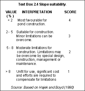
To convert the DEM into a slope image the SLOPES module was used in ARC/INFO (see Appendix 8.4 for details of methods used). The grid was then reclassified based on thresholds determined by Hajek and Boyd (1990) for excavated fish ponds as presented in Text Box 2.4.
According to ICLARM and GTZ (1991), the most suitable slopes for large ponds (1-5 ha) in Africa should not exceed 1-2%. However, for small-scale farms where most ponds will be from 0.01-0.05 ha, slopes up to 5% are most favourable. These guidelines are reflected in Text Box 2.4.
To consider the combined suitability of soils and slopes, it was considered that the former were more important than the latter. This was because suitable soils would ensure two of the most important engineering capability factors for pond construction: good water retention and good pond fertility. In particular, according to Kapetsky (1994), soil texture in Africa is more limiting in comparison to slopes.
The following formula, which gives a higher weightage to soils, was used to combine the soils and slopes criteria in an engineering capability sub-model:
Soil and terrain suitability for fish ponds = (1.5 x Soils ) + Slopes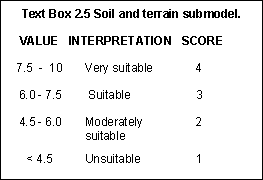
The final scores derived from this formula were re-classified into 4 equal-interval suitability classes as shown in Text Box 2.5.
LAND USES AND INFRASTRUCTURE
The main objective of this section was to pinpoint those sites in which livestock wastes and supplementary food such as agricultural by-products could contribute to the establishment of pond culture systems such as integrated agriculture-aquaculture farming.
Animal wastes are widely used as inputs in small-scale and commercial farming aquaculture systems. The objective of livestock waste estimation was to predict the amount of manure available for fish pond fertilization in Africa. Due to the lack of data on manure, we decided to use livestock numbers as a surrogate measure of manure availability.
Livestock population
Data for cattle, sheep, goats, and pigs were obtained from Rutgers University. This dataset is a global-scale environmental database, compiled from all the data contained in the Global GRASSTM CD-ROM datasets 1-5.
Amount of manure available (average livestock weights and manure production)
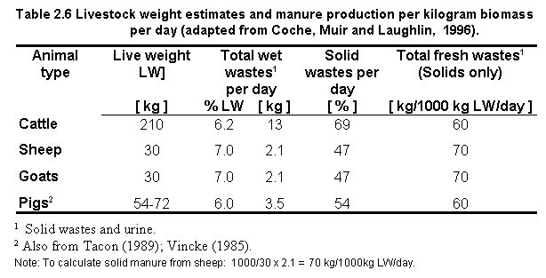
The total amount of manure produced daily by various animals depends mainly on their live weight (LW). Pigs, for example, produce a daily average of about one-tenth of their live weight in total wet wastes, consisting of solid wastes and urine (Coche, Muir and Laughlin, 1996).
Because of the increased demand of dissolved oxygen caused by the addition of organic matter to the pond water, the amount of organic manure to be applied at one time should be limited. This safe amount is usually expressed in kilograms [kg] of dry matter (DM) per hectare [ha] per day [d] abbreviated as [ kg DM/ha/d ]. Estimation of the DM content of a specific manure requires field measurements. Because collection of such data is impractical for continental-scale analyses, FAO estimates (Coche, Muir and Laughlin, 1996) on daily production of farm animal wastes were used in this study (Table 2.6). These authors provide a range of weights which correspond to typical livestock from which manure is commonly obtained. Values from Coche, Muir and Laughlin (1996) are intended to serve only as approximate estimates for planning purposes. For example, some variation can be expected due to animal species, age, feed ration, type of confinement and method of manure handling.
Calculating the total amount of manure available
To calculate the amount of manure available the following formula was used:
Amount of manure available [tons] = Livestock number [1000] x Livestock weight [tons] x Solid manure/1000 kg of Livestock.
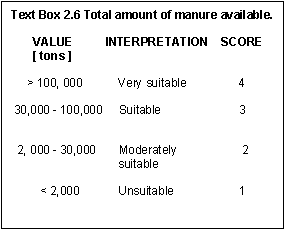
The total amount of manure potentially available was estimated by adding the calculated amount of manure available for each livestock:
Total manure available [tons] = macattle [tons] + masheep [tons] + magoats [tons] + mapigs [tons],
Detailed descriptions of these calculations are presented in Appendix 8.5. The estimated total amount of manure available was divided into 4 equal-interval suitability classes which are presented in Text Box 2.6.
Conditions encouraging agricultural production generally favour aquaculture and vice versa, and agriculture can be used as a good indicator of areas where aquaculture might flourish (Tacon, Maciocci and Vinatea, 1987; Little and Muir, 1987). In Africa, agriculture is by far the single most important economic activity and this is a good indicator of the potential to develop aquaculture (FAO, 1996a).
As noted by Kapetksy and Nath (1997), the presence of agriculture is an important indicator of aquaculture potential in two ways:
For small-scale farming, agricultural by-products can contribute to increase yields from the natural production of the pond. For commercial fish farming, such by-products can reduce feed costs by replacing some of the formulated feeds needed.
There are no digital maps of crop types for Africa that can be used to infer the availability of inputs. One approach (Kapetsky, 1994) involved assessment of the length of the growing period (LGP) and the variety of crops grown as indices of by-product availability. However, this approach is based on crop yield predictions and also does not account for inputs from livestock manure.
Crop data for this study were extracted from a land cover data set spanning April 1992 through March 1993. The dataset was obtained from the USGS-EROS Data Center. Although this land cover classification does not distinguish among different cropland types, the data are an indicator of actual cropland areas as opposed to predictions.
The land cover image contains 195 classes from which five data sets (or
classifications) can be derived. Of the five data sets, the Olson Global Ecosystem (Olson
and Watts, 1982) and the IGBP Land Cover Classification (Belward and Loveland, 1995)
schemes were found to be the most complete in terms of extracting cropland areas. However,
when comparing the classes of the original data source (i.e., 195 classes) with the
classes corresponding to the Olson and IGBP schemes, areas classified as cropland areas in
one data set were not similarly classified in another (e.g. forest and field in the Olson
scheme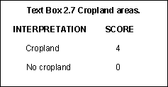 classified as
cropland in IGBP). More importantly, the 195 classes as well as their accompanying
classification do not differentiate among cropland types. Therefore, only those areas
which were classified as cropland areas in the raw data (195 classes) were selected for
this study. The interpretation to score these land areas is presented in Text Box 2.7.
classified as
cropland in IGBP). More importantly, the 195 classes as well as their accompanying
classification do not differentiate among cropland types. Therefore, only those areas
which were classified as cropland areas in the raw data (195 classes) were selected for
this study. The interpretation to score these land areas is presented in Text Box 2.7.
In designing the inputs submodel, it was considered that livestock manure was more
important compared to crops because African small-scale fish farmers usually employ manure
and by-products are used only as a supplement. For example, Tacon (1991) found that from
the 18 Kenyan fish farms visited, 83% used fresh cow manure for pond fertilization.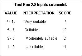
This submodel was integrated by combining the final manure scores with the cropland scores:
Manure was multiplied by a coefficient of 1.5 in order to establish a higher ranking than crops. The interpretation for the final scores derived from this weighting scheme are presented in Text Box 2.8.
Based on the methodology developed in the Latin America study (Kapetsky and Nath, 1997), market potential as farm-gates sales was inferred from population density (in individuals/km2 or i/km2).
Population density data were obtained from NCGIA (Tobler et al., 1995). The foundation of the analysis is based on the relationship among population size, density and surface area.
With territorial areas of around 30,000 km2 each, Burundi and Lesotho are amongst the smallest countries of the entire African continent. In contrast, Zambia (753,000 km2) and especially the Democratic Republic of the Congo (2,340,000 km2) stand at the other end of this range (Reynolds, 1993).
Wide variations in population sizes and densities occur from country to country in Africa and within countries. In general, the most densely populated areas are found bordering the lakes, in the river basins (especially those of the Nile and Niger), along the coastal belts of North and West Africa, and in certain highland areas, while settlement is the most sparse in the desert and savanna areas. A striking contrast is shown by the case of Burundi, one of the smallest of all African countries, with a population density of 187 i/km2 that is almost 19 times greater than that of Zambia (10 i/km2) (Tobler et al., 1995).
Clearly, differences in population size, density and surface area need to be interpreted in the context of availability of arable land and grazing areas, and the concentrations of people in places of high productivity and favourable climate or centres of industrial or commercial activity. In Burundi, for example, pressure on nearly all land resources is intense, whereas in Zambia, the very low density figure does not reflect the fact that high concentrations of people live in the industrial Copper Belt, nor that vast areas of the country comprise land of marginal agricultural utility (Reynolds, 1993).
Based on the background above, four assumptions were made for this analysis:
In a study on population growth and agricultural change in Africa, Turner, Hyden and
Kates (1993) found rural districts of more than 200 i/km2 uninfluenced in
population density by urban concentrations within them.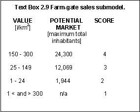
Population density thresholds were based on a trade-off between the selection of a high population density as a potential market source and the limit at which population density in terms of land would be to expensive for small-scale fish farming. The same population density thresholds used in the Latin America study (Kapetsky and Nath, 1997) were used. The very suitable range corresponded to a range of 150 - 300 i/km2. At the grid cell size of 25km2 used herein, this density range corresponds to 3,750 - 7,500 individuals. The thresholds selected to indicate potential for farm-gate sales are given in Text Box 2.9 (see also Appendix 8.6).
Urban market potential pertains only to commercial fish farming in this study. This is
because we assumed that small-scale farmers consume part of their production and either
sell or barter the surplus locally. The methodology developed by Kapetsky and Nath (1997)
was used in this study to evaluate market potential as a function of travel time proximity
and market size (in turn, a function of population levels). Complete details are available
in Appendix 8.7.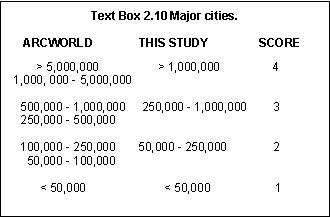
The spatial locations of major cities and accompanying population classifications were obtained from the ArcWorld datasets (ESRI,1992b).
To carry out the suitability analysis, the population dataset was re-classified into four classes as shown in Text Box 2.10.
The methodology for estimating time proximity is presented in detail
elsewhere (Kapetsky and Nath, 1997). The basic assumptions of the approach are as follows: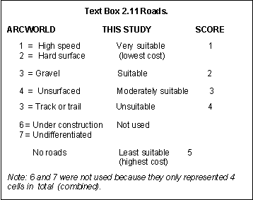
![]() The maximum time for a round
trip from the farm to the market centre was 12 hours, to preclude the cost of the driver
staying overnight away from the farm; and
The maximum time for a round
trip from the farm to the market centre was 12 hours, to preclude the cost of the driver
staying overnight away from the farm; and
![]() A speed of 90 km/h was set
for a truck over motorable roads.
A speed of 90 km/h was set
for a truck over motorable roads.
Time proximity was defined using the road system. Roads were re-classified in terms of cost (Text Box 2.11) according to ArcWorld's road type classification system. Main and feeder road travel combinations were then classified into five categories, with a maximum of six hours or less, in terms of one-way proximity.
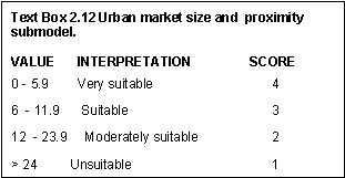 Market size and
travel time, were combined into a submodel, whereby each of the five classes of proximity
(road types) were combined with the four urban classes. The scoring interpretation of the
final result is presented in Text Box 2.12.
Market size and
travel time, were combined into a submodel, whereby each of the five classes of proximity
(road types) were combined with the four urban classes. The scoring interpretation of the
final result is presented in Text Box 2.12.
The above categories of criteria and submodels together with their corresponding thresholds, are summarized in Table 2.7, and form the basis of evaluating small-scale and commercial fish farming opportunities in Africa.
The overall objective of this section was to build models that combine the submodels described above according to their relative importance for the development and operation of small-scale and commercial fish farming systems in Africa. A schematic diagram of the procedures involved in creating these culture system GIS-based models is presented in Figure 2.2.
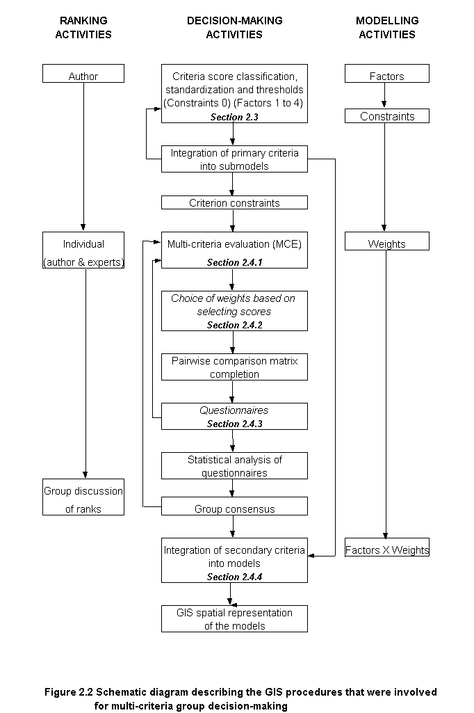
Multi-criteria evaluation procedures have received considerable attention in the GIS literature (Jansen and Rietveld, 1990; Carver, 1991; Eastman, et al. 1993; Pereira and Duckstein, 1993; Banai, 1993). Nevertheless, very little attention has been paid to group decision-making problems despite the fact that spatial decision-making problems are invariably associated with several individuals characterized by conflicting preferences. Malczewski (1996) has developed a very useful GIS-approach to group decision-making. However, this approach was based on a hypothetical decision-making situation. Examples of real applications to GIS-based group decision-making are those by Eastman et al. (1993), Aguilar-Manjarrez (1996), and Kapetsky and Nath (1997). At present, IDRISI is the only commercially available GIS software that provides a module specifically designed to support multi-criteria evaluation decision-making.
The procedure to build the small-scale and commercial fish farming models in this study was based on IDRISI'S multi-criteria, single-objective decision-making technique (MCE) developed by Eastman (1993) and by Eastman et al. (1993), and therefore described only briefly here.
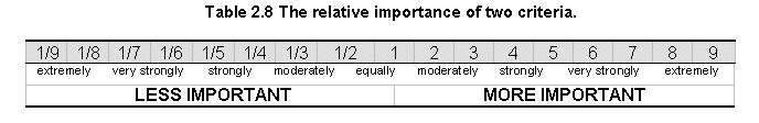
The development of weights is based on pair-wise comparisons (i.e. pairwise comparison matrix). The comparisons concern the relative importance of two criteria involved in determining suitability for the stated objective. In order to use this procedure, it is necessary for the weights to sum up to 1. Ratings are systematically scored on a 17-point continuous scale from 1/9 (least important) to 9 (most important) (Saaty, 1977) as in Table 2.8.
Based on the study by Aguilar-Manjarrez (1996), the relative ranking of the factors was made before completing the pairwise comparison matrix. Scores were assigned in rank order (Table 2.9) according to the number of factors involved in the evaluation for each type of culture system without repetition, such that a 1-4 score range was assigned for small-scale farming and 1-5 for commercial (i.e., a scale increase signifies an increase in suitability). The farming systems scores (1-4 and 1-5) assisted in the assignment of weights for each of the factors involved, but the real ranking among factors was derived from the weights obtained from the pairwise comparison matrices. Scores presented in this table should not be confused with the preceding suitability scores assigned (i.e., from 1 to 4).
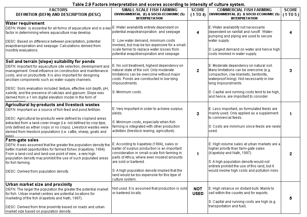
Definitions of the factors used in this study as well as a brief description of the primary data from which these factors were created are also provided in Table 2.9 above. In addition, factors are interpreted according to each farming system from an environmental and socio-economic point of view. These interpretations are presented in separate paragraphs for clarity, but the score assigned was derived from a combined interpretation of environmental and socio-economic significance.
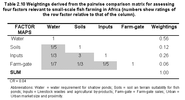
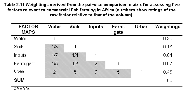
The scores presented earlier (Table 2.9) were used to simulate the assignment of weights in a matrix, and each factor was accompanied by a careful definition of its importance and description (i.e., primary data used) to make the evaluation more comprehensive. The pairwise comparison matrices developed are shown in Tables 2.10 and 2.11. The consistency ratios (CR) of 0.04 for these tables were well within the ratio of equal to or less than 0.10 recommended by Saaty (1977), signifying a small probability that the weights were developed by chance.
Although factor scores were objectively based upon real data, the assignment of weights during MCE was considered partly subjective because it was entirely dependent upon decisions made by the first author. To help reduce some of this subjectivity, to verify the weights generated, and to reach a consensus for weights, two analytical procedures were considered: 1) the use of questionnaires without group discussion for final weight consensus (Aguilar-Manjarrez, 1996), and 2) group discussion for weight consensus without the use of questionnaires (Eastman et al., 1993; Kapetsky and Nath, 1997). Because these procedures are complementary this study combined the two in order to achieve increased objectivity.
A group of four aquaculture experts from the FAO Inland Water Resources and Aquaculture Staff participated in the questionnaire (Table 2.12). The selection of these experts was based upon the following considerations: 1) similar aquaculture experience, 2) physically available to provide feedback through interviews during and after the evaluation had taken place, and 3) the same experts (except for one) involved in the Latin America study (Kapetsky and Nath, 1997) were used to benefit from the experience gained in that study.
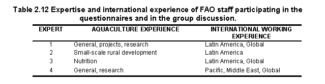
During initial testing an additional decision-maker not included in the subsequent statistical analysis, served to adjust or amend the questionnaire prior to its application.
The questionnaires involved asking the four staff members to score factors important to commercial and small-scale farming systems (Table 2.9) and to assign weights to these factors (Tables 2.11 and 2.12), in a manner similar to that used by the first author prior to contacting the experts. In addition to providing the tables (Tables 2.9 to 2.11) for the experts to complete, spaces were also provided in the questionnaire for their comments.
Scores and weights assigned by the experts for small-scale and commercial farming systems are summarized in Tables 2.13 and 2.14. These tables indicate that there is general agreement among the experts because most of the important factors were assigned high scores. For example, water requirement in the small-scale evaluation and urban size and proximity in the commercial evaluation were assigned similar scores.
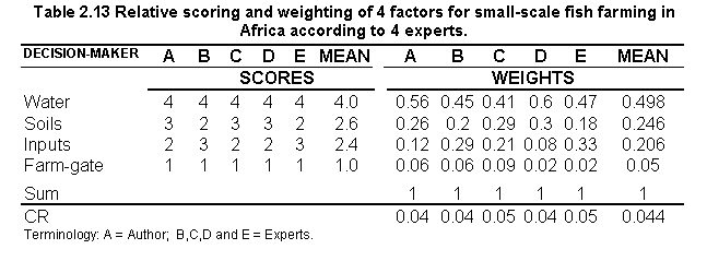
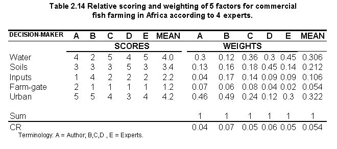
There was general agreement that the factors chosen for the evaluation were relevant. Most importantly, none of the factors were considered to be unsuitable, or were rejected from the evaluation. Some of the experts wanted to include other factors that would enhance the evaluation. For example, if data were available, a fish consumption factor could be added since wide variations in population diets occur from country-to-country in Africa (Reynolds, 1993).
The advice from the experts was very useful in the evaluation in order to verify the weights assigned by the author. Moreover, as expected, most of the staff were familiar with the decision-making methodology used (Kapetsky and Nath, 1997) which resulted in many of their comments being GIS-oriented, and therefore very valuable.
It was found that there was a strong agreement in scores for the small-scale evaluation - only one staff member ranked one of the factors differently. A good, but lower agreement was met for the commercial evaluation and this was attributed to the fact that some experts had difficulty in assigning scores because this particular culture system has a relatively short history in Africa, so it was difficult to predict the range of culture practices that could evolve in this sector.
The decision-makers were greatly benefited by assigning scores prior to completing the pairwise comparison matrices. Although some changes were made to the matrices, all the adjustments (i.e. increasing or decreasing the numbers in the pairwise comparison matrix) to meet the CR required were based entirely upon the scores assigned by the decision-makers.
The consistency ratios (CR's) of the expert group were found to be satisfactory for both the small-scale and commercial evaluation (mean of 0.044 and 0.054). Overall, the CR's developed by the first author were slightly better when compared to the CR's from each decision-maker. For the small-scale evaluation, the CR of the author was the same or slightly better than the CR of the decision-makers. However, the CR of the author was much better in the commercial evaluation when compared to the rest of the group.
To assess questionnaire results, it was crucial to determine whether the rank scores of the first author matched the position of the rank score of the decision-makers. Based on the experience gained in the Sinaloa state study (Aguilar-Manjarrez, 1996), the Kendall coefficient of concordance non-parametric statistical analysis (Kendall, 1984a,b) was used as the basis for this study's evaluation.
The Kendall coefficient of concordance W measures the extent of association among several sets of ranking, or m entities. It is useful in determining agreement among decision-makers of the associations among several factors and has special applications in providing a standard method of ordering entities according to consensus (Siegel, 1965) (see also Appendix 8.11).
To identify the consensus ranking and the best alternative according to the collective preferences, the approach by Aguilar-Manjarrez (1996) was used whereby individual questionnaires were used to evaluate the decision-makers views and perceptions about their chosen scores and weights with those that were originally developed by the first author. This new approach also enables the experts to be more familiar with the technique, develop a more thorough evaluation and thus, arrive at a more comprehensive consensus.
A comparison of the results was achieved by rank ordering the scores and weights established initially by the author and comparing them against the rank position of the scores and weights found by the decision-makers (both ranks were ordered in descending order). Since the weights had to match the scores exactly, to make a logical assessment, the rank position of the weights was exactly the same as the rank position of the scores, and hence the result of the Kendall coefficient of Concordance test was exactly the same (e.g. for small-scale farming, water requirement was assigned the highest score and hence the highest weight).
For the small-scale analysis, Table 2.15 shows that the author's results were very similar to the rest of the group. The value of the Kendall coefficient of concordance W was 0.56 and therefore the m sets of rankings were associated. In other words, the ranks established by the author agreed with those established by the decision-makers. As shown in this table, all factors matched the exact rank order when compared to the author. Clearly, both the author and the experts agreed that water requirement and soil/terrain suitability were the most important land-quality factors in this list.

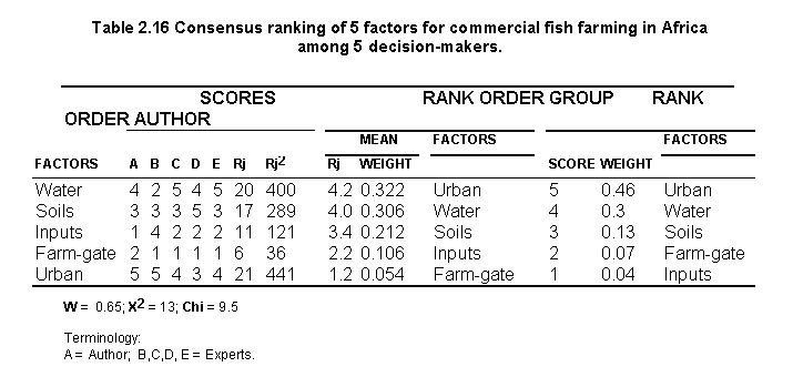
For the commercial evaluation, Table 2.16 shows that the value of W (0.65) and therefore the m sets of rankings were associated; hence most of the ranks established by the decision-makers were in agreement. Overall, 3 out of 5 factors matched the exact rank position when compared to the author. Conversely, some factors such as farm-gate sales and nutrient inputs were not in agreement between the author and the decision-makers.
At this stage of the evaluation, a group discussion should ideally take place to resolve differences in opinions. However, because the first author's results were in agreement with the staff and that valuable feedback had already been obtained through interviews during the development of the individual questionnaires, it was decided that the group consensus had already been reached and therefore, a group discussion was not necessary in this particular case.
The main objective of this task was to integrate the secondary criteria to create two models (small-scale and commercial).
Since the CR's developed by the first author were slightly better than the CR's from most decision-makers, it was decided to use the weights (Table 2.10 and 2.11) found by the first author for both culture systems.
To create the small-scale fish farming model, the four submodels which had been already classified according to a suitability score from 1 to 4 were multiplied by the authors weights derived from Table 2.10 and 2.11, and then these values were added.
The commercial model was established in a similar way to that of the small-scale model, with the exception that an urban size and proximity submodel was added to the evaluation.
Since the MCE procedure required that the weights sum to 1, when the weights (Table 2.10 and 2.11) were multiplied by the submodels (scored from 1 to 4), the overall suitability maps for each type of culture system retained the 1 to 4 suitability score range.
The fundamental factor at the macro-scale that determines the viability of an area for aquaculture is climate, because it is the primary source of water supply to ponds, and also dictates water temperature regimes, which in turn determine the species that can be cultured efficiently in a particular location (Coche, 1994; Kapetsky, 1994; Kapetsky and Nath, 1997).
Since fish are cold-blooded, their performance is directly related to water temperatures. Consequently, fish growth has been regarded as being directly proportional to the number of degree days within an optimal temperature range (ICLARM and GTZ, 1991; Kapetsky, 1994).
There are no geographically comprehensive data on pond water temperatures in Africa. One approach to estimating water temperature involves the use of air temperature because these two variables are closely correlated (Kapetsky ,1994; Webb and Nobilis, 1997). However, such approaches do not take into account the effects of seasonal variations in air temperature and other weather characteristics (solar radiation, cloud cover, wind speed and relative humidity). Heat balance models (e.g., Fritz, Meredith and Middleton, 1980) account for the effects of these variables on pond water temperature, and have been successfully applied for pond aquaculture systems (Nath, 1996). The latter model (based on gridded datasets of seasonal air temperature and mean annual wind velocity, as well as a simple generator for other weather variables) was adapted for use in this study with the intention of estimating water temperature for the entire African continent.
The fish species selected to portray yield potential in Africa were Nile tilapia (Oreochromis niloticus), African catfish (Clarias gariepinus) and Common carp (Cyprinus carpio). These species are widely distributed and have already performed well for fish farming in the continent (Coche, Muir and Laughlin, 1996).
Mean monthly gridded values for minimum air temperature and mean monthly gridded values for maximum air temperature created by CRES at the Australian National University were obtained in the form of ASCII files which were easily converted into ARC/INFO format.
Mean annual wind velocity was provided by UNEP/DEIA/GRID-Geneva, in the form of an IDRISI image file. The image file was exported into ARC/INFO and converted into an ASCII file.
Estimation of water temperature across the African continent followed the same approach used previously (Kapetsky and Nath, 1997), with the exception that annual wind speed data (UNEP/GRID) were used as input to the model, instead of a constant value as assumed by the above authors. Details regarding the water temperature simulation model itself are available in Kapetsky and Nath (1997) and in Nath (1996).
Integration of fish growth models within GIS has previously been shown to be a valuable mechanism of evaluating spatial variability in production for different culture species (Kapetsky and Nath, 1997). Fish yield estimation in the current study followed analytical approaches similar to those used by the above authors. However, different specifications (see below) were used for small-scale and commercial farming scenarios to reflect the types of culture practices found in the continent. Moreover, the fish growth simulation model documented in Kapetsky and Nath (1997) was refined in the current study to enable consideration of feed quality and high fish biomass in ponds. Model refinements and verification results are fully documented in Appendix 8.8 of this report.
To achieve the overall objectives of this study and for easy interpretation of the results, it was necessary to aggregate crops/y outputs from the simulation runs into four classes. However, specification of rigid classes that pre-judge the output values without accompanying production cost and marketing data is inappropriate. Furthermore, differences in model output were expected depending on the particular species and harvest sizes. To avoid these problems, output for each scenario within the commercial and small-scale categories was divided into equal quarters of the range of crops/y. These outputs were designated as 1st quarter (highest crops/y) (1stQ), 2nd quarter (2ndQ), 3rd quarter (3rdQ), and 4th quarter (lowest crops/y) (4thQ).
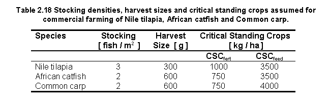
As previously noted (Kapetsky and Nath, 1997), it is difficult to precisely define "small-scale" aquaculture systems because of the wide diversity in culture conditions. For conditions in Africa, small-scale inland aquaculture will most likely be confined to fertilized ponds, and will involve harvest of relatively small fish. Therefore, small-scale farming scenarios in the current study were restricted to simulation of Nile tilapia, African catfish and Common carp growth performance under conditions where natural food in ponds was the only source of nutrition. Natural food availability was modelled as a function of fish biomass, and involved the use of the critical standing crop parameter CSCfert (Nath, 1996; see also commercial farming section below). An annual mortality rate of 20% and a stocking weight of 25g were assumed for all simulation scenarios.
Other simulation settings for the three species under small-scale farming conditions are indicated in Table 2.17. A higher stocking density was used for Nile tilapia (because of the lower harvest size) and for African catfish (because of its tolerance to crowding) compared to Common carp (Table 2.17). The CSCfert value for Nile tilapia was assumed to be higher than that for the other two species (Table 2.17) because Nile tilapia exploits this food resource very efficiently.

Kapetsky and Nath (1997) used a wide range of farming scenarios (i.e. four fish species each with two feeding levels and two harvest weights) in an effort to fully represent the diversity of commercial aquaculture possibilities in Latin America. However, because commercial aquaculture has a relatively short history in Africa (Pedini and Shehadeh, 1997), it is difficult to predict the range of culture practices that might eventually evolve within this sector.
Based on current knowledge, it appears that most commercial culture operations in Africa will involve the use of both pond fertilizers as well as supplemental feed. Consequently, the commercial farming scenarios for Nile tilapia, African catfish, and Common carp in the current study assumed that natural food availability is a function of fish biomass (Bolte, Nath and Ernst,1995). It was also assumed that supplementary feeding for all three species would commence only after the amount of natural food dropped below a target satiation feeding level of 75%. Estimation of natural food availability requires definition of the critical standing crop for ponds (CSCfert; in [kg / ha]), a parameter that is species dependent. An additional parameter is the critical standing crop for fed ponds (CSCfeed; in [ kg / ha ] ), which is used to account for the effects of crowding under high fish biomass conditions (see also Appendix 8.8). An annual mortality rate of 20% and a stocking weight of 50g were assumed for all simulation scenarios. Further, supplemental feed protein and gross energy contents (dry matter basis) were assumed to be 25% and 3.0 kcal/g respectively. Fish feed was assumed to contain 10% moisture.
Other simulation settings for commercial farming of the three target species are listed in Table 2.18. Compared to African catfish and Common carp, a higher stocking density was used for Nile tilapia because the harvest size was lower (Table 2.18). The critical standing crop parameter used to estimate natural food availability (i.e., CSCfert) for Nile tilapia was assumed to be higher than that for the other two species (Table 2.18) because Nile tilapia exploits such food resources very efficiently. The critical standing crop parameter used to account for poor water quality and crowding effects in fed ponds (i.e., CSCfeed) was assumed to be higher for African catfish than for the Nile tilapia and Common carp (Table 2.18) because this species is very tolerant of poor water quality (Haylor, 1993).
As shown throughout this study, because of the different scale upon which data is measured, it was necessary to adopt a standard classification method (or threshold). Both the farming system suitability maps and the crops/y results from the fish growth models have been scored into four suitability classes from very suitable to unsuitable (i.e. 1 to 4). These outputs were combined to make maps showing the coincidence of each culture system suitability map class with each class of the crops/y output (i.e. 1stQ to 4thQ). Model details are fully documented in Appendix 8.9.
To enhance the results found by the combined models in the preceding section, the results of the small-scale model for the three fish species were combined in order to establish where the best yields for all three species coincided. Similarly, the commercial models for the three fish species were combined to find such coincidence (see also Appendix 8.9).
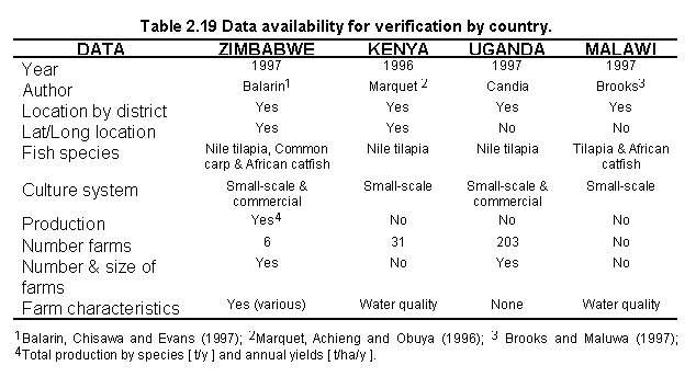
The overall goal of this section was to test the predictions of aquaculture potential made by the use of the culture systems models in combination with the fish yields models, in terms of suitability of the site and the yield in crops/y. The verification study was confined to Zimbabwe, Kenya, Uganda and Malawi due to data availability (Table 2.19), and financial constraints. Nevertheless, these four countries are important producers of cultured fish from the inland waters of Africa.
Based on the data available for each country, it was necessary to carry out four different types of evaluations (see also Appendix 8.10):
a) Zimbabwe proved to be optimum for verification, due to the large amount of data available. Farm characteristics data by Balarin, Chisawa and Evans (1997) were enhanced and expanded to suit this studies results by means of interviews and locations of farms using a Global Positioning System (GPS) for 6 farms. Data were collected and compiled by F. Zimudzi from 11-24 November, 1997.
b) For Kenya, existing Lat/Long locations of fish farms were used for verification. The water quality data available (i.e. only available for July, 1996) served to verify the water temperature predictions.
c) For Uganda, there were no accurate geographical locations of fish farms and no farm characteristics available. However, data for this country were found useful for general verification by using the numbers of farms at a district level.
d) For Malawi, data on water quality were available (i.e. annual data) for verification of the water temperature predictions.
![]()
![]()
![]()