Enhancing compliance with deforestation-free regulations and enabling local participation with Ground: Insights from user experiences in Ivory Coast

The European Union's Deforestation Regulation (EUDR) represents a step to reduce deforestation by mandating that companies and producers demonstrate that their products have not contributed to deforestation. However, the effectiveness of such regulatory frameworks relies on the accuracy and reliability of the data used to demonstrate compliance. Herein lies the importance of Open Foris Ground, a collaborative solution developed by the Food and Agriculture Organization (FAO) and Google, aimed at enhancing data collection and validation processes.
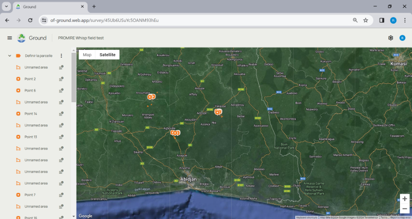
Ground is a solution designed for the efficient collection and management of environmental data. Developed as part of the Open Foris initiative, Ground leverages the robust technological infrastructure of Google Earth Engine and is designed specifically to be user-friendly, allowing non-technical users such as local farmers, small-holders and cooperatives in remote areas to easily collect, sync, and manage data even without internet connectivity. Its development can ensure the efforts of local communities are included in global efforts for forest conservation, empowering them with the technology to monitor and report changes in their environment.
Experience from the field
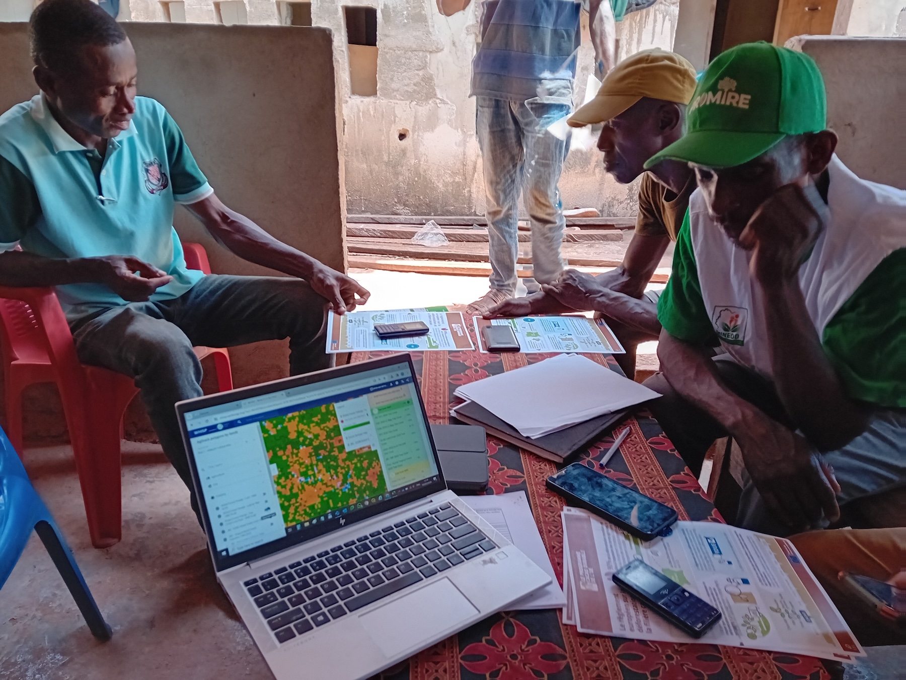
From the 5th to the 8th of March 2024, a user workshop was conducted in various locations in Ivory Coast in the vicinity of Adzopé, Sechi and Agboville. It aimed to test the Ground application with local cocoa producers involved in the PROMIRE project, which supports zero-deforestation cocoa production. The event gathered feedback from 32 participants, including 22% women, from three cooperatives. The application was installed on approximately 25 different Android mobile smartphones, from various brands and maintenance status (both hardware and software) and the Ground app was successfully installed and functioned on all devices.
This session was essential for getting feedback to improve the functionality of the Ground app, highlighting the importance of user engagement in developing technological solutions for environmental monitoring. Another thematic area covered by the Ground app was the convergence of evidence approach developed by the Forest Data Partnership and AIM4Forests, to support compliance under regulatory mechanisms for zero-deforestation value chains.
All three cooperatives involved have existing georeferenced databases of their plots, which vary in terms of how up-to-date they are. These cooperatives expressed a desire to implement the convergence of evidence approach in a straightforward manner, enabling data ownership that can support their compliance claims to regulations like the EUDR. The Whisp API, discussed during the workshop, is seen as a solution to these concerns. Follow-up actions will be coordinated by operational focal points in both regions to access these databases and relay Whisp data back to the cooperatives, thereby ensuring that the Ground app not only collects data but also enhances its verification and compliance processes.
The importance of the integration of direct user feedback into the solution development process
The pilot implementation of Ground in Ivory Coast provides a concrete example of how local insights can refine technological solutions. During field tests with cocoa producers across several cooperatives, users highlighted the practical aspects of the app, including its ease of use and the ability to perform tasks offline – crucial in areas with unreliable internet service. However, they also provided critical feedback on aspects such as the sign-in process, which required improvements to accommodate the time taken to travel to fields, and the zoom levels for offline imagery, which affected the usability of geographic data.
This feedback is invaluable as it directly influences the iterative development of the Ground app, ensuring that the solution not only meets the theoretical requirements of data collection but also addresses the practical, on-the-ground challenges faced by users, the goal is to democratize mapping and field data collection at scale. Moreover, the interaction with the local communities during the pilot revealed a keen interest in participating in the data collection process, a step that enhances transparency and accuracy in monitoring deforestation activities. As Rebecca Moore from Google highlighted during the International Day of Forests opening session, the Open Foris Ground app “has been specifically designed to empower indigenous peoples, small holders, and local communities in their actions on the ground”.
The experience in Ivory Coast illustrates a vital aspect of environmental regulation and technological solutions: the necessity of local engagement. The feedback from local users helps refine the tools to be more intuitive and responsive to local conditions. Enhanced data accuracy and reliability, driven by local knowledge and real-time data collection, can significantly improve the monitoring capabilities, leading to more effective enforcement and compliance towards existing regulations.
One of the participants, Esther Kanga, from Marie Esther Foundation, highlighted the functionalities of Ground as “a very accessible tool for everyone, including producers, and can be installed on all Android phones. What I appreciate most about the application is the ability to freely record all data and synthesize information concerning both the producer and the plantation, not to mention the possibility of extracting these data.”
Moreover, the integration of direct user feedback into the development process of Ground aligns with broader participatory approaches in environmental governance. This approach not only improves tool efficacy but also fosters a sense of ownership and responsibility among local communities. They are not just subjects of regulation but active participants in a global effort to combat deforestation. The potential of technology to transform environmental management, provided there is an active engagement with the end-users of such technologies. Ground can also help accelerate local restoration efforts and bolster initiatives to demarcate customary lands. Ground found application for demarcation of customary lands on a recent pilot in Papua New Guinea. This synergy between local insights and global technologies is where the true potential for sustainable environmental governance lies.
- Open Foris In-Action website: https://www.fao.org/in-action/openforis/en
- Open Foris website: https://openforis.org
- Ground dashboard and access: https://ground.openforis.org
- Ground github: https://github.com/google/ground-platform
- Whisp github: https://github.com/forestdatapartnership/whisp
- Ground demo session: https://youtu.be/lXTeL70Wfz4
- Forest Data Partnership website: https://www.forestdatapartnership.org/
- AIM4Forest website: https://www.fao.org/in-action/aim4forests/en