Open Foris Free open-source solutions for environmental monitoring

Check out the new Open Foris Interactive Story


Over 200,000 individual users from more than 196 countries benefit from FAO’s Open Foris initiative to measure, monitor, and report on forestry progress, take science-based actions, and accelerate forest pathways: Halting deforestation, Restoration, and Sustainable Production.


Open Foris offers various platforms for data gathering, analysis, and reporting, facilitating cost-effective and accurate monitoring of forest cover and other land covers, thus accelerating the development of operational National Forest Monitoring Systems.

Impact on the ground

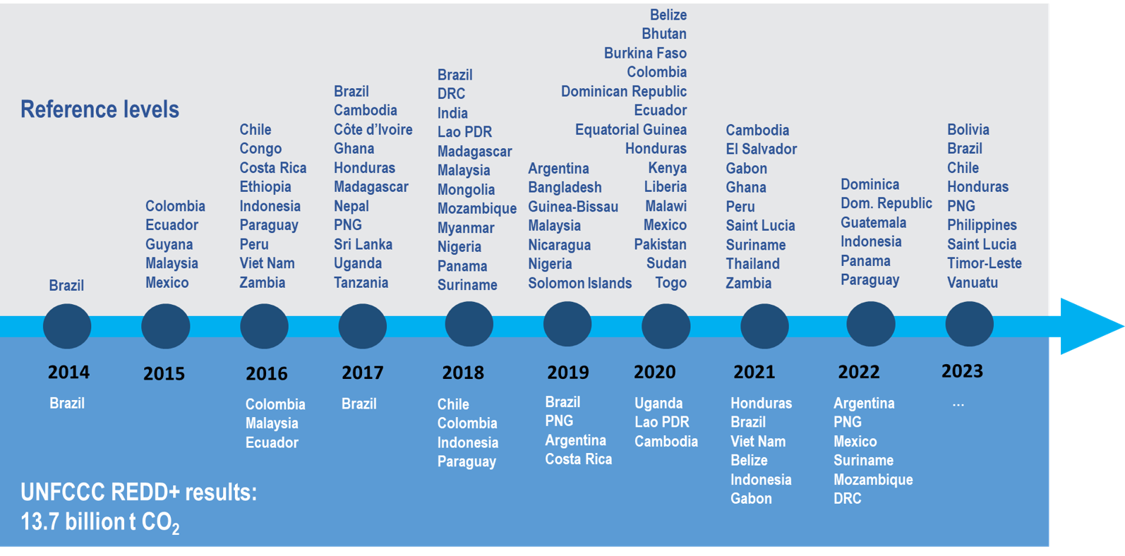
Over 13.6 billion tCO2 of forest emission reductions or enhancements have been reported to UNFCCC between 2006-2023. 

Technical innovation, demonstrated by FAO's Open Foris and platforms, like Collect Earth and SEPAL, has enabled over 90% of UNFCCC submissions during the last 10 years, enabling accurate forest measurement, monitoring, and reporting. 70% of the countries have received Technical Assistance from FAO.


60 countries submitted a reference level (it means 84 submissions)​

21 countries submitted REDD+ results through 30 BUR technical annexes (or 35% of countries with reference level)​


What 13.6 billion tCO2 (or 0.85 billion tCO2/year on average) for results achieved means?

  • That is more than the annual GHG emissions from the transport and buildings sectors combined
  • That is more than the annual GHG emissions from the US, India and the European Union combined.


UNFCCC
OPEN FORIS BY NUMBERS
 

+ 200,000 individual users

From more than 196 countries

> 13,000 people trained in using the platforms

The FAO’s Forest Monitoring for Climate Action e-learning curriculum provides free and open e-learning for all elements of forest monitoring.

To date, 5,000 learners have embarked on the learning journey and 1,000 digital badge certificates have been earned.

Try it yourself!


To learn more about each application, visit Open Foris website

Applications

Field data collection
Logo1

Ground

Simple, intuitive, and versatile map-first data collection mobile application.

Logo2

Arena Mobile

The fast, new generation data collection tool. It works with Arena and runs on Android and iOS devices.

Data management
Logo5

Collect

Easy and flexible survey design and data management.


Logo6

Arena

Online platform for survey design, data management, utilization and processing.

Visual interpretation
logo3

Collect Earth

Augmented visual interpretation for land monitoring.


Logo4

Collect Earth Online

Custom build, open-source, high resolution satellite image viewing and interpretation system.

Geospatial analysis
Logo7

SEPAL

System for earth observation data access, processing, and analysis for land monitoring.
Logo8

Earth Map

The power of Google Earth Engine without coding for complex land monitoring.