Background
Deforestation and forest degradation are complex transboundary processes with many direct as well as underlying causes. A good understanding of why and where forest disturbances occur is instrumental for the development of targeted policies and actions aiming to reduce the loss of forests and the associated carbon emissions.
The Central African Forest Initiative (CAFI) and FAO are collaborating on the development of a standardized approach to assess direct drivers of deforestation and forest degradation, piloted in six countries in Central Africa: Cameroon, Central African Republic, Equatorial Guinea, Republic of Congo, Democratic Republic of Congo, Gabon.
Central Africa is home to the second largest tropical rainforest in the world Covering 240 million ha of land, these forests play a crucial role in combatting climate change at a global level, as they represent a significant carbon sink, in addition to supporting thousands of species and millions of people.
Central African forests are however under increasing pressure from various drivers of deforestation. Among them are small and large-scale agricultural expansion, mineral extraction, infrastructure development, commercial logging as well as charcoal and biofuel production. A better understanding of these direct drivers at the regional level can help countries consolidate their efforts towards reducing and reversing forest loss.
The CAFI initiative is a partnership between Central African countries which serves to highlight and preserve the value of forests in the region, mitigate climate change, reduce poverty, and support sustainable development. Implemented by FAO, the deforestation and degradation drivers project is using a data-driven approach in SEPAL to assess deforestation, degradation and the associated direct drivers inform CAFI priorities and develop investment frameworks to support the sustainable use and conservation of forest resources.
Uses FAO’s SEPAL platform for cloud –based processing of Earth Observation Data and other tools from the Open Foris suite
Uses freely available public datasets from USGS, EU Copernicus and Planet Programme
Enables countries to perform their own forest monitoring via capacity building enabled by in-country workshops and regular online webinars.
Supports SDGs 15 Life on Land and 13 Climate Action,
Contributes to the implementation of the Paris Agreement.
- Democratic Republic of the Congo: Ministère de l’Environnement et du Développement Durable
- Cameroon: Ministère des Forêts et de la Faune
- Central African Republic: Ministère des Eaux, Forêts, Chasse et Pêche
- Equatorial Guinea: Ministerio de Agricultura, Ganadería, Bosques y Medio Ambiente
- Gabon: L'Agence Gabonaise d'Etudes et d'Observations Spatiales (AGEOS)
- Republic of Congo: Ministère de l’Économie Forestière (MEF)
- International research centres: Joint Research Centre of the European Comission (JRC), Central Africa Forest Observatory (OFAC)
Methods:
The project uses state-of-the-art approaches for robust assessments of forest disturbance, sample-based area assessments and visual interpretation of direct drivers. Four major components of the methodology are shown here. The SEPAL workflow, steps and parameters are described in more detail in the SEPAL documentation.

eSBAE
A new statistical approach to estimating areas of change integrating multiple change detection algorithms is being developed for the second phase of the project. This will enable the combination of multiple sensors and approaches, coupled with a semi-automated validation methodology to increase the efficiency of post analysis interpretation.
Validation
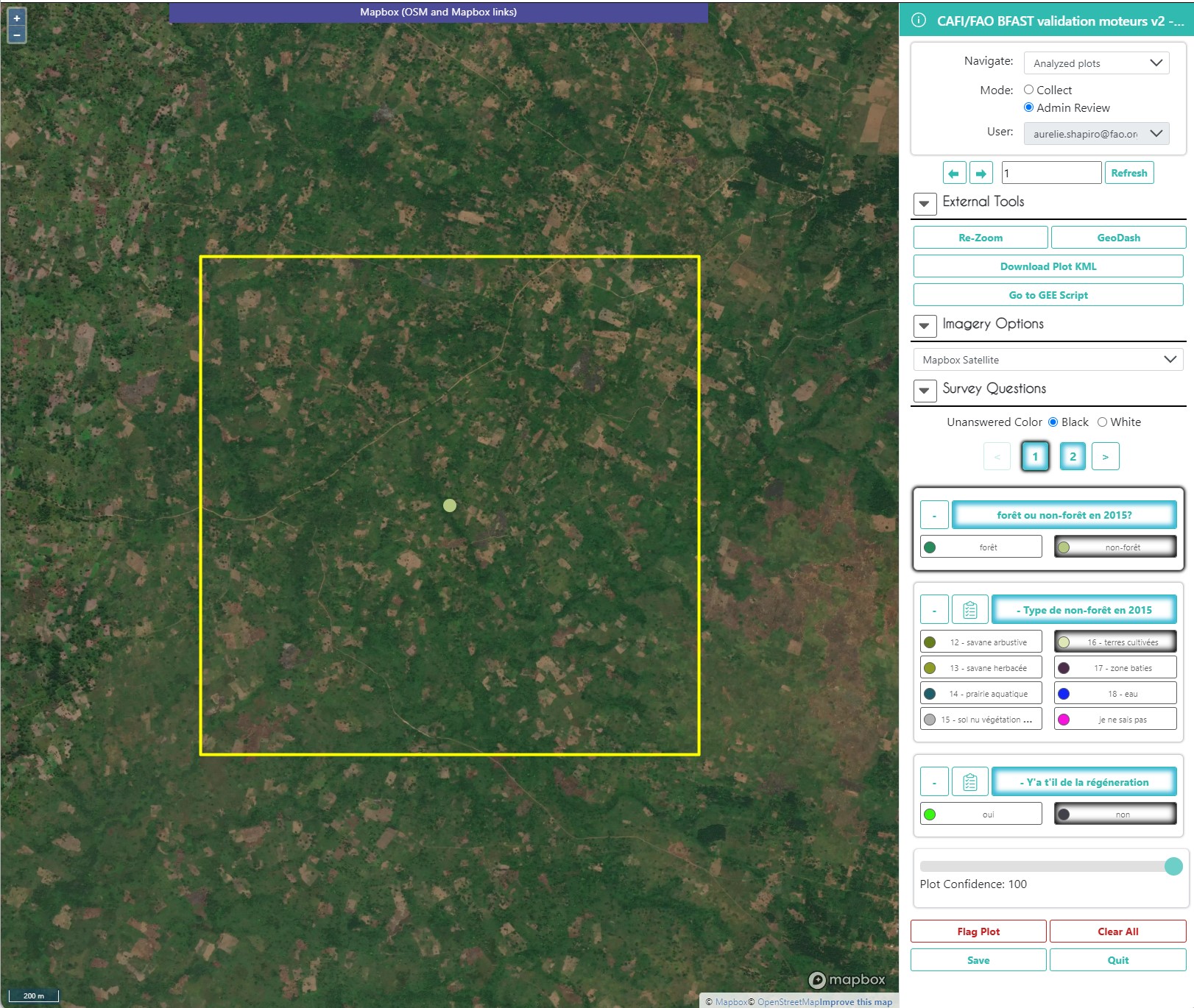
All derived data are validated through visual interpretation of high-resolution satellite imagery using Collect Earth Online. A customized online interface allows the team of more than 40 users from the region and abroad to identify forest types, change, date of change and the associated direct drivers.
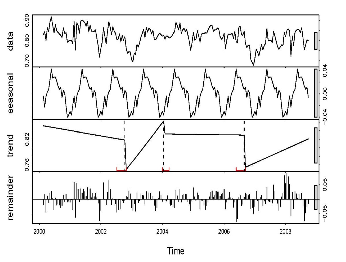
Time Series Analysis
The project uses a number of different time series analysis, which detect changes in forest cover from multiple satellite observations. Different magnitudes of change are used to discern deforestation from degradation

Regional Land Cover Classification System
Detecting changes in forest ecosystems and associated direct drivers, requires a baseline map indicating land cover, which depending on the country’s national forest definition will be classified as forest/non-forest. Official definitions of forest are not the same in the 6 CAFI countries. We developed a regional classification scheme that integrates national systems and definitions.
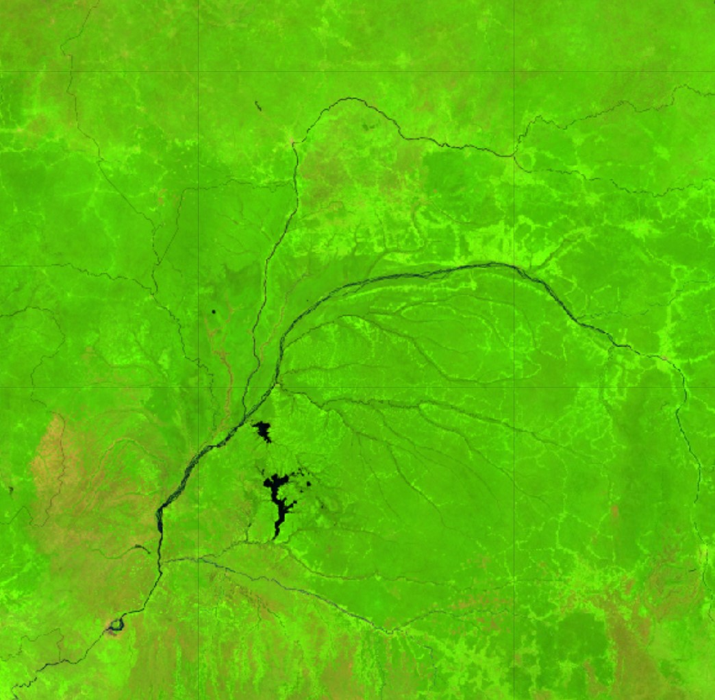
Satellite Image Mosaics
The project leverages the power of SEPAL to integrate multiple satellite observations into multi-temporal composites. Cloud-free optical mosaics combing Landsat and Sentinel-2 imagery have been produced for the entire region. These are complemented by active radar observations from Sentinel-1, ALOS PALSAR which enrich the available information for baseline forest and land cover mapping.
Results:
Project results are presented through interactive maps and dashboards built with various visualization and analysis tools inlcuding arcGIS online, Tableau, and Power Bi. Geo-spatial data are compiled in this online database including Google Earth Engine assets which can be used and visualized in SEPAL. Data are also available in FAO’s Hand-in-Hand geo-spatial platform.

Drivers Dashboard
Explore the direct drivers and the type and date of disturbance and impact on various forest types

Interactive map
All the data produced and associated with the project are visible in this Google Earth Engine App
.png?sfvrsn=90a70316_5)
Online Database
Data produced by the project are available as Google Earth Engine assets
.png?sfvrsn=5f5bb73a_5)
Validation Data Explorer
Explore the drivers analysis dashboard and driver contribution by country

Forest cover change (2015-2023) dashboard
View the deforestation and degradation estimates in Central Africa by country, forest type, along with comparisons to global datasets, with data download

Sample based area estimates (SBAE)
Access SBAE estimates of deforestation and degradation (2015-2023) with confidence intervals for six Central African countries at national and sub-national scale, as well as by forest types

A global methodology for the assessment of direct drivers associated with deforestation and degradation
31/07/2025
Despite international efforts and progress towards reducing deforestation and degradation, population growth, demand for natural resources and human...

Story map: Drivers of Forest Cover Change in the Congo Basin
A summary of the methods and results of the CAFI/FAO pilot study on deforestation and forest degradation and direct drivers in six Central African countries.

Related links
- CAFI
- FERM Platform
- Global Forest Resources Assessments
- Hand in Hand Geospatial Platform
- National Forest Monitoring
- Open Foris
- SEPAL Documentation
- SEPAL Platform