se.plan is a spatially explicit forest restoration planning decision support tool.
Using se.plan, users can identify sites with high benefits coming from forest restoration relative to the costs of restoration.
Summary
Forest restoration is defined broadly by se.plan as the establishment of tree-dominated ecosystems that provide forest commodities and services (fuelwood, timber, carbon sequestration, biodiversity, water quality, etc.). An easy-to-use interface enables any one to generate information about where trees could be planted and integrate their own datasets to improve and localize the results.
The development of se.plan is led by FAO in collaboration with:
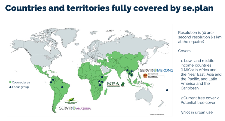
se.plan divides the Earth’s surface into grid cells with 30 arc-second resolution (≈1km at the equator). It includes only grid cells that satisfy the following four criteria:
- They are in countries or territories of Africa and the Near East, Asia and the Pacific, and Latin America and the Caribbean that the World Bank classified as low or middle-income countries or territories (LMICs) during most years during 2000–2020. These countries and territories number 139 and are listed in Countries.
- They include areas where tree cover can potentially occur under current climatic conditions, as determined by Bastin et al. (2019).
- Their current tree cover, as measured by the European Space Agency’s Copernicus Programme (Buchhorn et al. 2020), is less than their potential tree cover.
- They are not in urban use.
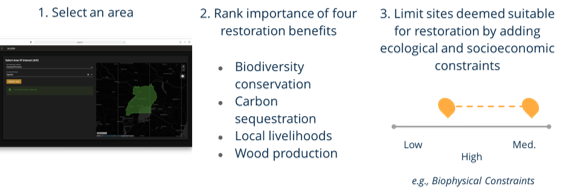
Users start by:
- selecting their geographical planning area,
- rating the relative importance of different restoration benefits from their perspective, and
- imposing constraints that limit restoration to only those sites they view as suitable, in view of ecological and socioeconomic risks.
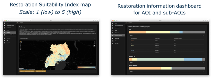
se.plan then generates maps and related information on restoration’s benefits, costs, and risks for all suitable sites within the planning area. The forest restoration costs that are accounted for are opportunity cost and implementation costs.
The outputs from se.plan are a map of forest restoration feasibility, with values 0-5, zero being not suitable for restoration because there is no biophyiscal potential for additional tree cover, it is in an urban area or it is covered by a user-selected constraint. Values 1-5 represent low to high restoration feasibility, respectively. A dashboard summaries the benefits, costs and constraint information for the area of interest.
se.plan decision support workflow
Consider national context, policy, practices, project objectives and restoration priorities when selecting the criteria
Run the tool with stakeholders inputs
Integrate custom layers
Assess with stakeholders the feasibility and suitability of restoring the identified sites
