Part two: Erosion control as a response to various erosion processes
Chapter 4. Dry mechanical erosion
Chapter 5. Sheet erosion: the initial phase of water erosion
Chapter 6. Linear erosion
Chapter 7. Mass movement
Chapter 8. Wind erosion
STATE OF RESEARCH, ANALYSIS AND APPLICATION TO LAND HUSBANDRY
Part Two will take account of the various types of erosion that have been observed, in order to adapt erosion control as closely as possible to the "ecological niches" and functional segments of each slope. The forms of erosion reflect the local efficiency of various processes - processes using a variety of energy sources, and subject to a variety of modifying factors (Table 8).
Although one type of erosion can sometimes develop into another as degradation advances (e.g. sheet erosion developing into rill and then gully erosion), each series (comprising type, cause, factors and method) will be allotted a separate chapter of varying length. Given the aim of the present work - to develop the management of water and soil fertility - sheet erosion - the initial phase of the erosive process - will be treated in greater detail, using various experimental findings. The basic principles and the results of some recent trials on methods of controlling the other erosion processes are highlighted, with reference to more specialized manuals.
TABLE 8
Degradation and erosion,
their causes, environmental resistance factors, and their
consequences are very diverse
Degradation and erosion
processes and their forms |
Causes: various energy sources |
Environmental resistance
factors |
Consequences: selectivity of
erosion and deposits |
Degradation: loss of structure |
Numerous: |
1. structural resistance depends
on organic matter, iron, aluminium, flocculated clay,
absorbed cations and soils |
Degradation involves little
sediment transport, but rather reorganization and
deposition |
Wind erosion |
Wind energy |
1. wind speed and air turbulence |
Selectivity |
Dry mechanical erosion |
Through gravity, and pressure from
tillage implements |
1. depends on intensity of
tillage, i.e., frequency and type of implement |
Selectivity |
Sheet erosion |
Impact of raindrops |
1. plant cover |
Selectivity |
Linear erosion |
Runoff energy depends on the
volume of runoff and its squared speed |
1. speed of runoff depends on
slope and roughness |
Selectivity |
Mass movement |
Gravity, slope imbalance |
1. weight of soil cover + water +
plants
|
Selectivity |
Chapter 4. Dry mechanical erosion
Definition, forms, dynamics
Causative factors
Erosion control methods
This type of "tillage" erosion is a process (removal + transport + deposition) that takes place without the action of water. Little is known about it, or its extent in quantitative terms. Through gravity and the simple pressure of farm implements, the top horizons are stripped from the upper slopes and from areas where the slope surface is irregular, and this mass of soil is then pushed down to the bottom of the toposequence, where it banks up along the edges of plots or in concave colluvial deposits whose texture is very like that of the original horizon.
Each tillage carries off a slice of earth (about 10 t/ha on a 100 × 100 m plot) and each hoeing sends several clods of earth downhill. When all this is added up, in two years time it produces a small wall 1.30 metres high (i.e. about 40 t/ha/yr) (Ecuador - De Noni and Viennot 1991) building 1-metre banks in four to five years, i.e. a rise of 20 cm per year (Côte d'Ivoire, Rwanda and Burundi - Roose and Bertrand 1971, Roose 1990).
An orchard was planted in about 1960 near Ouzera in Algeria on a hillside with a 35% slope on red fersialitic soil. Thirty years later the trees were perched on pedestals, for 30 cm of earth had been stripped away from between them. Even adding up cumulative erosion over 30 years on a bare plot (15 t/ha/yr = 1 mm), it amounts to no more than 3 cm, while creeping of the soil cover from tillage would come to 27 cm, i.e. 135 t/ha/yr (Roose 1991), as a result of two cries-cross tillages (in autumn and spring) to keep the soil bare and cloddy.
The degree of soil displacement depends on:
• the type of implement: a mouldboard plough displaces more earth than a chisel (Revel et al. 1989), a disc plough, a cultivator or a harrow;
• the frequency of passes: in a humid zone with two rainy seasons, land is ploughed twice and hoed twice; in a tropical humid zone with one season, it is ploughed once and hoed twice; in a semi-humid Mediterranean zone, it is often rough-ploughed twice and hoed twice; in a semi-arid zone, it is ploughed once and hoed once; and in a temperate zone, it is ploughed once and harrowed two or three times;
• the direction of tillage: the soil may be tilled along the contour with the mouldboard oriented downhill or uphill; it can be done from the top to the bottom of the hill (the usual case with tractors on slopes steeper than 15%); or, lastly, it can be done from the bottom to the top of the plot (usually the case with manual tilling in developing countries); it is very rare for implements to push soil uphill, and in mountain areas or where earth is scarce, soil is in fact collected mechanically or in small baskets on the level ground and carried upslope (as with vineyards); it is also noted that the repeated passage of farm machinery can significantly slow the rate of stripping by dry mechanical erosion (Revel et al. 1989);
• the slope: the steeper the slope, the more the clods dislodged by the hoe will roll downhill; in mountain areas, upper slopes and hilltops are often stripped, indicating not only sheet erosion (which has not been offset) but above all large-scale dry mechanical erosion.
Slope irregularities are also weathered, with the soil surface being lighter in colour there and the surface horizon thinner. Scouring must thus speed up where the slope is steeper, and slow down - possibly with colluvial deposition - where the slope is gentler, especially on embankments or the lower slope. On plots in the Belgian Brabant, a soil loss of 30 t/ha/yr through sheet and rill erosion has been recorded. Harvesting sugar beet or potatoes on slightly moist loamy land displaces 15-50 t/ha/yr of soil, i.e. 1-3 mm/yr. The two processes of sheet erosion and dry mechanical erosion have often been confused, with the white patches on upper slopes and breaks in slopes being taken as evidence of sheet erosion, whereas dry mechanical erosion by implements has probably two to ten times the effect of sheet erosion (Wassmer 1981, Nyamulinda 1989).
Control of sheet erosion and of dry mechanical erosion has often been taken as the same thing because the causative factors and control methods tend to overlap.
• Reducing the number of passes by implements and also the amount of tillage. There is a trend toward minimum tillage, with crop residues being left on the surface, and spring cultivation being confined to rows covering 10% of the soil surface. This most effective method has been studied in the Lauragais region in southwestern France (Roose and Cavalié 1986).
• The energy spent on tillage must be reduced. The soil does not always need to be turned with a plough. Simply breaking it up with the teeth of a chisel or cultivator aerates it in depth, increases macroporosity, water-storage capacity and rooting, and keeps organic matter and crop residues on the surface. In its most extreme form, minimum tillage can be reduced to a simple line while the rest of the soil is covered with a stubble mulch. Preparing the soil in this way cuts the risk of dry mechanical erosion from implements by 90%.
• The direction of tillage is important. If the slope is less than 14%, the soil may be worked mechanically, alternating from one direction to the other, which evens out the effect or restricts sediment transport (Revel et al. 1989). If the slope is steeper than 14%, however, tractors risk turning over, so that the land must either be divided up into cultivated strips between banks, reducing the slope sufficiently, or planted with perennial crops requiring no tillage or cover plants or mulch, or else tilled and hoed in the direction of the maximum slope but sown across the slope, with small dams, risers and bunds installed every 10 metres, or with localized hand-planted crops staggered as much as possible throughout the season.
• Banks should be built in such a way as to create horizons of run-on, fertility and soil on each level of the slope, which will in due course develop into progressive terraces. This will work only if the soil is deep enough; otherwise the banks have to be less than 5 metres apart, with some slope being kept on the cultivated terraces, tilling the land in beds or large ridges perpendicular to the slope when it is steeper than 40% (an example from the Comoros Islands).
Chapter 5. Sheet erosion: the initial phase of water erosion
Forms and symptoms of sheet erosion
Cause and dynamics of sheet erosion
Wischmeier and Smith's Empirical Soil Loss Model (USLE)
Soil erodibility
The topographical factor
Effects of plant cover
Influence of cropping techniques
Erosion control strategies
Erosion control practices
The P factor in Wischmeier's equation
Erosion control structures as related to water management methods
Variability of erosion factors
Conclusions on the applicability of the USLE in Africa
Implementation of Wischmeier's erosion forecast model
The term sheet erosion refers to the way the energy of raindrops affects the whole of the soil surface, and dislodged matter is carried away by sheet runoff. This is the initial stage of soil degradation from erosion [Plate 1].
Forms and symptoms of sheet erosion
Sheet erosion leads to degradation of the whole soil surface. This means that it is hardly detectable from one year to the next, since a significant erosion of 15-30 t/ha/yr corresponds to a 1-2 mm loss in depth - insignificant when compared with the expansion of soil, the roughness of soil after tillage (Difference in height [dH] = 2-10 cm) or the respiration of swelling clay soils simply from rewetting (dH of several centimetres). However, when combined with dry mechanical erosion (and with deterioration of macroporosity following accelerated mineralization of organic matter, or simply compacting by implements), sheet erosion can lead to removal of most of the surface horizon in a few decades (10-20 cm dH in comparison with the neighbouring profile still under forest). The most widely recognized sign of sheet erosion, then, is the presence of pale patches at the most scoured and severely affected points in fields (hilltops and breaks in slope gradient).
The second symptom is that stones are brought up to the surface by tilling implements. Farmers say that "stones grow", but what really happens is that the surface horizon melts away and deep tillage brings pebbles to the surface. After several showers, the fine soil is carried away by the rain either through deep drainage or selective erosion, while pebbles too heavy to be carried away collect on the surface (Roose 1973, Poesen 1987). If there is sand in the soil, the impact of raindrops will dislodge particles from the clods, planing them, and turning them, on the one hand, into erosion-induced or slaking surface layers (superficial rearrangement of clods) and sedimentation crusts and, on the other hand (Figure 15), into:
• veils of washed sand, white in an acid environment, pink or red if the sand is ferruginous;
• dark craters in these pale sandy veils (left by the last heavy drops of the last storm); and
• small columns that form under large leaves which protect the soil from rain splash.
FIGURE 15 Diagram of erosion, structural and sedimentation crusts (after Valentin 1979)
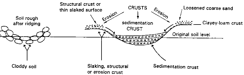
Final infiltration > 100 mm/h |
5 to 15 mm/h |
1 to 5 mm/h |
Depth |
1 to 2 mm |
5 to 30 mm |
Random succession |
1 loosened sand on 2 C-L layer |
1 C + L + OM layer on 2 loosened
coarse sand |
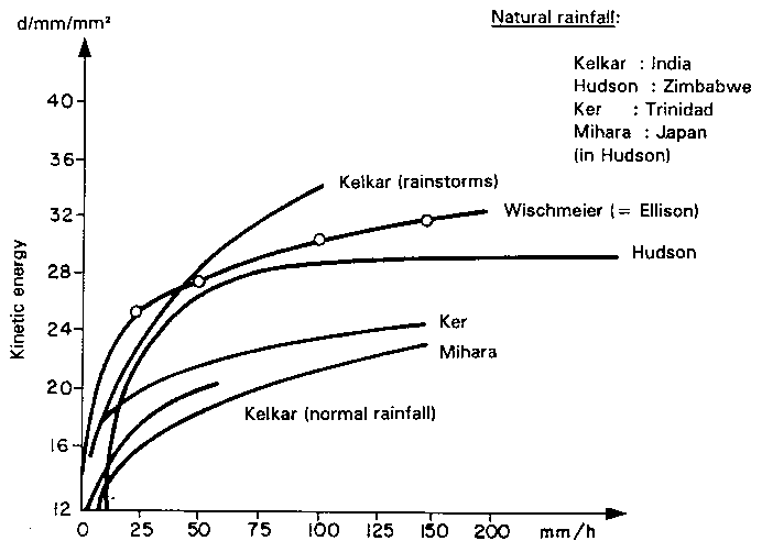
FIGURE 16 Kinetic energy of rain as a function of rainfall intensity and regions where observed
However, the most dramatic forms are the small pedestals topped with a hard object (seeds, roots, leaves, pebbles or simply crusted earth protected by lichen) which resist the onslaught of raindrops. They are higher (0.5-15 cm) when erosion is more severe, that is, on bare, relatively unhomogenous soil and on steep slopes. These little columns are proof that raindrop energy attacks the soil surface and that runoff carries off fine, light particles but that it does not have the force to cut away the bases of the columns. As soon as there is abundant runoff, it stratifies and develops enough energy of its own to attack the base and edges of its bed, and will cut down the small pedestals and leave microcliffs in their place (dH = 1-10 cm). Sheet erosion will then combine with linear erosion to form rill and interrill erosion, which can develop into grooves (Height = a few cm), rills (H = 10-50 cm) and gullies (H = more than 50 cm) if no steps are taken to correct this process of nascent erosion (= dry mechanical erosion + sheet erosion + grooves and rills) (Roose 1967; 1977a).
The consequences of sheet erosion are:
• levelling of the soil surface by degradation of clods and filling up of troughs; this leads to various smooth, whitened crusts;
• skeletonization of surface horizons through the selective loss of organic matter and clay, leaving behind a layer of sand and gravel paler than the underlying surface horizon;
• scouring of the surface horizon, leaving pale patches where the underlying mineral horizon is exposed.