![]()
![]()
![]()
![]()
From a continental viewpoint the results are generally positive. The final fish farming potential estimates for the three species together show that about 37 and 43% of the African surface contains areas with at least some potential for small-scale and commercial farming respectively. Moreover, the most significant finding of the study was that 15% of the same areas has the highest suitability score. This implies that for small-scale fish farming, from 1.3 to 1.7 c/y of Nile tilapia, 1.9 to 2.4 c/y of African catfish and 1.6 to 2.2 c/y of Common carp can be achieved in these areas. Similar ranges for commercial farming are from 1.6 to 2.0 c/y of Nile tilapia, 1.3 to 1.7 c/y of African catfish and 1.2 to 1.5 c/y of Common carp.
From a country viewpoint, the results are also generally positive. For small-scale farming of the three species, 11 countries scored VS-1stQ in 50% or more of their national area and an additional 12 scored VS-2ndQ in 25% or more of their area. The corresponding results for commercial farming were that 16 countries scored VS-1stQ in 50% or more of their national area and 8 have VS-2ndQ in 25% or more of their area.
According to the previous fish farming potential estimates by Kapetsky (1994), about 31% of Africa encompasses potential for small-scale farming of Nile tilapia and about 13% for commercial farming of the same species from which 1 to 2 c/y can be obtained. In comparison, the present study found more sites having this potential. That is, about 33% of Africa scores very suitable to suitable for small-scale farming of Nile tilapia where 0.9 to 1.7 c/y can be obtained; for commercial farming, about 36% of Africa scores very suitable to suitable with 1.1 to 2.0 c/y.
Several factors, common to any GIS-based study, had a general effect on the results of this study. These include data quality, surrogate factors, and thresholds and scoring.
Results in general
Data quality
The outcome of GIS modelling is strongly dependent on the quality of the raw data (primary data) because any errors from existing data records will likely be transferred into a GIS database; therefore, it is essential to have full knowledge of the raw data available. Moreover, due to the large, varied and complex data sets used in this study, it was considered crucial to verify the accuracy of the primary spatial datasets for Africa and the models, so great care was taken to have the most accurate and recent data to achieve the best results.
Although it was impractical to check the accuracy of the majority of the data, a number of verifications were carried out during this study. For example, on a country-level, some of the raw data for inputs were partially verified by comparison with data from different information sources (e.g., numerical data on livestock from the Ministry of Agriculture, Development and Marketing (1997), and digital data on crops by Van Velthuizen, Verelst and Santacroce (1995). Furthermore, on a site-level, some raw data verification was achieved during field work.
Surrogate factors
Although a great amount of data were obtained primarily from the USGS, there were instances when required data were not available in any form. Even if the data were available, the resolution was often inadequate for the application on hand (e.g., data were too coarse). Therefore, in many cases, surrogate data proved to be very useful. The most important surrogate data in this study were the predictions of fish growth based on water temperature, in turn predicted from air temperature and wind velocity data. Second to fish growth, livestock data proved to be suitable to infer the availability of manure as inputs, and thirdly, population density data proved useful as surrogate for farm-gate sales and for urban market potential.
Thresholds and scoring
The results were dependent upon the selection of thresholds and scores selected for the criteria, small-scale and commercial models, and fish yield models. The thresholds and scoring of such criteria established by the first author were based on decisions that were primarily derived from the literature; however, criteria will tend to vary among decision-makers. Hence, the primary goal of this study was the development of analytical procedures and assumptions for classifying and integrating the criteria.
In order to establish a consistent classification that would enable spatial comparison among factors, and to minimise subjectivity in the scoring process, four suitability classes were employed throughout the study, i.e., from very suitable to unsuitable, and from 1stQ to 4thQ yield ranges.
The 1-4 score range was useful because some of the data were already classified to a range of about four values. However, as the number of spatial manipulations increase, it is common that the number of threshold values also increase, making it more difficult to distinguish suitability classes. To solve this problem, and in agreement with the methodology developed by Aguilar-Manjarrez (1996) and Kapetsky and Nath (1997), the selection of thresholds was always based upon an examination of the frequency plots of the grid cells for each criteria, model and fish yield range.
Farming system models
Selection of weights
Results based on the first author's weighting were strengthened by comparing them with the results of questionnaire responses from a group of experts. More importantly, the overall results from the Kendall coefficient of concordance ranking test demonstrated that the rank position of the scores, and therefore the weights, were in close agreement with the experts. In all, greatest benefit from the MCE in this study was gained by the feedback obtained from the group of experts through their comments and during their interviews.
Constraints
The present study incorporated the most complete and up-to-date dataset for protected areas, about 6% of continental Africa. The grid cell size used in this study allowed the inclusion of a majority of the constraints. Results suggest that only 0.04% of Africa that appears to have fish farming potential is reserved for areas classified as constraints (i.e. there are areas with farming potential that coincide with constraint areas) like protected areas and inland water bodies smaller than 5 km x 5 km.
In order to make accurate estimations of fish farming potential and for ease of interpretation, the constraint areas were masked out from all the maps in this study. This spatial manipulation was carried out throughout this study in order to make separate evaluations of the estimates from each of the factors involved in the evaluation.
All aspects of the primary spatial datasets for Africa were standardized to allow spatial comparisons among factors. However, the areas occupied by large inland water bodies did not coincide with some of the factors. This was inevitable, because the livestock and the potential evapotranspiration data obtained had large water bodies which had already been masked out (i.e., no data) and which did not coincide with the area of the water bodies constraints used in the study (i.e., DCW data). Although the differences in areas are in general small, lakes Victoria, Chad, Malawi and Tanganyika as well as parts of Congo River have areas shown in white (i.e., no data) which could affect (to a minor extent) our estimates of fish farming potential.
Soil and terrain suitability for ponds
Slopes were evaluated independently from the soils evaluation in order to select more precise slope thresholds. This separate evaluation proved to be useful because it enabled a better understanding of the siting criteria required for pond construction. From the soils evaluation, it was found that soils scored as VS are distributed throughout Ethiopia, about 30% and an additional 46% rated S. However, and contrary to expectations, some areas in Ethiopia, that were VS and S for soils, were found US for slopes. This anomaly was also shown on the maps of the earlier Africa study (Kapetsky, 1994). According to F. Nachtergaele (FAO, pers. comm.) this irregularity can be attributed to the resolution used for both studies which did not allow the development of specific site predictions. Another way of expressing the same idea is that given the scales of the maps, predictions could only be made for a whole area (the mapping unit) and not for a specific point within it. Moreover, the fact that slope was evaluated independently sometimes leads to apparent contradictions as relatively good soils may occur in unfavourable terrain (as in the case for Andosols and Nitisols in parts of Ethiopia).
Inputs
The inputs submodel results were affected by two important factors: firstly, the 4'48" resolution available for the livestock data (used to calculate the total amount of manure available) proved to be too coarse to allow more detailed identification of potential manure sites, and secondly, even though the crops data were available at a very fine resolution (i.e. 30-arc-seconds), it was not possible to differentiate among crops types in order to select those which could be suitable as fish feed and/or fertilisers. Despite this, because the evaluation was entirely dependent upon the data available, the analytical methodology developed in this study proved to be an improvement of inputs predictions over that of the earlier Africa study (Kapetsky, 1994) which did not consider the potential availability of manure inputs.
Urban market size and proximity
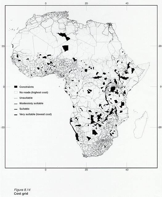
In spite of a relatively small road density in Africa (around 4%), the results of this study suggest that about 50% of continental Africa is within reasonable proximity of large urban centres that could be important for fish farming development, but that not all of these sites are favourable for fish farming. For instance, some areas in north Africa especially in Algeria, were identified as being very suitable, because Algeria has roads classified as very suitable (Appendix 8.7, Figure 8.14) meaning that the results of the submodel are logical. In order to enhance the evaluation in order to pin down unfavourable sites, it would be necessary to incorporate other factors. For example, if data were available and comparable Africa-wide, a fish price and acceptability factor could be incorporated into the cities classification to enhance the urban market size and proximity submodel. On the other hand, addition of more detailed information of this nature may be more appropriate in GIS analyses conducted for individual countries, rather than at a continental scale.
Small-scale and commercial models
The most significant difference between the small-scale and commercial models is attributable to the inclusion of the urban market size and proximity submodel in the commercial model. Because this submodel was given the highest weight in the commercial model, additional areas with potential for fish farming not identified in the small-scale model were found by the commercial model. However, some of these areas (as discussed above) should have been identified as unsuitable for areas such as parts of Algeria where water availability is likely to be a serious constraint for fish farming development (i.e., the water requirement submodel was assigned a logical weight, but the urban market size and proximity submodel needs to be refined).
Yield potential for species
Verification exercises conducted during development of the fish growth model (Appendix 8.8) suggest that relatively accurate estimates of yields can be obtained for all the three fish species. However, these exercises were conducted with more detailed and accurate data on model inputs (e.g., water temperature and feeding rates) compared to data used in the actual estimation of yields across the African continent. The results section indicates that predicted water temperatures, particularly maximum temperatures, were lower than actual values for sites where such data were available (i.e., Kenya, Malawi and Zimbabwe). These differences may in part be due to unavailability of some types of input data (e.g., solar radiation) for the water temperature model. The effect of lower water temperatures is primarily manifested as a decrease in potential fish yields predicted by the growth model, and may explain why yields in the grid cells where active fish farms exist tend to be scored lower than the actual potential. However, the lack of quantitative information on fish yields from the farms surveyed precludes estimation of the extent of the possible discrepancy. Development of a database with this information from countries in Africa should be actively pursued in the future.
Field verification work
For the purposes of verification, it was most important to analyze areas where fish
farming is practised but where farming potential has not been forecasted as first noted by
Kapetsky, (1994) and explored in detail in other studies (Ross and Aguilar-Manjarrez
(1995); Aguilar-Manjarrez ,1996). In particular, for this study, it was crucial to verify
if the predictions of small-scale and commercial suitability combined with the yield
potential corresponded to the locations of existing fish farms. 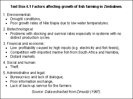
In general, there was a lack of quantitative information on farm characteristics and water temperature for the four countries for which data was available for verification of this studies results. For example, for Kenya, no data on fish farm characteristics were available and water temperature data were only available for July (see Table 2.9 in section 2.8 above). Despite this, the outcome of the verifications that were carried out for the four countries showed that the results were positive because none of the existing farms evaluated were located in areas scored as US.
Insights gained from field work in Zimbabwe
According to Zimudzi (1997) it appears that after initial enthusiasm to embark on fish farming enterprises in the 1980's, the majority of Zimbabwean fish farmers have stopped fish farming. Reasons for this trend are summarized in Text Box 4.1.
Zimudzi (1997) found that most of the farmers practised fish farming only as part of their overall activities and not as the primary focus. She concludes that fish farming in Zimbabwe has had a checkered history - there have been lots of failures as well as notable successes. The failures can perhaps be attributed to the fact that it was inevitable as the enterprise was still new, and farmers were still in a learning curve. To be successful some of the most important factors affecting fish farming (Text Box 4.1) have to be resolved (e.g. high input costs and marketing).
The present study is both more refined and sophisticated than the strategic assessment of warm-water fish farming potential by Kapetsky (1994). Nevertheless, additional refinements can be made, some of which could be carried with the existing data.
Farming system models
Scores and weights
Although a careful definition of the submodels was carried out for score assignment (see Table 2.9 in Section 2.4.2 above), an enhancement of this study would be to make separate evaluations of the submodels according to the environmental or socio-economic interpretation. In the present study, it was the combined interpretation that was used to give a score to each one of the submodels, and this score assignment proved to be difficult in some cases. For example, because the urban market size and proximity submodel was ranked first in the commercial model, this submodel tended to be socio-economically orientated. In order to make a separate evaluation, submodels would have to be reclassified or re-interpreted, but overall submodel classification depends on how they are integrated to model a particular query. Therefore, reclassifications and trade-offs will vary.
It is evident from this study that different results can be produced at the weighting stage, due to different individuals considering different factors to be more or less important to their own objective. Nevertheless, a strong general consensus was obtained and because it included the expert opinion from various decision-makers, this combined technique gave very useful results. However, as noted by Kapetsky (1994) uncertain data quality in a large database can have a negative influence on the weights assigned by putting more reliability on the results than they deserve. Therefore, to enhance the selection and adjustments of weights, information about the quality of the data should be included in the questionnaire provided to the decision-makers.
Likewise, the maps for each of the submodels had not been completed when the experts were brought in for weight assignments. It is likely that the inclusion of these maps in the questionnaire may have influenced their weighting priorities. Moreover, even though a group consensus for weights was achieved in this study, the greatest benefit from the MCE technique can be realised by bringing experts together to discuss the different scenarios created for the farming system models. This can be accomplished based on iterative weight selection and assignment on the computer screen in order to make final weight adjustments.
In terms of improving model outputs, weightings could be derived from local people. Moreover, it would be an interesting exercise to compare weightings derived from technical experts with those produced by socio-economists and by local planners and local farmer groups (M.C.M. Beveridge, pers.comm.).
Constraints
Nile tilapia, African catfish and Common carp were selected as "index" species for the modelling purposes of this study to evaluate the absolute and relative performance of such species across Africa. However, there is growing concern about the impacts of species introduced for aquaculture purposes on indigenous fish communities and fisheries yields. In Malawi, for example, Common carp and other introduced species are excluded from aquaculture in the Lake Malawi basin area. In other words, there are already conservation areas of sorts excluded from the constraint areas of the present study (M.C.M. Beveridge, pers.comm.). Therefore, if spatial data on introduction of fish species were available Africa-wide then this data would be incorporated into the constraints submodel of the present study.
Water requirement
The water requirement estimation benefited from data available for potential evapotranspiration based on the Penman-Monteith method which is the most widely accepted formula, yielding errors below 10%. However, such data were only available at a 30 arc-minute grid resolution, therefore, the most significant improvement to this submodel would be the increase of resolution of this data (e.g. to 3-arc-minutes).
Data on groundwater availability would enhance the present water requirement estimation to assess fish farming potential in drier areas. For example, Zimbabwe is a country with relatively low rainfall, but where groundwater is perhaps the most important source of water for fish ponds (Kapetsky, 1994).
Interpolation of cities
Major cities are commonly represented spatially as points, therefore, the land areas are small and their size is dependent upon the spatial resolution used. Thus, in some cases, real urban areas may have been underestimated. To solve this problem, an interpolation procedure would have to be carried out for each of the cities according to its population density, the basic assumption being that the higher the population density, the larger the spatial area occupied by the city. The interpolation procedure would improve the constraints submodel by masking out the real urban areas from any fish farming development, and the urban market size and proximity submodel by allowing more accurate calculations of market proximities.
Livestock wastes
An increase in the resolution of the livestock data used to estimate the total amount of manure available would be the most significant improvement to the inputs submodel. Moreover, if data for fish pond areas were available for the whole of Africa, the manure estimation would be greatly enhanced. For example, animal manure application rates for fish pond fertilisation (e.g. Auburn University, 1997) could be used, along with the number of pond areas, to make a rough estimate of the amount of manure needed (e.g., by the multiplication of these two factors). Also, it would be possible to estimate the amount of manure needed as opposed to that actually available by calculating the percentage ratio between these factors (i.e., manure needed/manure available x 100). A low percentage would indicate that the amount of manure available is ample, and therefore, in these areas the amount of manure needed would in fact be available, even if most of it was being used intensively for other production activities like agriculture.
Agricultural by-products
It was not possible to differentiate cropland classes in order to assist in identifying suitable crops for fish culture. However, recent updates of the 1 km land cover data from the USGS, from which the cropland classes were obtained, do give some indication that these types of problems will be resolved in the near future. In the long term, cropland classes from the land cover map could be differentiated with the help of two FAO projects: AFRICOVER (FAO, 1997) will create a digital georeferenced database on land cover and a geographic reference (geodesy, toponomy, roads, hydrography) for the whole of Africa, and AGDAT (FAO Agrometeorology Group, Environment and Natural Resources Service (In prep.)) will provide digital agricultural data at a sub-national level.
Multi-objective land allocation (MOLA) decision-making technique.
To assess final fish farming potential, the interaction with other production activities competing for resources must be considered as some of the identified areas that have potential for fish farming in this study are reserved for other uses.
The MOLA technique developed by Eastman (1993) has been created to evaluate the interaction among production activities. This technique also involves the use of weights and could be used in this study to establish the relative strength or priority of each activity with respect to fish farming development. This technique could help identify wider management options and help resolve conflicts of land allocation and land use. Likewise, by using MOLA, a compromise among activities could be established in order to make a better use of the natural resources available. Two good examples of applications of the MOLA technique for aquaculture are: 1) Aguilar-Manjarrez (1995a,b; 1996), when assessing conflicts in Sinaloa, Mexico between shrimp farming development and other production activities like agriculture, and 2) a more sophisticated one, outlined by Looijen, Pelesikoti and Staljanssens (1996) when evaluating conflicts between mangrove forest conservation and the development of shrimp culture in mangroves in Thailand.
Dynamic aspect of the models
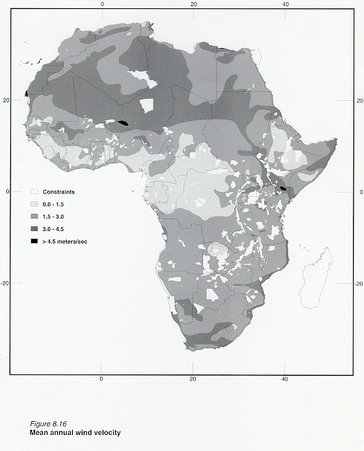
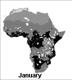
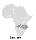
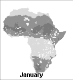
Inter-annual variations in temperature affecting fish growth and production (Appendix 8.8, Figures 8.15, 8.16 and 8.17), and variations in precipitation and evaporation affecting water availability (Appendix 8.3, Figures 8.1, 8.2 and 8.3), are clear indications that the application of the models developed in this study are subject to many changes, so the dynamic aspect of the models should be further developed. Kapetsky and Nath (1997) mention that these types of weather data could be used to look at best and worst cases for the operation of ponds and for the production of fish.
Field verification
Clearly, verification results show that a large number of factors affect the development and operation of fish farms. This has to be taken into account while assessing results of the current study because only five general factors (in weighted combination) were used in the farming systems models developed. Nevertheless, as more data becomes available, it should be possible to incorporate more factors that are important for the development of fish farming. For example, the development of a well classified, high resolution land cover map, should allow the extraction of relevant data for fish farming such as crop types and urban areas.
Other refinements that would require new data or new approaches include:
![]() A complete set of climate
data to allow inclusion of Madagascar.
A complete set of climate
data to allow inclusion of Madagascar.
![]() Once the 1 km land cover
classes are further defined by the USGS, these data will allow the present study to use
the MOLA decision-making technique to make better estimates of land actually available for
aquaculture.
Once the 1 km land cover
classes are further defined by the USGS, these data will allow the present study to use
the MOLA decision-making technique to make better estimates of land actually available for
aquaculture.
![]() Since the GIS evaluation in
this study was primarily "land-based" (i.e., based upon the data available), it
is vital that "water-based" data are incorporated into the GIS system (e.g.,
using remote sensing data). The primary reason for this would be to further improve water
temperature estimations.
Since the GIS evaluation in
this study was primarily "land-based" (i.e., based upon the data available), it
is vital that "water-based" data are incorporated into the GIS system (e.g.,
using remote sensing data). The primary reason for this would be to further improve water
temperature estimations.
![]() Extend the study to include
cold-water species such as rainbow and brown trout.
Extend the study to include
cold-water species such as rainbow and brown trout.
![]() Improve the fish growth
model to investigate polyculture opportunities.
Improve the fish growth
model to investigate polyculture opportunities.
![]() Increase the number of fish
farms to be verified in the field for both types of culture systems and for the three fish
species.
Increase the number of fish
farms to be verified in the field for both types of culture systems and for the three fish
species.
![]() At a national-level, the
present study could be extended to include cage culture and commercial aquaculture geared
towards export markets. In Zimbabwe, about 1500 t of tilapias will be produced from cage
aquaculture in 1998 and there are plans to increase this substantially over the next few
years, making it one of the more important sources of farmed fish in the country (M.C.M.
Beveridge, pers.comm.). Investment decisions by multinationals with commercial fish
farming interests are made on the basis of political stability as much as by factors such
as water quality and soils - domestic markets are unimportant; proximity to airports,
however, would be (M.C.M. Beveridge, pers.comm.).
At a national-level, the
present study could be extended to include cage culture and commercial aquaculture geared
towards export markets. In Zimbabwe, about 1500 t of tilapias will be produced from cage
aquaculture in 1998 and there are plans to increase this substantially over the next few
years, making it one of the more important sources of farmed fish in the country (M.C.M.
Beveridge, pers.comm.). Investment decisions by multinationals with commercial fish
farming interests are made on the basis of political stability as much as by factors such
as water quality and soils - domestic markets are unimportant; proximity to airports,
however, would be (M.C.M. Beveridge, pers.comm.).
![]()
![]()
![]()